Video from city council starting with request to approve negotiations with Omni Hotels
It’s all going according to plan.
Straight out of the 2015 Downtown Plan, the southern end of Fayetteville Street, currently being used as surface parking and owned by the city, was to be kept for a major “catalytic” project. In 2015, it was envisioned that a major hotel to serve the convention center and a large corporate relocation would set up on the two sites. Fayetteville Street would then be extended down the middle.
[Quick note, most of the photos here were taken on a weekday morning. I was trying to beat the heat plus it’s been a busy summer for me. I mention this because I typically try and get photos with people in it as that is more interesting than the opposite but sometimes you can’t help when inspiration strikes, am I right?]
Announced back in July of this year, the Downtown Raleigh Alliance (DRA) and the city have partnered with a few consultants to create a plan for Downtown as the last few years have seen unanticipated changes. The largest of those being the uptick in remote and hybrid work and how downtown businesses were reliant on a certain number of workers coming to the office and frequenting them for lunch and goods. It is also a great time for a new plan as the previous downtown plan was implemented in 2015 and plenty of policies and recommendations from that one have already been put in place.
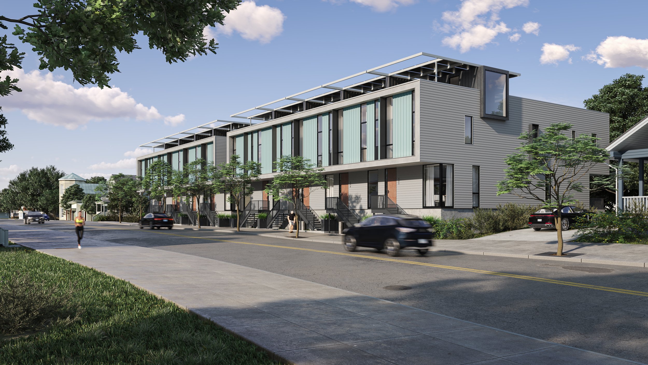
Above is an artist’s rendering of a new project, already under construction, at the corner of Bloodworth and Cabarrus Streets. The Raleigh Architecture Company has designed ten homes here and the sales website claims that they are net-zero energy homes.
I’m getting so bad at blog post titles these days. I really do apologize for that one.
What I am getting better at is working with maps and data. It’s still a work in-progress but I wanted to put out this map, shown above, related to the currently proposed New Bern Station Area Plan. You can jump into this topic over at the city’s website as well as this post from Jan 2023.
OK. It doesn’t say that exactly but after seeing the tweet below, I couldn’t help but take a second look at the Downtown Raleigh Alliance 2023 Q1 report and count up those residential numbers.
There’s a big rezoning case that’s now being discussed at council. Basically, a majority of Shaw University’s campus is up for an increase in height, if approved. There has been a lot of public comment on this one, from residents and alumni, with concerns. In short, the university is sitting on very valuable land and with the ability to build taller, they can explore options to expand or even partner with developers to lease land for new development.
It has now been 16 years since I started the blog and I couldn’t be happier with the current state of it. There are still new readers that are discovering it for the first time as well as long time followers who are sticking with me. I appreciate all the kind words everyone has sent in and for any of your contributions including eyes-on reports, photos, and curious thoughts.
This is an excellent time in the post to state that I also appreciate those who have contributed financially to help with the maintenance of this site as well as the chattier, sister site, the DTRaleigh Community. I only ask once a year but if you find value, in any way at all, for the online work that I do about downtown Raleigh, consider a small tip over here through my Paypal. Suggested amount is currently at $16 so get it in now before it’s $17 next year.
I can’t help but put it out there that I am having a BALL being in and around downtown Raleigh. Things are still kicking and there is no shortage of fun times to be had. Food and drinks are top of mind but I’m including other things like events, museums, music, performances, and the arts. With a little planning, a lot of people can have a great day or night out in downtown.
However, being a local, and running a blog for over 16 years, means you start to notice some things, some trends.
If you are a local news junkie like me, the headlines aren’t helping downtown Raleigh. This is a hard perspective to see, as a local, but I feel that if you have never been to downtown, or the city in general, judging us by the news and online chatter will tell you a few things. The main one I wanted to call out today is a perception that we’re demolishing all our historic buildings and replacing them with soulless glass towers.
Defining historic is tough and very subjective. What is a historic building anyway?
The underlying frustration from locals is probably seeing parking lots, some of them not even paved but made of gravel, remain in downtown while century-old buildings, perfect for renovation, are instead torn down. The opinion spectrum is wide on this topic but I have a working theory that the loss of the business inside an older building is more valuable than the building itself.
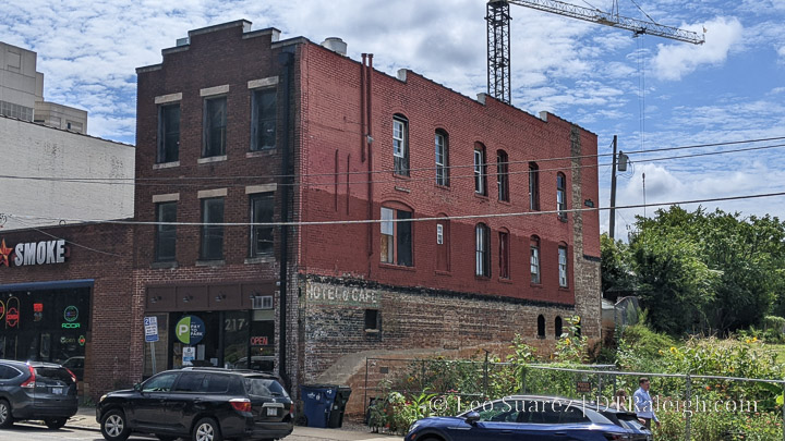
Take for example The Berkeley Café at 217 West Martin. If the building was empty, would the rezoning case that threatens demolition have been amended later to exclude the building? I don’t think it would have been. It helped that The Berkeley was there and the owners removed the rezoning of 217 West Martin and even extended the lease for The Berkeley.
Another example is Goodnight’s, the comedy club formerly at 865 West Morgan Street. Would the demolition of their location have been so news-worthy if locals thought Goodnight’s was closing for good? I’m not so sure it would have been.
Today, Goodnight’s moved over to nearby Village District but the building at 865 West Morgan is now gone. The Berkeley Café is still open in the same location but the future of the business, and the building, is still undetermined.
So which story are you reading? The possibility of Goodnight’s or The Berkeley Café closing or the demolition of the buildings they occupy?
I think the point I’m trying to make is that it’s so important to support the people, typically that’s also their local business, that is affected by the changes going on in downtown Raleigh. We have national attention on us now and while some big-time projects are good for the health of the city, it can’t come at the expense of the people who are making downtown local.
I feel this is ultimately what people want, more so than to save a building. We want local tastes to thrive and the growth threatens that, more so than just tearing down buildings from past centuries. At least that’s the theory I’m working on.
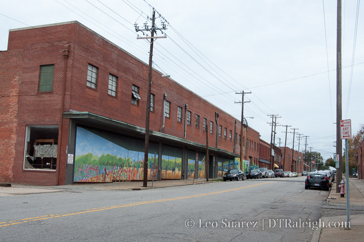
This brings me to my header image at the top. Here is West Street in October 2012. This is before The Dillon, Raleigh Union Station, Citrix, and Morgan Street Food Hall. At the time, I would have called this a pretty dead street. Other than Five Star, this area didn’t have much going on as a majority of that warehouse space was empty.
Today, the street is obviously very different and tends to be vibrant throughout the day. Even more is coming to the area and while some hate to see the demolition of the warehouses, I just can’t get behind it when you think about what is was like and what it is now. Even more so with the fact that the buildings were empty. Five Star did relocate further down West Street by the way.
Now it may be a huge hassle for a business to move like Goodnight’s or Five Star did. I don’t know, I’m not a business owner, but it can be done and I imagine it’s easier when locals like us support them through it. That’s what’s really important and what drives downtown vibrancy from my perspective.
I’ll leave it at that for today but next time, as I’m sure it’ll happen again, when an older building facing re-development hits the news, think about the local businesses that are affected and your feelings towards the building itself. As always, make sure you are spending your dollars at these places cause that is the best way to help them out and keeping downtown local as much as freakin’ possible.
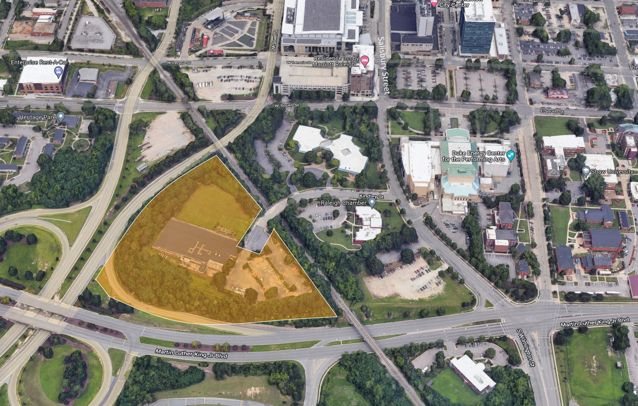
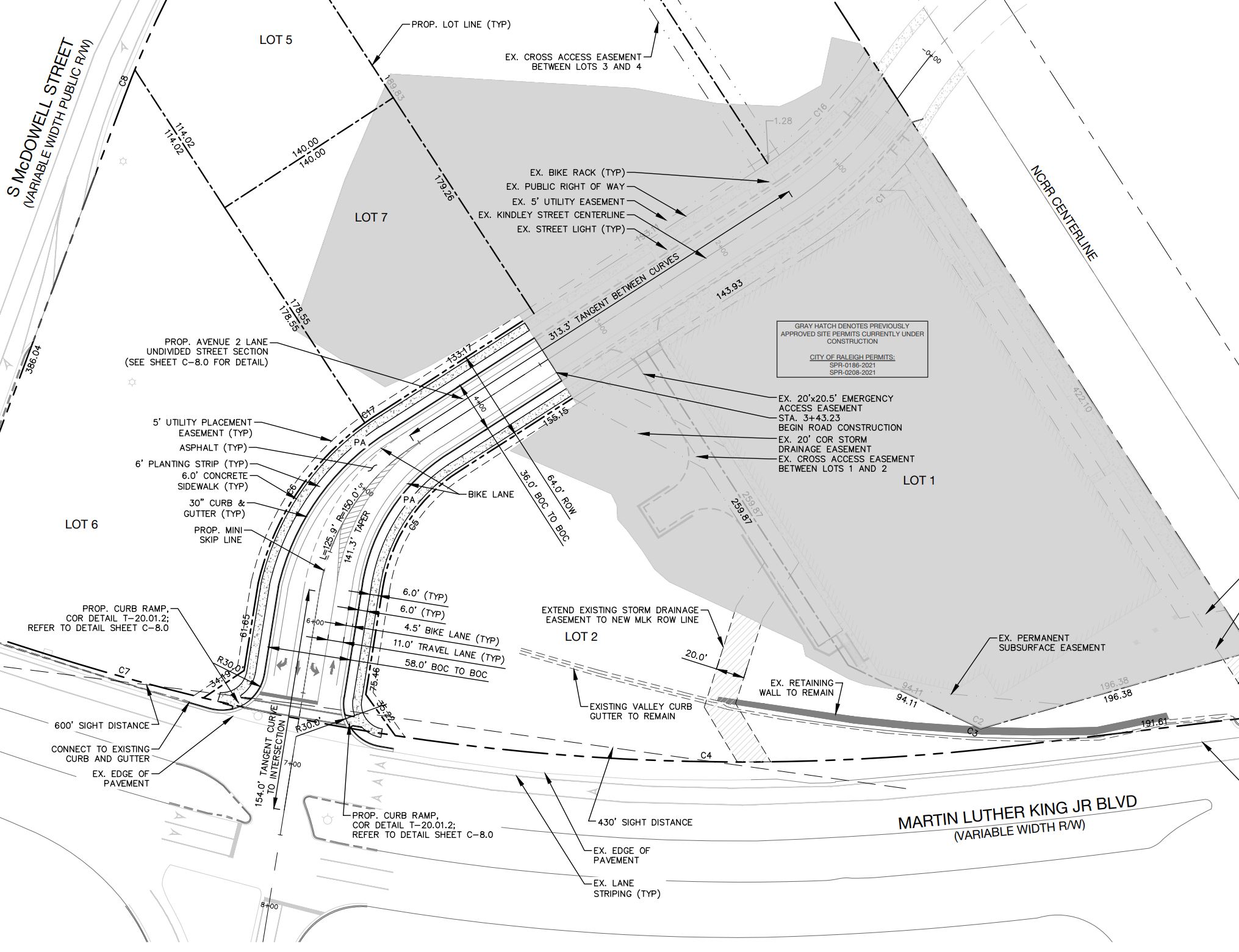
Kindley Street is not mentioned all that much in the news. Mainly because it is a dead-end street that branches off Salisbury Street. In this section of downtown, there have been one-story, suburban style office buildings probably since the 1980s. (or even earlier) That dynamic is already starting to change.
Zooming in, I am mostly talking about some land that is southwest of the train tracks crossing Kindley Street. A collection of properties have been acquired and there is a new rezoning on the table to raise the height limit from the current 20 stories up to 40 stories. In addition, construction of a building with 288 apartments is already taking place. Finally, we may see Kindley Street connect to Martin Luther King Jr Blvd in the future.
You can see the site in the google map aerial above, highlighted in orange. Again, it’s probably not an area most go to as Kindley dead ends and there isn’t much there to begin with. (more so now after all the recent demolition nearby)
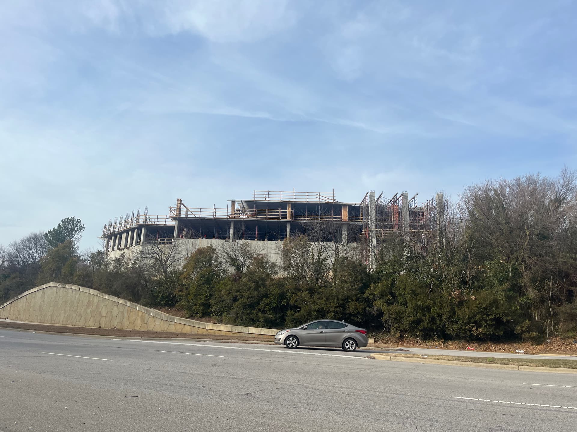
A new apartment building, named Mira Raleigh, is already constructing some future homes. It’s a tough location to photograph but you may have seen the building come up if driving down MLK. Here’s one photo, in addition to others, on the Community.
Rezoning case Z-088-22 has a majority of the property wanting to go taller. What’s also interesting is a separate subdivision case that may connect Kindley Street to MLK. The way I’m reading things, it actually looks like they own the northbound ramp from MLK to McDowell Street so I feel this may be removed if this new street configuration is put in place. I’m sure an alternate route will be put in place.
The rezoning case is still in the early stages and has yet to go before the planning commission. I’d like to think this is an easier rezoning to approve as no existing structures are impacted, there’s no traffic increase for anyone to complain about, and the location is very close to the downtown core.
If interested in this area, make sure to also check out nearby Salisbury Square.