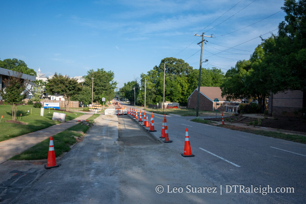
It certainly doesn’t look like a bus lane but if you squint, you can see the future dedicated lane along the southern side of New Bern being worked on. Actually, it’s all pipe work at the moment as workers replace an old waterline. It’s not transit but it makes sense to get that done so we can have stable road space for a high-frequency bus line in the near future.
I’m getting so bad at blog post titles these days. I really do apologize for that one.
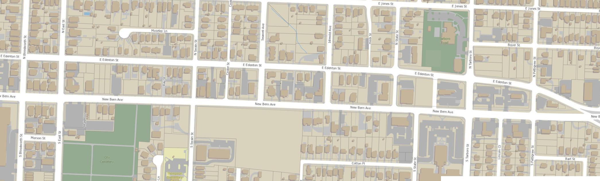
What I am getting better at is working with maps and data. It’s still a work in-progress but I wanted to put out this map, shown above, related to the currently proposed New Bern Station Area Plan. You can jump into this topic over at the city’s website as well as this post from Jan 2023.
I’m not sure anyone has actually said that quote but maybe someone should. (I’ll take it if it’s up for grabs) The folks I’m really hoping are saying this repeatedly is our own city as they continue to work through the planning efforts of the Bus Rapid Transit (BRT) system.
If you’re coming in fresh to the latest plans on the system then you can jump to the city’s website with an overview of the plans for the four corridors.
Now that it’s 2023, construction should begin on the first corridor of the BRT project. Throughout this year and next, dedicated bus lanes will be added, raised-platform, bus stations will be built, new sidewalks will be added, and traffic signals will be upgraded. We’ll be following along for sure.
What’s even more encouraging about all this are the efforts to slowly shift the dynamic of these BRT corridors by putting in place Transit-Overlay District zoning. It’s great to see the land use compliment the investments in transit.
I see it as a two-sided story. There’s the transit piece, buses, sidewalks, and roads, and then the land use piece requires more urban buildings delivering houses across the income spectrum, spaces for retail that residents can walk to, and office space for businesses. I see it as putting a mix of uses down a single street served by a faster and more reliable form of transportation.
The two stories for New Bern are summed up on these links and I encourage anyone reading to take a look:
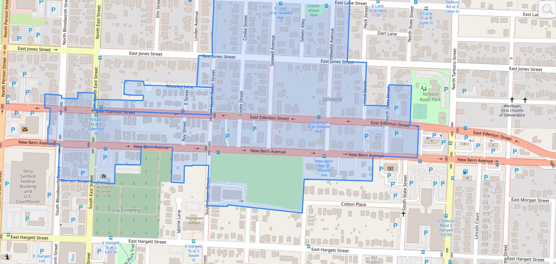
I also can’t help but highlight a great map. This one shows the proposed rezoning changes for the New Bern corridor so if you drive down that street or live near it, take a look.
The new BRT changes are coming and as mentioned earlier, construction will kick off this year. The rezoning application is in the final stages and when submitted will hit the Raleigh Planning Commission. I imagine it’ll be a much discussed topic throughout 2023.
For me, you can’t have the BRT running effectively without the right land use so I’m in full support of this rezoning plan. I’m sure there are edge cases that can be tweaked, and that’s fine as it’s a rezoning request across numerous properties, but without the planning piece put in place, I would be nervous about the BRT’s effectiveness for current and future residents in Raleigh.
We also can expect similar rezoning cases come out as the other three corridors mature and come close to their construction dates. BRT will be one of my “most watched” projects this year so I’ll leave this post right here with more thoughts and updates to come in the future.
The blog and Community tend to focus on new developments in the downtown core, such as 301 Hillsborough or The Willard hotel, that we may be overlooking some other activity just on the outskirts of downtown Raleigh. I thought it time for another Walk Series post to show off the east side of downtown, mainly the New Bern corridor.
The New Bern corridor interests me mainly due to some key observations and upcoming projects:
Planned location of the city’s first Bus-Rapid Transit route
Increased residential units from new townhome developments
Upcoming zoning conversations for the area
Loosely defined, for this Walk post, I’m focused on New Bern and Edenton Streets between Tarboro and East.
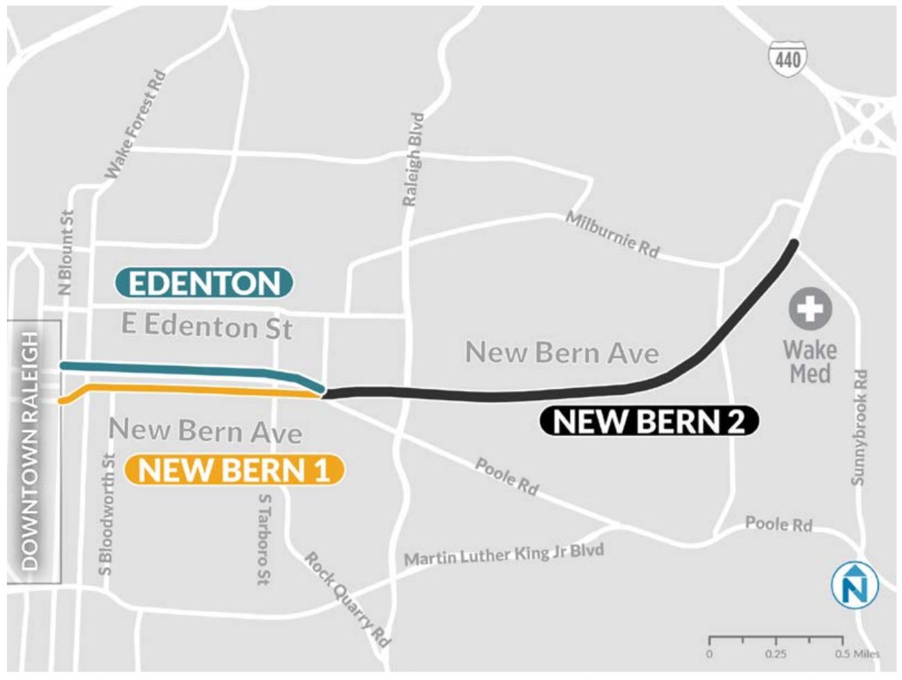
BRT Transit is Coming
With the implementation of the 1/2 cent sales tax for transit in 2017, higher-capacity transit, among other improvements, are being planned all over the county. Along New Bern and Edenton Streets, bus-rapid transit (BRT) will be rolling through in a few years if everything stays on schedule.
Being one of four planned BRT routes, high frequency transit will be flowing in and out of downtown Raleigh to the eastern parts of the county. Read more about the plan for BRT here.
The corridor may see dedicated bus lanes, expanded bike lanes, and new sidewalks on both sides of the street. It’s a big upgrade for the same corridor that currently runs the GoRaleigh bus route with the second highest ridership in that transit system.
Tarboro and New Bern/Edenton is loosely planned to get a BRT station on this upgraded route. The next stop inbound would be downtown itself.
Last reported, before the pandemic hit, plans were to be rolling buses in 2023-2024.
From Single-Family to Townhome
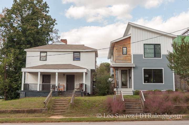
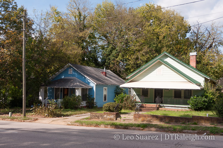
Historically, the corridor consists of many larger lots with single-family homes. You can still get a sense of the character going back to the early 1900s with the bungalows and larger houses facing the street.
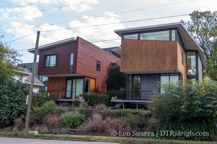
However, it’s not hard to spot some newer homes, mostly of modern architecture style, sprinkled throughout the area. These homes were popping up between about 2008 until today. These homes add a stark contrast to the area as you can see in the photos.
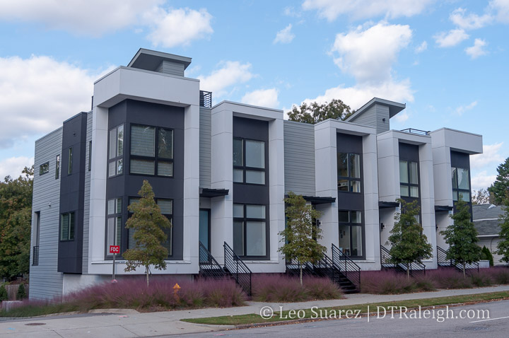
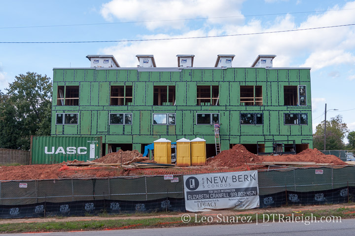
And if you really look more, the modern townhome seems to be making its way into the corridor as of recently. First, the ten-unit project named 10 Arros completed along New Bern within the last few years. Construction is currently taking place at 625 New Bern where 18 units are planned. Similar modern style as the former.
Finally, across the street from 625 New Bern is Oak City Overlook. This development plans 20 modern townhomes and land has already been cleared at the site.
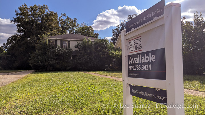
Could more be coming? I’ve seen plans submitted for more and you have for sale signs like this one at 914 New Bern which advertise, “Townhome/Condo Site for Sale.”
And there’s no shortage of space along this corridor. As I mentioned earlier, the single-family houses are on large lots that could easily be subdivided.
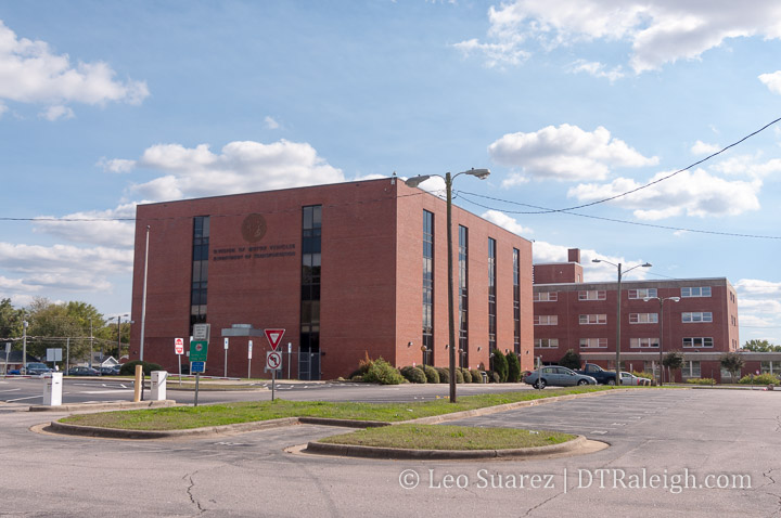
You also have the North Carolina State government vacating a large site at New Bern and Tarboro. The long-time site of the NC DMV is being vacated soon and that’ll put 5.4 acres of land a stone’s throw away from a rapid transit stop. Any development here, plus the adjacent surface parking that supported the NC DMV, could greatly change over if the state decides to sell it.
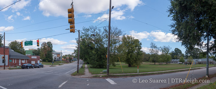
We also have 8 acres of undeveloped land at New Bern and Swain. Currently, the lot is only partially used by the Exploris school in temporary buildings but 8 acres offers a ton of flexibility, capable of a pretty transformative project. Just look at the map above, it’s that empty lot in the middle. That’s huge!
Zoning it Properly
From my perspective, you have two forces that are about to collide. The development is coming. Should transit only serve the single-family and new, high-end townhomes being built here?
To get more people access to the future transit network, an awkward conversation is soon to come, Raleigh. It’s time to talk about re-zoning the area.
This is a good time to revisit a collaborative post I did about a zoning tool called the Neighborhood Conservation Overlay District (NCOD) and it just so happens that this area has one right in the middle. Below is the New Bern – Edenton NCOD and you can see, almost everything mentioned so far sits right inside it.
In short, the NCOD applies additional restrictions on height, setbacks, and is a tool to encourage new development be consistent with the current character. This NCOD was put in place in 1992.
To make transit more effective, these townhome developments help but we’ll need some larger projects in here to ensure additional office and residential density as they will be within walking distance of a high-frequency bus stop. It is a prime opportunity to get Raleigh residents on a car-less lifestyle at a variety of income levels.
I feel that the NCOD implemented in 1992 needs a revisit and with the current talks of more affordable housing around transit, it would be better to deliver hundreds (thousands?) of new units here rather than status quo townhomes near transit.
The land is still available but the development is starting to pick up. I’m hoping the city can start purchasing land for affordable housing as well as pushing for new zoning updates to match our 2030 and beyond goals as a city.
More conversations on this topic are sure to come.
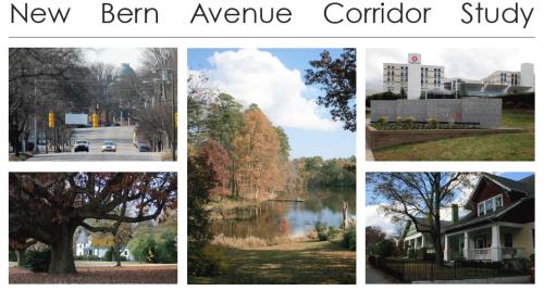
The New Bern Avenue Corridor study has been going on for over a year and the final draft report is now available. You can view it on the City of Raleigh’s study page here. The twenty-seven page pdf goes through all the issues of this corridor and lists recommended actions to take in order to improve the study area. The city is looking for comments about it so get them in before January 2. Here’s how.
Download the New Bern Corridor Study and send your comments to: dhanya.sandeep@raleighnc.gov
View the New Bern Corridor Study at the Planning Office and mail your comments to:
City of Raleigh
Planning & Development
P.O. Box 590
Raleigh, NC 27602
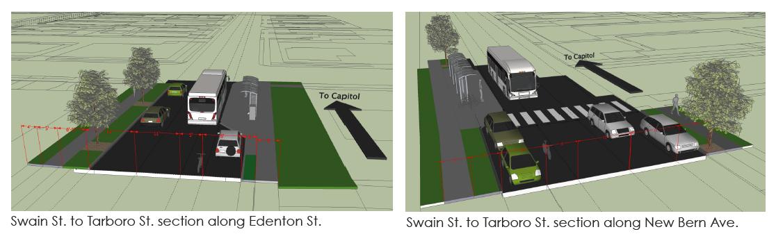
One piece of the corridor study that I commented on was the bicycle lanes. The study recommends a new street layout. Picture of that below.
Click for larger
The one-way streets of Edenton and New Bern are laid out, going left to right, with two vehicle lanes, a five foot bicycle lane, and an eight foot vehicle parking lane. The two way section of New Bern has a similar layout on both sides with a median in the center.
This layout irked me a bit after seeing it so after some thought I did some research and commented on the plan. Here is what I sent in:
“Hello, Dhanya.
Great work on the final draft of the study. I did want to pass along some comments of mine as I read through the report, specifically about the bicycle lanes.I hope that the city can consider an upgraded plan for cycling along this corridor to be implemented either with this New Bern vision or at some later time when funding becomes available.
The plan in the report shows that a cyclist can ride in a five foot wide travel lane with parked cars to the riders’ right and moving traffic to the riders’ left. In this layout, a cyclist is at risk of injury with cars entering/exiting parking spaces as well as at risk of being “doored” by unaware drivers exiting their vehicles. Buses will also stop within the bicycle lane in order to drop off and/or pick up new riders at bus stops. Since the New Bern Corridor has the highest ridership of any Capital Area Transit (CAT) bus, the chances for this to happen is high especially in the coming years if transit grows in Raleigh.
I propose the city consider an upgraded cycling transit plan for the New Bern Avenue Corridor where bicycles can flow with equal ease as nearby buses and cars on the road and pedestrians on the sidewalk. The five foot bicycle lane should be swapped with the eight foot car parking lane. The bicycle lane should then be protected with barriers so that cars cannot interfere with bicycle flow in that lane. A picture of what I mean can be seen here:
Protected bicycle lane in Chicago (via http://theexpiredmeter.com)
(full URL at http://theexpiredmeter.com/wp-content/uploads/2011/07/Protected-bike-lanes.jpg)
Clearly, other modifications are needed to make the bicycle lane flow smoothly through intersections and bus stops. The planned bus stop bump outs should then be modified into “island” platforms where waiting riders can step onto the bus at the same floor level. This helps the ease of entering/exiting passengers, especially wheelchair riders, and helps make any future bus rapid transit (BRT) or streetcar system flow much more smoothly. A picture of a bus platform with a bike lane around it can be seen here:
Bus platform with bike lane [Broken link] in Portland (via http://www.miabirk.com [Broken link])
(full URL at http://www.miabirk.com/blog/wp-content/uploads/2011/01/Platform-on-SW-Moody1.jpg [Broken link])
Regarding conflicts with bicycles crossing an intersection and vehicles making right turns, more research needs to be done on a way to have both parties yield correctly to avoid any nasty incidents. Other cities have found ways to accomplish this and I’m sure Raleigh can implement it as well.
I really think there is an opportunity for cycling in Raleigh to continue to grow with changes like these. If something like this existed from downtown all the way to WakeMed, a distance of three miles, then I think this corridor would be a truly mixed use transit corridor and spur lots of the great development that many participants in the study area asked for. This would allow for people to get around in many ways and helps preserve the neighborhood character on both sides by keeping the area at a more human scale.
Hope to see something like this in the future. Thanks a lot.
Leo Suarez”
So the dedicated bicycle lane in the recommended plan may not really improve things for cyclists then the current layout of New Bern Avenue and Edenton Streets. In my opinion, the current layout of three, and in some places four, travel lanes with no parking spaces allows a cyclist to move down the street more safely. Cyclists can travel with the curb to their right and plenty of space on their left for cars and buses to pass. The recommended layout with the bicycle lanes may force encounters between cyclists and cars parking as well as buses making their stops.
I think if Raleigh was really serious in building cycling infrastructure, the New Bern Avenue corridor needs more study on this topic. I hate to see similar problems in this area to the ones on Hillsborough Street’s bicycle lanes. If anyone has more knowledge on the topic, I’d love to hear your thoughts on this.