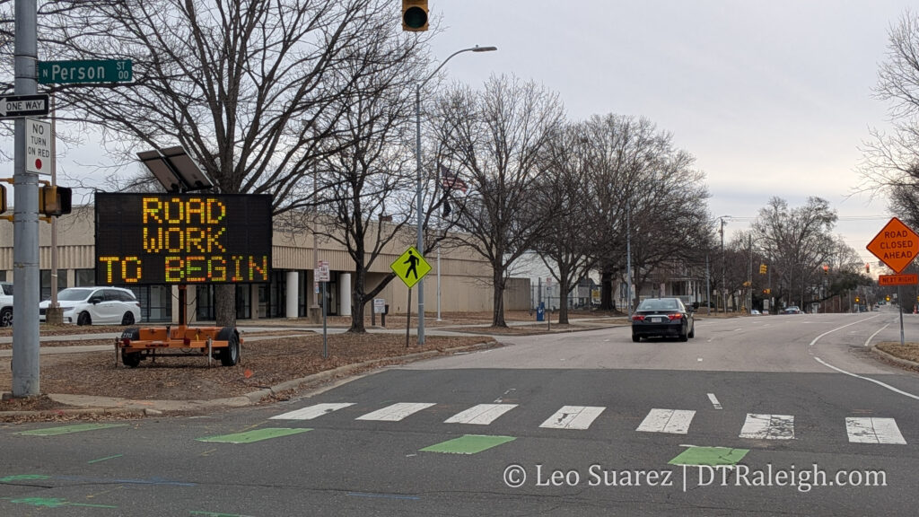
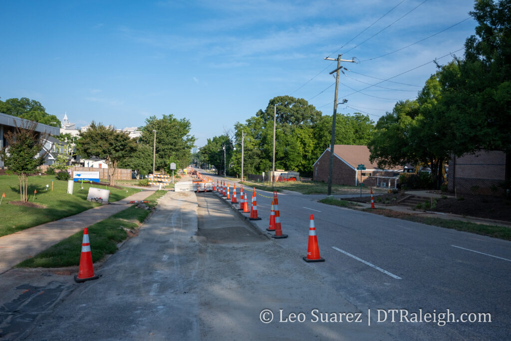
New Bern Transit-Oriented Development Plans Start To Move Forward

Above is the video for the March 5, 2024 City Council evening session where council revisits the topic of rezoning properties along New Bern Avenue in an attempt to support the now under construction Bus Rapid Transit route. It’s actually a more manageable 40 or so minutes to watch so I encourage anyone to check it out or watch it directly on YouTube here.

Continue reading →

2024 Will Be a Pivotal Year For Raleigh’s Transit Future. We Must Support Transit-Oriented Development.

In November 2023, the first of four bus-rapid transit (BRT) routes, years in the making, broke ground. The first route out the gate will be the eastern route. This one services the New Bern Avenue corridor between downtown, WakeMed, and parts around New Hope Road. We just might be riding around in articulated buses some time in 2025.

The increase in bus service is finally happening, kickstarted back in 2016, after Wake County voters decided to increase the sales tax in order to fund expanded transit. The second half of the transit journey comes with the accompanying land use and I think 2024 will be the year Transit-Oriented Development (TOD) becomes a household phrase. (or at least to all you readers out there)

Continue reading →

The Downtown North-South Greenway Connector Overview

I spent some time this week with a survey from the city about possible plans to reconfigure North West Street between Peace Street and Wade Avenue that could accommodate bike lanes, walking paths, and a different parking layout. If that excites you, jump right on over to that survey here to let them know what you think. If I still got you, I wanted to revisit the plans for more bicycle infrastructure along West Street, how it’s going, and what we might expect in the future.

Continue reading →

Volunteer Group Helps Make Downtown Raleigh Sidewalks More Accessible

lowered curb and crosswalk on city intersection
A crosswalk in downtown Raleigh

All throughout the cities of North Carolina and South Carolina, the development boom times have really kicked in within the last few decades. In most cases, this new growth in the South has led to car-centric development where driving a vehicle is almost required to navigate your city. For those able to drive safely, this has become part of Southern culture. However, not everyone can or wants to drive for their daily tasks. Our sidewalk networks, when present, pick up the slack here. For pedestrians with mobility challenges, high-quality sidewalks are a necessity.

Continue reading →

Mapping the New Bern TOD, NCODs, and HODs, Oh my!

I’m getting so bad at blog post titles these days. I really do apologize for that one.

What I am getting better at is working with maps and data. It’s still a work in-progress but I wanted to put out this map, shown above, related to the currently proposed New Bern Station Area Plan. You can jump into this topic over at the city’s website as well as this post from Jan 2023.

Continue reading →

New Bern Bus Rapid Transit and Upcoming Land Use Proposals

“With great transit comes great land usability.”

I’m not sure anyone has actually said that quote but maybe someone should. (I’ll take it if it’s up for grabs) The folks I’m really hoping are saying this repeatedly is our own city as they continue to work through the planning efforts of the Bus Rapid Transit (BRT) system.

If you’re coming in fresh to the latest plans on the system then you can jump to the city’s website with an overview of the plans for the four corridors.

Now that it’s 2023, construction should begin on the first corridor of the BRT project. Throughout this year and next, dedicated bus lanes will be added, raised-platform, bus stations will be built, new sidewalks will be added, and traffic signals will be upgraded. We’ll be following along for sure.

What’s even more encouraging about all this are the efforts to slowly shift the dynamic of these BRT corridors by putting in place Transit-Overlay District zoning. It’s great to see the land use compliment the investments in transit.

I see it as a two-sided story. There’s the transit piece, buses, sidewalks, and roads, and then the land use piece requires more urban buildings delivering houses across the income spectrum, spaces for retail that residents can walk to, and office space for businesses. I see it as putting a mix of uses down a single street served by a faster and more reliable form of transportation.

The two stories for New Bern are summed up on these links and I encourage anyone reading to take a look:

I also can’t help but highlight a great map. This one shows the proposed rezoning changes for the New Bern corridor so if you drive down that street or live near it, take a look.

The new BRT changes are coming and as mentioned earlier, construction will kick off this year. The rezoning application is in the final stages and when submitted will hit the Raleigh Planning Commission. I imagine it’ll be a much discussed topic throughout 2023.

For me, you can’t have the BRT running effectively without the right land use so I’m in full support of this rezoning plan. I’m sure there are edge cases that can be tweaked, and that’s fine as it’s a rezoning request across numerous properties, but without the planning piece put in place, I would be nervous about the BRT’s effectiveness for current and future residents in Raleigh.

We also can expect similar rezoning cases come out as the other three corridors mature and come close to their construction dates. BRT will be one of my “most watched” projects this year so I’ll leave this post right here with more thoughts and updates to come in the future.

Would you pay for parking if it meant you were always on time for lunch at The Village District?

Today, I have a guest post by a fellow Raleigh content creator. Jed Byrne loves Raleigh, especially its people and places. He tries to engage with both on a daily basis. Jed tweets about spaces and places at @Oakcitycre, hosts the Dirt NC podcast, and sends a weekly development newsletter through www.OakCityCRE.com. He always enjoys connecting with new people, so reach out on social or via email at oakcitycre@gmail.com.

For Raleigh to maintain and grow its reputation as a city of innovation, it’s important for us to experiment with dynamic parking pricing. I can think of no better place to pilot experimental parking than The Village District! But first, I think it’s important to share a bit of history.

If you have any questions about this post or have any Village District parking stories to share, hit me up on twitter at @OakCityCRE!

History of Innovation

The Village District has been an innovator since the beginning. Built in 1949, it was one of the first shopping centers in the country designed for the automobile age. In fact, the Village District was inspired by Country Club Plaza in Kansas City, the first center of its kind in the country!

Parking at The Village District

In all of my time here in Raleigh the congested parking situation at The Village District hasn’t kept people away. As Yogi Berra said “Nobody goes there anymore. It’s too crowded.”

In order to improve the shopping experience at the Village District and increase sales, there are really only two options that the landlord can control when it comes to parking. They can increase the number of parking spaces, or increase the number of people who use the existing spaces per hour.
It turns out that expanding the number of parking spaces at The Village District has already been tried. According to WRAL a parking deck lived at The Village District for 40 years!

The Original Parking Innovation

Originally built in the 1960s, the deck was demolished in 2005. You can see the original structure below in this satellite images from March 2002.

This image has an empty alt attribute; its file name is R21yYdP1d-wOhyUlZ_JmAHJLlMyakxUVll7Er7OpxxkQht7L6UCQCgBcz3x5yRi9S1U-G7a5WZEGz7JXdYr62N6kBy-XGufcy34IAaebookJ2TMsUwM6hlm-3bF_6Jr02_7dozJ7
Source: Google Earth

There was also a parking structure where the Berkshire Village District Apartments now stand at the corner of Oberlin Road and Clark Avenue. 

I couldn’t find many historical images of the parking deck, but my friend Ian Dunn shared the following photo from 1992 of the parking structure undergoing some demolition work.

NO_94411_Fr15 Cameron Village - From the N&O Negative Collection, State Archives of North Carolina. Photo copyrighted by the News and Observer. Illegal to use without express permission from the N&O.
Source:  NO_94411_Fr15 Cameron Village – From the N&O Negative Collection, State Archives of North Carolina. Photo copyrighted by the News and Observer. Illegal to use without express permission from the N&O.
NO_94411_Fr18 Cameron Village - From the N&O Negative Collection, State Archives of North Carolina. Photo copyrighted by the News and Observer. Illegal to use without express permission from the N&O.
Source: NO_94411_Fr18 Cameron Village – From the N&O Negative Collection, State Archives of North Carolina. Photo copyrighted by the News and Observer. Illegal to use without express permission from the N&O.

The demolition work above must have been for a modification because the second layer of parking stood for another 13 years.

In all my years of studying the built environment, this is the only case where I have heard of structured parking being removed from a project. From a practical standpoint, I am glad they removed the parking deck, though I never got to experience the deck first-hand. I think one of the main attractions to the Village District is the open air feel, which would have been hampered by structured parking. I am sure that the decision to remove parking wasn’t easy. Today a structured parking space costs $25,000-$35,000, roughly 5x the cost of a surface parking space.

Free Parking

Since adding supply didn’t make things better at The Village District, I think the time has finally come to address the congestion caused by “free” parking, once and for all. 

In the book The High Cost of Free Parking by Donald Shoup, you can learn all about how “free to you” parking spaces actually have a lot of costs. For starters, there are the indirect costs of construction and maintenance that are paid by the tenants. Those costs are ultimately passed through to the customers who must cover the cost of the tenants rent. 

There are also non-financial costs: the stress of congestion, the time and the environmental impacts of circling the lot looking for parking, and the induced demand for driving to shop in the first place.  

The costs of “free parking” are ultimately paid by all shoppers, whether they drive or not, and even whether they spend money at the shopping center or not.

Future Innovation

The Village District has been a place of innovation from the start. Its designers innovated what the shopping center looked like when they designed one of the first automobile-centric centers. Its owners innovated both by installing and ultimately demolishing the structured parking. I think it’s now time to innovate again. 

Using a platform like Passport, which is already used by the City of Raleigh, The Village District could start charging for parking in a way that ensured there would almost always be available spaces in the parking lot. Because parking demand changes over time, the Passport pricing structure could increase and decrease as well. At lunch, nights, weekends, and holidays, pricing would increase. 

These higher prices would encourage shoppers to only stay for the time they need to, and would also ensure that parking was always available. With more efficient use of parking and higher customer turnover the overall sales revenue would increase. Plus, if people knew they always had a place to park at The Village District, more people would come and shop!

So, what do you think? Would you pay – directly – to park at The Village District if it guaranteed you’d be able to find a spot quickly? I would!

Let me know what you think or share any Village District Parking stories by tweeting me at @OakCityCRE

Sources:

WRAL article  https://www.wral.com/news/local/story/114956/

Village District age: https://shopvillagedistrict.com/about/

Yogi Berra quote: https://www.brainyquote.com/quotes/yogi_berra_100418

A Visual Dive into the Towers at RUS Bus

I was feeling it for awhile now but I think it’s official. The developments planned for the Raleigh Union Station Bus Facility, RUS Bus as the cool kids are calling it, is now my favorite and most anticipated new development for downtown Raleigh. With some new renderings dropped at a recent meeting, I thought I’d post them here for us to go through.

RUS Bus will infuse a lot of new residents into the warehouse district with a residential tower and hotel. On the ground-floor, a bus station with retail just might elevate the area into a shopping district in the future. At least that’s what the optimist in me is hoping for.

While the Raleigh Union Station was very exciting (and still is!) to see build out, the rest of the station attaches a key piece of transit. For me, this just seems like the new center of town, the gateway to downtown Raleigh and for some, the entry-point to our city.

With that large plaza between the current train station and the bus station, there’s a lot of potential for it to a be a central spot, a meeting point, and even cultural center for our city. It’s very photogenic and has a sense of place. What’s missing right now are the sights and sounds of people!

And where are these people going to come from? We have apartments, a hotel, and lots of nearby restaurants and shops. In addition, the hustle of buses cruising in and out, dropping people off and on.

As a reminder, there are plans to also make this a stop on the future bus-rapid transit line. Easy way in and out from North Raleigh? That just might be it. Alternatively, the addition of more parking is fine plus The Dillon across the street has almost nine levels of parking.

It’s such a dramatic change from the warehouses we have on the site today. We may see the ground-breaking this year even. This one will be fun to watch.