Municipography, Union Station and Downtown Property Loans

Municipography is a summary of current issues going through the Raleigh City Council and other municipal departments in the city. The point is to try to deliver any video, photos, and text associated with the discussions happening at City Hall or elsewhere. Since this is a downtown Raleigh blog, the focus is on the center of the city.

The first Raleigh City Council meeting of 2012 was held yesterday. The proposed Union Station was discussed and the agenda describes it just as well as I can. From the January 3, 2012 agenda packet:

F. REPORT AND RECOMMENDATION OF THE PASSENGER RAIL TASK FORCE

1. NCDOT Concept for Raleigh Rail Station

At their December 12, 2011 meeting, the Passenger Rail Task Force discussed proposed improvements to the Dillon Viaduct Building by NCDOT to convert the facility to a passenger rail station. The new station would replace the existing train station on West Cabarrus Street and would accommodate existing Amtrak service, proposed future high-speed rail service, and the proposed future Triangle Transit commuter rail service. The passenger rail station would be the first phase of a larger Union Station multimodal facility that would also provide service to local bus, regional bus, and light rail services. City staff will continue to work on conceptual designs for future phases of the Union Station multimodal facility.

After reviewing draft concept plans presented by the NCDOT Rail Division, the Task Force voted unanimously to recommend endorsing the proposed Viaduct Building rail station retrofit concept. A complete copy of their evaluation is included in the agenda packet. $3 million has been appropriated for City participation in the cost of this facility
as part of the 2011 Transportation Bond and will be available in FY13 in the draft Capital Improvement Program.

Recommendation: Endorse the findings of the Passenger Rail Task Force to retrofit the
Dillon Viaduct Building for use as the rail station of Union Station.

The council voted unanimously to endorse this site and the plans recommended by the Passenger Rail Task Force. Watch the video below for more discussion about it during the meeting.

A great pdf document that goes over the concept of turning the Dillon Viaduct building into a train station is “NCDOT Viaduct Building Assessment”, taken from the Passenger Rail Task Force webpage on the city’s website. You can download it here. In this document, you can see the phased approach to adding new platforms for Amtrak, commuter rail, and high-speed rail to the Boylan Wye as well as other additions to accommodate the station.

Downtown Loan Program

The Downtown Loan Program was created for properties along Fayetteville Street, typically older structures, to be brought up to proper code for owners and potential tenants. This was an effort to help bring businesses to the Fayetteville Street area after it’s renovation a few years ago. The loan program is now being expanded to more streets in downtown Raleigh. From the City of Raleigh’s press release, the streets include:

The program will include portions of Dawson Street, Glenwood Avenue, Hargett Street, Martin Street, Davie Street, Fayetteville Street, Blount Street, Person Street and designated at primary retail Street in the Comprehensive Plan. Designated secondary retail streets include portions of Harrington Street, West Street, McDowell Street, Dawson Street, Salisbury Street, Wilmington Street, West Morgan Street, Hillsborough Street and Peace Street.

And finally more about the program:

The program is designed to create an incentive to new and/or expanding Downtown businesses and commercial property owners seeking to improve properties. To be eligible for the loan program commercial property owners and business owners must demonstrate management ability and experience. Qualified applicants must show they are unable to secure financing from financial institutions for the amount being requested from this program. To date the program has made three loans to area businesses. One of the loans has been fully repaid. Currently $200,000 is available.

The expansion was approved by the council during the consent agenda.

Downtown Raleigh 2011 In Review

Tubes of Light by dtraleigh, on Flickr

2011, what will we remember you by? All-star weekend or Hopscotch 2? Could the food truck saga of this year be the one that sticks out in your mind? Or perhaps, if affected, you may still be dealing with damage from the April tornadoes?

On planning downtown Raleigh, this past year has been pretty active with long range plans becoming more detailed, less alternatives, and more decisions. Missing was another Raleigh Wide Open but there were plenty of events that kept spirits high. One of the biggest feather in downtown’s hosting cap was the 2011 NHL All-Star game, bringing a new format from years past and was reviewed very positively across the hockey world.

As always let’s first start with the 2011 wishlist. This list only consists of items that can be done in one year’s time.

  • Bookstore
  • More Hours
  • Counter Service Food
  • Food Markets
  • Mass Transit Plan

For a second year in a row, a bookstore has not happened. Reading articles about Amazon selling a million Kindles a week this holiday season really isn’t helping new bookstores open especially an independent store in a relatively low traffic, downtown area. Probably the best thing is for downtown residents and workers to support the Wake County express library on Fayetteville Street. The library is open Monday to Friday from 10am to 6pm so if you can work it into your schedule, give this location a shot.

I feel some businesses have tried to expand their operating hours this year. I didn’t keep track of this one very well so correct me if I’m wrong. A few examples that I can think of are The Pit opening on Sundays, Wilmoore Cafe having weekend hours, Poole’s Diner opening on Tuesday nights, and Mecca adding some hours as well. The wish really is to get to the point where downtown Raleigh is “open for business” at all times of the day and night so that people feel there are several options available to them. This pushes the 24/7 idea closer to reality.

Counter service food options are still out on the horizon. Chuck’s attempted counter service but later changed it due to requests. Perhaps more residents in the area will help expand the quick and cheap eats category options.

The downtown Farmer’s Market continued to serve up City Plaza each Wednesday this year during the warmer months, just like the last one. This is probably the closest thing to market style food buying that we’re going to get for awhile. There is however a produce shop over in City Market that a lot of people don’t know about. Walk over there and give them a try if you are into Farmer’s Markets.

There was plenty of transit talk this year and plans are taking steps forward. In light-rail news, the city picked their preferred alternative which involves a light-rail line to enter downtown from the west on Morgan Street and hang a left on to Harrington Street to exit downtown to the north. A comprehensive bus plan has also been released with plans to significantly expand bus service around Raleigh and the rest of the Triangle. High-speed rail is also moving along with a new plan to bridge the trains over Capital Boulevard into Glenwood South as they head for Union Station in the warehouse district.

Construction in 2011

New building construction moved along in 2011 with projects continuing to take shape or break ground. Here is a list of construction projects we’ve been following all year.

  • The American Institute of Architects North Carolina building on Peace Street has finished, or is close to finishing, up now as we close out the year.
  • The Wake County Justice Center started the year as a formation of steel beams in the ground. The construction project will go into 2012, topped off and mostly covered up. County officials have also let everyone know that this project came in under budget.
  • The Green Square project has partially finished with the rest set to open in April 2012. The Department of Environment and Natural Resources offices are fully open as well as the parking deck across the street. The Nature Research Center, with it’s eye catching globe at the corner of Salisbury and Jones Street, will open in 2012.
  • Glenwood South’s first hotel, a Hampton Inn, has broken ground at the corner of Glenwood Avenue and Johnson Street.
  • The North Carolina State Bar has started construction on their new headquarters at the corner of Edenton and Blount Street.
  • All year we’ve watched the State Employees Credit Union building on Salisbury Street rise up and peak at about twelve floors. Glass is being installed on the building now and construction will continue into 2012.

Go here for a gallery of renderings of SECU and Green Square.

Other highlights of 2011:

  • Numerous electric vehicle chargers have been installed around the city with several in close proximity in downtown.
  • A large scale development project, The Edison, has scaled down tremendously.
  • The still empty lot where The L Building is planned now contains attractive banners to cover up the gray wall of the parking deck.

New Bern Avenue Corridor Study Comments and Bicycle Lanes

The New Bern Avenue Corridor study has been going on for over a year and the final draft report is now available. You can view it on the City of Raleigh’s study page here. The twenty-seven page pdf goes through all the issues of this corridor and lists recommended actions to take in order to improve the study area. The city is looking for comments about it so get them in before January 2. Here’s how.

  • Download the New Bern Corridor Study and send your comments to: dhanya.sandeep@raleighnc.gov
  • View the New Bern Corridor Study at the Planning Office and mail your comments to:

    City of Raleigh
    Planning & Development
    P.O. Box 590
    Raleigh, NC 27602

One piece of the corridor study that I commented on was the bicycle lanes. The study recommends a new street layout. Picture of that below.


Click for larger

The one-way streets of Edenton and New Bern are laid out, going left to right, with two vehicle lanes, a five foot bicycle lane, and an eight foot vehicle parking lane. The two way section of New Bern has a similar layout on both sides with a median in the center.

This layout irked me a bit after seeing it so after some thought I did some research and commented on the plan. Here is what I sent in:

“Hello, Dhanya.

Great work on the final draft of the study. I did want to pass along some comments of mine as I read through the report, specifically about the bicycle lanes.I hope that the city can consider an upgraded plan for cycling along this corridor to be implemented either with this New Bern vision or at some later time when funding becomes available.

The plan in the report shows that a cyclist can ride in a five foot wide travel lane with parked cars to the riders’ right and moving traffic to the riders’ left. In this layout, a cyclist is at risk of injury with cars entering/exiting parking spaces as well as at risk of being “doored” by unaware drivers exiting their vehicles. Buses will also stop within the bicycle lane in order to drop off and/or pick up new riders at bus stops. Since the New Bern Corridor has the highest ridership of any Capital Area Transit (CAT) bus, the chances for this to happen is high especially in the coming years if transit grows in Raleigh.

I propose the city consider an upgraded cycling transit plan for the New Bern Avenue Corridor where bicycles can flow with equal ease as nearby buses and cars on the road and pedestrians on the sidewalk. The five foot bicycle lane should be swapped with the eight foot car parking lane. The bicycle lane should then be protected with barriers so that cars cannot interfere with bicycle flow in that lane. A picture of what I mean can be seen here:

Protected bicycle lane in Chicago (via http://theexpiredmeter.com)
(full URL at http://theexpiredmeter.com/wp-content/uploads/2011/07/Protected-bike-lanes.jpg)

Clearly, other modifications are needed to make the bicycle lane flow smoothly through intersections and bus stops. The planned bus stop bump outs should then be modified into “island” platforms where waiting riders can step onto the bus at the same floor level. This helps the ease of entering/exiting passengers, especially wheelchair riders, and helps make any future bus rapid transit (BRT) or streetcar system flow much more smoothly. A picture of a bus platform with a bike lane around it can be seen here:

Bus platform with bike lane [Broken link] in Portland (via http://www.miabirk.com [Broken link])
(full URL at http://www.miabirk.com/blog/wp-content/uploads/2011/01/Platform-on-SW-Moody1.jpg [Broken link])

Regarding conflicts with bicycles crossing an intersection and vehicles making right turns, more research needs to be done on a way to have both parties yield correctly to avoid any nasty incidents. Other cities have found ways to accomplish this and I’m sure Raleigh can implement it as well.

I really think there is an opportunity for cycling in Raleigh to continue to grow with changes like these. If something like this existed from downtown all the way to WakeMed, a distance of three miles, then I think this corridor would be a truly mixed use transit corridor and spur lots of the great development that many participants in the study area asked for. This would allow for people to get around in many ways and helps preserve the neighborhood character on both sides by keeping the area at a more human scale.

Hope to see something like this in the future. Thanks a lot.

Leo Suarez”

So the dedicated bicycle lane in the recommended plan may not really improve things for cyclists then the current layout of New Bern Avenue and Edenton Streets. In my opinion, the current layout of three, and in some places four, travel lanes with no parking spaces allows a cyclist to move down the street more safely. Cyclists can travel with the curb to their right and plenty of space on their left for cars and buses to pass. The recommended layout with the bicycle lanes may force encounters between cyclists and cars parking as well as buses making their stops.

I think if Raleigh was really serious in building cycling infrastructure, the New Bern Avenue corridor needs more study on this topic. I hate to see similar problems in this area to the ones on Hillsborough Street’s bicycle lanes. If anyone has more knowledge on the topic, I’d love to hear your thoughts on this.

Raising The Bar In Downtown Raleigh

As most of you know, the blog has been down for a few weeks as I was out of the country in Australia. The trip was all vacation but it was hard to turn off the thinking cap when we stumbled across something cool in the urban areas of the country. Every now and then, I thought about how things I saw over there could work in Raleigh.

We did see the wildlife and The Outback of the country during our time but the cities are what I want to mention here in this post. By no means am I saying that Australian cities are the shining example to copy. I admire some of the city aspects that have led to an urban environment that I think most readers want for downtown Raleigh.

Everyone agrees that Raleigh is growing and we will continue to grow for the near future. So what kind of city do we want to become?

There were a few aspects of these Australian cities, all larger than what Raleigh is now, that we could grow into but the planning for it has to start now. Urban parks, pedestrian amenities and historic preservation are just a few examples of things that had to start somewhere and over time, they have really elevated these cities in terms of livability and overall ‘interestingness’.

Here are a few points that I feel Raleigh needs to plan or do today in order to help foster urban growth in the future.

Protect Open Spaces
While visiting the city of Perth, I was very impressed with Kings Park. This 1,003 acre park sits on a hill overlooking the Swan River and is a short walk from the city’s core business district. (CBD) The park has been open since 1895 and today two-thirds of it are natural and untouched. Outdoor events take place at the botanic gardens and citizens of Perth just enjoy the open space. The big sell is the amazing view of the Perth skyline and the Swan River right from the park.

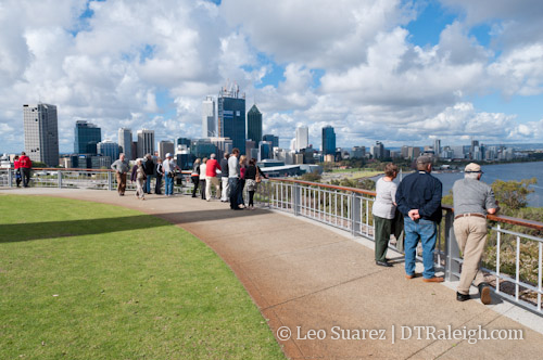
I immediately thought about Raleigh’s Dorothea Dix campus and the Dix 306 effort to make it a park. Kings Park was planned to stay undeveloped over 100 years ago and over time, the park is a jewel for the city. Raleigh should follow this same path.

After taking a look at some maps, Perth’s Kings Park is pretty much the same distance to its CBD as the Dix campus is to Raleigh’s CBD. What a huge opportunity for the city and downtown will benefit immensely. We should preserve all 306 acres of the land, no less. I look at the current city council for getting this done. If you support this effort, please make more noise for it.

A City For People
From my point of view, I felt like the cities were built like the ones here in the states. Downtowns, or city centers as they are more commonly referred to, is where the density starts. The center is surrounded by urban neighborhoods and as you continue out the suburbs fill in. The difference, however, is how the cities are well connected with trains, long distance bicycle lanes and other transit for people to get around with. It’s just woven into the culture there.

Raleigh is taking steps towards updating it’s transit but there are smaller steps that can be done to show that the pedestrian is the most important life form in our urban areas. Sidewalks that are wide, maintained, and on both sides of the street are important. The comprehensive plan and the Unified Development Ordinance are helping push wider sidewalks and bicycle amenities into downtown so we may be at the beginning of this change.

Australian cities also use lots of awnings on buildings, similar to the one over the entrance of the Sir Walter Apartments building, providing shelter against the rain. I’m sure the appearance would really irk some people but they are very functional and kept the sidewalks crawling with people even in the rain. And it’s not a new concept for Raleigh at all. Take a look at some historic photos and you’ll see downtown with lots of them hovering over the sidewalks.

In some areas of the cities, crosswalk signs operate slightly different. As a pedestrian, when crossing a one-way street, the walk signal would turn from ‘Do not Walk’ to ‘Walk’ about three seconds before the car traffic light turns green. This helped put pedestrians out in the street so cars are made aware of them. I feel something like this could be done on the busy streets of McDowell and Dawson.

An example would be with a car waiting to turn right onto McDowell Street with a pedestrian waiting to cross at the corner which is to the car’s right. Currently, the traffic and pedestrian light turn green at the same time and anxious drivers sometimes cut off the ‘slow’ moving pedestrian. This leads to close encounters with an exchange of short words and a finger. (I’ve seen it and have done it) But if the pedestrian signal turned ‘green’ three seconds before the traffic light, then the waiting pedestrian would probably be in the middle of the intersection when the car wants to turn. This makes the pedestrian more visible and there’s less of a wait for the car, while the light is green.

Come to think of it, Wilmington and Hargett Street need this as buses taking right turns onto Wilmington Street are not too considerate in some cases to pedestrians crossing in front of them. It sounds like a small change but I feel those tiny details make a difference for the sidewalk experience.

Protect History
This is a tough one. Where can we draw the line on historic preservation? What should be saved and what can we live without? The way I see it, Raleigh’s historic building stock is pretty low so only saving buildings on the scale of Briggs Hardware is too weak in my opinion.

Renovation and re-use should be encouraged and it’s happening today in some areas but not on a large enough scale. As our historic buildings are torn down, including the ones with no architectural contribution, structural reminders of Raleigh’s past are now only kept in photos and memories. More people should realize that we live in an age where things are built with the bottom line being the most important element during construction. This leads to generic and uninteresting structures that are going to look the same from city to city. If all the historic buildings are gone, what differentiates Raleigh than any other city that has torn down it’s past? I think this needs to be worked on in the near future as shorter buildings in downtown and the warehouse district may come down in name of progress.

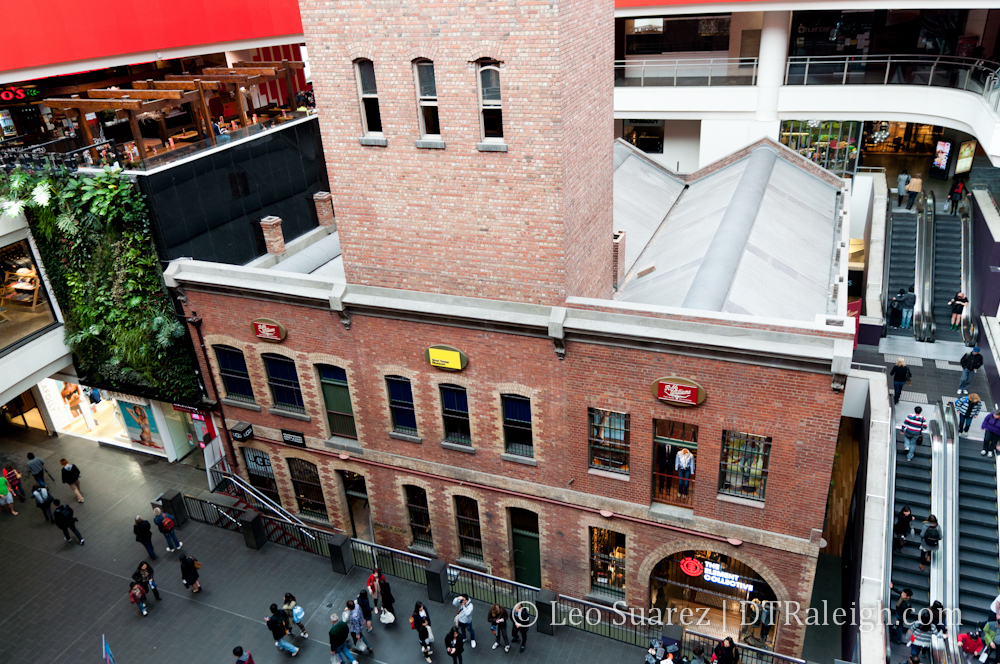
An extreme example of historic preservation in Australia I want to share was the way the city of Melbourne held onto a lead pipe and shot factory, the fifty meter tower of it being the tallest structure in the city for a few decades. Actually, you may not call this historic preservation but I’ll let you decide.

The Melbourne Central train station was built under the shot factory with a five story mall with movie theater above ground. The shot tower still sits in the central indoor plaza of the mall with a tall glass cone encasing the plaza and the tower as well. The tower now has a small museum and was renovated as store space for the mall.

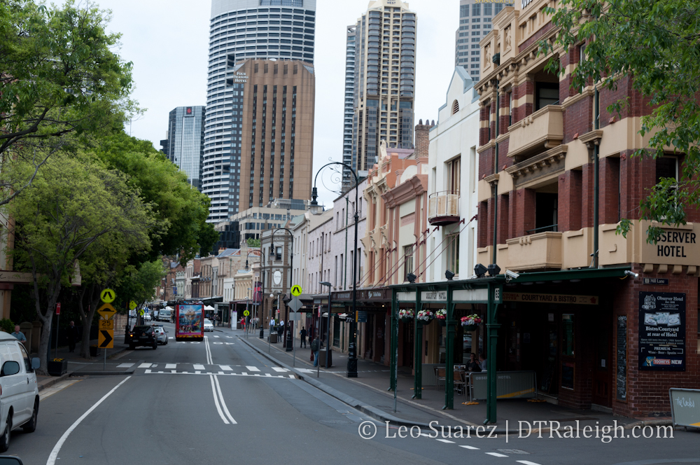
Don’t Be Scared of Giants
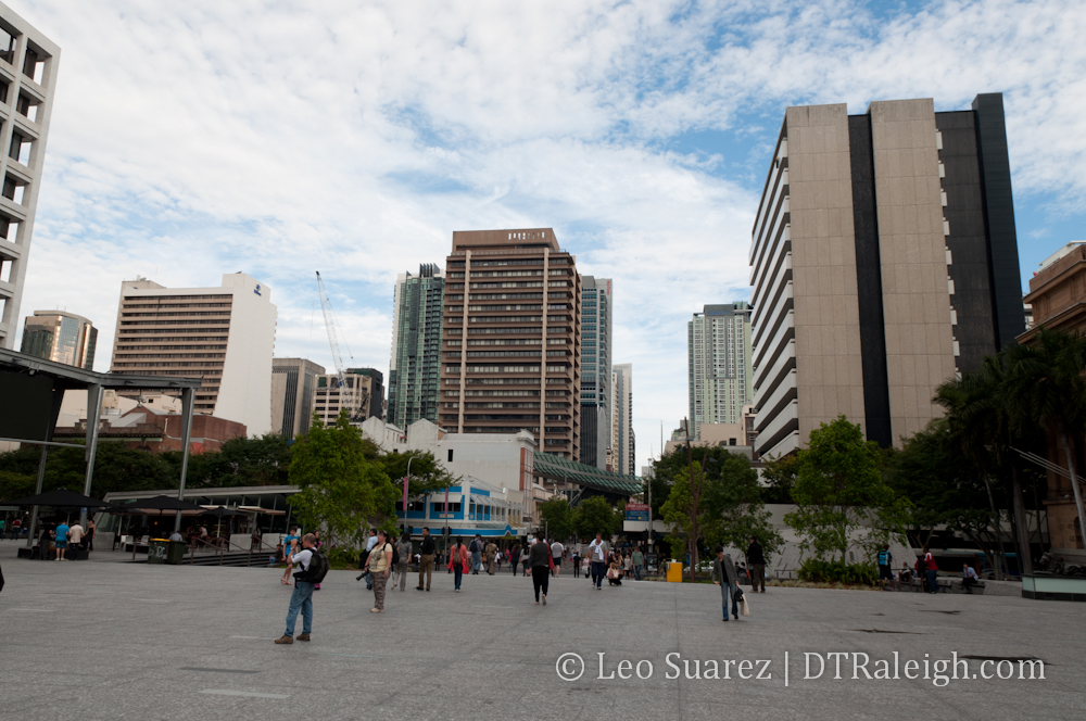
As a followup to the protect history section, I think that we shouldn’t feel scared to build tall next to a short building. Maybe I’m in the minority here but as a pedestrian I see nothing wrong with a three story historic building up against a skyscraper. From afar, sure it may look a little strange but walking around Lang Park in Sydney, there were quite a few examples of old shorties next to giants.

Lang Park is near the area of Sydney called ‘The Rocks’, the site of the original settlement near the water. Since it’s old, almost all of the buildings are two or three stories tall. There is an interesting transition from The Rocks up towards the CBD, where the skyscrapers tower over the history and in some cases are right up against them. It’s tough to describe without seeing it but it really wasn’t a big deal. Trees, which are awesome anyway, helped block out the skyscraper in some cases from a sidewalk point of view and it didn’t matter. If you explore the area on Google, you can see what I mean.

Think about this the next time you walk down the sidewalk in downtown Raleigh. How many floors are you really paying attention to right next to you?
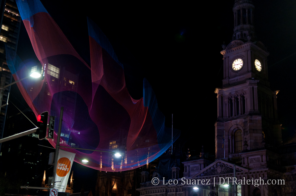
Public Art Aplenty
This one should be easy for Raleigh. Public art seemed to be everywhere and with great open spaces and pedestrian plazas, the art was the final touch to making the experience more enjoyable. First Friday, Sparkcon, and Artsplosure are just some of the few arts events that take place in downtown that push the arts. But they are still events that end and come back later. More public art installations around downtown will let people know that this is an interesting area to be.

As with any trip, the new experiences just flood me with new ideas. The other cities that are doing some of the things we talk about and plan are now doing it successfully. With more people moving here, downtown Raleigh must accommodate the growth along with the rest of the city. There’s no standing still I feel. We just need to walk the walk and get to that next step or else Raleigh will fall into the category of generic city, USA.

High Speed Rail Adds NC5 Alternative, More Massive Maps No Monitor Can Handle

High speed rail talk is back! It has been just over a year since the last major update on the plans to run high speed rail from Raleigh to Richmond, Va. This time, a new alternative has been released, called the NC5 alternative, and SEHSR.org has a massive map that you can download to see this proposal.

First, let me plug the meeting about this update.

The public is invited to attend a Project Update Meeting to learn about a new rail alternative developed for the SEHSR [Southeast High Speed Rail] corridor in downtown Raleigh, NC. The meeting will be held Tuesday, Sept. 27, 2011, from 4 to 7 p.m. at the Raleigh Convention Center.

For some history on the project, you can dive into the older RalCon posts here. The short of the story is that in the summer of 2010, three plans were on the table for the portion of the rail line running from Whitaker Mill Road to the future station in Downtown Raleigh’s Boylan Wye. Comments from all three plans were taken in and now a fourth alternative is on the table. By the way for the mathematically gifted, an NC4 alternative was a real idea last year but didn’t gain much ground, hence the NC5 naming of this recent one.

The SEHSR site introduces this new alternative nicely:

Alternative NC5 was developed in response to strong public opposition to Alternative NC3, as well as to the City of Raleigh’s opposition to the disruption of traffic and pedestrian patterns in the area around Jones Street and Glenwood South presented by Alternatives NC1 and NC2. It was also developed to minimize impacts to the freight operations within the Norfolk Southern and CSX rail yards. Last, Alternative NC5 was developed to avoid impacts to historic resources listed in or eligible for the National Register of Historic Places. Along with the development of Alternative NC5, revisions have been made to Alternatives NC1, NC2, and NC3 based on comments on the DEIS. All alternatives have removed the bridge on Hargett Street over the railroad, and would instead close the Hargett Street railroad crossing. In addition, a pedestrian bridge along Jones Street over the railroad corridor was added to Alternative NC3 (as well as the new Alternative NC5) to mitigate the effects of the road closure.

If you want, you can download the pdf in its original form at this link, taken right off the SEHSR site.

However, if you happen to like maps that have north pointing straight up, like I do, I have cut, copied and rotated the same version with north pointing towards the top of your monitor. For smaller viewing, I’ve also included key sections of the map that show the major changes.

Rotated NC5 map full map (3605×4274)
Whitaker Mill elevated bridge (600×500)
Wade Avenue and bridge over Capital and West (600×500)
Jones Street pedestrian bridge (600×500)

UPDATE: 09-18-11

Steven Waters has made a mash up of the NC5 alternative and Google Maps. See the overlay at this link.

Walking Riding through NC5

Let me attempt to talk you through this route. Place yourself on Whitaker Mill road where it crosses the tracks between Wake Forest Road and Atlantic Avenue. This fictional train I’m putting you on is facing south and will be heading into downtown Raleigh.

The first change is that Whitaker Mill Road will go over the tracks. Not such a shocking change as all the alternatives propose this. It’s a requirement that high speed rail operate on dedicated tracks and not share with street traffic.

Next, starts the controversy that we went through last year. As the tracks move south to Capital Boulevard, there is a crossing between tracks owned by CSX and others owned by Norfolk-Southern. Should the high speed trains follow the CSX corridor or the Norfolk-Southern?

Under NC5, the high speed train continues south and will stay on the CSX train corridor, which are the set of tracks east of Capital Boulevard. This avoids the Norfolk-Southern railyard on the west side of Capital, something that they greatly opposed.

As the train moves southward, the next interesting piece comes around the Wade Avenue flyover. A bridge will be built over Capital and West Street allowing the trains to come out of the CSX corridor and then enter the Norfolk-Southern corridor on the west side of Capital.

The train then continues on into downtown to the future Union Station.

Now I mentioned earlier that streets must be closed for high speed rail and in Glenwood South, Jones Street is the only street where the train crosses at the same level of the tracks so by this rule, Jones would have to be closed at this point. That is the case here. Under NC5, Jones Street will be closed to vehicular traffic. However, the alternative includes a pedestrian bridge over the tracks where the other alternatives did not include that before.

A very interesting plan for sure. The pedestrian bridge over the tracks on Jones Street is a huge plus for downtown and I’m glad the idea of the elevated bridge for vehicles was essentially thrown out. With an ongoing Capital Boulevard corridor study going on, I wonder if this bridge over it will mesh well with a new corridor vision.

Enjoy the maps and provide your comments before October 27th.

Municipography, Food Trucks Approved in Downtown Raleigh

Municipography is a summary of current issues going through the Raleigh City Council and other municipal departments in the city. The point is to try to deliver any video, photos, and text associated with the discussions happening at City Hall or elsewhere. Since this is a downtown Raleigh blog, the focus is on the center of the city.

Food Trucks Approved With A 6-2 Vote

The Raleigh City Council has now approved the operation of food trucks in the city with a list of restrictions. Councilor Mary-Ann Baldwin presented the issue as it left last week’s Law and Public Safety Committee but proposing an amendment to change the 1am time limit back to 3am. The reasoning was to be more consistent with the push carts that currently are allowed to sell food until 3am. A list of some of the major rules are:

  • Food trucks are allowed on private property only, no public right of way unless it’s a special event.
  • A 10pm time limit is in effect when around residential areas.
  • A food truck maximum is three per one acre lot or larger. It’s less with smaller lots.
  • A lot permit ($74) and a food truck permit ($150) must be obtained from the lot owner and food truck owner each year.
  • Ordinance goes into effect on October 1st, 2011 to allow time to create a manual for those seeking the permits.

Councilor Baldwin also proposed that at six months, a report be presented to the council about how the food trucks are doing in the city, any violations and/or any enforcement issues. Councilor Eugene Weeks and Councilor Russ Stephenson spoke up supporting the changes and the six month report.

The strongest opponent to the food trucks was Councilor John Odom, speaking up with an apprehensive tone and claiming that, “I think we’re moving to fast.” He even brought a slight reaction from the crowd after ending his talk with, “I’m not looking forward to being like Durham I’ll tell you that.” (12:32 in the video above)

Outside of the obvious inappropriate and incorrect comment from Councilor Odom, (embarrassing) I’m glad we are moving forward on the food truck issue as we can now put this behind us. I’m still worried about the handling of this issue and some members of the council may not be ready when true innovative ideas present themselves in Raleigh. Will Raleigh welcome innovation or strangle it with restrictions? This topic may be looked at further in a future blog post.

The Food Truck Placement Issue Visualized and Mapped


Map of downtown Raleigh with surface lots is an academic project created by the Downtown Living Advocates’ Streetscape Committee and Andrew Campbell of NC State.
Click the image for large or here for a full size.

In case you haven’t been following closely, the last time the food truck issue has been looked at by the city was at the Law and Public Safety Committee’s July 26th meeting. (meeting minutes here) No recommendation was made by that committee and it will next be discussed at their August 30th meeting. Once they make a recommendation it goes to the city council where they can approve it or pass it along for more review.

One of the restrictions that is being discussed is for the food trucks to be no less than 100 feet away from a restaurant’s front door. This restriction probably comes from a few restaurant owners that are against food trucks in downtown Raleigh. While I don’t agree with some of the arguments made by these owners, I feel there is a way to compromise in order for us to finally have the food trucks up and running.

I’ve modified a map of downtown Raleigh in an attempt to visualize what the 100 foot rule may look like. The map above shows a few things.

  • The purple area is Downtown Raleigh
  • The yellow areas show surface parking lots
  • The red areas represent where a food truck cannot operate under the 100 foot rule. These are 100 foot radius circles with the center being over a restaurant’s front door

The red areas’ locations are approximate and not every downtown restaurant is shown on the map, rather a majority is represented as I can still make my point with a few missing. Click on the image above to see a larger view or the link below it for a full size image for larger screens.

The Compromise

First off, I think the map is pretty powerful in showing the amount of surface parking we have in downtown Raleigh. I’d love to dive into this topic but I’m going to save it for another time. Instead, the point of overlaying the surface parking with the red circles shows us something else completely. There is a perfect opportunity, in my opinion, to have this food truck issue closed and all businesses can operate fairly.

The 100 foot rule is perfectly adequate to give the restaurants some breathing room from the trucks they are against. If you look at the map, the two sections of downtown with the most activity, Glenwood South and Fayetteville Street, are naturally buffered from any available spaces for food trucks to park. Restaurants claim it is unfair competition since they pay high rent and more overhead. The way I see it, those higher rents are getting these restaurants prime lots in downtown, which the food trucks can’t park in with this 100 foot rule.

With the map above, you can also see which areas have no food at all, mainly the government district north of the State Capitol. Food trucks can then provide a convenient service to a workforce that currently drives to get their lunches if they didn’t bring it with them.

The next issue that has been brought up is the affect of food trucks on traffic flow. The high amount of surface parking presents an opportunity for re-use and for us to energize these static, barren spaces. Food trucks can be kept off streets and parked on lots rather than in parallel parking spaces. They bring people to them and therefore the lots will have a new type of use by the pedestrian that it hasn’t had before. Collaboration between private lot owners, public lots and food trucks owners can work out a system, perhaps in the permit which they need to pay for anyway, so that certain spaces are designated for the trucks. Imagine private lot owners competing for food trucks to park in their lots because it gives them more exposure and more regular parking revenue from the trucks. It may just encourage some to clean up those desolate looking lots.

Some more official form of this map may end up being made by the city, as they are discussing perhaps raising the distance to 150 feet. According to the minutes of the July 26th Law and Public Safety meeting:

Chairman Baldwin asked:

7. What are the implications of an increase in the distance requirement from 100 to 150 feet?

Senior Planner Crane stated it is another 50 feet of distance. This was sorted out at the public hearing in April. He pointed out if you take this question with question #8 what are the implications of an increase in the distance requirement from residential areas to 200 feet? You will find along very narrow corridors like Glenwood South they will have a much smaller narrower area to locate these food trucks.

Assistant City Manger Howe stated they have not done enough specific analysis to see exactly how many spaces this may allow. It is possible to do this but would take some time. Ms. Baldwin asked how long it would take to do an analysis. Mr. Crane stated they would need a week to ten days. Mr. Howe stated they would still have to identify where the door is. A lot of the work can be done on GIS but you cannot tell on GIS where the door is. The group discussed this issue extensively as it relates to distance, mistakes that could be made, area sizes, doorway identification, industrial zoning, etc.

I haven’t seen this data yet so for now, we have the map that I put together in just twenty minutes. A more official map, I’m hoping, will help decision makers visualize the food trucks in downtown and help bring this case to a close. A compromise is all we need.

Municipography, Light Rail Moving Forward in Downtown Raleigh

Municipography is a summary of current issues going through the Raleigh City Council and other municipal departments in the city. The point is to try to deliver any video, photos, and text associated with the discussions happening at City Hall or elsewhere. Since this is a downtown Raleigh blog, the focus is on the center of the city.

Light Rail Alternative Discussion

The video above is not the entire Monday night public hearing but just the thoughts of each member of the council on the different light rail alternatives said at the end of the meeting. This was then followed by the council decision. Go here for the link to watch the meeting in its entirety.

Monday night’s public hearing about light rail in downtown Raleigh was short and sweet. Opening up the discussion was Triangle Transit with their pitch about light rail and the process they have been going through over the last few years. Next, the Passenger Rail Task Force (PRTF) presented their thoughts about their recommended light rail plan, the D6A plan, to the council and took their questions. Finally, members from the city staff presented their recommendations to the council, that being the D6 plan.

For some background reading, jump back to this post that talks about the two alternatives along with some good discussion afterwards from readers.

Very few citizens spoke after the presentations and afterwards each council member voiced their support for a light rail alternative, shown in the video above.

By a 6-2 vote, the D6 plan is now the city’s locally preferred alternative. The video ends with a nice quote from Mayor Meeker.

Let’s go ahead and get this system built as soon as we can.