North Carolina and Virginia States Pick Preferred Alternatives For High-Speed Rail

Map of SEHSR, Raleigh, NC to Richmond, VA

First, let’s start off with the city’s press release:

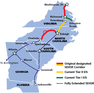
The North Carolina Department of Transportation (NCDOT) and the Virginia Department of Rail and Public Transportation (DRPT) have released a report recommending to the Federal Railroad Administration (FRA) the preferred rail alternative for each of the 26 sections of the Southeast High Speed Rail (SEHSR) corridor between Richmond, Va. and Raleigh, N.C. (R2R).

The report alternatives are based on considerations concerning the human and natural environment, costs, and operability/constructability. Also considered were the public, local government, and agency comments received following the May 2010 publication of the SEHSR Tier II Draft Environmental Impact Statement (DEIS) for the R2R portion of the SEHSR. Eight public hearings were held in July 2010 to provide information on the alternatives and obtain public input, and several alternatives have been redesigned based on comments received from the public.

Once approved by FRA, the preferred alternatives will be presented in the forthcoming Tier II Final Environmental Impact Statement (FEIS), anticipated to be published in early 2013, followed by a Record of Decision from the FRA and a second round of public hearings.

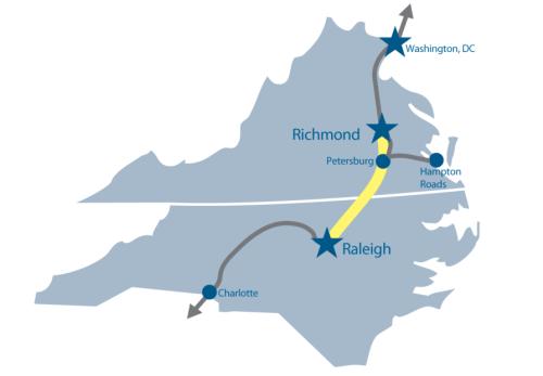
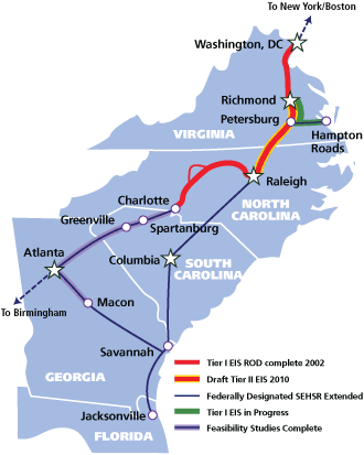
The SEHSR project proposes to implement approximately 162 miles of high speed rail as part of an overall plan to extend high speed passenger rail service from the Northeast Corridor (Boston, Mass. to Washington, D.C.) southward through Virginia to Charlotte, N.C. and Florida.

The Recommendation Report is available for download on the project website www.sehsr.org.

A lengthy process but another milestone achieved in this plan to better connect North Carolina’s cities to Richmond and points north. For more posts about the Southeast High-Speed Rail project and how it relates to downtown Raleigh, dive into the archives tagged SEHSR.

Looking at the draft recommendation report, there are sections that go over the public hearings that took place starting in 2010 as well as an overview of the comments received. I pulled two of the charts from the report and have them below.

SEHSR public comment project support overview

SEHSR public comment importance of project elements
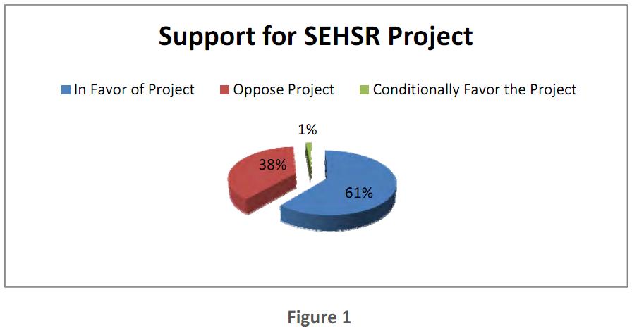
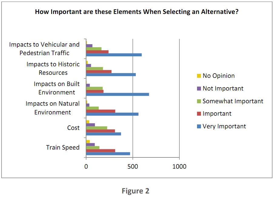
Click on the graphics for a larger view.

There are a couple of interesting points in the second figure. The exact numbers aren’t provided so based on the graph we have:

  • The two most important issues to respondents, that is combining the “Important” and “Very Important” response, were Impacts on Built Environment and Impacts on Natural Environment.
  • Cost appears to be the least most important element, getting the most “Not Important” responses.

Without deeper surveys, the results can be interpreted in different ways so take it for what it’s worth.

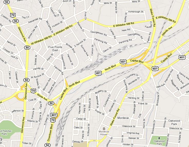
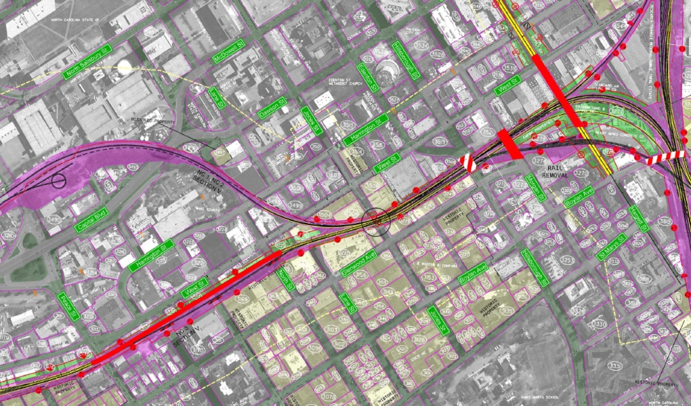
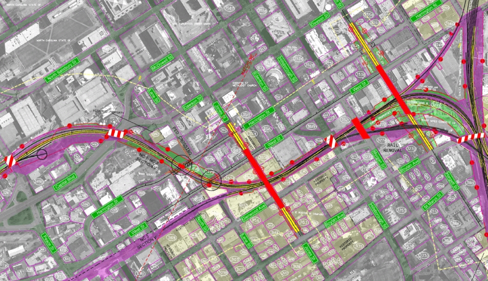
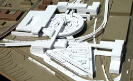
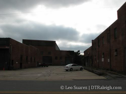
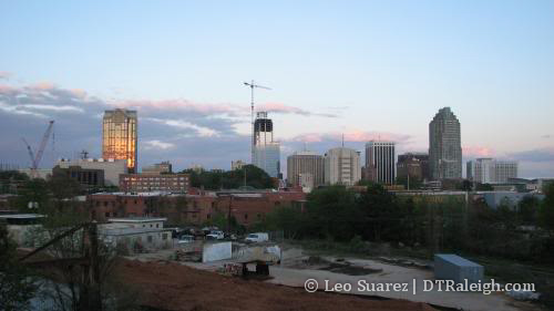
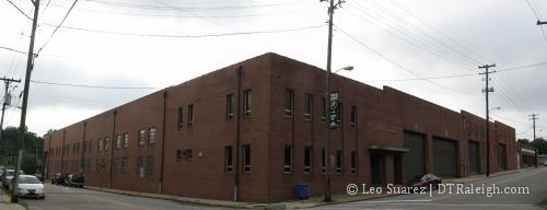
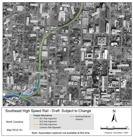
Continuing through, the document then explores each of the twenty-six sections of the route with an overview of alternatives and the final pick of the preferred route for this section. The North Raleigh to Downtown Raleigh piece is the last section mentioned, section V.

The report recommends the NC5 Alternative. We’ve analyzed the NC5 plan back in September 2011 when it was announced. From the document:

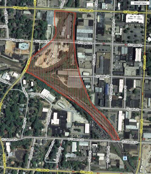
The recommended preferred alternative in Section V is Alternative NC5.  This decision is based on the fact that it minimizes impacts to neighborhoods, freight operations, and historic resources, and was endorsed by the Raleigh City Council on October 4, 2011.  Exhibit 56 shows that NC5 has the least impacts to streams, no residential relocations, fewer business relocations compared to NC3 (but greater than NC1 and NC2), and only one severely impacted noise receptor (compared to 40 for the other alternatives). Additionally, apart from the impact to the historic Raleigh and Gaston Railroad Corridor that is common among all alternatives, Alternative NC5 has no additional impacts to historic resources.  Each of the other alternatives (NC1, NC2, and NC3) would have an adverse effect on at least one resource protected under Section 106 of the NHPA, and also require a Section 4(f) use of those properties.

NC5 is also favored by the public. Following the Project Update Meeting, 61 comments were submitted by the public expressing preference for an alternative: three were in favor of NC1 (with no specific reason stated); three were in favor of NC2 (based partially upon cost considerations); three were in favor of NC3 (based upon rail designs, interaction with freight railroads, and downtown connectivity); while 52 expressed a preference for NC5 (based primarily upon minimized impacts to neighborhoods, freight operations, and historic resources).

To see the figures and maps, as well as information on each section, download the report.

High Speed Rail Adds NC5 Alternative, More Massive Maps No Monitor Can Handle

High speed rail talk is back! It has been just over a year since the last major update on the plans to run high speed rail from Raleigh to Richmond, Va. This time, a new alternative has been released, called the NC5 alternative, and SEHSR.org has a massive map that you can download to see this proposal.

First, let me plug the meeting about this update.

The public is invited to attend a Project Update Meeting to learn about a new rail alternative developed for the SEHSR [Southeast High Speed Rail] corridor in downtown Raleigh, NC. The meeting will be held Tuesday, Sept. 27, 2011, from 4 to 7 p.m. at the Raleigh Convention Center.

For some history on the project, you can dive into the older RalCon posts here. The short of the story is that in the summer of 2010, three plans were on the table for the portion of the rail line running from Whitaker Mill Road to the future station in Downtown Raleigh’s Boylan Wye. Comments from all three plans were taken in and now a fourth alternative is on the table. By the way for the mathematically gifted, an NC4 alternative was a real idea last year but didn’t gain much ground, hence the NC5 naming of this recent one.

The SEHSR site introduces this new alternative nicely:

Alternative NC5 was developed in response to strong public opposition to Alternative NC3, as well as to the City of Raleigh’s opposition to the disruption of traffic and pedestrian patterns in the area around Jones Street and Glenwood South presented by Alternatives NC1 and NC2. It was also developed to minimize impacts to the freight operations within the Norfolk Southern and CSX rail yards. Last, Alternative NC5 was developed to avoid impacts to historic resources listed in or eligible for the National Register of Historic Places. Along with the development of Alternative NC5, revisions have been made to Alternatives NC1, NC2, and NC3 based on comments on the DEIS. All alternatives have removed the bridge on Hargett Street over the railroad, and would instead close the Hargett Street railroad crossing. In addition, a pedestrian bridge along Jones Street over the railroad corridor was added to Alternative NC3 (as well as the new Alternative NC5) to mitigate the effects of the road closure.

If you want, you can download the pdf in its original form at this link, taken right off the SEHSR site.

However, if you happen to like maps that have north pointing straight up, like I do, I have cut, copied and rotated the same version with north pointing towards the top of your monitor. For smaller viewing, I’ve also included key sections of the map that show the major changes.

Rotated NC5 map full map (3605×4274)
Whitaker Mill elevated bridge (600×500)
Wade Avenue and bridge over Capital and West (600×500)
Jones Street pedestrian bridge (600×500)

UPDATE: 09-18-11

Steven Waters has made a mash up of the NC5 alternative and Google Maps. See the overlay at this link.

Walking Riding through NC5

Let me attempt to talk you through this route. Place yourself on Whitaker Mill road where it crosses the tracks between Wake Forest Road and Atlantic Avenue. This fictional train I’m putting you on is facing south and will be heading into downtown Raleigh.

The first change is that Whitaker Mill Road will go over the tracks. Not such a shocking change as all the alternatives propose this. It’s a requirement that high speed rail operate on dedicated tracks and not share with street traffic.

Next, starts the controversy that we went through last year. As the tracks move south to Capital Boulevard, there is a crossing between tracks owned by CSX and others owned by Norfolk-Southern. Should the high speed trains follow the CSX corridor or the Norfolk-Southern?

Under NC5, the high speed train continues south and will stay on the CSX train corridor, which are the set of tracks east of Capital Boulevard. This avoids the Norfolk-Southern railyard on the west side of Capital, something that they greatly opposed.

As the train moves southward, the next interesting piece comes around the Wade Avenue flyover. A bridge will be built over Capital and West Street allowing the trains to come out of the CSX corridor and then enter the Norfolk-Southern corridor on the west side of Capital.

The train then continues on into downtown to the future Union Station.

Now I mentioned earlier that streets must be closed for high speed rail and in Glenwood South, Jones Street is the only street where the train crosses at the same level of the tracks so by this rule, Jones would have to be closed at this point. That is the case here. Under NC5, Jones Street will be closed to vehicular traffic. However, the alternative includes a pedestrian bridge over the tracks where the other alternatives did not include that before.

A very interesting plan for sure. The pedestrian bridge over the tracks on Jones Street is a huge plus for downtown and I’m glad the idea of the elevated bridge for vehicles was essentially thrown out. With an ongoing Capital Boulevard corridor study going on, I wonder if this bridge over it will mesh well with a new corridor vision.

Enjoy the maps and provide your comments before October 27th.

High Speed Rail Noise versus Freight Noise

I watched some of the city council meeting last night and train noise was a pretty hot issue, one of the bullets the Five Points residents were firing off as to why they were against the NC3 option. What I hope, very much hope, is that the good citizens in the Glenwood-Brooklyn neighborhood and the Five Points neighborhood are against the noise coming from a high-speed train and do not think it sounds the same as a freight train.

If you are not caught up on the high-speed rail corridor debate, hit the archives tagged SEHSR here.

I support the NC3 option, with the added removal of the Hargett Street bridge, and want to wait for more details about this new NC4 option before I even touch it. I think some more investigation with this noise issue is needed because Norfolk-Southern, who is against the NC3 option, has definitely helped organize the citizens in the previously mentioned neighborhoods against new trains going through here at all. They are obviously concerned about their interested, very little or not at all concerned about ours.

A comparison has to be made here; freight versus passenger trains. In my opinion, these higher capable speed trains WILL sound different then the freight trains that go through there. This comes from my experience riding and being around trains in Asia. The passenger trains are built better probably because people will be on board and not cargo. You don’t get the clatter and clacking noise from freight trains. Hopefully NCDOT can provide better data on noise because I thought they did a very poor job answering the council’s questions about train noise last night.

Here are some random videos that are relevant to this topic. You can make up your own mind.

Freight versus High Speed rail Noise Impact on the Frankfurt-Cologne line.

Diesel cross-country train going through Shawford Station

A very quiet electric locomotive leaving a station.

High Speed Rail Meeting Tonight


Tonight is the public hearing for the Southeast High Speed Rail (SEHSR) Tier II environmental study. In short, this study breaks up the rail path from downtown Raleigh to Richmond, Virginia into subsections. Most subsections have a few alternate plans and tonight’s event is an opportunity for you to comment on them. The event starts at 5:00pm and anyone will be able to leave feedback or ask questions about any part of the rail line. At 7:00pm, several people will speak about the project and present material to the attendants. Here’s the event info:

SEHSR Tier II DEIS public hearing
5:00 – 7:00 p.m. followed by public hearings at 7:00 p.m.
Raleigh Convention Center – 500 South Salisbury Street

Read more about the event at SEHSR.org

We have already discussed the planned options on the table relating to downtown Raleigh so in preparation for tonight’s hearing, here are two thoughts to add.

Elevated Jones Street

The closing, or “retirement” in NCDOT’s words, of Jones Street at the rail crossing should be the hot topic between downtowners. One option, the CSX corridor option, proposes elevating the street over the tracks. This means that from Boylan to about Harrington, Jones would be raised off the ground. To help paint that picture, imagine the top of the street being as high as the roof of the building 518 West is in. That would mean that the next time Google Street view updates its images, this view would be a good 20 to 25 feet higher.

Let it sink in.

I’ve read the reports and walked the area, this option just does not seem to click with me. Whoever drew up this idea must not live or work in downtown. They had to of visited in a car, surveyed the area in a car, and its possible they sleep in one every night. Even if built, someone driving on Glenwood Avenue would have to turn off Glenwood, turn at Boylan Avenue, and then turn onto Jones Street in order to cross the tracks. There won’t be an on ramp put up to get you from Glenwood to Jones Street.

So the new Jones Street would further ruin the grid-like structure we have near the south end of Glenwood South, making it a little more confusing to navigate by car, pedestrian and bike access would be limited, and the Jones/Glenwood intersection would not be aesthetically pleasing. It may also create more car traffic on Boylan Avenue, which is lined with single family homes and this may lower the desirability for people to live here.

The planners say that throwing Jones Street into the air over the tracks is to maintain connectivity of Glenwood South to the rest of downtown. The CSX plan also closes Harrington and West where the tracks cross so this would help keep the area isolated. In my opinion this is the most invasive option. I wish I had numbers for this but in my opinion, cars mostly run up and down West and Harrington while pedestrians mostly cross the tracks at Jones. The closings and the elevated street would cut off the primary users.

If you can’t go over, go under

One idea that many are not talking about is the idea of burying the train. Immediately people snap back about how expensive it is and that it will probably flood during the 200 hurricanes we get each year. Also, the politics behind getting this done are out of Raleigh’s league. We’ll get to this shortly.

Five Points residents are really interested to see what happens to the Fairview Road train crossing. If the Norfolk-Southern option is chosen, this crossing would be closed. Why hasn’t the option to run the trains under this road been explored?

Looking at a map, the train would roll into town from the north and go under Wake Forest Road, like it does today. They would then turn and head through the Norfolk-Southern rail yards before hitting Fairview Road. This is where the train could ramp underground, go under Fairview, under Wade Avenue, under Peace Street, Johnson, Tucker, North, and Jones Street. It would finally pull into Union Station by Hargett Street at a lower elevation.

Did you follow that? Here’s a map.

The benefits of this option is that there would be no disruption to the current street layout, except during construction most likely. The train would go into Union Station at a much lower elevation but so what, Union Station hasn’t been designed yet! Also when the train continues west to Cary, it has all that room by NC State to ramp up back to grade level. No street closures, no train noise, no problems.

But with all the pros comes the cons.

The cost of this idea would easily be many times more then anything currently on the table. I would be a little nervous about going with the most expensive option. However, I’m the guy that spends a little extra to buy the quality brand in order to get more in the long run.

One could make the argument that running the train underground and not disrupting the growing entertainment and residential district would pay off in the long run. Union Station may spur lots of development in Glenwood South, maybe much more if streets are not closed and Jones Street is not elevated. Development on existing infrastructure is also great. That’s more tax dollars for the city brought in by visitors on the train.

If obstacles are placed in Glenwood South, the hassle may hurt. A less walkable district could lower the amount of condos being built in the future. A less accessible entertainment district may result in less conventions being booked. A confusing street grid may bring less visitors from around the Triangle, who arrive by car, and these mobile visitors can easily go elsewhere with their thirst, hunger, and money.

The politics behind modifying the Norfolk-Southern lines here, I’m guessing, would be a huge undertaking and those in the know are probably laughing while reading this. It is definitely not in Norfolk-Southern’s interest, just running it in their corridor has them upset, as was the intent of a meeting near Five Points this past Saturday.

Does Raleigh have what it takes to get the high-speed train to run the way it wants or will we approve whatever option has the least resistance?

And why is this “non-disruptive”, as far as I know, option not even on the table? Yes, I know it would be expensive but to not even present it to us, the citizens, is bad a service to us, the ones that walk the streets around here.

Alright, almost done

It’s obvious I have given this a lot of thought and I think it is a much bigger deal then people think. I’m behind all the support for a beefed up train network in this country and would love to see Raleigh as the gateway to the south with the new high-speed rail line.

These transit events, if like others, are great for getting questions answered and just having conversations with the experts about what the plans are and what ideas have been thrown around. I encourage everyone to weigh in with their opinions, not here on the blog but on the SEHSR website. Here is a link to their survey where you can tell them what you think.

Public Comments For High-Speed Rail


We’re crawling along slowly on this high-speed rail thing. The Tier II Draft Environmental Impact Statement (DEIS) of the Southeast Hish Speed Rail Corridor is now available for public comment. This particular statement focuses on the section of rail lines that will run from Raleigh to Richmond, Virginia. From SEHSR.org:

This Tier II DEIS evaluates detailed study alternatives within this preferred corridor between Richmond and Raleigh In the Tier II DEIS, the project corridor is divided into 26 sections. There are three alternatives in each section, and each rail alternative includes an associated set of highway improvements.

The point of this public comment period is for everyone living in the affected counties to look at the proposed rail paths and provide feedback to the planners. There are open events along the route throughout July. Most RalCon readers will probably be concerned with the Wake County event, which is on Monday July 26th, from 5-7pm. As always, the SEHSR website is always up and open for comments from now until August 30th. Maps are available for each section from here to Richmond with the proposed plans for the rail line.

The route in Raleigh starts at the Boylan Wye in the warehouse district. The maps showing this are available on the SEHSR site here. There are two proposals that show very different paths for trains heading north out of the wye and I’d like to focus on those in this post.

There’s good additional reading from Bruce Siceloff, who sums it up nicely with this piece in the N&O. Siceloff writes:

Should the trains follow Norfolk Southern tracks north from Jones Street along the west side of Capital Boulevard to Wake Forest Road? Or should they go along Capital’s east side, using CSX tracks?

Norfolk Southern tracks


See the full map in pdf format here.

Simply put, this option would run the trains behind The Hue condo building and along the elevated tracks that go over North, Tucker, Johnson, and Peace Streets in the Glenwood South area. The train would head north along the west side of Capital Blvd and out of town.

A major drawback to this plan would be the result of having Jones street closed to traffic. Yes, completely closed and a dead end would await you when you pull up to Natty Greene’s. This is also the more expensive option.

CSX Tracks


See the full map in pdf format here.

This option bends the train a little and makes it head north on the east side of Capital Blvd. To get over to the other side, the train would cross Jones Street, just like the previous proposal, cross West and Harrington Streets where it would then cruise over the already built bridge over Capital and then take off north out of the city.

This plan would result in the closing of West and Harrington Streets where the tracks cross. Jones Street would also be elevated to cross over the tracks.

My Initial Thoughts

According to Siceloff’s article, the city opposes the CSX option, which makes me happy. From his article:

The CSX route proposal would require a new bridge to elevate Jones at least 25 feet over the tracks – and over Glenwood and West streets nearby.

I had to read that one three times before it sank in. A bridge spanning almost an entire city block is not what I support for Glenwood South. Metal and concrete rising 25 feet in the air will destroy the beautiful character that the old electric company building brings to that section of Jones Street. It would also wipe out any pedestrian activity here and would be a huge blow to the massive amount of nightlife that takes place.

The Norfolk Southern route is what I will support but with a few comments about the closing of Jones Street completely. Obviously, I don’t want a bridge for cars to cross but zero access across Jones Street is not acceptable either. What the city could explore is the idea of an attractive pedestrian bridge over the railroad tracks. The dead end sections of Jones Street on either side are not needed also and a beautification study can be taken on. Two plazas on either sides of the tracks would be a really unique thing for downtown and would only encourage more pedestrian activity in the area.

Those are just my thoughts but make sure to get yours in on the SEHSR’s website or at the open house on July 26th.

What Should The Multi-modal Transportation Center Be Like?

Mentioned earlier in The State of The Warehouse District post, there is an opportunity now for anyone to submit their ideas about the Multi-modal Transportation Center (MTC) by July 24th. I think this is a big topic that is not talked about enough so in an attempt to get the conversation going, here are some ideas for what should come to this area of downtown over the next decade.

Background Info

The highlighted area in the map below is the core target where the MTC will go.

I’m not sure if Amtrak is in on this but they should so I included the station in my red area. Amtrak and Norfolk Southern trains are, I believe, the only real activity that comes through here currently. In the near future, we may have regional rail that goes north toward Wake Forest and West toward Cary and the rest of the triangle. There may also be a high-speed rail line that continues north toward Richmond and west toward Charlotte.

Build a Transit Center

With lines coming in from around the area and out of state, the MTC should be the hub of travel outside of RDU. Passengers that arrive should have the option to get a taxi, transfer to another train or bus, rent a bike, get picked up by a friend, or walk off in a pedestrian friendly environment. I’m still debating whether a car rental service would be needed but this can be avoided with good planning; some people still need to drive to get to where they are going.

Warehouse Renovation

Rather then build the entire MTC from scratch, we can always use what we have. The warehouses along the railroad tracks offer a perfect opportunity to bridge the old with the new. Heavy renovation could turn this into a shopping center for travelers arriving or departing the area. We’ve heard of plans for residential infill within the warehouse district so that will only fuel the activity even more.

The MTC Does Not Need To Be Tall

This area is a little tricky because of the transition between residential neighborhoods and downtown. Would a 10 or 20 story building fit in here? Would you protest if a truly iconic skyscraper was on the table and would block your view from the Boylan Brewpub patio? I may change my mind later when the proposals come in but for now I think that a tall development would be out of place. Low rise office and condos that blend well with the warehouses and Boylan Heights is key. The area is about transit and focus on the pedestrian should be point number one.

Plan For The Future

The population figures I keep reading say that Wake County will have another million people over the next 25-30 years. The MTC should be built for this population boom as well as expandable for even more traffic. I think space for an extra track or two should be saved, another site saved for a potential downtown rail circulator, and would it even be way out there to plan the MTC so that a subway could be built underneath? We are definitely years from that but considering it and engineering the building around these may be worth a small cost now rather then a huge redevelopment later in the future.

…..ooh and we also need an awesome name for it.

The State of the Warehouse District

By day, the warehouse district of Downtown Raleigh is quiet and sleepy. By night, it wakes up and comes to life, exploding on the weekends. This nightlife hotspot has seen some problems in the past, but with a convention center only a few steps away, why can’t it enjoy some traffic just as Fayetteville St. will be getting? Here is some recent updates if you have not been down there recently.

  • Penrod’s Antique Warehouse has opened up next to White Collar Crime and makes use of the entire 10,000 sq. ft. warehouse. They have very old furniture and all kinds of random plates, paintings, silverware, etc. They are open seven days a week.

  • Jibarra is re-locating to The Depot but work there has not yet started. The place is still filled with the old bars from the trio of clubs that left back in November of 2007. Jibarra seems confident on opening up this fall.
  • Renovation of a warehouse for the Contemporary Art Museum seems to be continuing. A recent ‘Pic of the Week’ entry had some good discussion from readers.
  • Discussion on the Multi Modal Transit Center is picking up and the city wants your ideas. Read their ‘Call For Ideas’ on the Transit Center and submit them by July 24th. I have not read the entire document yet but may post my thoughts later this week.

The warehouse district will need more shops and the museum to open for activity to rise during the day. The transportation center, I think, will define the warehouse district in the near future and when (if) built, this area will explode during the day.


Plenty of parking at The Depot

Study Continues On High Speed Rail In Raleigh and NC

Discussion about a high speed rail line from Washington DC, through Raleigh, to Charlotte has been mentioned before and we now have an update in the study process. With regards to Raleigh, David Foster, a project manager on the project, states:

The environmental work is substantially complete between the VA-NC line and Raleigh. The initial railroad horizontal and vertical alignment alternatives also are complete along this section. Roadway designs are essentially complete from the VA-NC line through Franklin County, and are in progress through Wake County. The Franklin/Wake County sections are some of the most complex due to heavy development.

Section 106 consultation with the State Historic Preservation Offices in both Virginia and North Carolina is still required. Efforts to obtain the necessary effects determinations for the individual historic resources in each state will begin as the design work is finalized.

The website for the project has a plethora of information, including the entire planned corridor shown with aerial pictures.

http://www.sehsr.org/

Looking at the downtown section we can see what is planned. Before looking, it is pretty easy to guess that the plans are to use the existing rail corridor that runs along capital BLVD into downtown. This makes most sense because of the planned multimodal transit center to be built in the warehouse district. The project timeline was updated last month with an estimate to have passenger service running some time between 2015 and 2020. This is all “dependent upon funding availability” but the gears are rolling and Raleigh may be a major hub for the east coast high speed rail line in the coming decade.