Suds and Speculation posts are ideas I came up with usually while drinking and socializing with friends or people I meet. It is usually paired with real data leading to some idea, or dream, that we can speculate on for downtown Raleigh.
I attended this month’s Downtown Living Advocates meeting and trains were a hot topic. The timing was nice cause it came after the city’s passenger rail task force (PRTF) made their recommendation to the Raleigh City Council on which light rail alternative they prefer for the downtown Raleigh section. To watch the presentation, jump back to this Municipography post on July 6th, 2011.
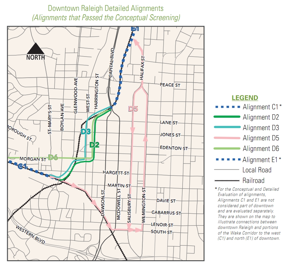
To continue my intro on this, take another step back to March 2011 where many alternatives for the downtown Raleigh light rail route were on the table. At this point, planners and citizens could weigh in on each plan. Around that time, there were four alternatives that were being seriously considered and have moved on to the next round. Those four alternatives, D2, D3, D5 and D6, are shown on this map. (click for larger)
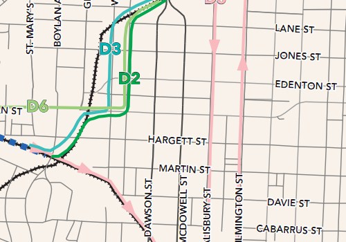
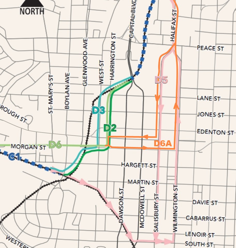
It has been a couple of months now and decision time is coming up. The city, Triangle Transit and the PRTF all have opinions on this and the city council will narrow things down to a final winner with their approval. So far, of the four plans that moved forward earlier this year, we seem to have support behind just two plans. The alternative called “D6” looks tempting because it involves no elevated flyovers, a stop for the government district a short walk away and is projected to be the cheapest alternative. The second alternative with some backing is the PRTF recommended “D6A”, called that because it is a hybrid of two routes. Let’s add D6A to the map of alternatives.

If you can’t already tell, D6A was not on the list and now makes it five possible alternatives to choose from at this point. After some initial study, if deemed feasible then D6A gets a chance in the ring and we’ll go through a process of analyzing it against the other recommended alternatives.
Now here’s where you come in. There will be a public workshop and lecture about this plan and the others. Don’t comment on this blog post about your thoughts until after you have sent them in to the city for or against D6A. You can attend this lecture to hear more about the plan and drop some comments about it. Details are:
Monday August 1st, 2011
5:30pm – Workshop
7:00pm – Public hearing
Council chamber, Upchurch Government Complex
222 W. Hargett St.
Now that the info is in front of you and I’ve passed along the details for the meeting, we can move on to some thoughts and discussion. It’s D6 versus D6A at this point. The D5, D2 and D3 alternatives are more expensive than D6, most likely because of the flyovers that need to be built. I also want to remind readers that the vehicles of choice here are three vehicle, 90 foot train cars for a 270 foot long train set. A typical city block is about 400 feet so the trains would take up half the length when rolling on downtown streets. Here’s a map of just the two alternatives for a more direct comparison.
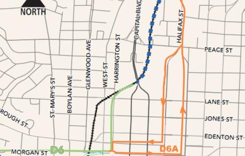
I added the D6A route line on those maps so please feel free to send me a pat on the back for my talent with Paint.NET. Kidding, it’s horrible but hopefully it helps.
Light Rail in Raleigh, think of the big picture
To pick which route you like best, I think one has to start by looking at the whole system and the people on it. If you zoom out and look at this light rail line going from Cary through downtown and up to North Raleigh, you’ll see that the proposed stops are miles apart. This is how a light rail system works, moving people from one area of town to another. Larger than a light rail line, a high-speed train moves people between cities and going smaller, streetcars drop people off as often as every 400 feet. Now the tricky part of the downtown Raleigh light rail section is that it will cruise down the streets like a streetcar. Does this mean that it should behave like a streetcar when in downtown?
If your answer is yes, then I think D6A is your route of choice. This route offers more opportunities for bunched up stops and pedestrians can jump on and off more freely. The route penetrates downtown more than the D6 alternative, bringing a rider to the head of Fayetteville Street at the Capitol and right alongside the state government district. The rider catchment area is also greater, giving east Raleigh easier access to light rail.
On the flip side, if you believe that the light rail should drop people off in downtown and continue on it’s merry way down the streets then the D6 alternative is for you. Union Station should be a grand entrance to downtown and therefore riders can transfer to other modes of transit to get to where they are going. Looking at the big picture of the Raleigh light rail, this alternative also gets people in and out of downtown faster.
So each has its strengths but not without some weaknesses.
The weakness of D6, from my perspective, is that it doesn’t bring people into the core of downtown Raleigh. Riders from Cary and North Raleigh don’t have access to the middle of town and have a little more of an obstacle or another transfer to get to their final destination.
I’m not letting D6A off the hook though. The D6A route makes a 270 foot train act like a streetcar in a city grid where 30 foot streetcars roamed nicely over a hundred years ago. The streets haven’t changed much so fitting this behemoth onto downtown streets could be a bit tight. For reference, the modern streetcars in the city of Portland are 66 feet long, their MAX cars are 92 feet long and only operate as single vehicles.
So which one should Raleigh build?
In my opinion, the D6 route serves the entire city best if it makes a stop or two in downtown and does not try to act like a streetcar. The light rail is part of a multimodal transit network, one that has to compliment the other modes of travel. Downtown streets are best served by true streetcars, a network that should come much later in Raleigh’s transit planning future. To force the light rail line to act like one is risky and may not set a good foundation for future transit growth.
Building a Multimodal Network
So this is where I start to pitch my support for D6 over D6A. I had to think about it for awhile but I’m pretty set at this point.
I think those that are looking for that streetcar experience in D6A are losing sight of what a full transit network should be for Raleigh. The light rail line alone is not the answer to getting people to using transit. Along with the light rail, we’ll have upgraded bus routes, circulators and better accommodations for cyclists and pedestrians to get to and from transit stops and final destinations.
Transit, by nature, is multimodal so that is how everyone must think when imagining using a transit network that doesn’t exist yet. Riding will always involve, for 99.9% of people, a walk or bike ride to the nearest bus or rail stop, travel to another stop, then get off and ride or walk to their final destination. There may be one or two transfers, or connections as it’s called outside of this country, to ultimately get you to where you are going.
I feel D6 sets this possible network up in the future. Imagine a spiderweb of streetcar lines coming off the D6 line to move people around downtown and the surrounding neighborhoods. That would be possible, and the natural next step for Raleigh, if the light rail is successful in helping spur development around her stations.
How does D6A set up this future multimodal network when it tries to do it partly on its own? Think of the new obstacles in creating connections around a light rail line that has multiple stops in a congested downtown with narrow streets. You don’t get that natural ease of mode change with D6A and we may be setting ourselves up for future lines to run on top of each other, which isn’t an efficient way to run a transit network.
If you look at the 2030 Comprehensive Plan, the light rail line is for moving people between the planned growth nodes and to spur transit oriented development in those areas. I feel the best use of the light rail line is to move people between these nodes according to the plan, not within the nodes as D6A tries to do in the downtown piece.
One More That May Seal It For You
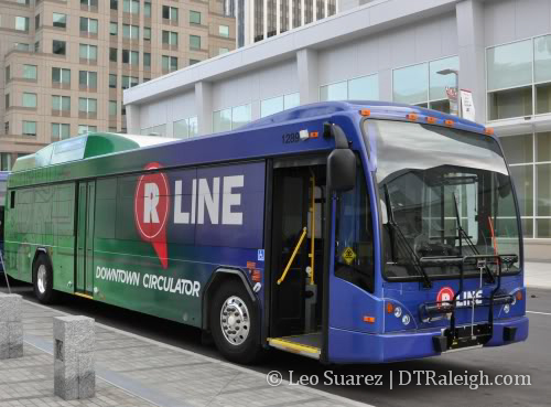
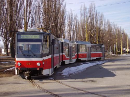
This one kind of hit me when I was riding the bus home and stared out at the NC State Capitol as we drove past it. Aesthetics are very important to some so let me remind you that the light rail cars will be electrified with overhead catenary wires, like the first picture in this post. D6A wants to run the trains right down Hillsborough Street from Salisbury to Harrington Street, a street with a nice view of the Capitol building. Now it’s no Fayetteville Street but long time readers or anyone following downtown may remember the Plensa fiasco of 2006. For a recap, jump to:
Collision of complex forces defeated plaza via newsobserver.com
Back then there were great concerns with the design of the plaza and how it would block the view down Fayetteville Street. If I recall correctly, the city even paid $10,000 to set up a mock up of the design so that they could see how it looked first. We ultimately couldn’t make a decision on it, making the process take so long that the $2.5 million gift was retracted and the project eventually died.
Anyway, that is in the past and may not be an issue this time but I swear people get really upset about overhead wires so maybe this is important to you.