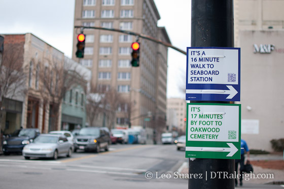
The Walk Raleigh project is brought to you by the good folks at CityFabric. Their latest tweet is interesting, with an equivalent Facebook post mentioning more permanent signs.
https://twitter.com/#!/WalkRaleigh/status/161561048002990080
The Walk Raleigh project is brought to you by the good folks at CityFabric. Their latest tweet is interesting, with an equivalent Facebook post mentioning more permanent signs.
https://twitter.com/#!/WalkRaleigh/status/161561048002990080
Hotel space seems to be a lacking resource for downtown Raleigh but reading through the city’s Budget and Economic Development (BED) Committee agenda yesterday shows more rooms may be on the horizon. Longtime readers will remember The Lafayette project proposed for what is called “Site 4”, the parcel of land along Salisbury Street that butts up against the Performing Arts Deck. That project is officially out the door and the city is ready for new blood to come into town.
Looking through the agenda, City Manager Russell Allen sent a letter to the BED committee to suggest they consider Request For Proposals (RFP) of the site. He mentions multiple requests have come in from interested parties. He includes a copy of one such letter of interest, copied again by me and pasted below:
October 27, 2011
Mr. J Russell Allen
City Manager
City of Raleigh
P.O. Box 590
Raleigh, NC 27602Dear Mr Allen:
Summit Hospitality Group, Ltd. would like to engage with the City of Raleigh in the appropriate process to acquire the three parcels of city property on South Salisbury Street at its intersection with Lenoir and South Streets. I believe this is generally referred to by the city as their “Site 4”.
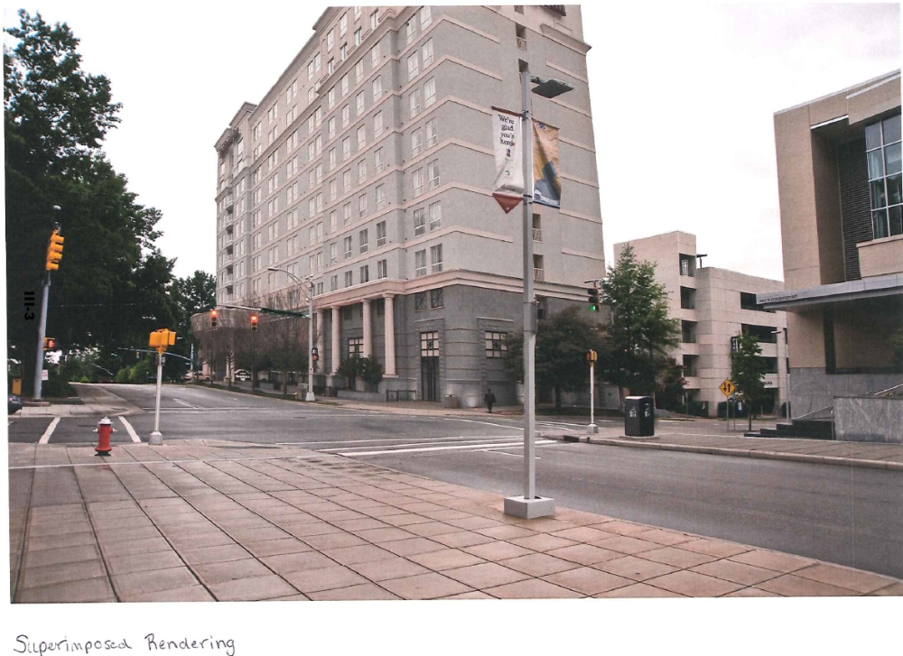
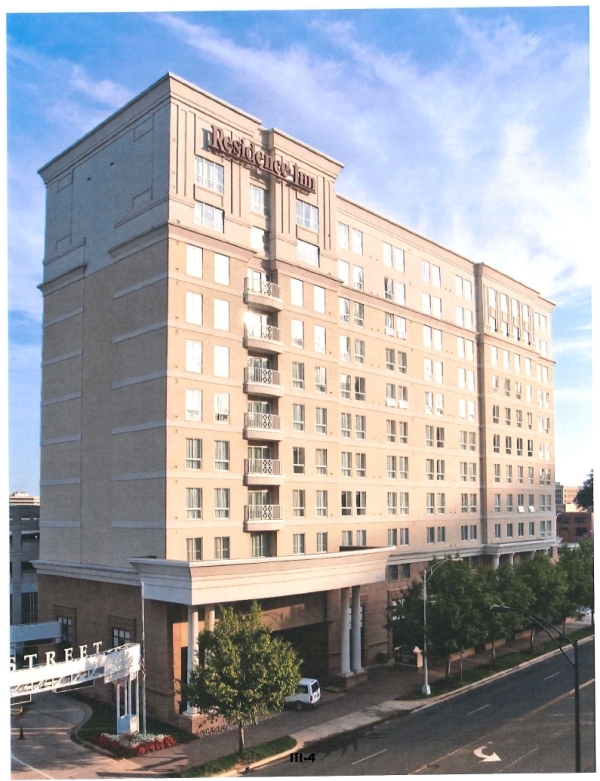
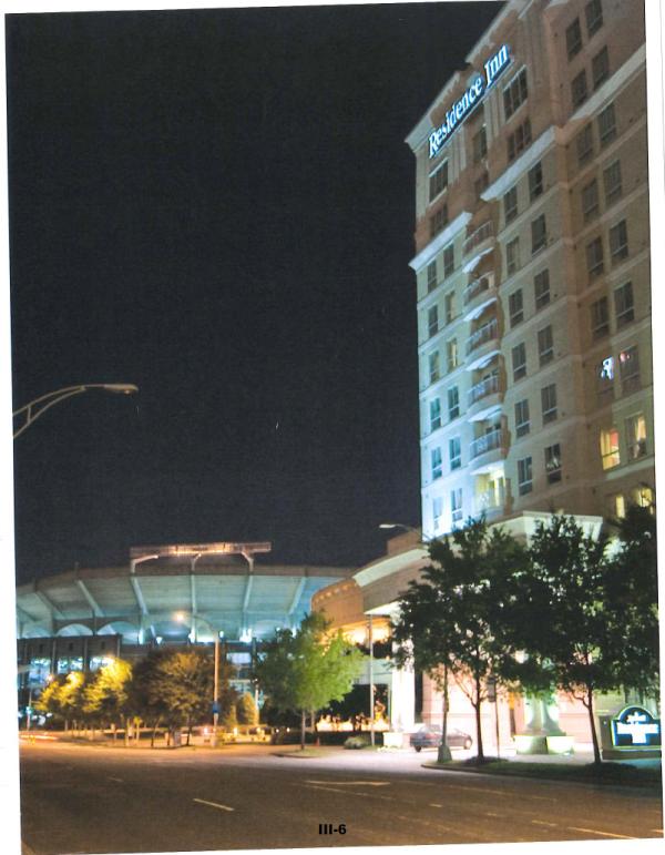
The intent for the property would be the development of an upscale mixed use property, the largest tenant being a MArriott extended stay hotel. The hotel would be similar in scope and scale to a similar property located on Mint Street in Charlotte, NC. For purposes of illustration, I have enclosed photos simulating the hotel situation on the Raleigh site as well as photos of the Charlotte hotel.
We have a verbal approval for a Residence Inn by Marriott franchise and tentative financing from local conventional sources contingent on the strength of a market study by a nationally recognized form. As soon as we could enter into a Letter of Intent or Memorandum of Understanding with the city, we are poised to immediately contract for the market study and begin the design phase for the presentation to the city.
Regards,
R. Doyle Parrish
President
The attached pictures are shown in this blog post. Here’s a Google Streetview link to the hotel in Charlotte. I’ll emphasize that the pictures here are not final and no designs exist at all. This is just a model, made up for visualization.
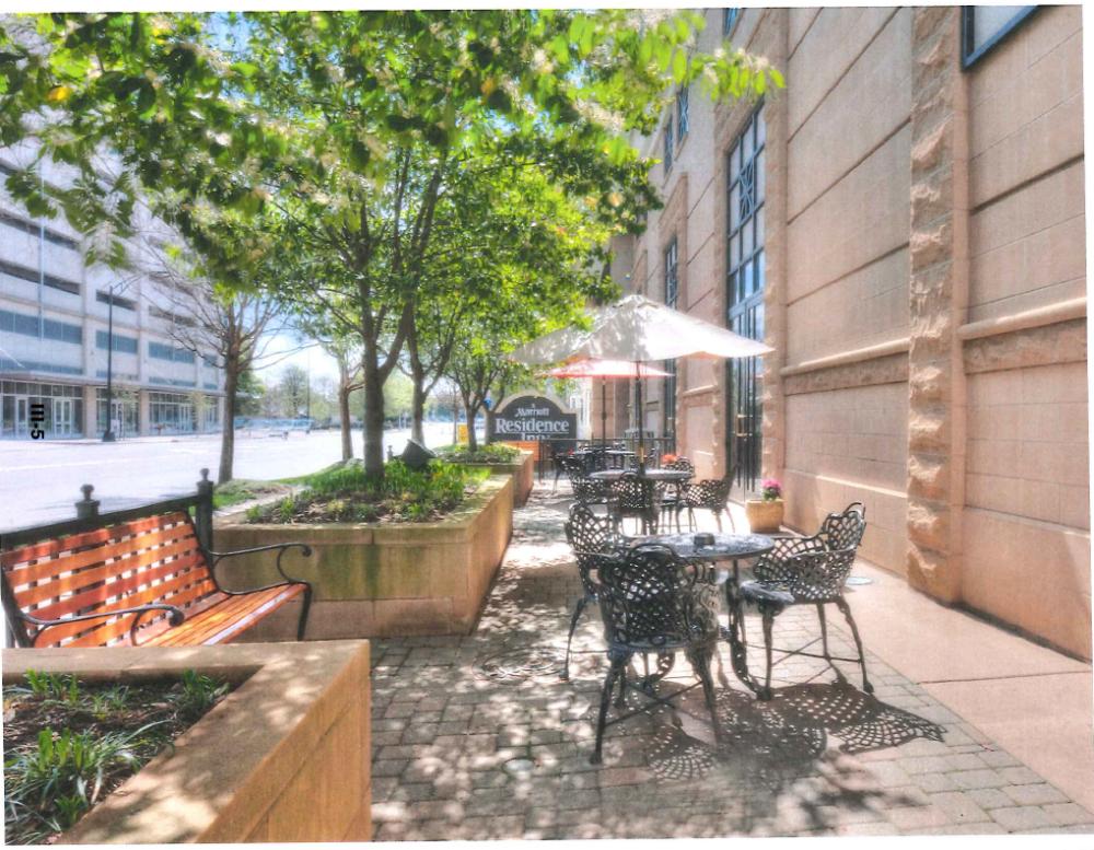
The Raleigh Convention Center needs more of this in order to host some of the much larger conventions that it can handle but are not getting because of lack of hotel rooms. Skyline fans may be disappointed as a building of this scale is nothing to cheer about.
For me, it’s a great project really. The building should make a great compliment to the Performing Arts deck, helping make use of the extreme oversupply of parking that we have in downtown Raleigh. Also, while not unique in character, the urban form is a fine addition to the sidewalks of Salisbury Street. If you take our Marriott hotel on Fayetteville Street for example, the street trees, tables, and chairs are inviting. I see people sitting and relaxing there on many occasions.
The location of this hotel is also primo. It’s easy to get in and out of downtown by car and visitors can experience the Fayetteville Street/City Plaza area with much ease.
We’ll stay tuned for updates.

We’re about two weeks into the year now and if you’ve fallen of the “lose weight” resolution train, eats in downtown Raleigh won’t judge. Last fall, we ran through a few new openings. For winter, work continues on some establishments but there are still a few new places for you to explore.
Tyler’s Taproom is probably the biggest recent opening with their Seaboard Station location finally serving brews and food. It was first mentioned on this blog back in June, 2008 so the opening is very much welcomed by Tyler’s fans. If you’ve been to the other locations around the Triangle, you know what to expect here. The large space and outdoor patio should be popular with families and larger parties.
Other downtown Raleigh restaurant happenings:
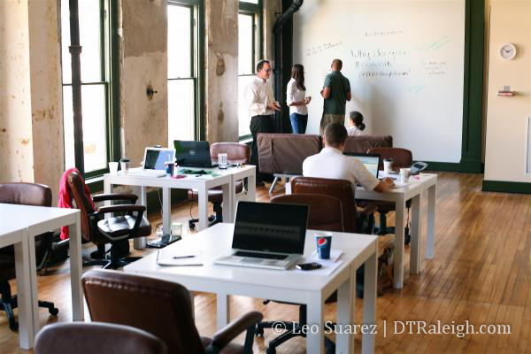
Photo credit: Tyler Helikson
Coworking is a concept that I’ve mentioned before on the blog and downtown Raleigh’s coworking space, The Raleigh Forum, brings it right onto Wilmington Street. With Red Hat moving its world headquarters to Davie Street, coworking is important for the small startup community and open source environment that the grand fedora feeds off of.
From my inbox to your screen, here’s an upcoming event that will allow you to see the coworking setup and mingle with the community.
A Night in Raleighwood
The Raleigh Forum and iContact to host an Academy Award-themed party
WHAT: The Raleigh Forum- a downtown coworking space- and iContact- will host an Oscars-themed cocktail attire party on January 26. Attendees are invited to walk the red carpet, pose in front of the step-and-repeat, vote for the winner of awards categories, and bump elbows with locals during this music-infused awards party.
Beer and wine will be provided at the open bar by The Wine Feed. Appetizers are provided by Gravy, courtesy of Empire Eats. Local singer-songwriter Erik Smallwood will be playing acoustic music throughout the event. 50% of entrance fee proceeds will be donated to Change the Triangle, the Triangle’s young professional volunteer organization.
WHO: The event is open to the public but you must have a ticket to enter. Tickets are $15 and can be purchased theraleighforum.eventbrite.com.
WHERE: 133 1/2 S Wilmington St, Raleigh, NC 27601
WHEN: Thursday, January 26 from 7:30-10:30pm
WHY: This party will showcase The Raleigh Forum’s temporary office space, as well as honor loyal supporters of The Raleigh Forum and advocates for the Raleigh community.
CONTACT: Cristina Roman
PHONE NUMBER: 919-452-6381
EMAIL: cristina@theraleighforum.com
WEBSITE: theraleighforum.com
One of the things that get me excited just as much as new shiny towers is when downtown spaces are reused in a creative way, especially the smaller buildings. Reusing a building before demolishing and building new, especially with so many lots available, will not grow our downtown at all.
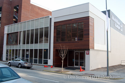
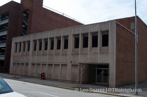
The Alfred Williams Company gets a big Cheers! for its work on their building at 410 South Salisbury Street. The completed project is shown above with the previous building state shown below. (picture taken in January 2011)
The 143-year old company started in downtown Raleigh and is now back in town with it’s 50 strong workforce. The company works on the second floor of the building with hopes to lease out the ground floor.
Another draft of the city’s Unified Development Ordinance (UDO) is now out for public comment. I’ll admit, this is a tough one for citizens to swallow so perhaps after some time, there will be some highlights about it. For now, I’ll try to inspire readers to dive into the documents over at the city’s webpage for the UDO.
If you have time, please watch this video, embedded above, from the city’s Youtube channel that talks about the new code and can maybe clear this up for more people, even if just a little.
Municipography is a summary of current issues going through the Raleigh City Council and other municipal departments in the city. The point is to try to deliver any video, photos, and text associated with the discussions happening at City Hall or elsewhere. Since this is a downtown Raleigh blog, the focus is on the center of the city.
The first Raleigh City Council meeting of 2012 was held yesterday. The proposed Union Station was discussed and the agenda describes it just as well as I can. From the January 3, 2012 agenda packet:
F. REPORT AND RECOMMENDATION OF THE PASSENGER RAIL TASK FORCE
1. NCDOT Concept for Raleigh Rail Station
At their December 12, 2011 meeting, the Passenger Rail Task Force discussed proposed improvements to the Dillon Viaduct Building by NCDOT to convert the facility to a passenger rail station. The new station would replace the existing train station on West Cabarrus Street and would accommodate existing Amtrak service, proposed future high-speed rail service, and the proposed future Triangle Transit commuter rail service. The passenger rail station would be the first phase of a larger Union Station multimodal facility that would also provide service to local bus, regional bus, and light rail services. City staff will continue to work on conceptual designs for future phases of the Union Station multimodal facility.
After reviewing draft concept plans presented by the NCDOT Rail Division, the Task Force voted unanimously to recommend endorsing the proposed Viaduct Building rail station retrofit concept. A complete copy of their evaluation is included in the agenda packet. $3 million has been appropriated for City participation in the cost of this facility
as part of the 2011 Transportation Bond and will be available in FY13 in the draft Capital Improvement Program.Recommendation: Endorse the findings of the Passenger Rail Task Force to retrofit the
Dillon Viaduct Building for use as the rail station of Union Station.
The council voted unanimously to endorse this site and the plans recommended by the Passenger Rail Task Force. Watch the video below for more discussion about it during the meeting.
A great pdf document that goes over the concept of turning the Dillon Viaduct building into a train station is “NCDOT Viaduct Building Assessment”, taken from the Passenger Rail Task Force webpage on the city’s website. You can download it here. In this document, you can see the phased approach to adding new platforms for Amtrak, commuter rail, and high-speed rail to the Boylan Wye as well as other additions to accommodate the station.
Downtown Loan Program
The Downtown Loan Program was created for properties along Fayetteville Street, typically older structures, to be brought up to proper code for owners and potential tenants. This was an effort to help bring businesses to the Fayetteville Street area after it’s renovation a few years ago. The loan program is now being expanded to more streets in downtown Raleigh. From the City of Raleigh’s press release, the streets include:
The program will include portions of Dawson Street, Glenwood Avenue, Hargett Street, Martin Street, Davie Street, Fayetteville Street, Blount Street, Person Street and designated at primary retail Street in the Comprehensive Plan. Designated secondary retail streets include portions of Harrington Street, West Street, McDowell Street, Dawson Street, Salisbury Street, Wilmington Street, West Morgan Street, Hillsborough Street and Peace Street.
And finally more about the program:
The program is designed to create an incentive to new and/or expanding Downtown businesses and commercial property owners seeking to improve properties. To be eligible for the loan program commercial property owners and business owners must demonstrate management ability and experience. Qualified applicants must show they are unable to secure financing from financial institutions for the amount being requested from this program. To date the program has made three loans to area businesses. One of the loans has been fully repaid. Currently $200,000 is available.
The expansion was approved by the council during the consent agenda.
Tubes of Light by dtraleigh, on Flickr
2011, what will we remember you by? All-star weekend or Hopscotch 2? Could the food truck saga of this year be the one that sticks out in your mind? Or perhaps, if affected, you may still be dealing with damage from the April tornadoes?
On planning downtown Raleigh, this past year has been pretty active with long range plans becoming more detailed, less alternatives, and more decisions. Missing was another Raleigh Wide Open but there were plenty of events that kept spirits high. One of the biggest feather in downtown’s hosting cap was the 2011 NHL All-Star game, bringing a new format from years past and was reviewed very positively across the hockey world.
As always let’s first start with the 2011 wishlist. This list only consists of items that can be done in one year’s time.
For a second year in a row, a bookstore has not happened. Reading articles about Amazon selling a million Kindles a week this holiday season really isn’t helping new bookstores open especially an independent store in a relatively low traffic, downtown area. Probably the best thing is for downtown residents and workers to support the Wake County express library on Fayetteville Street. The library is open Monday to Friday from 10am to 6pm so if you can work it into your schedule, give this location a shot.
I feel some businesses have tried to expand their operating hours this year. I didn’t keep track of this one very well so correct me if I’m wrong. A few examples that I can think of are The Pit opening on Sundays, Wilmoore Cafe having weekend hours, Poole’s Diner opening on Tuesday nights, and Mecca adding some hours as well. The wish really is to get to the point where downtown Raleigh is “open for business” at all times of the day and night so that people feel there are several options available to them. This pushes the 24/7 idea closer to reality.
Counter service food options are still out on the horizon. Chuck’s attempted counter service but later changed it due to requests. Perhaps more residents in the area will help expand the quick and cheap eats category options.
The downtown Farmer’s Market continued to serve up City Plaza each Wednesday this year during the warmer months, just like the last one. This is probably the closest thing to market style food buying that we’re going to get for awhile. There is however a produce shop over in City Market that a lot of people don’t know about. Walk over there and give them a try if you are into Farmer’s Markets.
There was plenty of transit talk this year and plans are taking steps forward. In light-rail news, the city picked their preferred alternative which involves a light-rail line to enter downtown from the west on Morgan Street and hang a left on to Harrington Street to exit downtown to the north. A comprehensive bus plan has also been released with plans to significantly expand bus service around Raleigh and the rest of the Triangle. High-speed rail is also moving along with a new plan to bridge the trains over Capital Boulevard into Glenwood South as they head for Union Station in the warehouse district.
Construction in 2011
New building construction moved along in 2011 with projects continuing to take shape or break ground. Here is a list of construction projects we’ve been following all year.
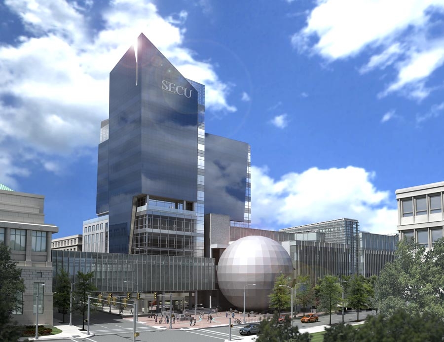
Go here for a gallery of renderings of SECU and Green Square.
Other highlights of 2011: