New Bern Avenue Corridor Study Comments and Bicycle Lanes

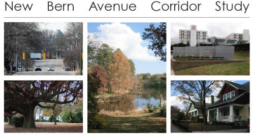
The New Bern Avenue Corridor study has been going on for over a year and the final draft report is now available. You can view it on the City of Raleigh’s study page here. The twenty-seven page pdf goes through all the issues of this corridor and lists recommended actions to take in order to improve the study area. The city is looking for comments about it so get them in before January 2. Here’s how.

  • Download the New Bern Corridor Study and send your comments to: dhanya.sandeep@raleighnc.gov
  • View the New Bern Corridor Study at the Planning Office and mail your comments to:

    City of Raleigh
    Planning & Development
    P.O. Box 590
    Raleigh, NC 27602

One piece of the corridor study that I commented on was the bicycle lanes. The study recommends a new street layout. Picture of that below.
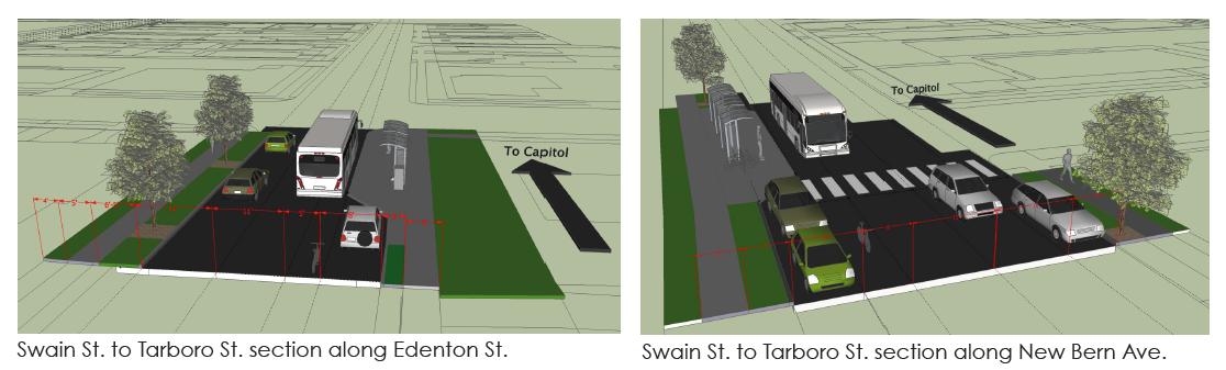

Click for larger

The one-way streets of Edenton and New Bern are laid out, going left to right, with two vehicle lanes, a five foot bicycle lane, and an eight foot vehicle parking lane. The two way section of New Bern has a similar layout on both sides with a median in the center.

This layout irked me a bit after seeing it so after some thought I did some research and commented on the plan. Here is what I sent in:

“Hello, Dhanya.

Great work on the final draft of the study. I did want to pass along some comments of mine as I read through the report, specifically about the bicycle lanes.I hope that the city can consider an upgraded plan for cycling along this corridor to be implemented either with this New Bern vision or at some later time when funding becomes available.

The plan in the report shows that a cyclist can ride in a five foot wide travel lane with parked cars to the riders’ right and moving traffic to the riders’ left. In this layout, a cyclist is at risk of injury with cars entering/exiting parking spaces as well as at risk of being “doored” by unaware drivers exiting their vehicles. Buses will also stop within the bicycle lane in order to drop off and/or pick up new riders at bus stops. Since the New Bern Corridor has the highest ridership of any Capital Area Transit (CAT) bus, the chances for this to happen is high especially in the coming years if transit grows in Raleigh.

I propose the city consider an upgraded cycling transit plan for the New Bern Avenue Corridor where bicycles can flow with equal ease as nearby buses and cars on the road and pedestrians on the sidewalk. The five foot bicycle lane should be swapped with the eight foot car parking lane. The bicycle lane should then be protected with barriers so that cars cannot interfere with bicycle flow in that lane. A picture of what I mean can be seen here:

Protected bicycle lane in Chicago (via http://theexpiredmeter.com)
(full URL at http://theexpiredmeter.com/wp-content/uploads/2011/07/Protected-bike-lanes.jpg)

Clearly, other modifications are needed to make the bicycle lane flow smoothly through intersections and bus stops. The planned bus stop bump outs should then be modified into “island” platforms where waiting riders can step onto the bus at the same floor level. This helps the ease of entering/exiting passengers, especially wheelchair riders, and helps make any future bus rapid transit (BRT) or streetcar system flow much more smoothly. A picture of a bus platform with a bike lane around it can be seen here:

Bus platform with bike lane [Broken link] in Portland (via http://www.miabirk.com [Broken link])
(full URL at http://www.miabirk.com/blog/wp-content/uploads/2011/01/Platform-on-SW-Moody1.jpg [Broken link])

Regarding conflicts with bicycles crossing an intersection and vehicles making right turns, more research needs to be done on a way to have both parties yield correctly to avoid any nasty incidents. Other cities have found ways to accomplish this and I’m sure Raleigh can implement it as well.

I really think there is an opportunity for cycling in Raleigh to continue to grow with changes like these. If something like this existed from downtown all the way to WakeMed, a distance of three miles, then I think this corridor would be a truly mixed use transit corridor and spur lots of the great development that many participants in the study area asked for. This would allow for people to get around in many ways and helps preserve the neighborhood character on both sides by keeping the area at a more human scale.

Hope to see something like this in the future. Thanks a lot.

Leo Suarez”

So the dedicated bicycle lane in the recommended plan may not really improve things for cyclists then the current layout of New Bern Avenue and Edenton Streets. In my opinion, the current layout of three, and in some places four, travel lanes with no parking spaces allows a cyclist to move down the street more safely. Cyclists can travel with the curb to their right and plenty of space on their left for cars and buses to pass. The recommended layout with the bicycle lanes may force encounters between cyclists and cars parking as well as buses making their stops.

I think if Raleigh was really serious in building cycling infrastructure, the New Bern Avenue corridor needs more study on this topic. I hate to see similar problems in this area to the ones on Hillsborough Street’s bicycle lanes. If anyone has more knowledge on the topic, I’d love to hear your thoughts on this.

New NC State Bar HQ Construction Begins, Deals Final Blow To Former Baptist University

Dirt is being moved at the corner of Blount and Edenton Streets for the new headquarters of the North Carolina State Bar. The four story, 60,000 square foot building will have a classical exterior with a rotunda entrance to its lobby on the corner of the intersection. The new workplace for the Bar’s seventy-five employees will also seek a LEED silver certification.

According to an old post in September of 2009, the original plans were to begin construction in 2010 with everything up and running within the first half of 2012. Clearly that did not happen but assuming a similar timeline, we can estimate construction to be complete around the end of 2013 or beginning of 2014.


Corner of Blount and Edenton Streets.

State owned surface parking lots will now become offices so from an urban perspective, we’re moving in the right direction. But as typical of NC State Government, their building habits seem to disrespect more of Raleigh’s history.

The Times of Baptist University in Raleigh

Now let’s look a bit deeper as the site to this new State Bar Headquarters has a bit of history to it that I have been interested in over the last few years.

In the 2009 post linked to earlier, commenter Karl points out that this site contains the brick pillar entranceways of the former Baptist University for Women (BUW). Eventually, the university became Meredith College before moving to a new site to the west in 1925. After that, the building became the Mansion Hotel up to 1951. For a great writeup as well as some phenomenal pictures of the building, jump over to Goodnight, Raleigh at the link below:

Raleigh’s Own Castle via GoodnightRaleigh.com

In the 1960s and 70s, the state government went on a building spree with their complex along the former Halifax street north of the Capitol building. In these times, the great mansions of Blount Street were bought up with many being destroyed. The BUW building came down in 1967 but the brick pillars will stand along the sidewalk of Blount Street for another forty-four years.

In April of 2008, I visited the site of the former BUW building and found the brick pillars. This 2008 post shows an old Google Map image that still has the driveway of the former building as well. The current Google Map imagery for Raleigh has been updated with bus parking wiping out the driveway but the pillars still can be seen. (until the next update)

Sticking to its reputation of little or no historic preservation, the state government has finished off the last trace of the BUW building and now the brick pillars are no more.


The former Baptist University for Women


New NC State Bar headquarters

Municipography, The 2040 Bus Transit Plan

Municipography is a summary of current issues going through the Raleigh City Council and other municipal departments in the city. The point is to try to deliver any video, photos, and text associated with the discussions happening at City Hall or elsewhere. Since this is a downtown Raleigh blog, the focus is on the center of the city.

People seem to love trains and feel that mass transit means having shiny trains rolling all over town. I wish there were more bus upgrade plans to share but perhaps that is because upgrades can be turned around quicker then a train so in depth plans haven’t been published yet. But today there is hope.

At the December 6, 2011 Raleigh City Council meeting, Transit Administrator David Eatman gave an overview of the 2040 Bus Transit plan. The video is below and you can read the Bus Transit Development Plan here. (pdf) We’ll save analysis on it for another time.

For anyone that is impatient hearing about trains running in a six to ten year timeframe should get behind the buses because upgrades will occur within 12 to 18 months after funding is secured. The buses seem to get little media coverage and in my opinion an upgraded bus system could make or break our investments in transit, regardless of how well the trains run.

For e-mail subscribers, watch or listen to the video on the blog here.

The Gramercy Apartments Eyes Glenwood South, We Dive Into The Plans

The apartment trend continues with Glenwood South landing another pack of density. The Gramercy is a seven story, 209 unit apartment building planned along North Street between Glenwood Avenue and Boylan Avenue. The building will be on the north side of North Street and partially along Anson Place. The site plan is available here.

If you are wondering how this building conforms to the 2030 Comprehensive Plan, the plan tells us in its own words:

The comprehensive plans designates the site as Central Business district which supports mixed use buildings. The proposed plan provides the following on the ground floor; retail along Glenwood, leasing/club space and services areas on North Street, and residential with stoops and planters on Boylan Street. Residential will be provided above all ground floor uses. The comprehensive plan policy DT 1.11 calls for appropriate transitions in height, scale and design along the downtown edges. The proposed development will be XX stories and provides the transition in height between the North at West building and the Wiley school and Cameron Park neighborhood. The site is within 1/4 mile of a proposed light rail transit stops, has a CAT stop 1 block away, Less than 1 block to an existing R-line stop and providing 14′ sidewalks to comply with M.2 transportation Policy’s.

It’s a good thing site plans aren’t approved based on copyediting.


The corner of Glenwood Avenue and North Street in December 2011.

The building will add retail spaces which only helps fill in the gaps within Glenwood South. There is currently nothing there now that contributes to the pedestrian experience starting at the corner of Glenwood and North, past the always changing two-floor, club building and up to Cafe Helios. Plus, retail spaces along North Street will add more shop and restaurant density to Glenwood South giving it potential to lengthen its entertainment resumé.

Looking at the floor plan for the ground level, the vehicle entrance to the 209 parking, ten bicycle spaces will be on North Street. The plan indeed does include the fourteen foot sidewalks along North Street and Glenwood Avenue. The Glenwood facing retail spaces also appear to have their front doors and windows recessed a bit to create outdoor spaces similar to what 510 Glenwood’s Red Room restaurant currently has.


The corner of Boylan Avenue and North Street in December 2011.

The site plan doesn’t contain much on the looks of the building but it looks very similar to the now under construction Hampton Inn only a few blocks to the north. It seems like this is another example of the present day “starchitecture” that is making our city look like others. The density and infill is welcome but it’s not a long, lasting iconic building by any means.

630 North

Long time readers may remember that at once this section of downtown had a project proposed at the corner of North Street and Boylan Avenue. 630 North was planned here and could have brought ten stories worth of offices and condos. How times have changed since 2007. Click the link below to check it out.

630 North sneaks up on us (April 13, 2007)

NCSU Landscape Architects Show Off Vision For Capital Blvd on First Friday

First Friday is filled with tons of great events and things to see. Since we’ve been following the Capital Boulevard corridor study, there’s one event I wanted to highlight. Landscape architecture students from NC State will be showing off some of their designs for the Capital Blvd corridor at the Urban Design Center tomorrow starting at 6pm.

Currently, the corridor study is pretty wide open so new ideas are welcome. I’m hoping to see designs for the corridor that balances the people aspects, sidewalks, parks, with the need for transit, mainly cars, which is what currently dominates there.

Urban Design Center
133 Fayetteville Street
6pm

Turkey Day Musings

Blogging has been slow but work continues behind the scenes on a new project for the website. This I hope to share within a few weeks and hopefully gets the ball rolling. In the mean time, here’s a topic for everyone to discuss over the weekend.

If you didn’t know already, the acorn in Moore Square was damaged during the tornadoes in April 2011. A few weeks ago, the council approved some money to repair it so that it could be used at First Night, downtown’s New Year’s Eve party. Could it actually have been a good idea to leave the damage in the acorn as a way to remember the tornadoes of 2011? After the trees in the cemeteries are finally cleaned up, the acorn would have been the last thing to remember this event by.

One city councilor was thinking about this back then.


– bonnergaylord

Pic of the Week

The outdoor seating and wide sidewalks on the west side of the 300 block of Glenwood are taking shape. Below is a before picture taken from another angle. This is an example of what the new comprehensive plan is going to continue bringing to new development and building renovations in our city’s more urban areas.

I believe Glenwood Avenue will actually gain a few more street parking spaces because of the loss of the driveway so the actual amount of parking lost is fewer then then the total previously under the building.

The pedestrian experience is improved with a sidewalk almost triple in size. It might make sense to move the R-Line stop that is in front Hibernian about twenty or thirty feet to the south.