Downtown Raleigh Plan Presentation Rundown

2014 Raleigh Downtown Experience Plan

I’m throwing this post up to kind of go over what was presented a few weeks ago at the 2014 Downtown Plan Presentation. I highly recommend watching the video but going over the high-level concepts here works too. There’s no new content in this post if you have already seen the video.

Introduction

At the start of the presentation, the presenters make it clear that at this point, the big ideas are out there but the details and the action items have not yet been finalized. We’ll have to wait for the final report to get into those.

An important keyword to remember is “Abundance” and the presenters use this often in describing what has been put together so far. By abundance, they mean that creating many experiences within close proximity only brings more value to the downtown.

A thriving city is worth more and has more value than the sum of its individual parts.

Some of the main concepts that we’ll see in the upcoming plan are:

  • Ecosystem of startups and new business types
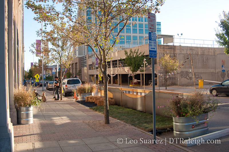
  • Open spaces, parklets, etc.
  • Variety of housing options
  • Abundance of experiences

Importance was placed on making Raleigh unique rather than playing “catch up” with other cities. We’re at a good point in our growth period as we’re not overbuilt and don’t have old, obsolete systems in place that may hinder bringing in the new.

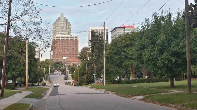
Accessibility was also emphasized. Downtown is great but there is more to the city than just that. Connections to and from downtown Raleigh are important so that all Raleigh denizens can take in the planned experiences.

The vision from the downtown plan’s advisory committee is to celebrate Raleigh as a hub of innovation, creativity, and entrepreneurship while maintaining authenticity and inclusiveness unlike any other city in the world.

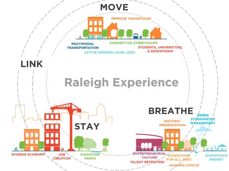
Breathe, Move, Stay, Link


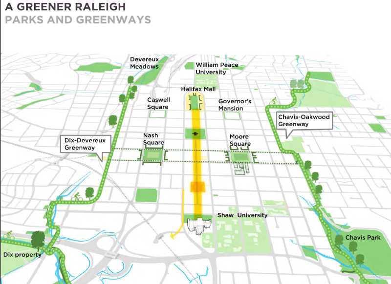
“Breathe” is the theme for creating 21st century parks, open spaces, and trails, just to name a few, that allow people to relax and enjoy the city. Focus on Nash and Moore Square as well as greenway trails through Chavis and Oakwood to the east and Devereux Meadow and Dorothea Dix to the west are proposed.


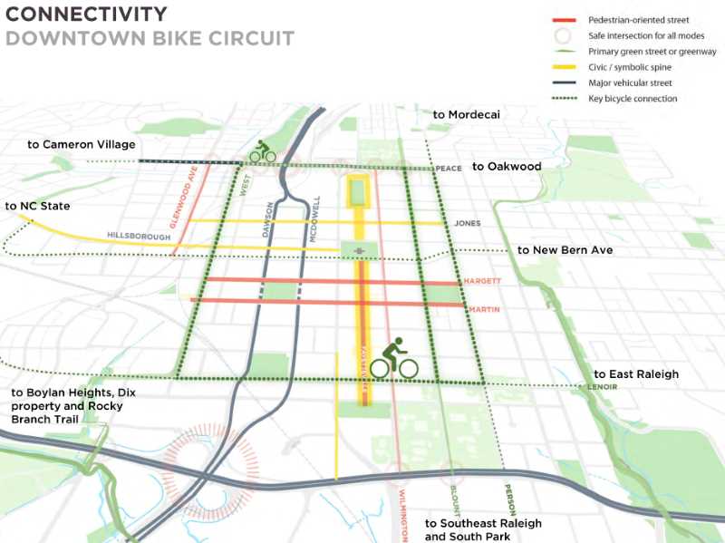
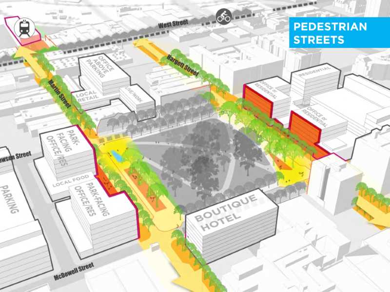
“Move” describes making over downtown Raleigh to be a model for walking, biking, and transit. Martin and Hargett Streets are identified as key pedestrian corridors and a downtown bike circuit is proposed as well.


“Stay” refers to downtown’s culture and being the tourism anchor of the city. This theme will be paired with the future growth opportunities covered below.

And finally “Link” talks about partnering with neighbors in our city. Universities, private business, non-profits, and many others also have a stake in our growing downtown. They should be at the table if not already.

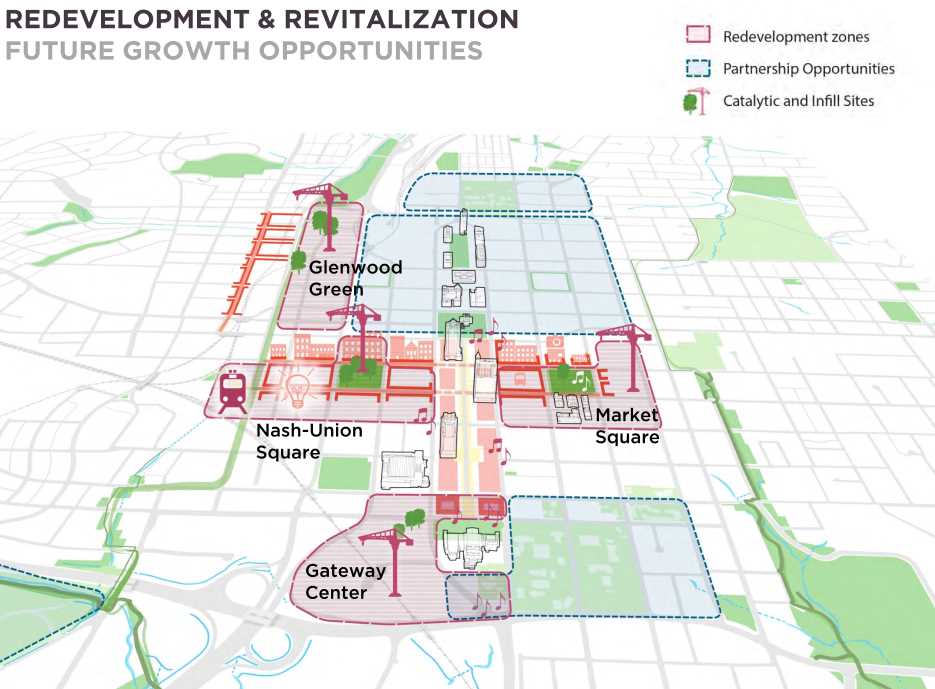
Four Catalytic Priorities


Nash-Union Square is the term for the area around Nash Square and the upcoming Raleigh Union Station. Transit-oriented development and pedestrian streets will be key to bringing new growth to this area. Ground-floor retail and improved streetscapes are tools to help make it happen.

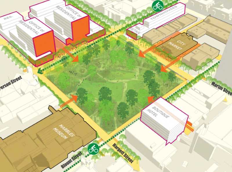
Nash Square is seen as an urban park oasis rather than the underutilized space that it is today. Activating the edges of the square will be important especially along Martin and Hargett Streets.


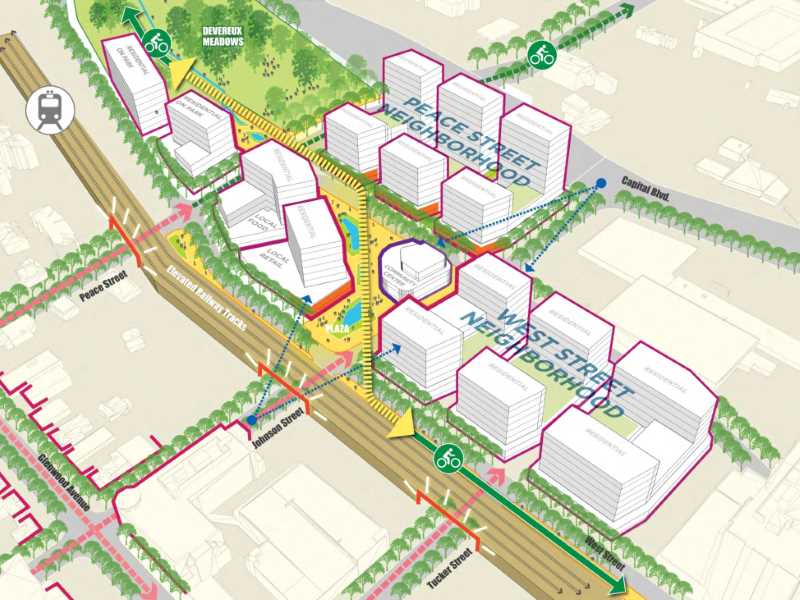
Glenwood Green is described, almost exactly, as new development for what used to be the old Smoky Hollow neighborhood before the “Urban Renewal” wave of the 1950s and 1960s cleared out this neighborhood. The area to the east of Glenwood South to Capital Boulevard could see new development around an urban greenway, parks, and urban residential buildings.

The plan suggests creating a park at Devereux Meadow as well as making new connections to the east and the south. With a possible light-rail connection nearby, this area could really be the residential epicenter of downtown.


Market Square is a fusion of City Market and Moore Square. Rather than make these two landmarks individual locations, the plan suggests to create a single area that encompasses both assets.

The plan suggests to turn the area into the premier, destination-oriented market with links to the nearby neighborhoods. The plan does tell a little of what we already know and should work on. The City Market building is underutilized, implementation of the Moore Square redesign should take place, as well as the improvements to the Moore Square Transit Center.


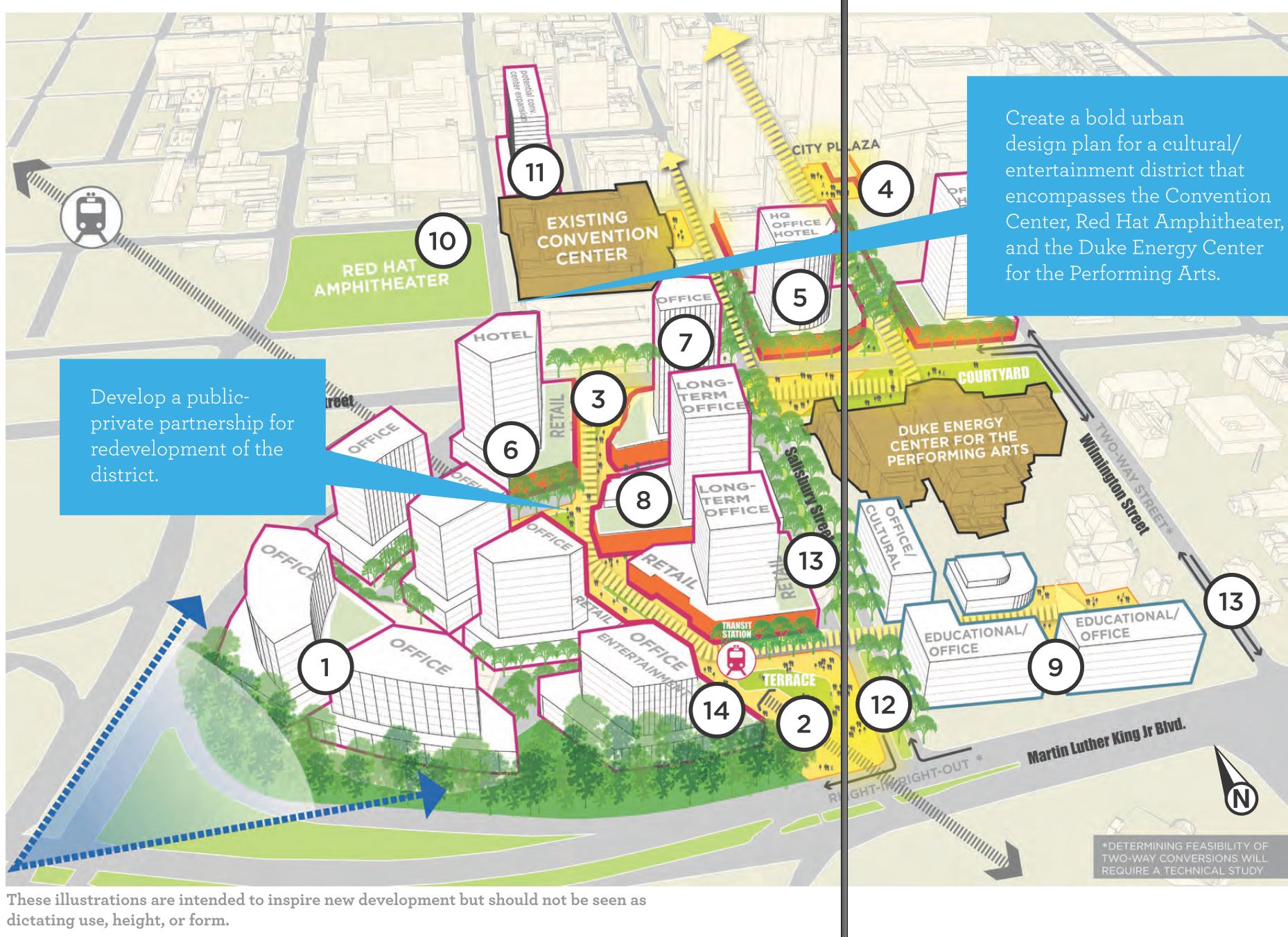
Gateway Center may be the grandest proposal in the plan. This involves the very suburban-like area to the south of the convention center adjacent to Martin Luther King Boulevard and South Saunders Street. The plan calls for pure development in this spot for a mix of uses including tourism, cultural, entertainment, and commercial.

Two big ideas are the one shown above, a campus-like setting with offices, educational institutions, and other innovation supporting entities. A second proposal in the plan shows a sporting venue wrapped with supportive retail and mixed-use development.

The R-Line

The plan presentation goes over the current state of the R-Line and possible changes to it that could address concerns. In the plan, we have:

  • Develop an optimized R-Line route to better serve existing and future Downtown riders
  • coordination with ongoing CAT system evaluation
  • Rider concentration is heavy at the Convention Center, Moore Square, and Glenwood South
  • Low ridership in the Warehouse District, New Bern, State Government, Seaboard, and Performing Arts Center

It looks like the plan wants to see the R-Line as part of a whole system, that being Capital Area Transit (CAT), rather than it’s own transit service. The new route proposals are for a shorter loop resulting in higher frequency and being complimentary to CAT bus routes.

East Cabarrus Green Street Project Brings More Sidewalks, Pavers, Peacefulness

East Cabarrus Street

East Cabarrus Street

Recently, I had the opportunity to dig into the details of the East Cabarrus Green Street Project. The city’s 2030 Comprehensive Plan includes a number of streets that have been identified as potential Green Streets and a section of Cabarrus may soon get some green upgrades.

A green street, according to the comprehensive plan, is described as one that has:

  • Pedestrian amenities
  • Landscaped planting strips where space permits
  • Wider sidewalks, bicycle lanes, and midblock crossings
  • Recommended speed limit maximums of 25 mph
  • LED street lighting
  • Innovative stormwater management facilities such as porous pavers, tree boxes, and rain gardens

All of Cabarrus has been identified as a green street in the comprehensive plan and today, there are plans for adding some of these green street items to a majority of East Cabarrus.

Starting at Wilmington Street and Cabarrus and moving east, the first plan will be to add bump outs to the intersection of Cabarrus and Blount as well as Cabarrus and Person Streets. A sketch of what that might look like is below:

East Cabarrus Street - Proposed bump outs at Blount Street.

East Cabarrus Street – Proposed bump outs at Blount Street.

The bump outs create a shorter crossing of the street for pedestrians as well as a safe place for seeing approaching cars. It also limits parked cars from being too close to the intersection, creating blind spots and potential close encounters.

This block, between Blount and Person, will also get permeable pavers where the on-street parking lanes are today. The permeable materials will filter rain water of any pollutants before reaching the ground water and therefore the nearby creeks. This is a pilot project that the city is working on and hasn’t installed something like this anywhere else so the results will be watched closely. Something similar are the sidewalks in front of the Nature Research Center or the parking lot for the AIANC building.

Continuing east, the stoplight at Cabarrus and Bloodworth will be removed and the intersection will be converted to a 4-way stop. With all cars stopping in any travel direction it makes for a more pedestrian friendly experience.

More sidewalks will be added also. The northern side of Cabarrus from East to Swain Street will get sidewalks in the public right-of-way. This is a nice addition for the Thompson-Hunter neighborhood as walking is increasing on the east side.

East Cabarrus Street - Sidewalks proposed for the northern side.

East Cabarrus Street – Sidewalks proposed for the northern side.

Finally, LED street lighting is planned for this section of Cabarrus. The hopes is that the brighter lighting will increase safety while saving costs on energy.

One final note to make is that this project spans both the Prince Hall Historic District and the Thompson-Hunter neighborhood. With the sections in Prince Hall, between Blount and Bloodworth, the Raleigh Historic District Commission (RHDC) will have to review the plans and issue a Certificate of Appropriateness for these changes. The items outside of those blocks can move forward without it.

Loose plans are to install these amenities throughout 2015.

Pic of the Week

Raleigh's first parklet at Salisbury and Hargett Street.

Raleigh’s first parklet at Salisbury and Hargett Street opened last week during the city’s Wide Open Bluegrass, an event that was part of the IBMA’s World of Bluegrass. They opened it up with live music and now the parklet is open for use.

Also, check out this fun video of the team behind the parklet putting it together. Congratulations to all of them and thank you for bringing something unique to downtown Raleigh!

Demolition Taking Place, Making Room For The Gramercy Apartments

Boylan Avenue, future home of The Gramercy Apartments

A project that has been a long time in the planning stages, since 2011, may soon start construction. The site for The Gramercy apartments along North Street is being cleared for the future apartment building. This involves demolition of the church at the corner of Boylan and North as well as the office building at the corner of Glenwood and North Street.

If the site plan hasn’t changed since we talked about it in 2011, the building will have 209 units and ground-floor retail all along Glenwood and some of North Street.

The resident wave just keeps crashing.

Boylan Avenue, future home of The Gramercy Apartments

Boylan Avenue, future home of The Gramercy Apartments

Color Codes Coming to Downtown Parking Decks

Parking is one of those services where having no complaints are a good thing and no real praise happens. I’m not sure enough people rave about how great a parking experience at a place is. So in hopes of less complaints, the city is color coding the downtown decks.

How will they do this? By placing colored signs at the entrances of course. The tweet above shows the signs that will go out. Our parking administrator sums it up:

“We hope the new signs make it easier for Downtown visitors to find their way back to their vehicles,” said Gordon Dash, City of Raleigh parking administrator. “Some visitors have experienced an hour or longer delay before they could find their vehicle, because they didn’t remember the name of the parking deck in which they parked. Color-coding also will make it easier for City of Raleigh Police and the Downtown Raleigh Ambassadors provided by the Downtown Raleigh Alliance to help visitors find their vehicles.”

It seems we’ve done such a good job at making the decks hidden with facades that look like buildings that enough people are forgetting where they park.

You could look at this two ways. It’s simply a “problem we want to have” or parking management needs to be rethought.