
Last week, I was in San Antonio for a few days and had an opportunity to check out the city for the first time. As well as seeing the town, strolling on the much talked about Riverwalk, and eating breakfast tacos I made a point to try out B-cycle, the bike share service with programs in multiple cities around the country. With over 40 stations in and out of downtown, I was determined to plan some sightseeing while on two wheels.
For some background, I recommend you watch the Raleigh Urban Design Center’s education forum about bike share in other cities which includes the B-cycle service.
I was staying near the convention center and did not rent a car for my trip. Using cabs to get everywhere would have cost me much more than I was willing to spend. Plus, the bus and trolley network had pretty good coverage and frequency to get around. Renting a bike however seemed like a great way to move at my own pace and stop when I wanted too.
San Antonio had temperatures in the mid-90s on the particular weekday that I tried out B-cycle and very little cloud cover. Still determined to try it, I got started in the morning and avoided the much hotter afternoon.
Getting Started
I walked from my hotel to the B-cycle hub located at the corner of Alamo Street and Cesar Chavez Boulevard. This little building seemed like the heart of the bike share program and anyone could go there for information, bike gear rental and sales, etc. Unfortunately, I arrived before they opened (9am-5pm on weekdays) and couldn’t go inside.
I needed to open an account with B-cycle before getting a bike so I sat outside and filled out the form on my smartphone. It wasn’t mobile friendly but a customer service rep that I later emailed with said they are working on that.
Here were my membership options:
- 24-hour – $10
- 7-days – $24
- Annual – $60
One day seemed perfect for my situation so I selected the $10 option and gave up the credit card info. I learned that the account is activated, and the clock starts, when the first bike is rented, not when you sign up. This is good to know so that you can get this part of the process out of the way ahead of time.
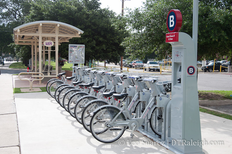
Renting a bike
Now that my account was set up, renting a bicycle was easy. Each station has a solar-powered touchscreen that guides you through the process. It’s about five taps and a credit card swipe from start to finish. You then pull your selected bike out of the station and you’re good to go.
The bike is a 3-speed cruiser with a basket on the front. There is also a bike lock provided and the seat adjusts pretty easily.
I next started my ride into San Antonio’s King William neighborhood followed by the Mission trail to my final destination, Mission San Jose. The ride was about 6 miles on street and a greenway along the San Antonio river. The map below shows my approximate ride.
View Leo’s San Antonion B-cycle ride in a larger map
B-Cycling Away
At this point, if you have ridden a bicycle before, it was pretty much the same thing.
Along my ride, I spotted many of the other B-cycle stations. The route I chose was mainly on side streets and mostly had bike lanes so riding was easy. San Antonio is also pretty flat so I wasn’t struggling up any hills which I sometimes encounter here in Raleigh.
(For the record, I’m in decent bike shape but not an all-star by any means)
I felt that the cycling experience was now in the hands of the city. The route I chose went through a few parks and I stopped twice to get water from public water fountains. The presence of bike lanes was very welcomed and I felt comfortable on the streets. This could have been different on someone else’s route however.
Returning the bike
I finally made it to Mission San Jose and the visitor center had a station right in front. Returning the bike is dead simple. You find an empty slot and glide the bike right into it. The station beeps and turns green when the bike has been set in properly.
That’s it.
One thing I had to look up out of curiosity would be what to do if the station was full and there were no empty slots to return the bike. B-cycle’s official answer to this is:
If you have a bike checked out and wish to return it, but there are no available docks at a station, you can use a web browser (www.sanantonio.bcycle.com) or iPhone app to locate available bikes at nearby stations. Also, if you approach the kiosk at a full station, the kiosk will provide information about nearby stations with available docks, and you can also get 15 free minutes added to your ride so you can take the bike to an open station without incurring additional usage fees.
There is a system map located at each station.
They don’t mention it in this FAQ excerpt but there is an Android app as well which is what I used to find nearby stations.
Final Thoughts
As mentioned earlier, I encourage everyone to jump to the Urban Design Center video about bike share in other cities with some nice discussion following it.
Before this trip, I was on the fence about bike share in Raleigh. I felt that we should continue spending more time and money on bicycle infrastructure with bike share coming later. I am a little more convinced about it though after trying it but still feel that Raleigh needs to plan, retrofit, and build more bicycle friendly streets before stations are put in.
First, it would be advantageous to plan for bike share now. We could identify possible station and hub locations, create design guidelines for sidewalks and streets around them, get neighborhoods thinking about where stations could be placed along their streets, those kinds of things. With these in place, when we’re ready for bike share, we’ll be prepared.
With this kind of preparation done, I also feel that a sizable network should be rolled out instead of a small system just to ‘test the waters.’ The success of the bike share system, in my opinion, is based on how comfortable riders feel their options are in station locations. If the city decides to implement bike share with only 5-10 stations then adoption will be much slower and it hurts any case for expansion.
Seeing several B-cycle stations around San Antonio was comforting and gave me confidence in the system. The same should go for any city that wants to do the same.
One thing that doesn’t quite make sense to me is the placement of these bike share stations. All of the stations that I’ve seen, across multiple cities, have been on the sidewalk. I feel they should be right on the street, similar to how a bike corral is placed on the street.
Just like the Hargett Street bike corral occupies some space on the street (not the sidewalk) a bike share station should occupy space along a street. Bicycles, after all, are treated like vehicles on the road and should therefore park like them as well.
On a later ride on B-cycle, I was riding down Market Street, looking for the station in front of the convention center. I didn’t see the station because it was partially hidden behind parked cars along the street. Better signage (just like cars get with larger street signs, parking signs, etc.) should be placed for bicycle riders who need to know that a B-cycle station is coming up and whether it is on the approaching left or the right.
Bringing it to Raleigh
I haven’t looked at them all but a few bike share systems that I have seen have been backed by private funds. This helps implementation happen much faster so until a private company around Raleigh is willing to put up funds for this, we’ll have to wait until it’s a sound public investment.
While other programs exist, B-cycle has a ‘Who wants it more?’ page where you can vote to bring B-cycle here. Right now, we’re ranked #67 with 489 votes. Vote here.
Don’t put too much stock into that though as Charlotte, who has a B-cycle system, ranks #67 (464 votes) while Asheville ranks #7 (31,344 votes) and does not.
Just keep pedaling, Raleigh.


