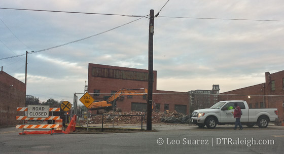
Demolition was taking place last week in front of the future Raleigh Union Station site. The smaller warehouse in front was planned to be removed for a grand entrance plaza for the train station. Below is a rendering of that entrance plaza.

Demolition was taking place last week in front of the future Raleigh Union Station site. The smaller warehouse in front was planned to be removed for a grand entrance plaza for the train station. Below is a rendering of that entrance plaza.
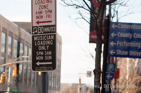
A few of downtown’s music venues have this new parking zone out front for musicians.
I wanted to share the feedback I submitted about the Wake County Transit Plan, which all readers should take a look at. I think a whole discussion could come about the idea of an invisible east/west barrier that goes right down Raleigh. I am hoping that an upgrade to transit could break down that barrier and really expand mobility choices and access to all areas of the city. Does anyone else see these barriers to mobility around our city? -Leo
Feedback
Hello,
I’ve taken a good look through the latest Wake County Transit Plan update and wanted to share some thoughts I had about it. I’ll admit that this may be more detailed than the document shows but maybe it is something that the planning team could consider.
I believe there is this invisible “divide” between east and west Raleigh, where Capital Boulevard, McDowell/Dawson in downtown, and South Saunders create a sort of barrier. Going from parts east to west, and vice versa, by any travel method meets a “resistance” when you hit this divide.
Driving a car across Raleigh, the options are slim due to Capital Boulevard’s lack of cross streets, downtown’s more urban nature, and south Raleigh’s lack of east/west streets. Cycling is in a similar situation. Currently, none of the GoRaleigh bus routes go between east and west Raleigh but rather terminate in downtown’s Moore Square Transit Station for a transfer.
I see this Transit Station as contributing to that same invisible barrier.
My feedback as part of this new transit plan would be for the planning team to discuss this and see if transit could break through this barrier and connect east and west Raleigh more directly. For example, a bus route that does not stop in downtown Raleigh but uses both Hillsborough Street and New Bern Avenue/Edenton Street.
Thanks a lot ahead of time and I very much look forward for the successful implementation of this plan!
Response
Mr. Suarez
Thanks for taking the time to review the Recommended Wake County Transit Plan and for submitting your comment.
Your comment fits very well within the key goal of the Transit Plan to make transit “useful” to as many people as possible. Divides and barriers, real or perceived impact how and if people use transit and the focus of the transit plan is to address and solve these types of issues.
The project team has specifically looked at BRT and bus line corridors that flow through rather than to downtown. The New Bern Avenue to Morgan St /Hillsborough Street alignment has been specifically studied. That said, there are different perspectives on how BRT should flow through Downtown Raleigh and connect with the various destinations. The perspectives differ in how radically they would change existing streets, how vehicles would interact with bus stations and how the different BRT corridors would interact with each other. Moving forward we hope to have a clear community dialogue on the options, benefits and costs of the various ways to implement the different projects shown in the recommended transit plan. We anticipate this dialogue will be open to public ideas and reactions on solutions.
Some of the service realities we are asking decison-makers to consider are: (these parallel your comment)
1) As vehicle frequency increases there is less need to stop and wait at big stations and street based platforms (that allow vehicles to keep moving) make more sense.
2) Routes work best by collecting and combining multiple trips – routes that stop in downtown rather then flowing through downtown limit their usefulness for certain trips.
3) Frequent routes tend to be used for shorter trips and riders on shorter trips tend to have a low tolerance for delay (i.e. they will switch to other modes).
Please keep in mind that the transit plan is positioned to provide vision but also to allow a start and evolution approach if that is needed or best for the community. One question we asked staff from all of our partner agencies to answer on each of the projects was “are there multiple ways to accomplish that and still meet the goal?” The recommended transit plan takes this approach not to get “watered down” versions of everything but to keep an eye toward the larger goal and allow the system to change as needed as community perspectives change. National and local positions on transit, what street should be used for, and what creates a great place to live are changing and evolving in ways we have not seen in previous decades and these positions may/will likely continue to evolve.
If you have further questions on the Recommended Wake County Transit Plan please respond to this email, call 919-856-5477 or visit www.waketransit.com
Not a breaking update but rather, here’s what we know so far. I walked by the site recently and still nothing new since the groundbreaking took place in May. (that’s seven months ago)
It seems we’ve been going through a financial obstacle course with this project. All interested should jump to the project page on the city’s website where you will find this piece of information:
At the March 3, 2015 Council meeting, the Construction Manager at Risk (CMAR) team was authorized to proceed with bidding and finalization of a guaranteed maximum price (GMP) not to exceed $44,737,870.
In July and September of 2015, bids were received on the project which exceeded the estimate. The bid yielded a GMP of $60,000,000, which yielded a project gap of $15,300,000 when compared to the March estimate. Value engineering and steel rebid resulted in project savings, lowering the GMP to $54,700,000, leaving a $10,000,000 gap. Project partners have addressed the funding gap by identifying scope reductions totaling approximately $2,900,000. Remaining additional funding of $7,200,000 is required.
Various options were presented to Council at the Work Session on Oct. 20 and at the Nov. 3 City Council meeting, full funding, no scope reduction for Raleigh Union Station was approved with gap funding of $7,200,000, and a revised total project budget of $54,700,000.
*Union Station: Raleigh’s Multi-Modal Transit Center
The way I read it is that they wanted to do the project for about $10 million less than anyone was willing to do it for but in November, they figured it out.
Let’s have a good holiday season and then build a train station!
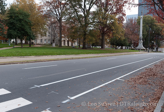
Fresh paint on Hillsborough Street.
In mid 2014, I did a post about the evolution of Raleigh’s bicycle network. It’s been years, it feels slow-moving, but the pieces may be starting to connect and create this thing called a “Network”. I got really into looking at the maps in the latest draft chapter of the Raleigh Bike Plan Update. The complete document should be done before the end of the year and some of the material is available now.
Dive in to the Raleigh Bike Plan Update.
Looking at Chapter 3 shows the recommended network. It includes 126 new miles of greenway, 149 miles of new protected bikeways, and 277 miles of new bike lanes. The full breakdown is in the below table.
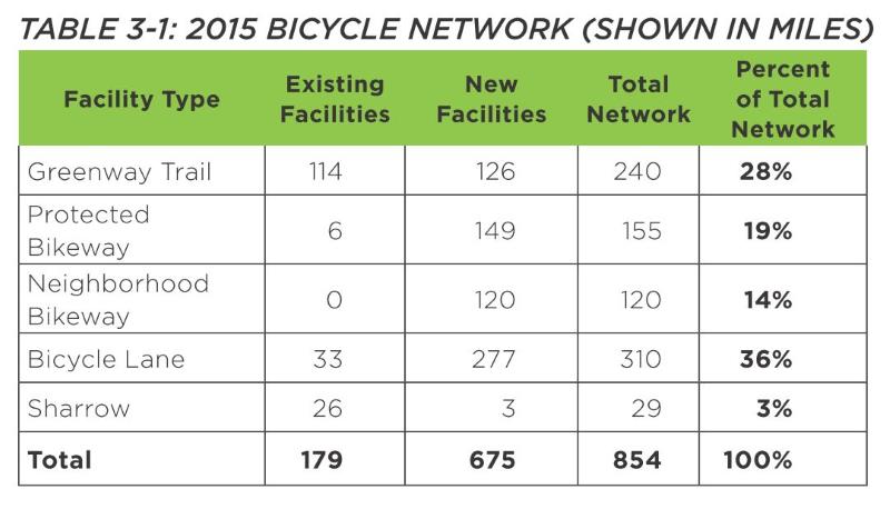
It’s great to see so little sharrows being planned as, in my opinion, they don’t do very much. The recommendation is for more than three times more miles of bike facilities versus what we currently have. That’s a big ramp up in expanding the “Network.”
Protected bikeways are a huge step in the right direction to get riders on to the network. A protected bikeway is described as such:
This plan update defines a protected bikeway as a bicycle facility that is physically separated from motor vehicle traffic within a street corridor. For this Plan, this includes cycle tracks and buffered bike lanes, in addition to the City’s shared-use path and greenway network. The on-road physical separation can be achieved through parked cars, curbs, medians, bollards/traffic posts, planters, or marked buffered space between the bike lane and adjacent travel lane.
The one catch that I don’t like about greenways is that they have, historically, been seen as recreational paths versus effective transit routes. In only a certain amount of cases does a greenway help someone get from point A to B faster than a street.
Speaking of Point A to B, the chapter shows us the recommended network on a map of Raleigh. I decided to take a look at five possible routes starting from downtown Raleigh and seeing how the bicycle network of the future would accommodate versus today.
I have a deep hope that the Raleigh of the near future can make all of inside-the-beltline a bikeable haven for residents to easily zip around on. The network should get folks from their homes to any major destination easily.
I’ve included a doctored-up screenshot of those maps with each route.
Downtown Raleigh to North Hills
From one urban center to another, getting to North Hills and back by bicycle would be a fantastic way to move around. Today, the greenways are just too far away and don’t provide a direct enough route. With Capital Boulevard being a huge east/west barrier, getting to St. Mary’s Street is the best option. Heading North, the ride should cross over to Lassiter Mill Road where it will take you to North Hills.

Click for larger
Currently, both of these roads have bike lanes and sharrows for almost the entire route with some sections unmarked. According to the draft plan, a new protected bikeway would go in starting north of Peace Street but wouldn’t be that long. (up to Wade) Along with some new sharrows on Lassiter Mill Road, there’s not much improvement on this route.
Downtown Raleigh to Five Points
The closest two destinations in this list, getting to Five Points is pretty much a ride up Glenwood Avenue. Today, there are no bicycle facilities between Five Points and Glenwood South. The two-lane road isn’t so difficult but that does mean you need to be comfortable riding in traffic.
Sadly, the recommended network has nothing planned for Glenwood Avenue here. Instead, a new route will go in along West Street. A protected bikeway/greenway trail, which we’ve covered before, is recommended form the Warehouse District all the way to Wade Avenue. The route will split with a greenway going northeast along Capital and sharrows along Fairview Road. That will lead you straight into Five Points.

Click for larger
This will be a great north/south connection and I’m interested to see if it’s possible to add a connection, somehow, to this greenway along Capital Boulevard from the eastern neighborhoods, like Mordecai and Oakwood.
Downtown Raleigh to Crabtree Valley Mall
Ride to the mall? It’s probably better to just take the bus. Route 6 is a direct shot from downtown Raleigh to Crabtree Valley Mall. You can’t get more convenient then that. Still, riding your bike adds a little freedom. I’ve done this once with the intent to get some exercise and do some shopping. It’s not for every day though but maybe it is for some.
Today, Glenwood Avenue towards Crabtree is pretty hectic and there are some bike lanes but only for a small portion of the route. The recommended network adds protected bike lanes north of Glenwood/Oberlin. Taking the route to Five Points would be how you start. You then would most likely continue north on Fairview, get to Oberlin where bike lanes exist today, and take Glenwood north on the new protected bike lanes.
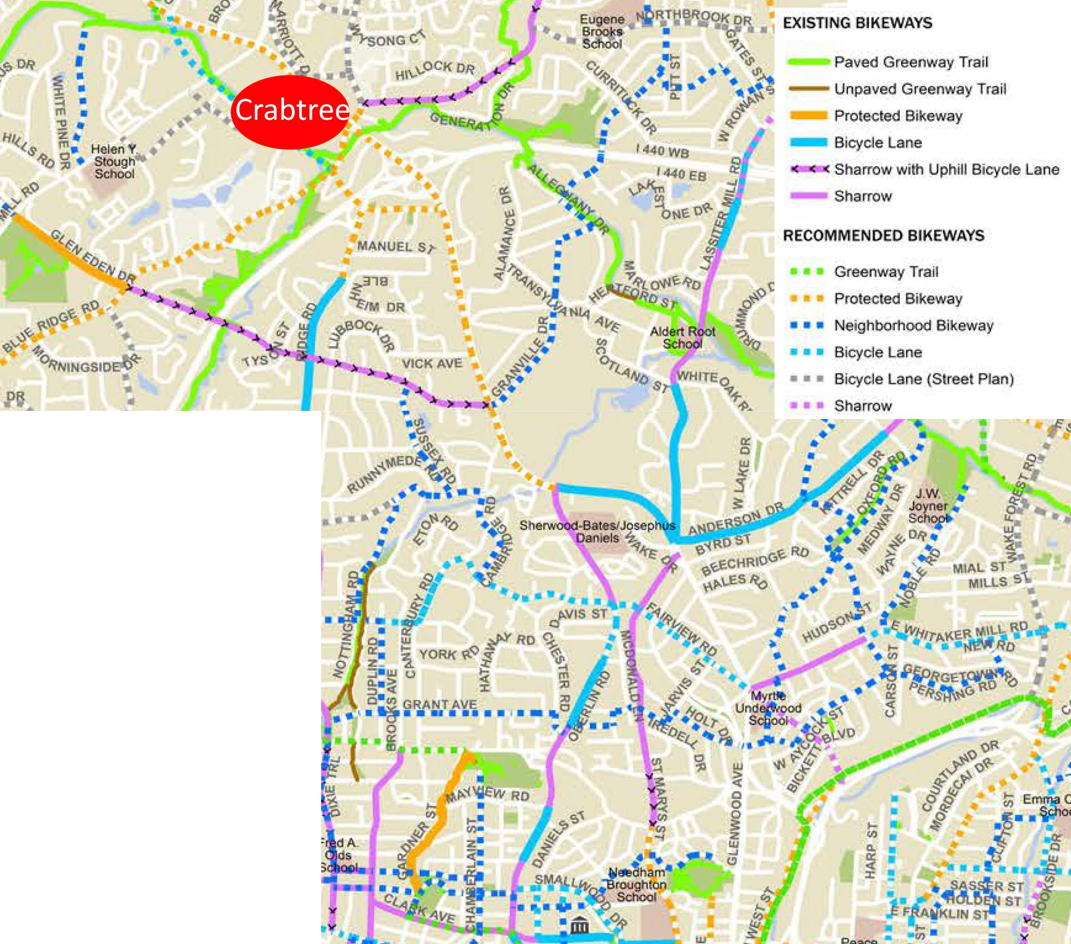
Click for larger
This is a big improvement. The challenge though is pulling into Crabtree Mall once you are there. It would be fantastic to see the spaghetti bowl in that area cleaned up but an easy fix might be a bicycle “off ramp” onto the greenway that goes underneath Glenwood Avenue and goes to the Crabtree Valley Avenue entrance.
Downtown Raleigh to the Fairgrounds
Hillsborough Street is so direct, so straight that using it for cycling transit would be really tempting when going west. Up until just this week, we now have bike lanes starting from the Capital building mostly going up until NC State University. Currently, it then fades out for now but the two lanes west of Faircloth Street might makes things manageable for biking without any lanes.
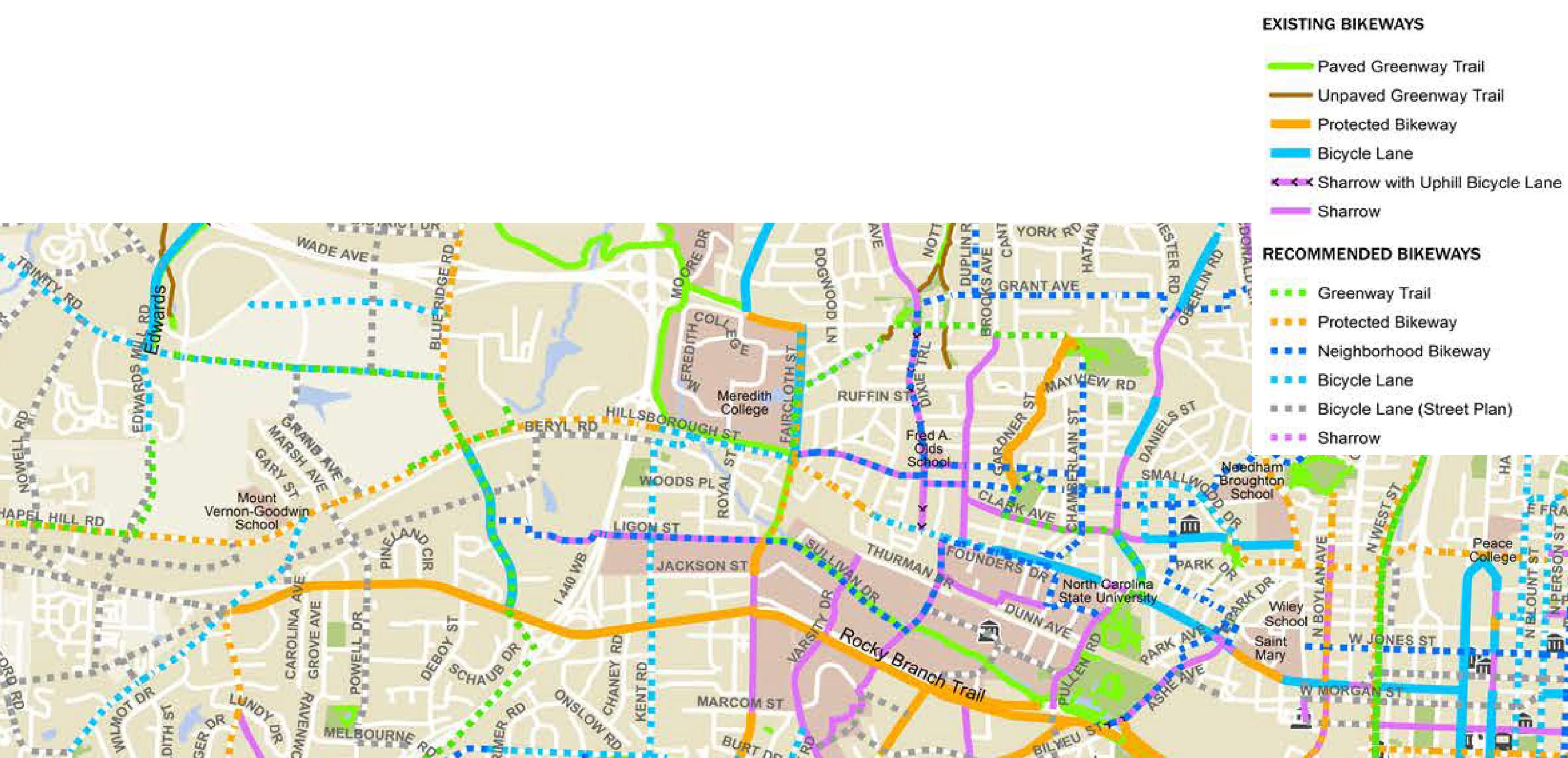
Click for larger
The recommended network continues the bike lanes in front of the university and uses a combination of protected (mostly) and bike lanes to get to the fairgrounds. The plan is actually to extend them all the way out to I-40.
This is a huge improvement for connecting to West Raleigh.
Downtown Raleigh to the Farmer’s Market
Today, getting to the Farmer’s Market by bicycle isn’t the mot difficult as you have a few options. The longer but safest route is by greenway but a few residential streets could get you out there faster without the need for bicycle facilities. Still, a straight shot would be most ideal and that most likely means that Lake Wheeler Road needs a makeover.
Click for larger
It is great to see a protected bike lane on the recommended draft map between the Farmer’s Market and downtown Raleigh along Lake Wheeler. A protected lane is probably best as Lake Wheeler has some nice hills and is pretty direct.
Great improvement here.
Wrap Up
For me, connecting major destinations together in a more direct route is what I’m looking for in bicycle improvements. Since this is a downtown Raleigh blog, that’s the approach I took in these five routes.
As always, the draft bicycle plan is still a work in progress and you can submit feedback on what you see up there.
Municipography is a summary of current issues going through the Raleigh City Council and other municipal departments in the city. The point is to try to deliver any video, photos, and text associated with the discussions happening at City Hall or elsewhere. Since this is a downtown Raleigh blog, the focus is on the center of the city.
I recommend email readers click through to the website to see the embedded video.

Parking in downtown Raleigh is being discussed once again. If you haven’t heard yet, this latest city budget added some new fees to our downtown decks at times that were previously free.
Please keep in mind that this only applies to the city-owned parking decks that predominantly are located in the core business district. There are no city-owned decks in the warehouse district or Glenwood South, for example, so this wouldn’t apply to anything in those areas. State, county, and private decks do their own thing but with the city owning eight decks total, this change is big enough to take note of.
A quick side note. This change does not apply to the convention center deck, the performing arts deck (that one to the south of the convention center), and the Blount Street deck so only five of the eight city-owned decks would have the new changes.
To start things off, I went straight to the budget and found a few interesting snippets.
In order to better support the maintenance and cleanliness of the decks, a flat $5 night and weekend parking fee is included in the budget and will take effect December 31, 2015. This new fee will fund a dedicated cleaning crew, equipment upgrades, and additional staffing for the parking attendant booths.
– Page 10
Implementation of night and weekend paid parking is expected to generate $950,000 in revenue during the initial six month period beginning December 31, 2015. This revenue will offset the cost of a dedicated janitorial crew to provide 24-hour coverage for cleaning and sanitizing the parking decks ($250,000 for first six months). Funds are also budgeted for increased contractual services to staff the parking decks during the night and weekend hours ($250,000) and to upgrade parking deck equipment and software ($450,000).
– Page 127
Some additional actions listed in the budget here are:
Work with McLaurin Parking to sub-contract a janitorial crew of 12 workers dedicated to cleaning and sanitizing the parking decks to address the challenges of increased nighttime and special events activities in the decks.
Begin priority structural repairs in the Wilmington Station, City Center, Cabarrus and Performing Arts Decks based on priorities identified in the 2013 Kimley-Horn Deck Assessment Report.
Engage a consulting firm to conduct a parking study of current parking space inventory, space commitments and future obligations and provide recommendations for new deck locations and capacities on the east and west sides of downtown. This study is essential for the city to maintain an available parking supply that can accommodate the demands of new business development, downtown residential life and the increasing number of downtown activities.
– Page 127
The proposed $5 flat fee would go into place 7pm-7am every weeknight, all-day Saturday, (that’s up until 7am Sunday morning) and after 1pm on Sunday. This plan is already approved per the budget.
The daytime worker versus the nightlifer is a bit different and it seems the decks are getting pretty dirty with this rise in nighttime use. The current funding model is seen as outdated for handling today’s use of the city’s decks and a change is needed.
A group of downtown business owners have gotten together and are trying to work with the city. They see the proposed change as too drastic and want to see the hours reduced and/or a phase-in approach take place.
Below is the presentation to the city council from Public Works about the changes and some follow-on discussion. If you can’t see the embedded video, click here.
Unfortunately, some raw numbers would have made this presentation great and allowed us to have some data to play with. There was a bar chart shown but the point it was trying to make wasn’t too clear so I won’t share that in this post.
It’s irrelevant though as most of us can agree that Friday and Saturday are seeing increased parking deck use, some filling up completely, and we’re capturing no revenue here to offset the needed repairs and keep them clean.
As a city, we’ve decided to run our parking as an enterprise fund. In short, that means it has to pay for itself. By that adopted process, we must explore ways to get more revenue flowing as the fund is currently in the negative.
In addition to paying off debt, what I’m most interested in is what the new visitor experience will be like as a result of this $5 flat fee. Currently, six staff members are in charge of the eight city-owned decks. They take care of maintenance and cleaning. With the added fees, this number would increase to 12, according to the presentation.
Does that result in a better looking, better operating facilities or are we just keeping pace? That’s yet to be seen.
A compromise between the approved plan in the budget and the downtown business owners that think this is too much, too fast was looked at. A number of alternatives were put together, changing hours, changing the fee rates. The preferred alternative from city staff looks like this:
Note the weekend enforcement drops Sunday and goes from Friday night through Saturday until the early morning hours of Sunday. Saturday all-day hours seem to be the key capture time here and revenues from Sunday to Wednesday night are not that significant.
In addition, the decks would be color-coded to help in locating the deck that you parked in, (a common complaint by the way) reduced monthly spaces for downtown employees, and a special program with Marbles Museum for complimentary parking.
Here is a breakdown of some nearby cities and what they charge in downtown on nights and weekends.
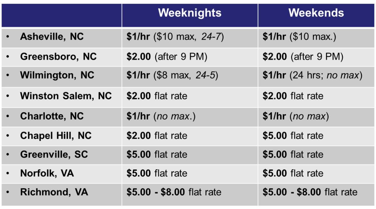
A $5 flat fee, when compared around the state/region, is not ridiculous by any means. Still, some feel that the fee would deter visitors and be yet another obstacle for retail in downtown to grow.
Personally, I welcome this $5 flat parking fee during our busiest nights and weekend days. I even think Sunday should be included. What I hope to see in exchange are spotless parking decks, well-designed wayfinding, new elevators, and top-notch customer service. (in-person and through technology) People are willing to pay if the experience is very positive.
I even think on-street metered parking should continue to run, that way parking in a deck is more attractive and removes congestion off the streets.
If the city won’t do it, we’re just making private parking decks and lots more likely to rise up. The conversation on this topic continues, at the city council, during their Nov 3 meeting.
We hear it time and time again. “There’s no parking in downtown Raleigh.”
With so much technology around us, why aren’t we making this parking thing a lot simpler?
I worked with members of the Glenwood South Neighborhood Collaborative (GSNC) on a very helpful web app to guide visitors around parking in Glenwood South. There are actually a lot of spaces right off the main strip in the district that people are not taking advantage of. You can even use your phone to pay for your space.
We compiled all the info and are running it on the GSNC website so I encourage all readers to check it out.
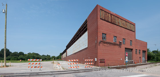
This past weekend, I stepped out onto the end of Martin Street real quick to see if there was anything going on at the Raleigh Union Station construction site. The photo above was taken on Saturday and shows no visible signs of construction. (except the street barricades)
Perhaps last minute plans are still being worked before crews start making progress. I remember that the new station will be funded through a variety of funds coming in different directions so maybe that’s a slow process.
It just seems to be taking longer than expected seeing as how the first groundbreaking announcement was for March 2015 only to be delayed until May 2015. Here we are in July and still waiting.
Staying positive still at this point though.