Upcoming Urban Design Center Education Forums

The Raleigh Urban Design Center has a new schedule of urban-related lecture forums and they stick with the theme of, “Raleigh 2025 – What’s Downtown Got To Do With It?” Last season, there were some pretty good ones related to bike sharing, downtown living, and open space. Here are some that you can watch again.

Lecture Forums

Urban Design Center
220 Fayetteville Street
12 Noon – 1:30 pm

While adding these events to my calendar, I decided to tweak them so I could share them with readers. Here are the XML, iCal, and HTML links for sharing. Hopefully they work with your personal calendars.

The events are all free and take place during weekday lunch hours. Go over to the city’s website to see all the topics but here are a select few that really focus on downtown Raleigh.

The Great American Downtown – 2025
October 23, 2013
Mitchell J. Silver, Chief Planning & Development Officer and Planning Director, City of Raleigh

  • What is the experience of place in great cities of the future?
  • How can Raleigh make it happen?
  • Who will be living in Raleigh in 2025?

Jobs + Talent 2025
December 4, 2013
James Sauls, Director, Economic Development, and Derrick Minor, Innovation and Entrepreneurship Manager, City of Raleigh, Economic Development Department

  • What types of industries are we trying to grow locally and recruit nationally?
  • How important is talent recruitment and retention to a community?
  • How do you establish a culture of innovation and creativity?

Back to the Future in Raleigh
February 12, 2014
Eric Lamb, PE, Transportation Planning Manager, City of Raleigh

  • How will people move in the City of Tomorrow?
  • How will the evolution of technology change the way we need to travel?
  • Are there places around the world today where we can glimpse the future?

Population Growth, Sustainability, and the Need for Urban Greenspace
April 23, 2014
Danesha Seth Carley, PhD., Assistant Professor, Department of Crop Science, NC State University

  • Is there a place for “green space” in the city of the future?
  • How can we increase and protect our green space and what value does that bring to our community?
  • How will the city be feeding itself in an era of diminishing resources and increasing carbon footprint?

Downtown: An Engine for Wake County’s Tourism Strategy
May 21, 2014
David Diaz, CEO, Downtown Raleigh Alliance, and Julie Brakenbury, Director of Services, Greater Raleigh Convention and Visitors Bureau

  • What is the role of a downtown in attracting visitors?
  • What are downtown Raleigh’s key strengths challenges as a center for tourism?
  • How does the visitor bureau quantify the economic impact of downtown Raleigh’s tourism assets?

Blount Street – Person Street Corridor Study Approved, Plans For Walkable, Livable Streets

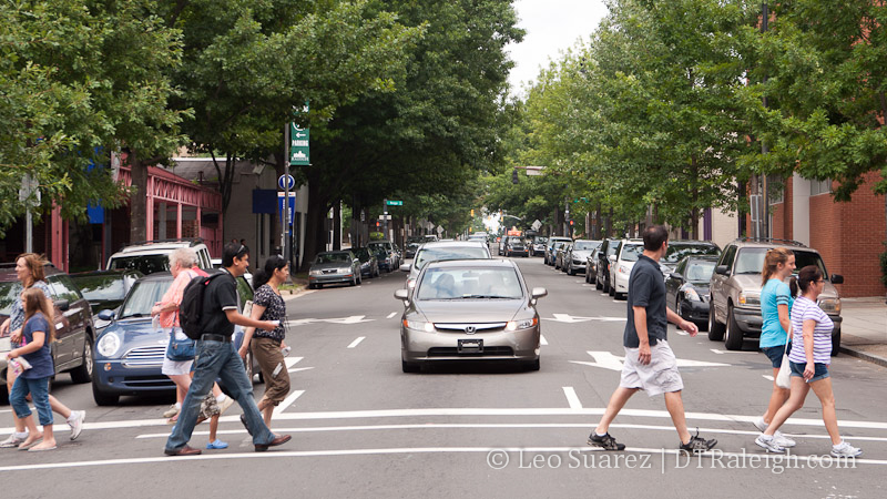
Blount Street at Hargett Street

Blount Street at Hargett Street

On July 16, 2013, the Raleigh City Council approved the Blount/Person Street Corridor study. The project that includes the two streets from Capital Boulevard down to I-40 along Hammond Road has been ongoing since October 2012. The result could be more multi-modal streets that are phased in as funding becomes available.

There are well over 1000 pages of analysis, renderings, and overviews on the project, all available on the city’s website. I thought I’d take the time to skim through and put some highlights of the project here on the blog.

One important thing to be aware of is that funding for Phase 1 is included in the Transportation Bond coming to this October’s ballot. That will pay for a re-striping project of Blount and Person Streets that lays the foundation for the One-Way Road Diet plan.

Read on for more details.

Overview and Project Area

As mentioned earlier, the project area starts in the north along Atlantic Avenue near Capital Boulevard, continues down Wake Forest Road to the one-way pairs of Blount/Person Streets and ends at Hammond Road through I-40.

Below is map of the area taken from the documents. It’s a lengthy map so click to expand/collapse it.

Map of the Blount/Person Street Corridor Study

Map of the Blount/Person Street Corridor Study

During the July 16 city council meeting, Grant Meacci from city planning gave an overview to the council. You can watch it in the video below.

One-way versus Two-Way

The report’s findings are based around some high-level themes which include:

  • A Complete Street – “The corridor has the potential to encourage and serve a wide range of users,”
  • A Functional Street – “The corridor provides valuable and needed access to Downtown Raleigh, adjacent
    neighborhoods, and major regional destinations”
  • A Vibrant Street – “The community envisions a thriving corridor with a wide range of housing, shopping and working opportunities.”
  • A Beautiful Street – “A beautiful street is the result of continued investment in streetscape, tree planting, and street character.”

With these themes in mind, two design alternatives have come out that could accomplish the goals of the study.

  1. One-Way Road Diet
  2. Two-Way Restoration

In addition to studying both of these alternatives, the report states that they should not be seen as mutually exclusive but rather steps towards achieving the vision for the corridor. So for example the one-way road diet could be put in now but later, after feedback from the community and further analysis, the two-way restoration could be implemented.

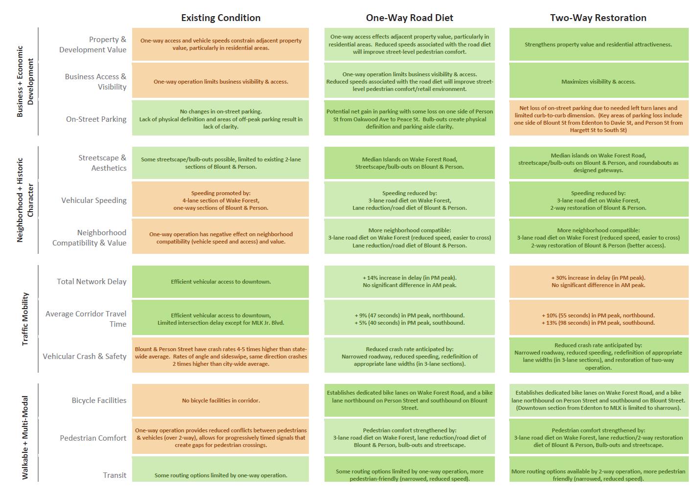
The report has a great one-page comparison chart that states the potential negative impacts as well as benefits of each approach. Click on it below to see it larger.
Alternatives of Blount/Person Street Corridor Study

Alternatives of Blount/Person Street Corridor Study

To make this all happen, 3 phases are proposed.

  1. Road Diet Restriping – 4 sections along the corridor ~$730,000 (To be on the Oct 2013 Transportation Bond)
  2. Streetscape – 3 section along the corridor ~$7.47 million
  3. Two-Way restoration – 3 section along the corridor ~$4.17 million

The sections are broken out so it looks possible to fund them in even smaller steps if necessary.

Details and Renderings

Public participation was a key part of this project and hundreds of ideas and comments were submitted. The report has an exhaustive list of comments that were organized into themes, the ones that helped shape the ones mentioned above. Here are a sample.

Business & Economic Development

  • Safe access to business
  • Vibrant community business district
  • Local Independent businesses
  • Thriving businesses that are accessible by peds, bikes, and cars
  • Support growth of small neighborhood (walk to businesses)

Traffic Mobility

  • Slow traffic speeds
  • Alternative parking solutions
  • Connection to Downtown
  • Ease of grid design between sections
  • Easy access to BeltLine and I-40

Walkable & Multimodal

  • Traffic Calming
  • Ability to safely walk to venues
  • Walkable to Downtown, safe for children to roam
  • People Friendly environment
  • Reduce traffic, increase bus service

The report then gets into showing the different “layers” around the corridor including existing land use, popular destinations, open space, parks, and current redevelopment plans. This really shows you the mix of neighborhoods and historic resources that are present in this area.

No report is complete without a traffic analysis and the report has a mountain of information including traffic counts, travel time, and level of service. Looks like most of the downtown intersections show pretty good marks with the data taken in 2011.

The street design here is a mixed-bag of offerings with streets that have sidewalks and good urban form while others are lacking proper sidewalks. The worst areas were to the south near Bragg and Branch Street as well as to the north near Wake Forest Road and Atlantic Avenue.

For reference, each section’s current street design within the corridor has an accompanying rendering. For example, below is Blount Street from Edenton to South Street.
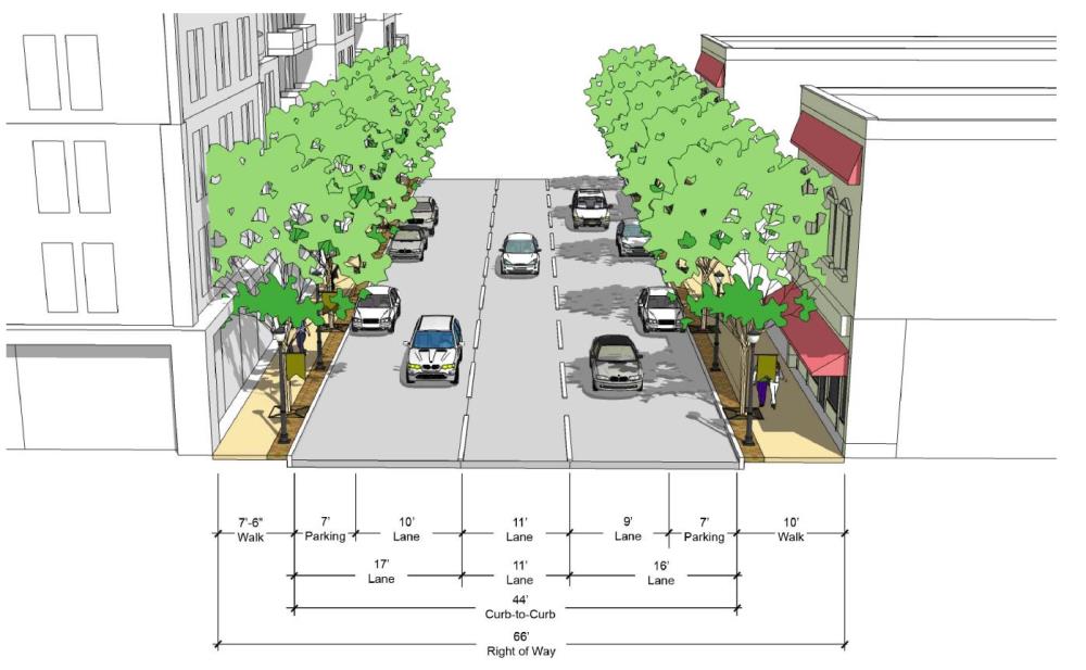

Current street cross-section.

Current street cross-section.

Section 2 of the corridor study introduces us to some Street Design Guidelines. You don’t have to be an urban planner to follow this section but a lot of the proposed changes to the corridor will follow these principles. Topics include:

  • Sidewalk Spatial Standards
  • Green Streets – Techniques to transform typical street surfaces into stormwater collection system using carefully selected landscaping.
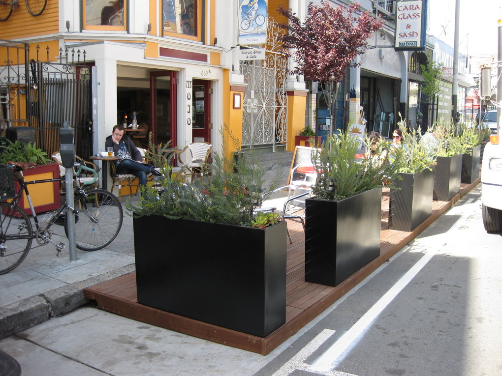
  • Bulb-outs
  • Street Furnishings
  • Components of a Vehicular Corridor
  • Components of a Intersection (including roundabouts)
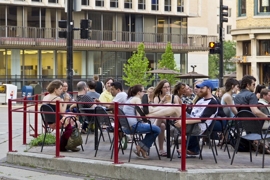
Outdoor cafe on bulb-out

Outdoor cafe on bulb-out by Kaizer Rangwala, on Flickr

The next section of the report gets into the details of transitioning from current conditions to both the one-way road diet and/or the two-way restoration.

With roundabouts around Capital Boulevard to the north and improved intersections around Hoke Street to the south, there are also conceptual drawings of what the new Blount/Person streets could look like running through downtown Raleigh.

During the One-Way Road Diet plan, the following would be implemented on Blount/Person:

  • “Maintains the one-way operation and proposes a ‘road diet’ eliminating one travel lane in each direction. The elimination of a travel lane allows the street to be reconfigured to include a bicycle lane in each direction (northbound on Person Street and southbound on Blount Street).”
  • “Bicycle Facilities – The corridor-wide road diet allows space for a continuous bike lane in each direction from Hoke Street to Atlantic Avenue.”
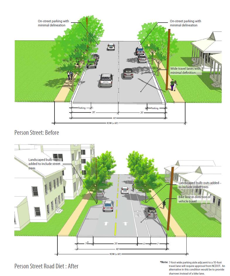
Before and after street cross-section.

Before and after street cross-section.

The Two-Way Restoration plan has a lot going on. Refer to section 3 of the report to see the conceptual designs that include a few more roundabouts as well as possibly slimming down Person and Blount Streets to one-lane in each direction. I do want to re-iterate that further analysis is needed to get to that point but this report starts the conversation.

The study wraps up with the traffic analysis. You can dive even deeper into that with the over 1000+ page detailed traffic analysis report for the real municipal geeks out there. The analysis shows how a variety of intersections currently perform and how they are projected to perform under the proposed changes.
Urban Design Center Survey For Next Downtown Raleigh Plan

I shared this on Twitter recently but wanted to drop it here since the deadline is this weekend. Raleigh’s Urban Design Center (UDC) is conducting a survey. The Downtown Perception survey asks you point blank what do you like about downtown Raleigh and what are ways to improve it. Click the link below to share your thoughts with the city.

2013 Downtown Perception Survey DRA/UDC

The UDC in collaboration with the Downtown Raleigh Alliance (DRA) will use the results towards the newest downtown Raleigh plan that should be taking place later this year.

Oh and I guess I can’t forget to mention that respondents who provide their email could also win a $200 downtown gift card. Get your answers in by June 16.

Weekend Reel: Economics of Downtown Development

I recommend email readers click through to the website to see the embedded video.

Here’s a great video that’s required watching for the connoisseur within. Raleigh’s Chief Planning and Development Officer, Mitchell Silver, gives a presentation about the return on investing in downtowns versus the suburbs.

I was at this presentation and thought it very informative. Enjoy!

Downtown Raleigh Lecture Videos For Erasing Any Holiday Boredom

Bored over the holidays? Here’s a video that should get all Downtown Raleigh fans excited. It’s part of the Urban Design Center’s education forums titled, “Raleigh’s Identity -What’s Downtown Got to Do With It?”

This is the first video of eight planned lectures. It’s very interesting to see the different downtown plans, with some going as far back as the 1950s.

Enjoy!

The Raleigh Comprehensive Pedestrian Plan, A Connoisseur’s Overview

Sidewalk along Peace Street.

The city’s newest plan for improving the pedestrian experience in Raleigh was posted on the city’s website a few weeks ago and public comments are being taken on it until this Friday. Whether you realize it or not, the sidewalks are a significant transportation system and are important for multi-modal trips around Raleigh.

Last year, voters approved a $40 million transportation bond with $4.75 million going towards sidewalk related improvements. The comprehensive plan lists out some of those projects as well as moving Raleigh to a new system of prioritization for future projects.

I found the plan thorough and easy to read. It goes into the design of new sidewalks and intersections, best practices, and uses technical language to explain things but not to a point that confuses a reader. This plan can really empower a neighborhood that’s looking to make changes and allow them to “speak the language” when researching the option to petition for improvements.

Here is my chapter to chapter summary for those preferring an even lighter read.

Continue reading →

Municipography: Union Station and R-Line Changes

Municipography is a summary of current issues going through the Raleigh City Council and other municipal departments in the city. The point is to try to deliver any video, photos, and text associated with the discussions happening at City Hall or elsewhere. Since this is a downtown Raleigh blog, the focus is on the center of the city.

I recommend email readers click through to the website to see the embedded video.

At the Raleigh City Council meeting on September 4, 2012, the council discussed funding for the Union Station project as well as approved some changes at the Moore Square Bus Station that will effect the R-Line.

Union Station

During the meeting, council discussed a future commitment of $3 million towards the Union Station project. Comments were generally positive about the station and it really feels that Raleigh and NCDOT want this project to succeed. With a 6-1 vote, the council approved the additional funds.

The city also approved the allocation of funds towards development of a schematic design for the project.

Bus Traffic at Moore Square Station

We haven’t talked about it on this blog before but there have been grumblings about the bus and pedestrian traffic along Wilmington Street and the effect it has on nearby businesses. To catch readers up, I’ll point you to a few articles from the local news media:

Business owners and residents in the Moore Square area met with the City of Raleigh on Tuesday, trying to come up with ways to address loitering, panhandling and bus congestion in the Moore Square District.

*Downtown Raleigh residents decry loitering, panhandling, ‘riff-raff’

Business owners say the crowds, coupled with bus congestion along the street, create an uninviting atmosphere for customers.

*New merchants chafe at crowds from Moore Square bus terminal

Here’s an alternative viewpoint from Barry Saunders at the N&O.

Here’s my advice to the business owners who are so dismayed that a city’s downtown transit center has people occupying various rungs of the social ladder: go out and meet them and talk to them. You may find that they are just like you, except they don’t have a car.

*Saunders: Respect needed among Moore Square’s old and new

Now that you are caught up, at the city council meeting this week, the recommendations from the Law and Public Safety Committee were unanimously approved. Those include:

  • Expand the bus zone on Wilmington Street to relieve bus congestion.
  • Move the R-16 Moore Square Deck station south of Martin Street.
  • The R-Line will now always run along the nighttime route that rounds Moore Square.
  • Immediate upgrades to the Moore Square Station including better pedestrian access, lighting, and safety upgrades.

While this may or may not solve the bus traffic issue on Wilmington Street, the R-Line may be the victim. R-Line riders could potentially experience added wait time as the bus will always make the trip around Moore Square rather than driving straight up Wilmington Street during the daytime operating hours. However, this may be a temporary solution until the Moore Square Bus Station is significantly upgraded for more bus capacity.

Some Additions To The Downtown Arena Discussion

A Carolina Hurricanes hockey game at the RBC Center in 2010.

We talked about parking earlier in the month and now it’s time for another love affair of mine; the downtown sports arena topic. I just want to quote two articles that add to the ongoing conversation. For newer readers, a sports arena in downtown Raleigh is an idea that floats in every now and then and is by no means planned or even in concept at this time.

You could certainly argue that I think we’re not ready for an urban arena and that the location of the PNC Center is perfectly adequate. To add some points on the development topic, whether arenas spur it or not, Richard Florida asks exactly that with an article at The Atlantic Cities.

Sports boosters claim the new stadiums bring economic benefits and add to a city’s “big league” status. But objective academic studies have countered this view, noting that stadiums add little in the way of actual economic benefit.

*Do Basketball Arenas Spur Economic Development?

The study that Mr. Florida writes about does mention cities that had a positive affect on development and a rise in regional income. However, it’s possible that this rise in an area’s income is a result from the arena moving from the suburbs to the city. The net could be zero.

And then comes the taxpayer benefit from making the investment in additional teams and stadiums/arenas. Dr. Kurt Rotthoff of Seton Hall University talked on the radio at WAMC about how politicians may try to sell the idea that sports teams and using incentives to build venues are a catalyst for economic development.

Hundreds of millions of dollars are spent on new stadiums, with the claim that they will create tens- or hundreds of millions of dollars of local economic impact; however, looking at county employment and incomes after a team enters or leaves a town, a co-author and I find mixed results on employment, with no overall impact, and mainly no impact on incomes, but a few cases of a negative impact. This means there is no impact, or possibly a negative impact, of bringing a team to town, and no impact, with the possibility of a positive impact, when the team leaves town. This primarily occurs because there is a shift in consumption, from restaurants and bars to the stadium, when these teams come to town and thus no net increase in consumption. Restaurants and bars do open closer to the stadium, but this is a result of them closing locations in other sections of town.

*Dr. Kurt Rotthoff, Seton Hall University – Economic Impact of Sports Arenas

One can just look at West Raleigh and see that development has not followed the PNC Center and it’ll be years before it does. Mr. Florida ends his article well with:

The present research is generally consistent with the notion that professional sports are not the cause of development so much as they are the effect.”

West Raleigh fans do have a lot to look forward to in the Blue Ridge Road District Study which may turn that street and all the areas around the fairgrounds and the sports complex into an active destination.