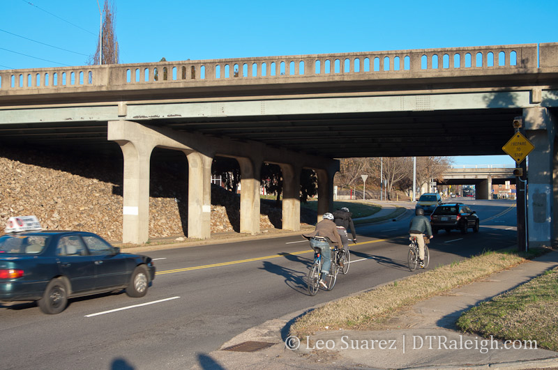
Cyclists ride under the Capital Boulevard bridge at Peace Street
Last night, NCDOT were showing off proposed design alternatives of the upcoming bridge replacements for Capital Boulevard at Peace Street and Wade Avenue. This is an upcoming project that comes out of the need to replace these approximately 50-year-old bridges before they become functionally unsafe. There are plans for two different alternatives for each bridge and I wanted to go over the bridge designs at the Capital and Peace intersection.
The two alternatives are being referred to as Alternative P-Base and Alternative P5. In my opinion, you have the status quo in the P-Base alternative and a new design in P5. However, as is to be expected the P-Base plan is the cheaper of the two. Let’s get in to each before comparing the two against each other.
Alternative P-Base

Alternative P-Base for the new Capital Boulevard bridge over Peace Street. Click for larger.
Like I stated earlier, the P-Base plan seems to have the least impact to the area and delivers a new bridge with the same street design around it. Entering and exiting Capital Boulevard from Peace Street is almost the same as today.
There are a few enhancements here that will help vehicles turn. The northbound entrance ramp to Capital from Peace would be two lanes wide, the right-most lane being a turn lane for the Cotton Mill parking lot. Also, when exiting downtown on Capital heading north, a right-most fourth lane will pop-out and feed the exit onto Peace Street. The same principals are there for exits and entrances on southbound Capital, where a fourth lane exists for merging compared to the abrupt turn lane that’s there now.
It also looks like the entrance to the small row of shops (Jersey Mike’s, Dry Clean City, etc.) will not have that little driveway onto the northbound Capital ramp.
Alternative P5

Alternative P5 for the new Capital Boulevard bridge over Peace Street. Click for larger.
P5 has a lot more going on around the same new bridge that will be built. Capital Boulevard entrances and exits have been moved and will result in a new traffic pattern. Before we go over these, it’s important to show the new street connections that are proposed.
Harrington Street would play a much bigger role in the P5 plan. Here, Harrington would kind of “punch” through and connect to Peace Street, accomplished through the use of property acquisition. This would create a brand new, signalized intersection.
Nearby along southbound Capital, the parallel service street, intersecting Johnson Street to the north, would be redone as well. Rather than an awkward turn off Capital, you could now make a right turn, with a dedicated turn lane, onto a connecting Johnson Street. This then drops you off at Johnson and Harrington and off into Glenwood South.
Along northbound Capital, new to any proposed design yet, is a longer off-ramp with driveways to Johnson Street to the south of Peace and a turn lane to the Cotton Mill on the north. This off-ramp will create another signalized intersection at Peace Street.
So with these additions, there are some things that are removed. Gone are the “cloverleaf” style on/off ramps at Capital on to Peace. With the addition of the Johnson Street connection and Harrington Street extension, traffic should flow through here in its place.
Matching Them Up
The two plans don’t share much but walkers and cyclists get a win with both. Peace Street will get 5-foot bike lanes and what looks like wider sidewalks, which are desperately needed as nature is reclaiming the current pedestrian paths on the south side.
A minor detail that I thought was important is that both plans call for 11-foot lanes on Capital Boulevard. This actually contradicts the Capital Boulevard Corridor Study’s “Happy Motoring” section stating that 12-foot lanes were something to work towards. I believe that increasing those lane widths would have created faster speeds, more vehicles, and more traffic along Peace Street. I commented in support of the 11-foot lanes for either plan as it compliments an urban area better.
Cost of the two plans is drastically different. According to last night’s handout:
- P-Base – $26.4 Million
- P5 – $37.4 Million
That’s an $11 million dollar difference. The bulk of the reason comes from the property acquisition involved in each alternative, 5 versus 12 properties in the area.
Overall, I left comments in support of the P5 alternative. Simply put, this area is pretty much a place to get through and not stop in. We already know that delivering the same thing will most likely produce little new results so we almost owe it ourselves to find that $11 million and try something new.
I feel the P5 alternative slows traffic down and starts to transition the area towards one with better urban form. I’m a huge fan of a grid-like street network and this alternative creates that in the new connection at Johnson Street and the Harrington Street extension. If we can add in on-street parking along these areas, interest in new development could increase. It can’t get any lower as the area only consists of sprawl-like, one-story buildings with surface parking.
NCDOT is taking input on the alternatives over the next few weeks. Here’s the project page on the NCDOT website with contact information so you can submit your thoughts.
The handout also gave us a project timeline.
- Winter 2013 – Environmental Assessment
- Spring 2014 – Public Hearing
- Fall 2014 – Final Environmental Document
- Fiscal Year 2015* – Begin Right of Way Acquisition
- Fiscal Year 2016* – Begin Construction
[UPDATE: 11-21-13]
I’ve added the cross section of Peace Street which shows the 5-foot bike lanes on each side of the street. The cross section is pretty much the same between the two alternatives. Click for a larger view.

Comments
Comments are disabled here. That's because we're all hanging out on the DTRaleigh Community, an online forum for passionate fans of the Oak City.
Crazy! A typical cloverleaf would work best and seem safer. Those old building just need to go!
Thanks for the update Leo and I agree with you that P5 is MUCH better for the entire area. In particular, the P-Base proposal all but cuts off Peace Street access to the parcel that currently houses the city’s garbage trucks. Additionally, P5 seems clearly more friendly to the residents of the Cotton Mill and gives the city an opportunity to put in a small park on the corner where the current ramps exit. Lastly, I agree that P5 better opens up the SW corner of the Peace/Capital intersection to urban development.
I am very happy to hear that the 12′ lanes seem to have been abandoned. That’s a huge win for the area and for DT.
Perhaps getting citizens behind P5 is something that can be done through the LinkPeace website? Last I checked, it was still operational.
The current onramps/offramps around Capital are absolutely horrible. They’re unsafe, severely outdated, and unintuitive. If this is our chance to redesign them we should do it.
Both plans rebuilt large sections around the highway and improve the onramps.
P5 seems to improve all the connections around the highway much more. I’m inclined to favor it, though I’m not sure how much better it actually would be in practice.
I’m not seeing bike lanes in those designs. Am I missing something?
I also prefer P5.
Mike, they aren’t shown on the maps unfortunately but in another section of the map there is a street cross section showing 5-foot bike lanes next to 11-foot vehicle lanes.
I’ll extract it from the pdf and update this post. I think that’s important to show. Thanks.
I agree that P5 is the better of the two options given.
It’s unfortunate that we cannot simply remove the bridge to create an at-grade 4-way intersection. This would fully remove the “freeway” like design and slow traffic the most, as well as encouraging a truly walkable urban format along the lenght of Peace St.
That may be an engineering impossibility, but a guy can dream right?
David, I’m not sure if you were aware of it but I was part of a team in early 2012 where we worked with the state and city to get an at-grade intersection option on the table. Our initiative was called Link Peace Street. Our website is still up now, http://linkpeacestreet.com/
Sadly, the idea resulted in an intersection that failed all the traffic models. I could go on and on about it but I’ll leave it at that for now.
I’d like to see them extend the bridge to span over Finch’s. Other cities have bridges that span over buildings when needed. I know its an added cost, but if we base all of our decisions on cost then we will be left with a bland city.
I just submitted comments to NCDOT supporting P5.
I think it creates a grid of streets with smaller blocks and more connections. I agree with your thinking on how this will help characterize this area as more urban and not somewhere you speed past. This will improve the overall gateway feel into downtown.
Leo: In the end, I don’t think that our efforts in 2012 were for naught. Clearly the P5 proposal addresses issues at the intersection better than previous versions did. We may not have moved the needle all the way to where we wanted it go but I have to believe that we did make an impact. I really think that the LinkPeace website would be an excellent resource again to push for P5.
Already we have narrower lanes! That’s a huge improvement that will help keep speeds from getting out of hand.
Can we have the extension of Harrington from P5 but still keep the southbound offramp directly from Capital to Peace? (We don’t need the cloverleaf onramp from Peace to southbound Capital.)
I like P5 a lot – it reminds me of a scaled-down version of the Glenwood Ave & Lumley/Westgate intersection near 540, which I’ll grant is slightly weird the first time you drive through it, but does seem to work well for all of the driveways from Glenwood at that spot.
I am also a fan of P5. I also agree we don’t need an onramp from Peace to Dawson St. two blocks away.
If I HAD to choose between P5 and P-Base, P5 is superior and worth more expense than P-Base. But they are both regressive and foolish choices. Put me on record as begging the powers-that-be to re-consider.
Dave said it clearly on his post on 11-22-2013: “simply remove the bridge to create an at-grade 4-way intersection. This would fully remove the “freeway” like design and slow traffic the most, as well as encouraging a truly walkable urban format along the length of Peace St.”
And Leo, I commend you and your team for the enlightened 2012 effort to sell engineers on an at-grade intersection option. It is no surprise that it “failed all the traffic models”. That is double-talk for “we care more about cars and this wouldn’t carry the car volume we’d like to see”.
Anything less than an at-grade intersection fails my own test for walkability, human ambience, and city grid expansion options.
The same catastrophic mistake lies at the south end of downtown, where Western Boulevard bridges over Dawson, ending walkability and grid expansion to the south.
It is no accident that downtown Raleigh is expanding organically and pleasingly to the east and west, but not to the north and south.
There is no intelligent reason to arbitrarily terminate downtown walkability and ambience at those bridges on the north and south end of downtown. I am sure that any contemporary urban designer would agree.
Simply put, bridges are for rivers and canyons, and should always be a last resort in urban intersection design. (Cue crowds, microphones, and voice of Ronald Reagan)…”Traffic engineers, TEAR DOWN THOSE BRIDGES!”
Renpark John,
I couldn’t agree with you more! Clearly the city’s vision to expand the DT core up Capital Boulevard to Wade Ave is significantly damaged by the mini-freeway nature of Capital Blvd coming out of DT. This is why a group of us pushed for consideration of an at grade intersection in 2012. Well, without the political influence and even without the support of the lone City Council member who LIVES in the Cotton Mill, we were not successful in willing it to happen. ;-(
It’s very sad indeed.
That said, there is at least one small win that Leo points out and that’s the reduction of the lane widths on the proposed bridge and roadway from 12 feet to 11 feet. Back when the bridge proposals first came to my attention, I wrote a letter addressing that issue among others as being in direct opposition to the city’s plan to expand DT northward. LIke your comments, I also mentioned how the Western/MLK overpass essentially kills the southern extension of DT. Lowering posted speed limits in that corridor are another mechanism that we can push to give the north end of DT the best opportunity to expand.
so, like you, I would choose P5 if I must choose between the two and it appears that that is really our only choices right now without significant political power. Now, given that a bridge is a foregone conclusion, what are the other things that we can do to ensure that this short stretch of Capital be constructed in the most urban affirming manner possible? In addition to the narrowed lanes and lowered speed limits, maybe we can push or an at grade intersection somewhere between Peace and Wade to slow traffic further with a traffic light? Maybe we should be thinking about the overall width of the right of way from east side to west side of the road? Maybe we should be look for best practices from other cities that have a similar issue?
Oh, as for Reagan, I can’t imagine that he’d be on our side in this issue. wink
An interchange at Peace & Capital can be designed to be fairly pedestrian friendly. The current interchange at least has a compact design; here we have a chance to make it better. The P5 alternative definitely does that. In fact the P5 alternative wastes basically no land on landscaped medians. It even looks like they’re even planning for a realignment of W. Johnson so it can connect through into Glenwood South. Basically this is a great design.
Please – do whatever traffic calming you want on any other street downtown. But I would think twice about the consequences before doing this to the Capital-Dawson/McDowell-Saunders axis. Remember that these roads were set up the way that they are, in order to avoid the need for a six-lane FREEWAY between East and Bloodworth. This is not the place for traffic calming. We are not a city with world class transit and 100,000 people living downtown. The vast majority of people still live elsewhere and get downtown by car – and this is the road that they use to do so.
I agree that the Western/MLK/Dawson/McDowell interchange is horrendous. It takes up about four times as much land as the Peace/Capital interchange, and has absolutely zero accommodations for pedestrians. It definitely needs to be redesigned. But not turned into an at-grade intersection.
P5 does not show W. Johnson aligned with the portion through Glenwood South.
Also, (and I’m now in favor of a compact/urban grade-separated interchange) but it seems weird to me that the traffic counts are so drastically different that an at-grade intersection works perfectly fine .3 miles to the South, but at Peace St it’s completely out of the question.
I think the difference between this and the intersection furhter south at Lane Street, is that from Lane street south, Capital Blvd turns into the Dawson/McDowell one-way pair. One way pairs allow perfect synchronization of signals. Plus, the traffic on Peace is a lot heavier than Lane.
Regarding the Johnson Street connector. Of course this is all conjecture and I have no idea what’s really going on. But the part of Johnson Street that connects to Capital Blvd would definitely get shifted to the north, and there’s no reason I can think of for that other than to allow an eventual connection with the other section of Johnson Street further to the west.
https://mapsengine.google.com/map/viewer?mid=zDxDEf2QTUKg.kdQUj0cowfKU
If this does happen, it probably wouldn’t happen immediately as part of the interchange reconstruction, but rather if and when the Southland Ballroom/Wood Products INC building is redeveloped. To balance it out the city could swap the land from the Harrington Street dogleg for the land to build the Johnson Street connection. In the end, the property owner would come out approximately even as far as acreage is concerned.
Yes, like Orulz said, the McDowell/Dawson one-way pair is a different thing to work with compared to the two-way Peace/Capital intersection.
The problem during the at-grade intersection traffic models performed last year, from my point of view anyway, were that left/right turns were added to the models. So instead of two cycles; an all red light and all green light, like Dawson/McDowell, at-grade Peace/Capital was modeled similar to a suburban intersection that also had a third light; a left-turn cycle which slowed things down and created a lot of congestion. (according to the models anyway)
I compared it to Western/Avent Ferry or Capital/Spring Forest (numerous other examples) where one or even two left turn lanes exist. (and in some cases a dedicated right-turn) The team couldn’t organize a strong enough counter argument since this idea was seen as radical and the city’s attitude was more of “a bridge isn’t that bad.”
I still wonder to this day what could have been if Peace/Capital could be at-grade without left turns and in combination with most of the concepts in the old “Square loop” and now in this P5 plan.
It was proven, by the city, that:
1. Northbound Capital to Peace was so low it could be removed completely.
2. Peace to southbound Capital was so low it could be removed completely.
The biggest point of contention in the discussion was the southbound capital left turn onto Peace, basically the state govt employees’ route coming into town.
However, if P5 is chosen, the planners acknowledge that the state govt traffic is acceptable to route via Johnson, Harrington, Peace. (under the bridge) An at-grade intersection would add a light for these folks at Peace/Capital twice. (once on the way in, second along Peace)
But then what if access to the state govt complex was improved with a two-way conversion of Lane? These, along with other big ideas for the Salisbury/Wilmington pair within the govt district were never discussed as the planning took a micro-focus on the immediate area rather than a larger network.
An at grade intersection is also not desirable because you would be left with a massive intersecion at least 7 lanes wide (and perhaps as many as 11?) that you have to cross when walking down Peace Street.
This isn’t San Francisco where there is world class transit and a grid system yielding dozens of alternate routes. This is Raleigh where there is little transit and there are only three routes into downtown from the north. Capital is by far the busiest of the three; the alternatives (Glenwood and Wake Forest-Blount/Person) are much smaller and also cut through neighborhoods.
I for one would rather keep as much traffic on Capital as possible and in exchange do things like two-way conversions on Blount and Person.
If you want to talk about connecting Wade to Halifax providing a fourth route into downtown, then we can talk about an at grade intersection for Peace and Capital.. But Peace College, Pilot Mill, and Capitol Park would be sure to kill that one.
[…] This is the catch: An alternative bridge design can be done with much less cost ($11 million) as it is basically a copy of the bridge today. The details on the two options are laid out nicely on the Raleigh Connoisseur blog. […]
[…] *New Capital Boulevard Designs Out, Status Quo versus New Connections […]