Union Station Concepts Shown To Future Raleigh Train Riders

Last night, Raleighites had a chance to hear a presentation about the upcoming Union Station and to comment on some of the high level concepts being drawn up for the new station. This was the first of several meetings to show off the work as it progresses towards a more complete design.

I want to reiterate the fact that this meeting was indeed very high level and nothing concrete has been put into plan. The presenters spent about 30-45 minutes going through slides of the warehouse district and the viaduct building itself. Maps showed very rough concepts that the station will have, things like a mix of gathering space, retail, and operations space.

The presenters emphasized that they wanted the entrance to be grand and inviting. Borrowing from a plethora of examples from around the world, it felt like Raleigh’s Union Station will try to have that big and open-style entrance that others seem to have.

The very first concepts, the ones that have been out way before this meeting, of the station layout are actually being challenged. More emphasis on the gathering space, making it bigger and more voluminous, was shown in the drawings. There also was, what appeared to be, more thought put into the parking lot layout than before.

Here’s the original layout of the station area.

Raleigh Union Station Original Layout

Notice the parking lot layout relative to West Street.

And now here is the original floor plan for the interior.

Raleigh Union Station Original Layout

Here you can see the breakdown between the gathering space, shown in blue, the retail space, orange, and the office space, brown.

Last night, we had this new plan on the table.

Raleigh Union Station new layout

The same blue area in the image above shows an elongated gathering space that goes from the front to almost the back of the building. This comes from a different layout of the offices and incorporating some of the upper floors of the northern part of the building. The larger gathering space, suggested to be lit up with lots of natural light, is a great idea and I hope the planners can deliver it.

The parking lot has been rethought with a second entrance to West Street and a traffic circle in front to keep vehicles moving and avoiding conflict with parking. This is definitely a step in the right direction as car/bus traffic flow is being thought of in a smarter way.

I’m hoping the entrance in the front, with a pedestrian plaza, will really get some extra attention. As soon as travelers arrive at Union Station, they will be stepping into downtown and the plaza needs to make a statement. I’m hoping visitors will stop for a quick second and feel like taking a photo of themselves.

Great stuff so far. Expect more details during the next presentation.

Raleigh Union Station Public Workshop, March 6

The first of a few public information sessions about Raleigh’s train station upgrade, Union station, is coming up. On March 6, come down to the session to see renderings and plans for the new station in the warehouse district. Citizens will be given the opportunity to comment and give feedback towards the future design steps.

The workshop will also go over the West Street extension, a project that proposes to extend West Street to the south to West Cabarrus Street. This extension is a major compliment to Union Station and the greenway system.

Union Station will be Raleigh’s new train station at West and Martin Street. The project will be a complete renovation of the Dillon Supply Company Warehouse. See previous posts on the topic for background information.

Raleigh Union Station Public Workshop

Date/Time: Wed., March 6 from 6 p.m. to 8 p.m.
Meymandi Concert Hall Lobby
2 East South Street
Raleigh, NC 27601
919-996-8700

Raleigh Union Station Public Workshop

Union Station Fully Funded, Could Be Open In 2016

Raleigh Union Station interior before renovation

This is a short one but a good one. Some great news out of the future Raleigh Union Station last week.

Mayor Nancy McFarlane welcomed Federal Railroad Administrator Joseph Szabo to Raleigh today for the announcement that the Union Station Project will receive the full $60 million in funding.

*Full Funding for Raleigh’s Union Station Project Is Announced

The video of the announcement can be seen below or on Youtube.

Municipography: Union Station and R-Line Changes

Municipography is a summary of current issues going through the Raleigh City Council and other municipal departments in the city. The point is to try to deliver any video, photos, and text associated with the discussions happening at City Hall or elsewhere. Since this is a downtown Raleigh blog, the focus is on the center of the city.

I recommend email readers click through to the website to see the embedded video.

At the Raleigh City Council meeting on September 4, 2012, the council discussed funding for the Union Station project as well as approved some changes at the Moore Square Bus Station that will effect the R-Line.

Union Station

During the meeting, council discussed a future commitment of $3 million towards the Union Station project. Comments were generally positive about the station and it really feels that Raleigh and NCDOT want this project to succeed. With a 6-1 vote, the council approved the additional funds.

The city also approved the allocation of funds towards development of a schematic design for the project.

Bus Traffic at Moore Square Station

We haven’t talked about it on this blog before but there have been grumblings about the bus and pedestrian traffic along Wilmington Street and the effect it has on nearby businesses. To catch readers up, I’ll point you to a few articles from the local news media:

Business owners and residents in the Moore Square area met with the City of Raleigh on Tuesday, trying to come up with ways to address loitering, panhandling and bus congestion in the Moore Square District.

*Downtown Raleigh residents decry loitering, panhandling, ‘riff-raff’

Business owners say the crowds, coupled with bus congestion along the street, create an uninviting atmosphere for customers.

*New merchants chafe at crowds from Moore Square bus terminal

Here’s an alternative viewpoint from Barry Saunders at the N&O.

Here’s my advice to the business owners who are so dismayed that a city’s downtown transit center has people occupying various rungs of the social ladder: go out and meet them and talk to them. You may find that they are just like you, except they don’t have a car.

*Saunders: Respect needed among Moore Square’s old and new

Now that you are caught up, at the city council meeting this week, the recommendations from the Law and Public Safety Committee were unanimously approved. Those include:

  • Expand the bus zone on Wilmington Street to relieve bus congestion.
  • Move the R-16 Moore Square Deck station south of Martin Street.
  • The R-Line will now always run along the nighttime route that rounds Moore Square.
  • Immediate upgrades to the Moore Square Station including better pedestrian access, lighting, and safety upgrades.

While this may or may not solve the bus traffic issue on Wilmington Street, the R-Line may be the victim. R-Line riders could potentially experience added wait time as the bus will always make the trip around Moore Square rather than driving straight up Wilmington Street during the daytime operating hours. However, this may be a temporary solution until the Moore Square Bus Station is significantly upgraded for more bus capacity.

Municipography, Walking, Union Station, and Commuter Trains

Municipography is a summary of current issues going through the Raleigh City Council and other municipal departments in the city. The point is to try to deliver any video, photos, and text associated with the discussions happening at City Hall or elsewhere. Since this is a downtown Raleigh blog, the focus is on the center of the city.

Walk Raleigh

Matt Tomasulo and his Walk Raleigh signs have been accepted as a gift to the city. The signs brought international attention to Raleigh and after some time had to be taken down because of the lack of a permit. Still, the signs made their statement and some will be put back up for a 90 day pilot program.

The council unanimously approved.

Union Station Financials

Last month, city staff was authorized to apply for a Transportation Investment Generating Economic
Recovery (“TIGER”) grant for a component of Union Station. The NCDOT and Triangle Transit are helping with the application too and have come up with this financial breakdown:

  • Station development: 80% federal, 10% state, 10% city
  • Rail/track/platform improvements: 80% federal, 20% state
  • Street improvements: 80% federal, 20% city

This puts the city’s cost at $7 million. Remember, that last year $3 million was approved by voters in the Transportation Bond. So the remaining $4 million will have to be worked into next year’s budget cycle. This move helps the grant application.

John Odom voted against this stating concerns about the cost while the rest of the council approved.

Commuter Rail Station Locations

The city’s Passenger Rail Task Force stopped by to endorse the locations of the commuter rail stations in Raleigh. Those four being at:

  • Southeast Raleigh at Hammond and Rush Streets
  • Downtown Raleigh at the Warehouse District
  • NC State near Dan Allen Drive
  • West Raleigh near Corporate Center Drive

You can read about more about this as well as light rail and buses at the Transit tag link but for the best wrap up of the commuter rail plans jump to, “Transit, Commuter Rail, and More, We Dive Into The Docs.”

The council approved this unanimously.

Municipography, Union Station and Downtown Property Loans

Municipography is a summary of current issues going through the Raleigh City Council and other municipal departments in the city. The point is to try to deliver any video, photos, and text associated with the discussions happening at City Hall or elsewhere. Since this is a downtown Raleigh blog, the focus is on the center of the city.

The first Raleigh City Council meeting of 2012 was held yesterday. The proposed Union Station was discussed and the agenda describes it just as well as I can. From the January 3, 2012 agenda packet:

F. REPORT AND RECOMMENDATION OF THE PASSENGER RAIL TASK FORCE

1. NCDOT Concept for Raleigh Rail Station

At their December 12, 2011 meeting, the Passenger Rail Task Force discussed proposed improvements to the Dillon Viaduct Building by NCDOT to convert the facility to a passenger rail station. The new station would replace the existing train station on West Cabarrus Street and would accommodate existing Amtrak service, proposed future high-speed rail service, and the proposed future Triangle Transit commuter rail service. The passenger rail station would be the first phase of a larger Union Station multimodal facility that would also provide service to local bus, regional bus, and light rail services. City staff will continue to work on conceptual designs for future phases of the Union Station multimodal facility.

After reviewing draft concept plans presented by the NCDOT Rail Division, the Task Force voted unanimously to recommend endorsing the proposed Viaduct Building rail station retrofit concept. A complete copy of their evaluation is included in the agenda packet. $3 million has been appropriated for City participation in the cost of this facility
as part of the 2011 Transportation Bond and will be available in FY13 in the draft Capital Improvement Program.

Recommendation: Endorse the findings of the Passenger Rail Task Force to retrofit the
Dillon Viaduct Building for use as the rail station of Union Station.

The council voted unanimously to endorse this site and the plans recommended by the Passenger Rail Task Force. Watch the video below for more discussion about it during the meeting.

A great pdf document that goes over the concept of turning the Dillon Viaduct building into a train station is “NCDOT Viaduct Building Assessment”, taken from the Passenger Rail Task Force webpage on the city’s website. You can download it here. In this document, you can see the phased approach to adding new platforms for Amtrak, commuter rail, and high-speed rail to the Boylan Wye as well as other additions to accommodate the station.

Downtown Loan Program

The Downtown Loan Program was created for properties along Fayetteville Street, typically older structures, to be brought up to proper code for owners and potential tenants. This was an effort to help bring businesses to the Fayetteville Street area after it’s renovation a few years ago. The loan program is now being expanded to more streets in downtown Raleigh. From the City of Raleigh’s press release, the streets include:

The program will include portions of Dawson Street, Glenwood Avenue, Hargett Street, Martin Street, Davie Street, Fayetteville Street, Blount Street, Person Street and designated at primary retail Street in the Comprehensive Plan. Designated secondary retail streets include portions of Harrington Street, West Street, McDowell Street, Dawson Street, Salisbury Street, Wilmington Street, West Morgan Street, Hillsborough Street and Peace Street.

And finally more about the program:

The program is designed to create an incentive to new and/or expanding Downtown businesses and commercial property owners seeking to improve properties. To be eligible for the loan program commercial property owners and business owners must demonstrate management ability and experience. Qualified applicants must show they are unable to secure financing from financial institutions for the amount being requested from this program. To date the program has made three loans to area businesses. One of the loans has been fully repaid. Currently $200,000 is available.

The expansion was approved by the council during the consent agenda.

Transit, Commuter Rail, and More, We Dive Into The Docs

Tomorrow is an interesting day for transit fans as Durham County steps up to tax themselves in order to bring upgrades to our region’s transit. A one-half cent sales tax increase will be on the ballot in order to make these things happen. Readers should pay close attention because Raleigh’s close buddy may be bringing some goods to this symbiotic metropolitan partnership.

The informative website Our Transit Future (OTF) has documents aplenty to read up on but in case you haven’t gone through them, I’d like to attempt to summarize some of the things that may benefit Downtown Raleigh in the near future if Durham voters approve the tax increase. The documents there describe future stations, timetables, expected ridership, and other facts that could come into reality in the Triangle within the next decade.

Clearly, this blog supports the upgrade of transit in the Triangle and I hope that this tax is passed in Durham County. Let’s see what aspects of the plan may have an impact on downtown.

Durham’s Plan Links To Raleigh

The Durham County transit plan will go towards the following Raleigh related improvements, according to the fact sheets listed on the OTF site:

Step 2 – Rail from Durham to RTP and Raleigh

  • 2012 – Initial planning and engineering begins
  • 2018 – Opening year of peak hour rail connection to RTP and Raleigh
    – Length of corridor: 37 mi.
    – End to end travel time: 51 min.
    – 4 stations in Durham county
  • Later Saturday and Sunday connectivity between Downtown Durham and Downtown Chapel Hill; between Downtown Durham, RTP, and Raleigh; and, between Chapel Hill, southern Durham, RTP, and Raleigh.
  • More frequent express trips between Durham and Raleigh.

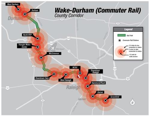
Here’s a map of the commuter rail line planned for the Triangle going from West Durham to Greenfield Parkway, Garner.


Click for larger

There are some explanations as to why commuter rail is being planned from Raleigh to Durham while light rail is being planned from Durham to Chapel Hill.

Why is light rail the technology for the Durham to Chapel Hill rail line and commuter rail the technology for the Durham to RTP and Raleigh rail line?

The different technology choices for the Durham to Chapel Hill and Durham to RTP and Raleigh rail systems were chosen to best respond to the characteristics of the travel markets in each corridor.

Durham to Chapel Hill Light Rail: This 17-mile corridor already has high traffic, a demand for transit and features three travel markets that include all-day trips and many short trips:

  • Work and student trips to Duke University/Hospital and Downtown Durham from the west
  • Work and student trips to UNC-Chapel Hill/Hospital from the east
  • Low-income work and shopping trips from East Durham to retail districts along 15-501

Additionally, the corridor features significant special event attractions such as DPAC, Brightleaf Square, Ninth Street, and UNC Dean Dome. Some of the most-densely populated census tracts in the Triangle including UNC’s main campus and Duke’s east campus are within a short walk to rail stations. This rail corridor is also well-positioned to capture the already-existing 3,000 to 4,000 daily bus transit riders from points east traveling to UNC via park and ride and Triangle Transit services such as bus 805 in Woodcroft in South Durham.

Durham to RTP and Raleigh: This 37-mile corridor features multiple travel markets with long trip lengths:

  • Work and student trips to NCSU/Downtown Raleigh
  • Work trips to Duke Medical Center
  • Work trips to Research Triangle Park

The corridor features considerable work trips but comparatively less non-work trips than the Durham-Chapel Hill corridor. There is existing heavy transit demand for NCSU, and considerable transit demand for employment trips to downtown Raleigh. These long transit trips remove large amounts of vehicle miles traveled from regional highways, and
the higher average speed of commuter rail over great distances makes it the ideal technology to attract motorists out of their cars with speeds that will most likely be unachievable by car during rush hour in the future.

The documents also predict a daily ridership of 7,000 boardings per day between Raleigh and Durham.

Corridor Studies, The Gritty Details

Outside of the documents that revolve around the tax increase and transit investment plan are others that focus on the three transit corridors with much more details. (up to date as of July 2011) Those three are:

  • Durham-Orange Corridor
  • Durham-Wake Corridor
  • Wake Corridor

While the Wake Corridor information impacts downtown Raleigh more, tomorrow’s vote in Durham will most likely help some of the plans documented at the Durham-Wake Corridor link more. Having said that, I’ll focus only on the documents at that link and save the Wake Corridor for another time. (maybe when Wake votes for transit improvements next year?)

Commuter Rail

  • The commuter rail line between Durham and Garner will run in the North Carolina Railroad Corridor.
  • NCDOT will double track certain section in order to separate other rail traffic. (freight and high-speed)
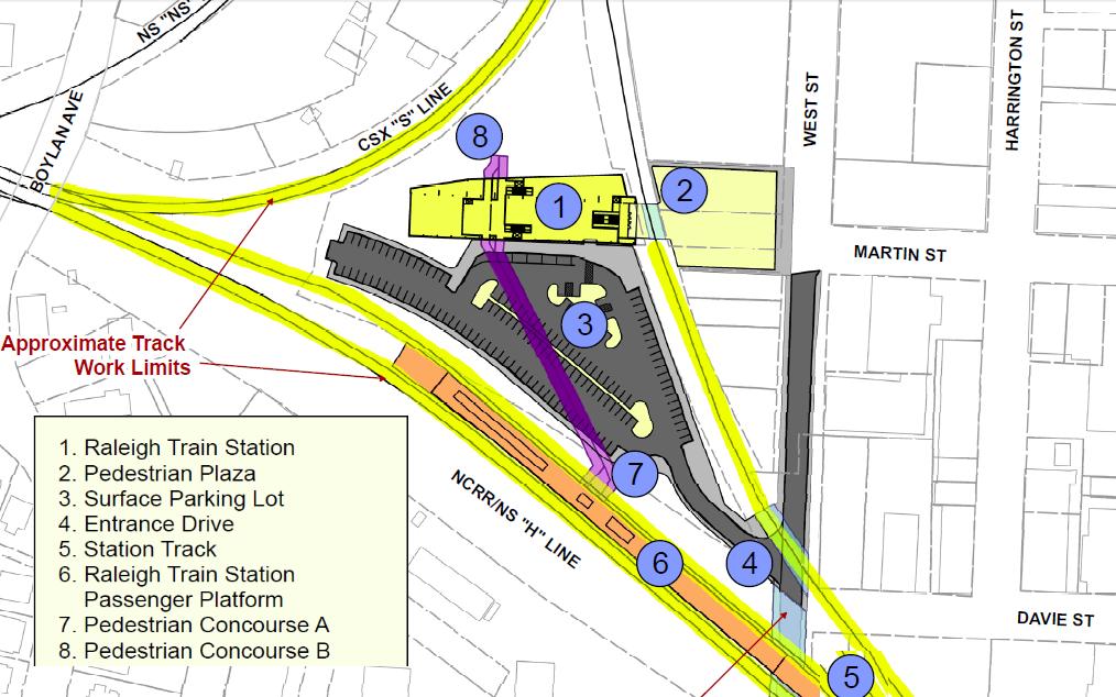
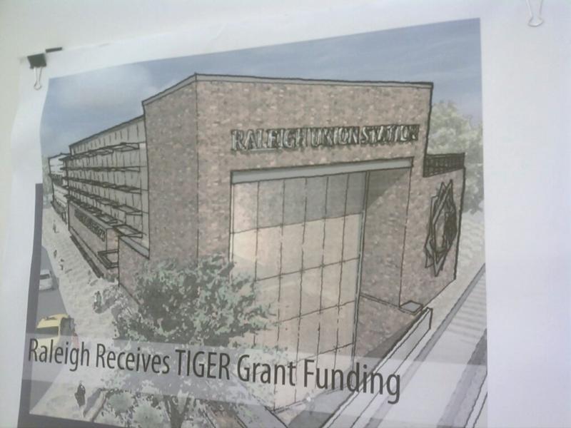
  • Proposed Downtown Raleigh station location:
    – Location in existing railroad right-of-way neat the intersection of West and Davie Streets.
    – Station would have walk-up features, at-grade, side platform and pedestrian access to future Union Station.

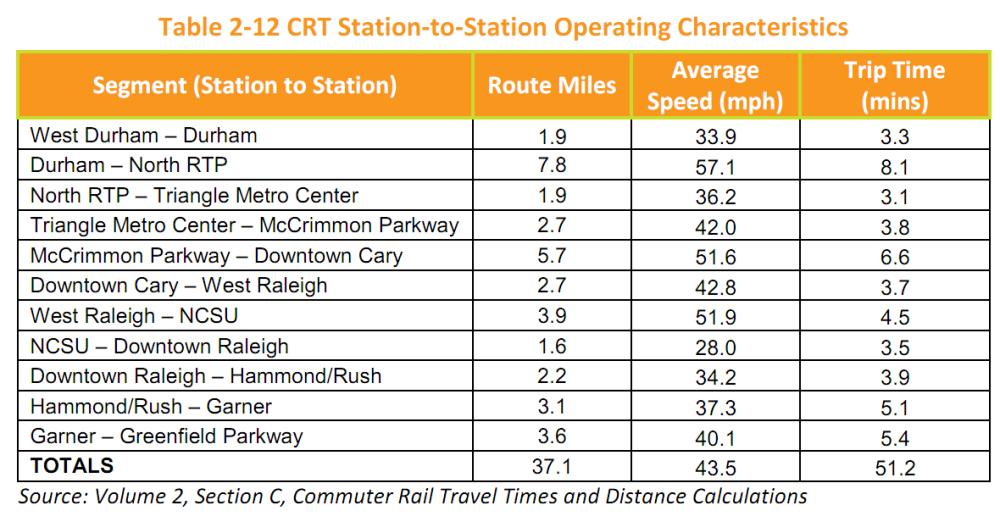
This table shows the Commuter Rail Station-to-Station Operating Characteristics.
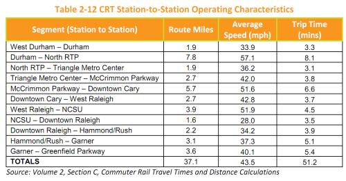

Click for Larger

This table breaks down the 51 minute end-to-end trip time so with it we can predict how long it will take to get to and from popular locations.

  • Downtown Raleigh and Downtown Cary: 11.7 minutes
  • Downtown Raleigh and North RTP: 25.2 minutes
  • Downtown Raleigh and Downtown Durham: 33.3 minutes

FYI, the North RTP station is approximately located near the intersection of Miami Boulevard and Cornwallis Road.

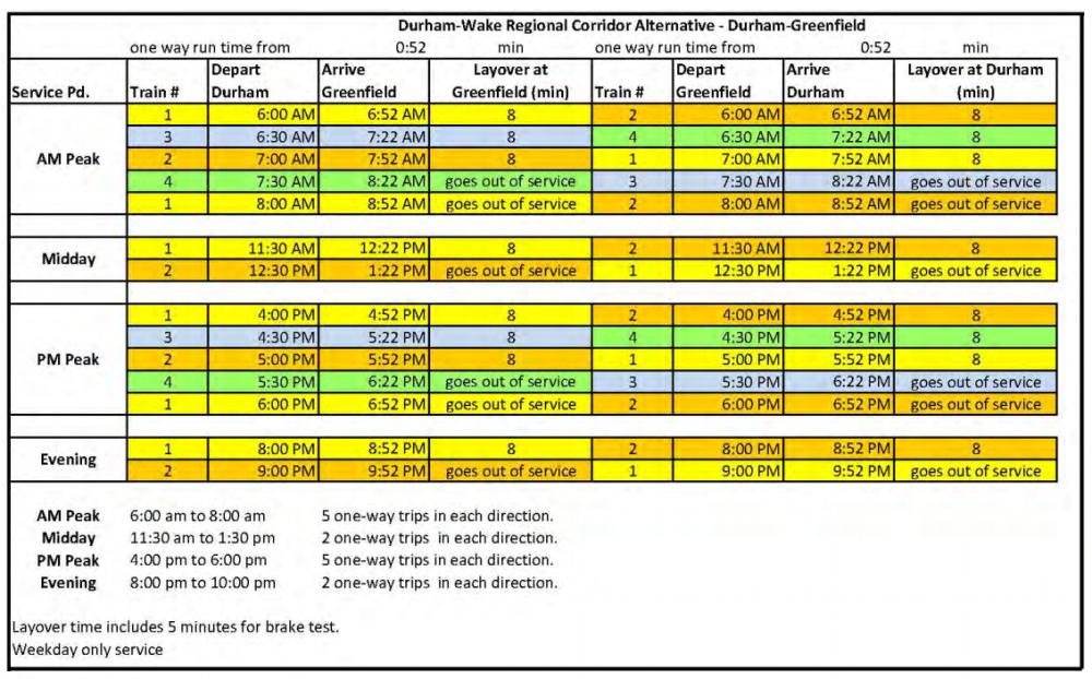
While weekend service is not planned, weekday service hours of commuter rail could look like what is described in this table.
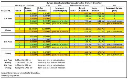

Click for larger

If you are a map person and would like to view each and every section of the commuter rail line from end-to-end, jump into this 14 MB pdf here. There are also more detailed topography maps available for the entire line at the corridor link.

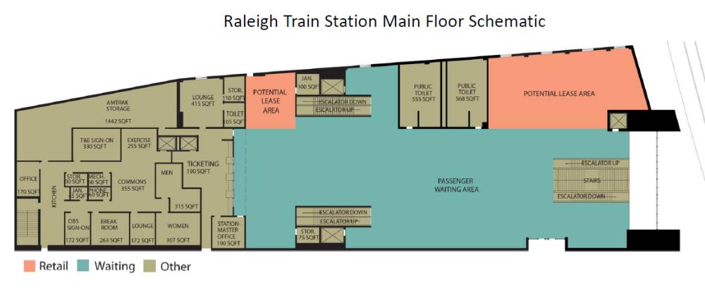
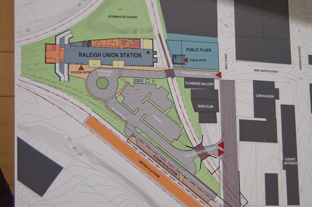
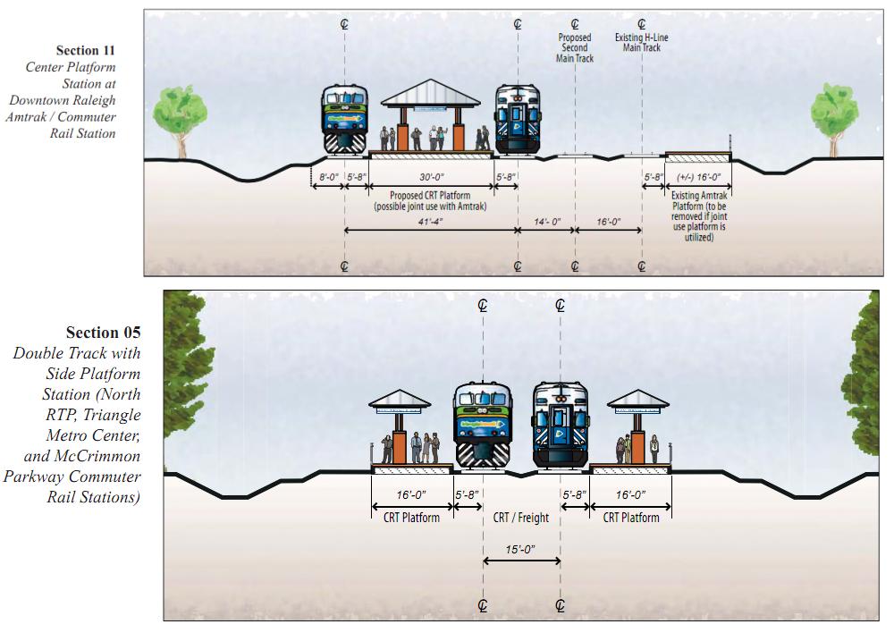
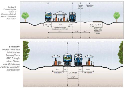
Below is a proposed platform layout for the downtown Raleigh station followed by an example of how other stations might look. The downtown platform would sit between the two tracks rather than having two side platforms.

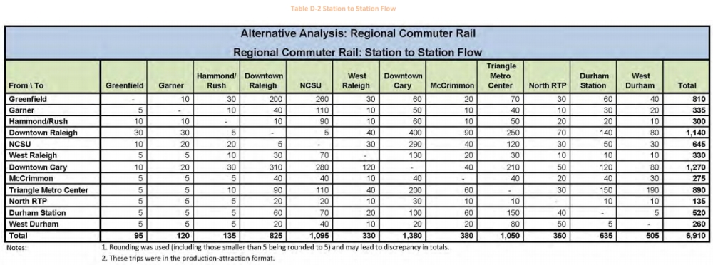
Last, I’ve posted what I think is the most interesting table in all of the documents. Here are the projected ridership numbers from station to station. The table is packed so make sure and click the image to view it larger.

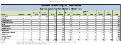
According to the table above, the most trafficked stations will be Downtown Cary, Downtown Raleigh, and NCSU, in that order. You can see that most of the traffic comes between Downtown Cary and to either NCSU or Downtown Raleigh. I feel this is predicting a future scenario where commuters park and ride into Raleigh.

To dissect the downtown Raleigh numbers even further, we’ll start with the 825 arrivals and 1,140 departures figures in the table. There are assumptions that about 15% of trips will be ones that do not involve a person’s home. Thinking about these numbers, this has to explain the difference of 315 between arrivals and departures. (do the math) So an educated guess as to a person’s non-home based trip would be something like leaving downtown to go to the airport for example.

So how can we have more people leave then show up each day? This is what I need to explore more as the numbers suggest that in some cases people will be arriving in downtown using some other method but leaving on the commuter rail lines. If anyone has any information on this I would most appreciate an insight to this.