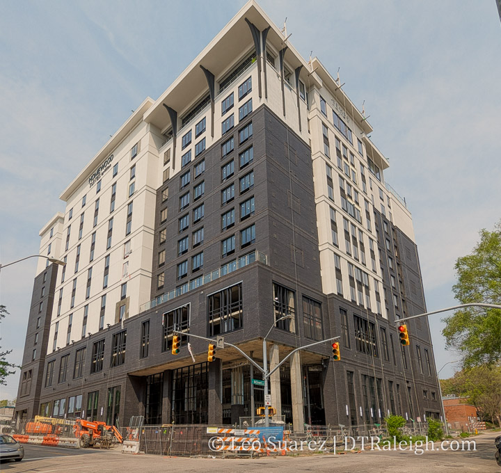
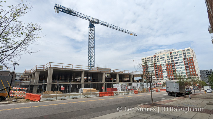
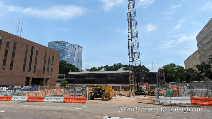
Pic of the Week

The first concrete walls of the The Acorn apartments are standing up straight along Person Street. The apartment phase of the project is underway with plans for a hotel facing Blount Street to come later. I was walking down Cabarrus Street the other day and found this view to be lovely with the crane swinging back and forth and the skyline in the background.

Pic of the Week

This week, I wanted to throw up a picture of the building at 320 Hillsborough Street, currently the Holiday Inn. Site plans have been filed for a new hotel and apartment building that would lead to this building’s demolition.

A new owner has purchased the property here and the parking lot next door in order to build a 20-story building that will include about 180 hotel rooms and 350 apartments. A parking deck and ground-floor retail space is also shown in the site plans.

The “hair curler” was a unique building and it’s unfortunate that a renovation couldn’t work out. No renderings of the new buildings are out, yet, but I welcome completely upgraded sidewalks and the additional street-level activation that the new development will bring.

Taking A Deeper Look Into Glenwood South Crime Data

Embedded above (or here on YouTube) is the video of Raleigh Police Chief Estella Patterson presenting some data and observations about crime in Glenwood South for this year. The numbers are up and it’s been leading to concerns from nearby residents and the council overall.

The News and Observer started things off nicely:

The chief showed crime data comparing the 10 months leading up the pandemic and the last 10 months. Since June 2021, there have been 76 weapon violations, including 64 concealed weapon violations. That compares to 16 violations from June 2019 to March 2020.

There also is a sizable increase in traffic-related violations, but Patterson said the department increased enforcement and the number of traffic stops during that time.

Raleigh police chief makes recommendations to address rising crime in Glenwood South via newsobserver.com

The N&O article also has a graphic showing year-to-date (Jan 1 to Mar 20) figures from 2019 to 2022. Drug-related incidents are up as well as larceny and assaults. As expected, there is a dip in 2020 and 2021 due to pandemic restrictions and lockdowns.

Looking at these figures, I just had to see more as data from 2019 to 2022, with a pandemic right in the middle, may not tell us the whole story.

The Data

I went to the dataset, showing datapoints from June 2014, and built up my own app with charts and tables. You can dive into that here.

The site I built does the following:

  • Shows the Glenwood South map and only takes in incidents that occur inside the boundary area
  • Year-to-date figures for top crime categories from 2015 to 2022
  • Displays Total Yearly Incidents by top crime categories
  • Displays Total Yearly Incidents for all crime categories
  • Pulls data nightly and updates the year-to-date figures

What I’m calling “Top Crime Categories” are the types of crime, as identified by the data, that when summed up, represent about 2/3 of the total incidents. The remainder incident types seem to be so few in occurrence that it’s hard to know if a trend is taking place. I’ll just remove those from the “Top” charts for now.

Top Crime Categories include:

  • Assault
  • Larceny
  • Drugs
  • Weapons Violation
  • Vandalism
  • “All Other Offenses”
  • Drug Violations

I guess I could have added up Drugs and Drug Violations but I kept the data “pure” for now. Also, I’m not sure what “All Other Offenses” means exactly so this one might qualify to be ignored. Take it for what it’s worth.

Last thing to point out, I start with 2015 as the dataset starts in the middle of 2014 so a partial year isn’t helping that much. 2015 is great as we get five full years before the pandemic lockdowns took place starting in March 2020.

Yearly Totals

Indeed, when we look at just the top crime categories as well as all crime categories, the number of incidents has been increasing since 2015. It actually went down in 2018, not by much, but continued on its trajectory in 2019.

Again, the big drop in 2020 is most likely due to the pandemic lockdowns and we can see the recovery in 2021. If we remove 2020, some items to note:

  • number of assault, larceny, and weapons incidents have increased
  • number of vandalism and drugs are more of less the same
  • “all other offenses” has gone down

I’m not sure we can figure out what’s going on but there are some things to note. Consider that since 2015, more development has taken place. The number of residents have increased and the number of restaurants and bars opened has increased.

A good figure to share is from the 2021 State of Downtown Raleigh report which I’ll add here.

Does increased food and beverage sales lead to more crime? Not necessarily but if we think for a moment that there are more people in Glenwood South, leading to more F&B sales, we could argue that more people in a district could lead to more crime. The above figures show a 29% growth in F&B sales from 2015 to 2021 for Glenwood South. In addition:

  • From 2015 to 2021, Glenwood South had an 18% increase in crime incidents overall
  • From 2015 to 2021, Glenwood South had a 36% increase in TOP crime incidents

The real comparison, saved for a later post most likely, is to compare this activity with other districts.

Year-to-Date Figures

The app tracking the data runs nightly so if you want to check back later this year to see how we’re doing, you can do just that. Here’s the snapshot up until April 12, 2022.

Year-to-date figures are pretty much in-line with everything stated above so I’ll leave it right there.

Final Thoughts

The police chief had some suggestions to try and curb this increase in incidents including adding metal detectors at bars as well as changing Glenwood Avenue to a one-way street to keep car traffic flowing more smoothly. A catastrophic incident is not something anyone wants so it’s a good idea to keep an eye on the trends.

We’ll see if any changes come from the city to try and smooth down these numbers. What I really want to see is a comparison of this activity and the number of incidents to other areas to get a sense of context. That’s a post for later this year perhaps.

If you’d like to discuss more about Crime in downtown Raleigh, we have a thread for this on the Community.

Pic of the Week

Raleigh Crossing, or more locally called the Pendo tower, is now officially open. Construction began on the building in late 2019 and the ever-expanding, local startup Pendo is the anchor tenant. This tower is part of a multi-phased project for the same block so there is plenty more development coming here in the near future. (hopefully)

This lot has been something that I’ve watched since the beginning of the blog in 2007. I have a post about the original building at 301 Hillsborough being demolished and plans for an even taller building. That never came to be as these things happen sometimes and a surface parking lot has been the holdover ever since.

The grand opening was quite unique as, in addition to the typical speeches and such, a midair performance took place alongside the building. You just got to see it. See the video below.

A Walk Around Nash Square

I have a soft spot for Nash Square. It’s an urban oasis with city views throughout the winter, leafless months but then becomes an umbrella during the warmer months. It’s also where I got married so there’s that.

Nash Square is more of a ceremonial park rather than one for play and big events. The firefighter’s memorial in the center generates a feeling of pause and reflection. Also, I can’t name a better spot for an outdoor lunch on a park bench than here. It’s just lovely.

While Nash Square isn’t changing any time soon, the blocks around it have some big plans or construction underway. Nash Square bridges the Warehouse District with the Fayetteville Street District. There’s plenty of topics to look at here that I had to map it out. (as I do)

Let’s look at the eight blocks around Nash Square in a clockwise order.

Block #1: Raleigh Municipal Block

The municipal block, or city government block, has the current city council chambers and the Raleigh Municipal Building, shown above. It’s more or less the center of the city government offices and there are big plans for a new municipal campus on this block.

A multi-phased project to put larger towers on the site in order to consolidate the offices of our city’s government has been in planning for a few years. This would most likely see the demolition of the building above and the former Police Headquarters, now empty, next door.

I’ll leave it there but will drop this link to the city’s website for more information. The site lists construction starting in “Late 2022/early 2023”. raleighnc.gov/projects/civic-campus

Block #2: AT&T Building

There are no updates on this block. The AT&T building facing the square has a real nice mural but for the most part, this block is business as usual. I don’t expect much from this block with most of it being the AT&T infrastructure building, First Presbyterian Church, and nice, two-story retail buildings dating from the early 1900s.

Block #3: The Nexus

To the east of Nash Square is the former location of the News & Observer. The Nexus was a multi-tower development planned for this sizeable property but the timing may have been unfortunate as the 2019 plans seemed to be put on hold due to the pandemic.

In March 2022, a rezoning request for the same property was approved, to increase the height limits from the current 20 up to the next allowable limit of 40. (see Z-43-2021, pdf link) Perhaps this suggest even grander plans from the developer? We’ll have to wait and see.

Block #4: Wake County Offices

No plans here, just Wake County office buildings including courtrooms and jail spaces as part of the Wake County Justice Center. The latter being a pretty nice building actually. I love those art deco fins lit up at night.

Block #5: Hotels Incoming

To the south of Nash Square, within the sounds and smells of Whiskey Kitchen, there are three lots worth mentioning. The first has a big crane over it today as a dual-brand hotel is coming soon. A Hilton Garden Inn and Homewood Suites hotel is planned to open next year.

On the opposite corner, we have an empty lot for another planned hotel. Demolition of buildings took place in early 2020 and the lot has sat empty ever since. However, a rezoning is in underway for this lot (see Z-12-2022, pdf link) to increase the height limits from the current 20 stories to the next allowable limit of 40. That likely means construction won’t happen this year as new development plans may be in the works.

Finally, the third lot is the former Firestone lot. It too went through a rezoning in 2021 to increase the allowable height from 20 to 40. (see Z-24-2021, pdf link)

Block 6: Warehouse district historic

The block of 300 West Martin Street is the Warehouse District gem. I feel that without it, there’s just no point in using that name anymore. There are no projects underway but another rezoning is worth watching.

Former plans to build a residential tower behind the buildings shown above haven’t materialized. However, rezoning Z-78-2021 (pdf link) asks for more height and includes conditions to keep the buildings above. The developments are more for the surface parking lots behind the old warehouse buildings. This seems like a nice mix of uses so we’ll see how it goes if the rezoning is approved later this year.

Block #7 and #8: Highwoods Bets on Parking

The block to the west of Nash Square is mostly a mish-mash of surface lots and short buildings. From the square, the Park Devereux condos are the standard for park-side views. I love that building. As for the rest of the block, it’s mostly the same as it was ten years ago.

One exception is the demolition of buildings on the northwest corner for a surface parking lot. Highwoods properties owns this lot and as is their style, they love to sit on parking lots in urban areas.

There are other rezoning cases in place but I’ll punt this one to a July 2021 post that covers this piece of the Warehouse District more in depth.

A 2022 Dive Into Seaboard Station

I’m kind of piggybacking off a post from two weeks ago but either way, I decided to dive deeper into Seaboard Station this week. There’s a lot of moving parts there with a project under construction as well as plans making their way through the approval process for more development. Consider this post a quick catch up and overview of the northern side of Downtown Raleigh.

As always, we’re following Seaboard Station in-depth on the Community, thread is here, so lurk as much as you want but all are welcome to join the conversation.

For me, it’s got to start with a map and I’ve doctored up one such map that I think will help show where we’re at here.

It’s also important to list out what we’re talking about as well as what we are NOT talking about. The map above, modified from the Seaboard Station website itself, shows five key components as to the future development of Seaboard Station. Let’s put a chart together.

LocationWhat’s There NowFuture Plans
Block AFormer Sunflower’s location has been demolished. Empty lot todayHotel, Apartments, Retail
Block BCurrently under constructionHotel, Apartments, Retail
Block CRestaurants and Retail including Galatea, Night Kitchen, and Marigold ParlourHotel, Apartments, Retail
Block DRestaurants and Retail including Ace Hardware, O2 Fitness, and Peace ChinaNone
Logan’sLogan’s Garden ShopRezoning request in progress

As of this writing, these are the only properties we’re talking about. What’s NOT included is the single-story retail strip with shops like Mon Macaron, Hunky Dory, and Sola Salon as well as the Shell gas Station that faces Peace Street. There are also some smaller buildings and lots that are either owned by others or next door William Peace University. There are no plans for those properties as of this writing.

Block A

Block A kind of started things off in 2018 after the sale of Seaboard Station from nearby William Peace University to a developer. Plans included a hotel and apartments, which the website still states is the case. Construction hasn’t started on that however as the pandemic of 2020 made new development take a pause. What was a more solid bet, and still is, was housing which made Block B, with plans for only apartments, more attractive.

I’m speculating here but that seems to be what’s happening now. The former location of Sunflower’s was demolished and Block A is basically a storage yard for nearby construction.

Block B

Block B is close to topping out. About 300 apartments with ground-floor retail should open later this year. This is the first development of the new era of Seaboard Station. The units on the east side looking at the university should have a nice view.

Block C and Block D

Block C and D are still in the planning phases. I got nothing on Block D as the attention has mostly gone to the other areas.

Site plans have been submitted (see ASR-0033-2021, pdf link) to the city for Block C showing another apartment over retail building with around 220 units. However, there is still active retail on this block. I’m hoping that spaces in Block B are offered and time is given to the local businesses to move over.

Logan’s Garden Shop

Logan’s has hit the news recently with an announcement of moving their business in the future. This is a “years from now” announcement and no changes will take place soon. However, in the background, the developer has filed for a rezoning. (see Z-5-22, pdf link) The current zoning has a seven-story heigh limit and the owners want to increase that to 20.

The local controversy here is the train depot building that once served the Seaboard rail line. The new development suggests the replacement of this building. However, no site plans have been submitted as the rezoning really dictates what can be built here or not. It’s my understanding that the building has no historic status and therefore can be demolished today, rezoning approval or not.

At the same time though, the building is in great shape from what I can see and would be a nice touch to an area that will mostly feature “by-the-book” 5-over-1 generic buildings.

The Logan’s property is mostly surface lots around the station including the train canopy and yards that currently serve the garden shop. New development would be a significant boost to the area. Building massings, such as the one below, are being worked on but no definitive plans have been put out there.

I tend to take the contrarian route on most “historic preservation” issues. I say we give them all the height allowances with the stipulation that the station must be preserved. At the same time, if hundreds more residential units or office spaces are built at the expense of the station then I won’t cry over that. I see no way Downtown Raleigh loses here.

Seaboard Station, a glorified shopping center really, is going through an urban transition. The residential units are welcome, especially at a time when there’s a housing crunch in Raleigh, and I can’t think of any better way to make urban retail work then to stack hundreds of residents on top and around you. That’s really what the downtown Raleigh of the future looks like to me.

You can also insert a lengthy argument about putting tall buildings around future transit lines here which I’ll save for another day.

Seaboard Station is on the path for more people spaces with less car spaces. I think this future Seaboard is going to look great.

Parking Minimums Removed Across the City

This week, the Raleigh City Council voted to remove all parking minimums for new developments across the entire city. This extends a previous parking reduction that was done in 2020 that mainly affected the downtown area. You can watch the discussion and vote in the embedded video above or directly on YouTube here.

It is worth reiterating that parking is not banned city-wide. It only removes the minimums required and, generally speaking, allows new projects to choose the amount of parking to be built. In some cases, there are maximums in place.

From what I’m seeing, right now new buildings in downtown are building above the minimums anyway. In the future, as transit options come online and our city adds more people, those who prefer to travel car-light or even car-less will benefit from a city that doesn’t dedicate so much space to parking vehicles.

Indeed, climate impacts and sustainability is a big driver of this change, as written out in the text change itself.

SUMMARY OF IMPACTS

Adoption of TC-11-21 would:

1. Because it removes subsidies and incentives for car ownership (because rent typically does not vary depending on whether a car is stored on a property or not, so there is no extra cost for car ownership) it would tend to reduce vehicle miles traveled and associated air pollution and carbon
emissions.

2. Mitigate the climate change, stormwater, and other impacts created by large areas of paved parking.

3. Tend to reduce the cost of housing and goods and services by requiring less land to be used for vehicle storage. It would prevent households without cars from paying for parking they do not use.

4. Potentially lead to increased demand for on-street parking in some locations. If issues arise, excessive demand can be addressed through the creation of new residential parking permit areas, adjusting on-street parking pricing, and providing additional public parking.

https://go.boarddocs.com/nc/raleigh/Board.nsf/files/CC5L9Q54981F/$file/20220315PLANDEVTC-11-21StaffReportandDraftOrdinance.pdf

From a sustainability and land-use point-of-view, I think it’s great to address problems of having too little parking on a case-by-case basis (point #4) rather than the problems of having to much. Well managed on-street parking programs are common in larger cities and it’s probably time Raleigh get into that game.

The change is a great, incremental step in the right direction and it’ll take time for the city to adjust. The next step will be to give Raleighites a transit system that allows for all of us to get around while putting less miles on our cars. That kind of Raleigh may lead to shorter buildings (less floors for parking), more destinations closer together, and more vitality to neighborhoods.

Pic of the Week

The first major building of the future Seaboard Station has really been moving. I believe this is the first residential building for the area in quite awhile, maybe ever. Seaboard Avenue is a mess right now and with future construction planned, might as well get used to it.

More rezoning requests are in the works for the western part of the Seaboard Station area as well so we may have a crane over us for a few years each time you visit Seaboard.