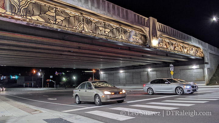
Have you been under the Capital Boulevard bridge at night lately? It seems like it was delayed (what isn’t delayed these days?) but the art installation for the bridge over Peace Street looks finished and is lit up very nicely now.
I’d like to think this project is finally done now that the lights are on. The Capital Boulevard project is a pretty long-lasting one as far as this blog goes, with posts about it going back to 2010. The area will probably see even more public investment as Devereux Meadow park, right next door to this bridge, goes through its planning phases.
Things have been slow at DTRaleigh HQ with some recent holiday downtime. (I hope the same for you as well) Also in the background, I’ve been flexing my tech skills a bit and working with maps lately. I went down a rabbit hole with the zoning information on the city’s open data website and started thinking about building heights.
But first, a refresher.
For the longest time, Raleigh’s zoning code had two limits with regards to building height; number of floors and the measured height in feet. To a certain degree, the “height in feet” limit has been removed and today, only the number of floors is the limit we care about. That may not be true city-wide but seems to be for downtown Raleigh, where we see a concentration of floor limits as high as 40.
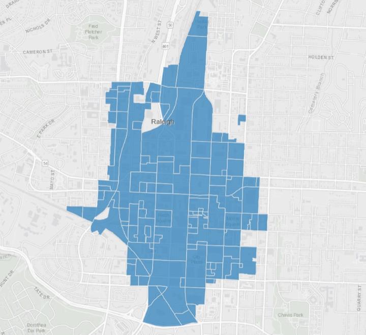
Since this is a downtown Raleigh blog, let’s look at just that. Downtown is, generally, given the DX zoning type. You can see a map of all zoning in Raleigh here but if I filter on just downtown, it looks something like this.
After filtering the dataset and looking only at the ‘DX’ zoning type (DX = Downtown Mixed-use) we can see areas that we generally refer to as Downtown Raleigh and shapes on a map with different zoning. To quickly read zoning labels in Raleigh, the formatting typically goes in this order:
Zoning Type
Maximum height allowed
Frontage type
So for example, when I see ‘DX-5-UG’, that stands for ‘Downtown Mixed-Use with a 5-story height limit, Urban General frontage’ There are a bunch of frontages that are worth going over but that’s for another day. Today, I’m looking at that middle number only.
I wanted to get a sense of what the maximum heights allowed are but the map above doesn’t show it to me easily without clicking every shape and noting the zoning. I went ahead and created this map below which shows darker shading on areas that allow higher heights, such as 12, 20, and 40 story maximums. Conversely, the lighter shading indicates lower heights including 3, 4, 5, and 7 story maximums.
The map is using the same dataset from the city so it should be up-to-date whenever you look at it.
It’s probably obvious to guess that the tallest height allowances are around Fayetteville Street. Two Hannover, with the newly renamed Truist Bank on its crown, and the Wells Fargo Capitol Center have been around since the early 1990s. When you add in PNC Plaza, opened around 2008, the thought of our city’s tallest towers and where they are doesn’t surprise anyone. Taller towers nearby are allowed and could come to this area in the future.
The map does show some easily explained anomalies such as the five-story maximum at Martin and Fayetteville. This is where the historic post office sits and since that’s not going anywhere any time soon, a rezoning just seems silly. Open space on Moore, Nash, and Union Square follows the same principle with their 3-story maximums.
If you are following me so far, you may think that the tallest towers in downtown have always been, and may always be, situated around the core business district around Fayetteville Street. That seems like a trajectory that downtown has been on since we started calling it downtown Raleigh.
However, there are other districts that now have 40-story maximum zoning. I say ‘now’ as these have been approved within the last few years. If I take my map and filter on only the DX zoning type with max heights at 40, we would get a visual that looks like this.
In this map, we can see two clusters of 40-story max zoning outside of the traditional downtown core of Fayetteville Street, those being the warehouse district and the northern end of Glenwood South. If we look at the effective dates of the zoning in these two areas, they are all in 2019 or later.
Just a side note, from the data for the whole city, it looks like the rollout of the newest zoning per our development ordinance was throughout 2016 so while we see some zoning in downtown effective as of 2016, there’s a lot of it across the city. I want to say this was the transition from the old zoning codes to the new ones so anything with a 2016 effective date was not a market-driven zoning change more or less.
The maps above show current zoning and doesn’t consider active cases under review. As of this writing in December 2021, we can further show this clustering activity if we consider the in progress rezoning cases in downtown shown in this table.
You can see that the first four cases listed above show more height in the same districts with three of them within these new clusters at the 40-story max height. Glenwood South and the Warehouse District are poised to really add much more space.
Why might this be happening? Is this an accident? Actually, it’s all according to plan.
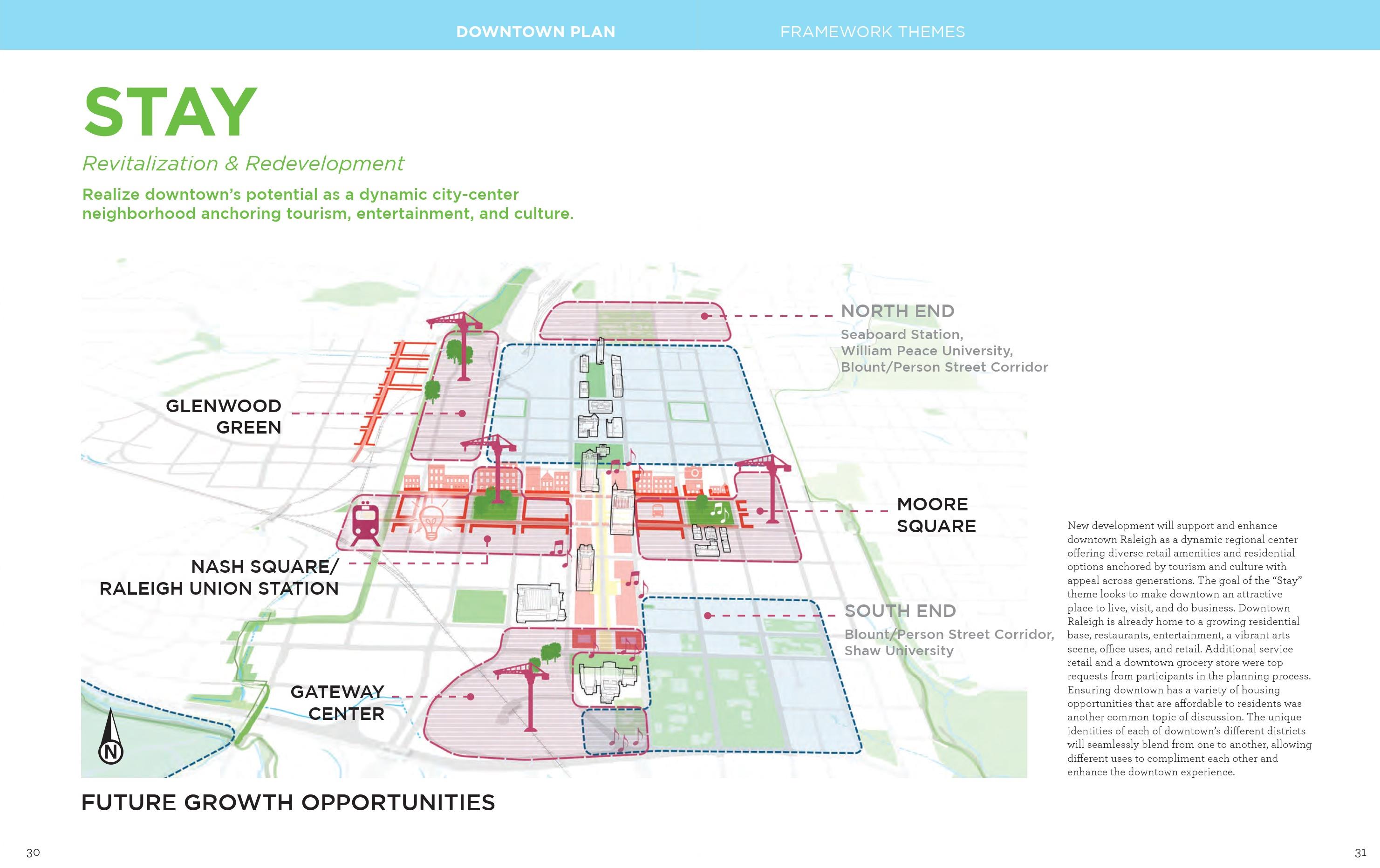
Adopted in 2015, the Downtown Experience Plan has many recommendations in it and a subset of redevelopment recommendations suggest we are right on track. You can dive into the plan here. (pdf link) I mean, this image alone from the plan is spot on.
We have talked plenty about the downtown plan over the years, which you can revisit here, and it’s recommendations say they are for 10 years. Perhaps later this decade it’ll be time for a new one?
I could keep going with thoughts about all this rezoning. Remember that maximum height doesn’t mean the buildings are built that high. Also a 20-story residential tower is shorter than a 20-story office tower. Zoning seems to be enjoyable to the civic geeks out there because of all these nuances, am I right you all?
There’s also a pretty wide gap between the 20-story max zoning and 40-story max. If a developer only wants to build a 23-story tower, they must apply for that 40-story max. Height conditions may be a thing of the future as the eastern most shape on that map above, the one by Marbles, has a condition limiting it to 30 floors. (Nuance!)
The main takeaway that I think I’ve gotten at is that we all need to be watching the Warehouse District and Glenwood South as they may really see a jump in development this decade. If these rezoning cases to new heights seem like a drastic change, just look back and see that it’s all part of Raleigh’s plan.
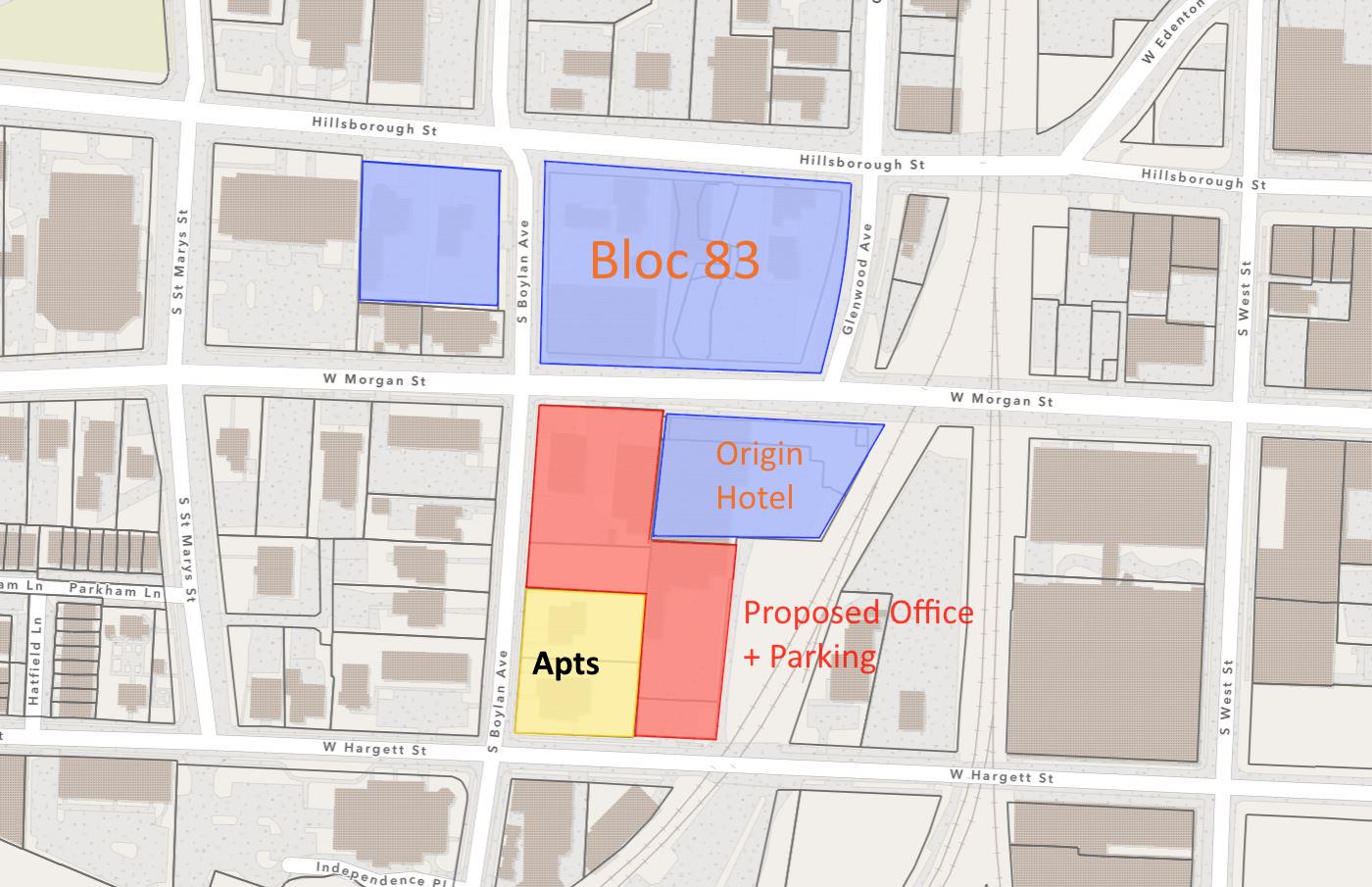
The finishing touches were put on the Bloc 83 project earlier this year but the growth around Morgan and Boylan doesn’t seem to be over yet. Two projects worth following are planned along Boylan Avenue between Morgan and Hargett Streets. They both will be bringing more office space, more residential units, and probably just enough parking spaces that FINALLY, we can do away with the complaint that you can’t park in downtown.
First, let’s map it.
Shown in blue are the Bloc 83 projects that are already up and running. These include the office buildings, One Glenwood and Two Hillsborough, the Origin hotel, and two parking decks.
For the future, another office tower is trying to get built at the corner of Morgan and Boylan, shown in red on the map. The rendering at the top of this page is for this project and shows off the 11-story building. To provide even more parking for the building, the red portion on the map to the southeast would add structured parking to an existing surface lot. The building will also provide ground-floor retail space.
Next door, another developer has plans for Bloomsbury, a 135-unit apartment building. This will be at the corner of Hargett and Boylan. Studio, one, and two-bedroom units will be offered over ground-floor retail spaces. The building will be seven stories tall.
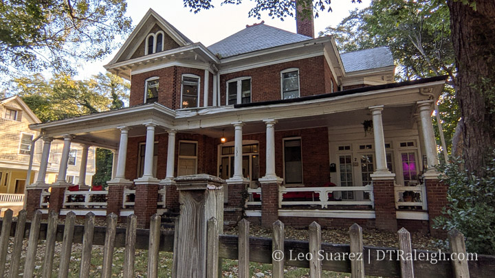
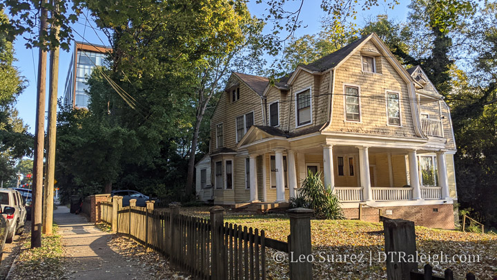
The 100 block of South Boylan will feel entirely different after this infusion of mixed-uses. Currently, the eastern side has a few one-story brick warehouses used for retail and two older homes that, to the best of my knowledge, are broken up into a few units. There are no definitive plans of moving the homes, which look great by the way, so let’s hope someone steps up to move them. They would fit in nicely in Boylan Heights.
This is a bit of a different post this week. Below is a video of a presentation I gave to the downtown Raleigh Rotary Club. After introducing myself, I made a list of 10 interesting things I’ve noticed after blogging for so long. It’s a presentation I need to refine and improve so hopefully putting it out there helps myself for future presentations.
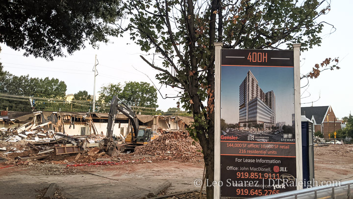
This week, the buildings along the 400 block of Hillsborough Street are being demolished to make way for the 400H development. This mixed-use project has been years in the making and you can check out former posts about it here. The new development will include a mix of uses with over 200 apartments, 144,000 square feet of office space, and ground-floor retail.
The building is expected to finish in Fall 2023.
In recent memory, I don’t recall that many occupants for the spaces on this block. There was a small gym and perhaps some offices but the larger space on the northeast corner of Hillsborough and West Street has been empty ever since I’ve started blogging. (since 2007 by the way)
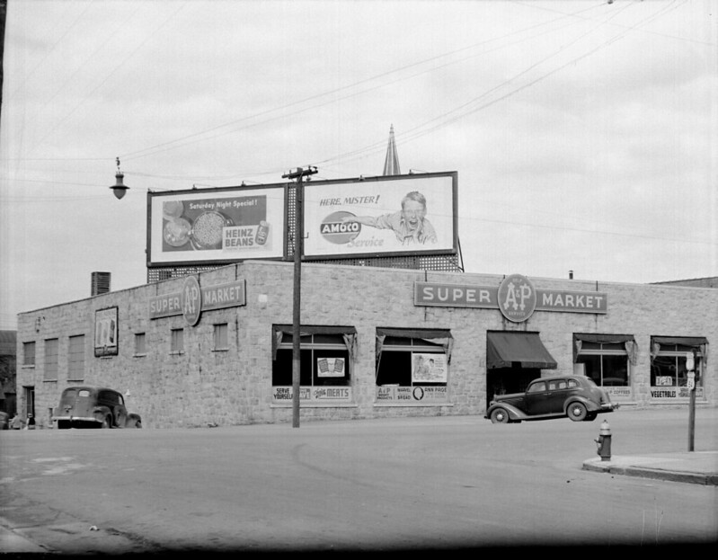
If you like Raleigh history, you may be following Olde Raleigh, and have seen the post of the A&P Supermarket at the same site. From their post:
Pictured is the A&P Supermarket located at the northeast corner of Hillsborough and West Streets c. 1946. This building was constructed around 1929 and later burned in 1952, but the stout stone walls remained intact. Although the building has changed considerably since 1946, you can still see some of the original stonework on the western side.
See the post on Facebook
Photo by Albert Barden. From the Albert Barden Collection, State Archives of North Carolina, Raleigh, NC. N.53.15.2412
The photo is from the Albert Barden Collection courtesy of the State Archives of North Carolina. You can browse the collection on Flickr.
South Street seems to come in waves here on the blog. This time around, we have a few items to mention as the Western portion of the street has new activity worth mentioning.
First, plans have popped up on the city’s website for a new apartment development. Named 320 West South, 296 apartments are planned for the corner of Dawson and South in a 20-story tower. The new development would be situated right next to the storage building.
I propose we rename the warehouse district to the rezoning district. I’m kidding of course but with a pair of approved rezonings earlier in July of this year plus plenty of cases in the recent past, you can’t deny the potential for multiple new projects adding a lot of new space to the area. It’ll be quite a change!
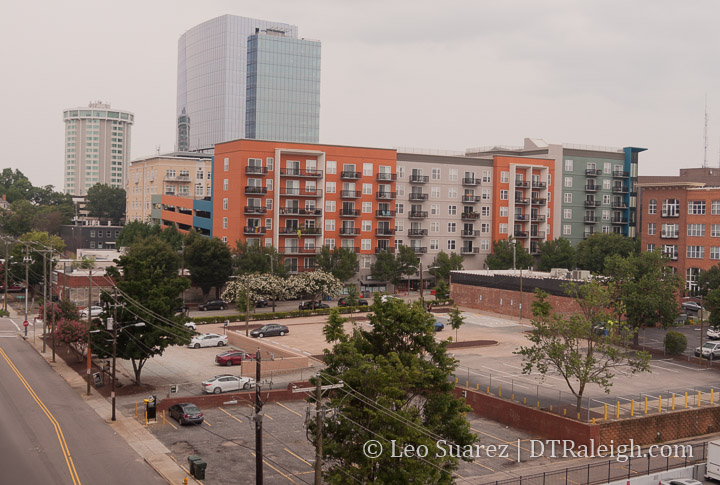
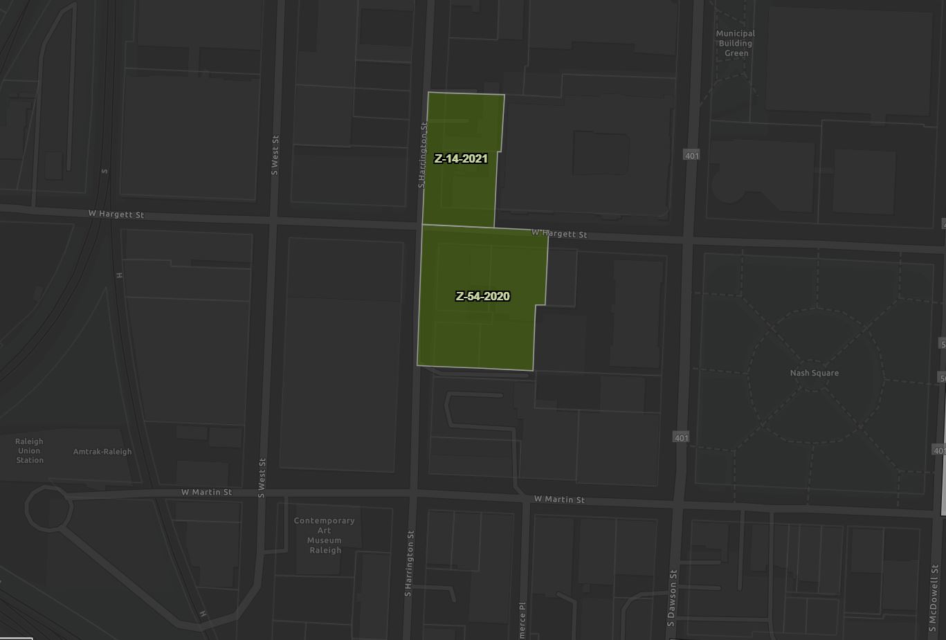
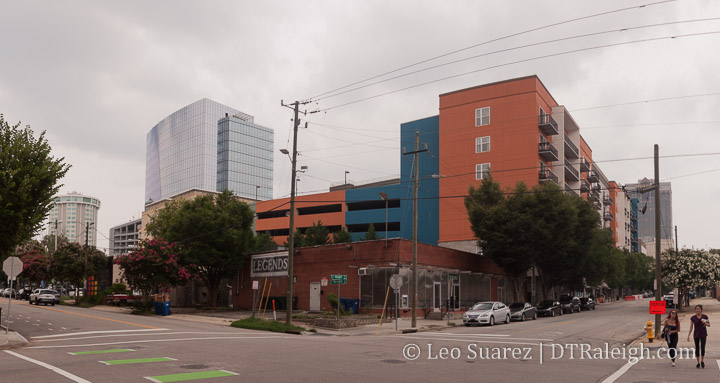
Approved recently were two cases around the intersection of Hargett and Harrington. Mentioned earlier this year, the “Legends block” was approved for a max-height of 40 stories. Across the street, now a parking lot owned by Highwoods Properties, is another piece of property with a similar 40 story max zoning.
There’s not much else to add about the Legends parcel in that it includes the entire building, front and back bar, and the small parking lot along Harrington. No details as to what is planned have been released. The owners of the property is CityPlat, a local commercial development company.
The owner of Legends was quoted in the News & Observer that the deal here was a positive thing for the business.
“The deal with CityPlat ensures the long-term survival of Legends as an on-going business and an opportunity to collaborate for future development,” said Tim Bivens, one of the club’s owners, in an email. “We are coming up on our 30 year anniversary and plan to be around for another 30.”
Downtown Raleigh LGBTQ club Legends sells property for $4.3 million – link
The Highwoods Property on the other corner was mostly surface parking. The surface parking expanded with some buildings being demolished in February 2020. It’s not even fully paved, a move Highwoods seems to be fond of like their property on the corner of Wilmington and Martin. Similar to Legends, no details on future plans have been announced.
What gets me excited about this potential is the possible future for a nice two-block street of retail and restaurants. 300 and 400 West Hargett could have retail facing each other on both sides of the street on their ground floors. That’s actually quite rare in downtown outside of the Fayetteville Street core and Glenwood South.
Long term, we have planned bus-rapid transit and an already running train station nearby with plans for commuter rail. Office, residential, or even hotel uses could be nicely served by these alternative transit options.
Things have come together and over on the Community, we’re talking t-shirts. We have a slick design from the 919 Collective and I want to thank them for the contribution. Think MLB Raleigh for an already underway initiative to compare these shirts to. More on them in the future.
Deadline for t-shirt orders is this Friday, July 16 at midnight. Want one? Keep reading.
To get a shirt, simply make a donation here and include a comment with what you need. We’re looking for:
Quantity of shirts if you’re ordering more than one
Shipping info if needed. Please add $5 to your donation to cover shipping costs.
I’d prefer to hand over the shirts in person at a meetup if possible to keep this as simple as possible but I’ll make every effort that I can to get you your t-shirt once they are in.
Of course, feel free to contact me if you have any questions. Donations are going towards covering the t-shirt order as well as supporting this site and the Community.