Pic of the Week

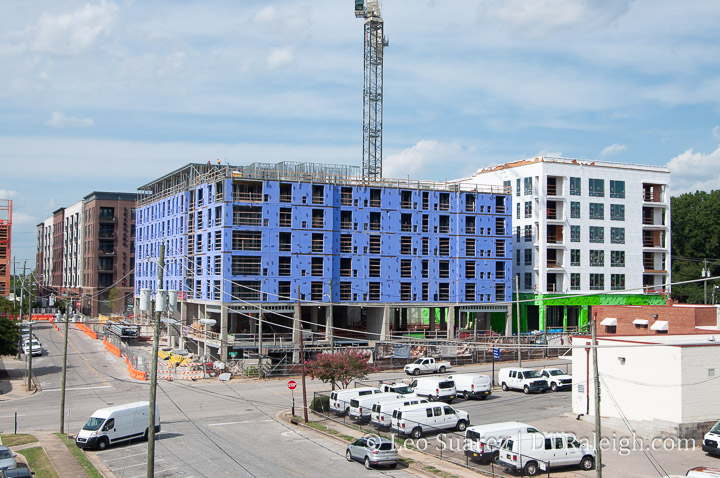
Seaboard Station is really humming. In the foreground above, Block A has been cleared even more with the former parking lot stripped away and trees removed. This piece will have hotel and apartment units.

In the background, Block B is getting bricked up and looking real nice. I expect the crane to come down soon but maybe it’ll be moved to Block A. Just a guess here.

Block C, not shown above, has fencing around it so perhaps demolition is upcoming. For a refresher on the layout of Seaboard Station, see this March 2022 post.

After Successful Rezoning, Legends to go up to 30 Stories for Residential

An administrative site review has hit the city with high-level plans for a new tower along Harrington Street. The Legends nightclub at 330 West Hargett Street (corner of Hargett and Harrington) would be demolished to make way for a new tower and parking deck, the site plans show.

The new tower would have 372 apartments, ground-floor retail space, and a parking deck. The plans show all these offerings in a 30-story tower. The building where Legends is located isn’t the only one getting the “demosh” as the tower actually goes along Harrington between Hargett and Morgan. Two buildings along Morgan, being used as office space today, will also be demolished for the new tower.

With a narrow lot, we’re getting a pretty thin tower compared to the current downtown Raleigh building stock. The parking entrance/exit will be along Morgan and the service/loading entrance is along Hargett. This shifts the ground-floor activity up and down Harrington Street. That seems necessary with a tower this size but is disappointing as Hargett was identified as a key pedestrian-retail street per the 2015 downtown plan.

Below is the view, from the site plan, staring at the tower from Harrington Street followed by the view from Hargett. (as if you’re looking at Legends’ front door)

That block will be pretty built up with over 600 homes, probably, when you include The Dawson and The Hue. Nearby, The Dillon has over 500 units and construction is starting on another residential tower over at the future Raleigh Union Station Bus Facility.

The latest news has construction starting at the Legends lot in early 2023.

A Walk Around the Char Grill Block

In June, the city’s neighborhood meeting calendar posted an update for a possible rezoning for properties along Hillsborough Street including the beloved local spot, Char Grill. The news picked it up. Comments were made. Opinions were everywhere.

To be clear, the rezoning request has not been submitted as of this writing but I want to mention two items right up front:

  • Char Grill owns their lot and plans to incorporate a Char Grill location in any new development
  • Comments from them suggest a thoughtful development with respect to any historic structures nearby

Instead of typing out comments online and looking at Google Maps (well I did some of that) it was time to get a steak junior and walk the block.

NOTE: I call it the “Char Grill Block” since that’s the most important thing there (let’s be honest) but not all properties are planned for a rezoning.

From the neighborhood meeting notes, the following properties seem to be targeted for rezoning. Char Grill is on the southern end about midway between Boylan and Glenwood.

Walk the Block

Let’s start with Char Grill and go clockwise around the map shown above. Since the rezoning application hasn’t been submitted yet, I’m also not going to get into possible heights and conditions today. Let’s just look at buildings.

Char Grill doesn’t need an introduction here. Open since 1959, the burger and fries spot has one of the best walk-up windows in downtown. It’s not exactly a drive-thru in the modern sense but plenty of space is given to parking also.

On the corner of Hillsborough and Boylan is a closed gas station. Built in 1952, it has gone through a variety of gas and car service brands. Today, it seems to be used for parking for nearby construction projects. When I was walking around, there is work going on for something in a retail space across the street at Bloc 83 and the workers were parking here.

Next is a gravel parking lot. Not much else to add here.

The environmental engineering firm Smith Gardner operates out of a few houses on this block also. Along Boylan, is this red brick house from 1910. Employees probably park in the adjacent lot.

At the corner of Boylan and Willard, we have Elmwood. Elmwood is a beautiful house from 1813 and is currently used as office space. Elmwood sits on the National Register of Historic Places. The side yard along Willard is a gravel parking lot.

Finally, there are two more 1910 homes along Willard being used as offices by Smith Gardner, shown above. Their backyards are basically gravel parking lots also. Turns out, all three houses that Smith Gardner is using is owned by the same company.

Speculation

No details are out there of what is going to be built, we’re not at that stage yet. I feel in the minority here as Elmwood, not Char Grill, is the property I’m most interested in with respect to any new developments. Of course, people are most distracted by the Char Grill being demolished, the youngest building mentioned in this post, but I’m in the camp that honestly thinks they could use an upgrade. (or at least a serious power wash)

For me, Char Grill’s walk-up window is fantastic. If the new development can get a Char Grill in there with an active walk-up window, some outdoor tables, and indoor seating like their newer locations, it’ll still be a hit.

Focusing on the older homes behind Char Grill, you can’t help admit that there is a lot of gravel parking spaces that could be used more efficiently. The brick building at 14 North Boylan could be moved to sit on Elmwood’s gravel lot. If you do that, you square up a nice property for some taller development. It could look something like this.

Again, just speculation but the houses can be saved and the red square in my sketch up here can be developed. If the houses continue to be office space, parking can be tucked inside the new development.

We’ll get back to this once the rezoning is submitted and discussion by planning commission and city council takes place. Until then, keep eating steak juniors.

New Office Developments Planned as part of Latest NC Budget

Adopted this July, the North Carolina Legislature’s 2022-2023 budget has a few items worth noting for the downtown government office complex. Probably the quietest part of downtown Raleigh, the government complex is a collection of office buildings housing many departments that work and support the state-level government.

Continue reading →

Pic of the Week

For those who want more green buildings around downtown Raleigh, sadly the condos at 615 West Peace Street will not be working out for you. The building is getting closer to completion and bricks should be going up as you are reading this post.

Condo buildings like this are a rare specimen these days. It might be worth checking back in and seeing how it did in the end once it opens up later this year or next.

320 West South Breaks Ground, Sets up Fancy Fences

Ground has been broken at 320 West South Street for 320 West South. The completely unique and originally named apartment tower will bring almost 300 apartments in a stand-alone tower. In addition, ground-floor retail space is planned and the parking deck will be built next door.

If you see in the photo above, the tower will bookend the 300 block of West South Street with the parking deck massaged between the apartment tower and the storage building currently up on South Street. It’s not a bad location especially when you look at a rendering such as this one.

I’m not sure there is a bad view here. I’m really hoping that this is a green or “green” roof there on that parking deck. We’ll get to watch this project rise up throughout the year and next as the tower is planned to open sometime in 2024.

Mapping Raleigh: Buildings by Year Built

Lately, I’ve been less active on the front-side of the Raleigh House of Connoisseur but have been heads down working with creating a new map. I don’t think I’m finished and honestly, haven’t even started any type of analysis, but I wanted to put an update out there and share something with readers.

TLDR? Just go here to the map.

The Background

I was inspired when I stumbled on this map of Paris, introduced by the tweet shown below. Technically, it was something I wanted to see if I could build for Raleigh but also, it would be interesting to see how the buildings of today have held up. Are we seeing “mass teardowns” as some people think? What other questions might we begin to answer?

I then found the “ingredients” on the city’s open data websites around Raleigh parcel data and using the “year built” field, I starting analyzing over 130,000 pieces of data.

The Map

The map I put together shows Raleigh’s existing stock of buildings as of May 2022. It’s important to note that this is a snapshot in time, not buildings constructed over time. For example, if a home built in the 1950s was torn down for a new construction home in 2015, the parcel would show in the 2010s decade, not the 1950s.

https://develop.dtraleigh.com/buildings/

Please note that the property shapes have been optimized so that the map is somewhat usable. Don’t take them literally.

I grouped properties by decades with an additional “Pre-1920s” category. This was driven mostly by number of buildings as the counts before 1920 is pretty low. Here’s a bar chart.

That it?

Probably not. I’m releasing it into the wild and see how it sits for awhile. We are discussing it on the Community on this thread so if you have any questions or thoughts, please join us.

I’m hoping to continue tinkering with this map and see what we can extract from it. Questions I have could be:

  • Are there neighborhoods that have been completely turned over?
  • Are certain neighborhoods less susceptible to teardowns than others?
  • Where do you see a mix of buildings being produced at a constant rate?
  • Why is the building count in the 2010s so much lower?
  • How might annexations and border expansions played a role over time?
  • How might protectionist overlays, like NCODs and historic overlays, played a role?

Expect follow up posts in the future.