Introducing Link Peace Street, A Resident Backed Alternative For Capital Boulevard and Peace Street

Peace Street with Capital Boulevard bridge

There’s a new project that’s growing some legs in downtown Raleigh. Link Peace Street is a vision from Raleigh residents for a more walkable environment on Peace Street. It coincides with the Capital Boulevard Corridor Study and hopes to put another alternative onto the table that is currently not being considered. I’m helping out with the effort and the core focus of it revolves around creating a plan for an at-grade intersection at Capital Boulevard and Peace Street.

Over the next few days, more information will be put onto the vision website of Link Peace Street so I encourage readers to check out the site we’ve built and sign up for updates.

Link Peace Street revolves around three main goals,

  1. Economic development in a form that fits into downtown Raleigh.
  2. Strengthen the connections between neighborhoods.
  3. Deliver on the 2030 Comprehensive Plan.

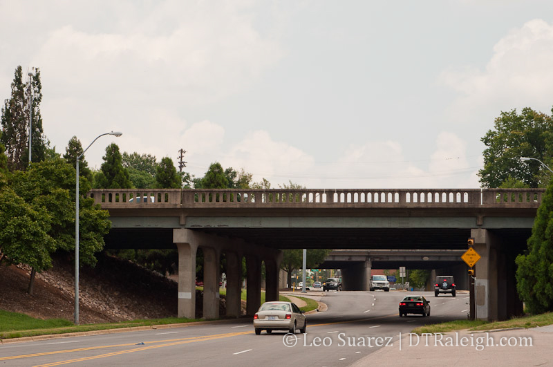
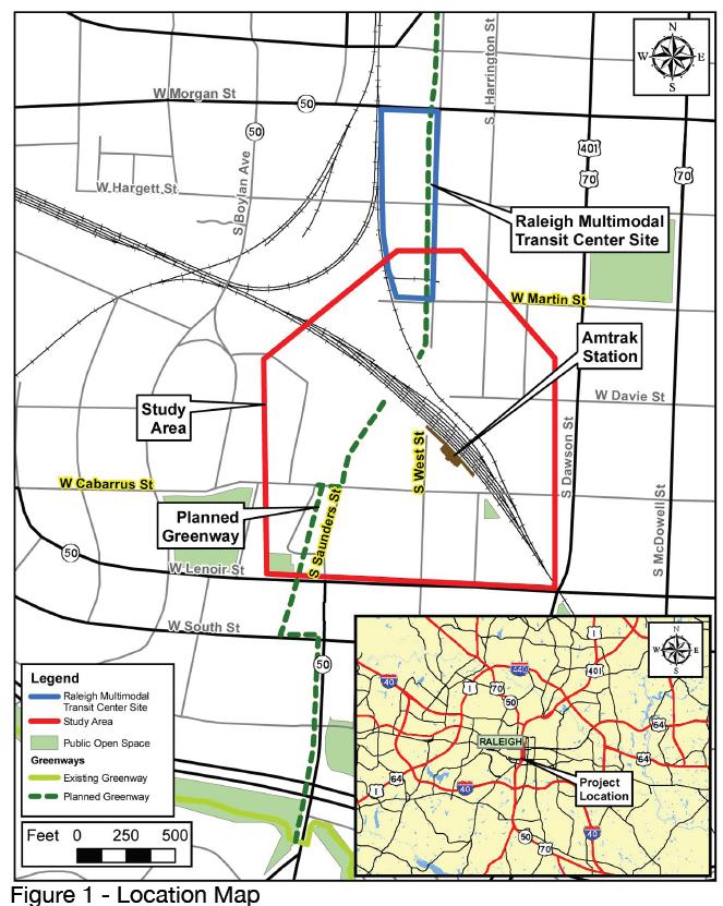
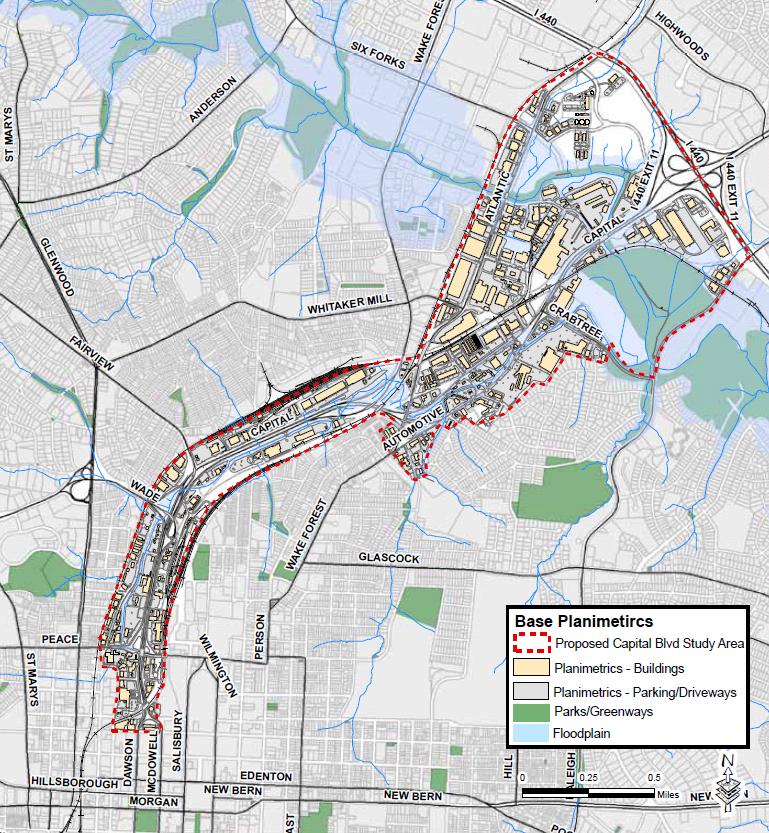
The Capital Boulevard Corridor Study, taking public comments at this time, targets private investment in the area using several projects. Some of those include an expanded greenway, a park at the old Devereux Meadow site, and multiple tweaks to Capital Boulevard itself. We’ve mentioned here before that the state of North Carolina is going to replace the bridge over Peace Street within a few years. The study wants to piggyback on that project and is considering some alternative routes to getting on and off of Peace Street. You can read about those alternatives on the Peace Street Vision document in the sidebar on the city’s website. These ideas are what planners think will help spur private investment in the area.

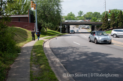
All plans being considered so far include the new NCDOT designed bridge and Link Peace Street wants them to consider the ‘no bridge’ option. We feel that the upgrades to Capital Boulevard, outlined in the study document, only promote more speed and will continue keeping vehicles moving through the area rather than stopping at a destination. Peace Street is the northern border of downtown Raleigh but most people don’t see it that way as the built landscape is not meant for a downtown at all. It’s possible that an environment that balances pedestrians, cyclists, and vehicles can promote development that is appropriate for downtown Raleigh and is a much better use of land.

With vehicles speeds kept the same and not increased, a walkable Peace Street will connect the neighborhoods rather than be an obstacle between them. In March, the Blount Street Commons project was asking the Raleigh City Council for a zoning change to allow for more density. At the same time, there is an apartment boom near Glenwood South. Both neighborhoods are so close yet feel much farther because of the uneasy walk down Peace Street in its current state.

It is a half mile walk from the Mellow Mushroom to Tyler’s Taproom yet so few people make that walk. In comparison, Fayetteville Street from one end to the other is a half mile. Peace Street may never have the towers and historic structures of Fayetteville Street but we think that we can atleast set up Peace Street for the same walkable experience. To have it, it starts with people and not vehicles.

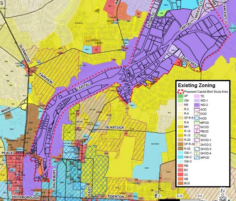
The 2030 comprehensive plan specifies that this area is in the Core Business District category. It states:

This category applies to the Raleigh Central Business District, and is intended to enhance Downtown Raleigh as a vibrant mixed use urban center. The category recognizes the area’s role as the heart of the city, supporting a mix of high-intensity office, retail, housing, government, institutional, visitor-serving, cultural, and entertainment uses. Multiple zoning districts apply within the CBD, corresponding to the different character and vision for its various neighborhoods. The maximum residential density in this area would be 320 units per acre with densities tapering off towards edge areas adjacent to established residential neighborhoods, but not falling below 40 units per acre.

The Capital Boulevard study wants to widen lanes and help the flow of traffic. This does not fit with the description above and Link Peace Street feels that goes against the plan adopted just a few years ago.

How can we continue to do what we’ve been doing here in the corridor and expect different results?

Insanity: doing the same thing over and over again and expecting different results.

-Albert Einstein

We’re hoping to build support for the idea before the study is brought to the city council before the May 1st meeting.

NCSU Landscape Architects Show Off Vision For Capital Blvd on First Friday

First Friday is filled with tons of great events and things to see. Since we’ve been following the Capital Boulevard corridor study, there’s one event I wanted to highlight. Landscape architecture students from NC State will be showing off some of their designs for the Capital Blvd corridor at the Urban Design Center tomorrow starting at 6pm.

Currently, the corridor study is pretty wide open so new ideas are welcome. I’m hoping to see designs for the corridor that balances the people aspects, sidewalks, parks, with the need for transit, mainly cars, which is what currently dominates there.

Urban Design Center
133 Fayetteville Street
6pm

Capital Boulevard Corridor Study Open House On September 29, 2011

From my e-mail directly to you, take note of this upcoming meeting on the Capital Boulevard Corridor Study.

Where: Progress Energy Center for the Performing Arts in the Meymandi Concert Hall and Lobby
When: September 29, 2011, 6:00 p.m. – 8:30 p.m.

Related link:
Capital Blvd Corridor Study via RaleighNC.gov

Raleigh residents are encouraged to attend the Capital Boulevard Corridor Study open house and public comment opportunity on September 29 at Meymandi Concert Hall. The open house is a chance for residents to hear plans and options for one of Raleigh’s main thoroughfares.

The corridor study will look at options regarding the roadway, transit and high speed rail, bicycle and pedestrian needs, greenways, stream restoration, and economic development along Capital Boulevard. Representatives from the North Carolina Department of Transportation will be on hand to discuss the replacements of the Peace Street and Wade Avenue bridges. Residents are invited to make comments and ask questions about the corridor plan.

The meeting will be an open house format held in collaboration with NCDOT. Displays will include:

  • The City: vision options for the corridor including roadways; transit and high-speed rail; bicycle/pedestrian; greenway and stream restoration; and economic development
  • NCDOT: bridge replacement plans at Peace Street and Wade Avenue for public comment
  • Triangle Transit: rail alternatives under recent discussion
  • Southeast High Speed Rail (SEHSR) plans under development

Bridge Replacement Projects On Capital Blvd

Capital Blvd is getting a little planning love from NCDOT. The bridge over Peace Street and the Wade Avenue flyover are in pretty bad shape. Both are on the books for an upgrade. From the NCDOT’s project page:

The bridge on Capital Boulevard over Peace Street (Bridge No. 227) was built in 1948 and has a sufficiency rating of 42.9 out of a possible 100. The bridge on Capital Boulevard at Wade Avenue was built in 1954, has a sufficiency rating of 34.1, and is posted with a weight limit. Both bridges are structurally deficient and functionally obsolete. While the existing bridges are still adequate to support traffic, they are nearing the end of their design lives and need to be replaced in a timely manner.

I’d like to thank the NCDOT for wanting to upgrade our “structurally deficient and functionally obsolete” infrastructure.

The project is in collaboration with the city’s Capital Blvd Corridor study which is still ongoing. This fall, expect a public workshop on the bridge replacement.

Capital Blvd Corridor Study via RaleighNC.gov

Raleigh Greenway Access From Downtown, Current and Future


Chavis Way, entrance to the greenway off the 500 block of East Martin Street.

I just did some online searching for information regarding the Raleigh Greenway system. It’s pretty sad that there isn’t an informative, well designed page dedicated to educating people on the expansive network of trails that go all over Raleigh. If you know of one, PLEASE share it.

The city’s website has only a small blurb about it here and you can download pdf maps of the parks and trails too. (links below) The maps are not up to date and the enormous file is cumbersome to navigate without a gigantic, high-resolution monitor.

Capital Area Greenway System Map (via raleighnc.gov)

Park And Greenway System Map (via raleighnc.gov)

The best resource out there is a real map of the network which you should be able to pick up at any bike shop around town. The adventurous will learn by just jumping onto the greenways themselves and picking them up as you go.

How does Downtown Raleigh fit into this network of trails? Looking at a portion of the map below, we get…. (click for a larger view)

Great Connections

The southern portion of downtown, highlighted in purple in the center, has pretty good access to the greenway trails running along southern Raleigh. If you work your way into Boylan Heights, West of downtown, you can get to the trails that run along Western Blvd very easily, marked by #34 on the map. This is a perfect way to get to Centennial Campus and the rest of NC State University without battling car traffic.

Trail #7 begins on Martin Street to the east of downtown. This trail will easily get you to many different parts of southeast Raleigh. It is possible to use this trail to get to the NC State Farmer’s Market while heading east weaves through secluded woods and wetlands.

But what about going north?

The long trail that runs along the northern arc just inside I-440 is a beautiful path to ride or walk on. I’ve ridden on it many times from one end all the way to Shelley Lake and back. I highly recommend getting out there and seeing it. Here’s the trail: (click for larger)

This is the trail to get to if you want to ride out to North Raleigh. I went shopping once at Crabtree Mall, getting there by bike on the greenways. Also, North Hills is a quick detour on Lassiter Mills Road but I’ve never tried it.

Conversely to the southern trails of Raleigh, the northern trails are harder to get to and is a little intimidating to the average rider. That may change in the future as a few ideas are being thrown around to run a greenway right through the middle of downtown.

Downtown trails for more connectivity

Right now, there are two developments that Raleigh Connoisseurs like yourselves should be aware of; the South West Street extension study and the Capital Blvd corridor study. We will get into the specifics of those topics, especially the West Street extension because I haven’t mentioned it here on RalCon as of today, at a later date but for right now let’s look at where the word ‘Greenway’ comes into play here.

Prerequisite Reading: Union Station – West Street Extension Alternatives.pdf (via raleighnc.gov)

In short, this document has some great details on how planners are thinking about having West Street, which currently dead ends at the railroad tracks after crossing Martin Street, connect to W. Cabarrus Street to support the future Union Station. A planned greenway is drawn up, running along West Street and ending at the current trail near Lake Wheeler and South Saunders Street. Picture below.

This portion will most likely be much more urban then the other trails around the city and the documents suggests that the greenway will be implemented with wider, multi-use sidewalks.

The Capital Blvd corridor study has talks of a possible greenway as part of the new additions to that area. Jim Belt of the Raleigh DLA wrote up a great review of the recent workshop and mentions that a greenway route is on the table. This map shows what a connection from the existing trail on Raleigh Blvd to downtown Raleigh could look like. The trail ends near the intersection of West and Peace Street but hopefully can be shot straight down West Street and into Union Station.

Putting the pieces together

If you add a greenway trail along the Capital Blvd corridor and another along the West Street extension, we now have penetrated downtown Raleigh with a trail and the rest of the network is easily accessible in all directions. Running it right by Union Station is a huge plus for the future of alternative transit around Raleigh as well.

Related Links:

Capital Blvd Corridor Study: RaleighNC.gov

What Is The Future of Capital Boulevard?

About two weeks ago, I attended a workshop at Bobby Murray Chevrolet about Capital Boulevard and what the future has in store for this road. City of Raleigh Planning Director Mitchell Silver mentioned that during the city’s Big Ideas workshop in April of 2008, more people complained about Capital Boulevard then any other area of the city. There was definitely evidence of this because the dealership was full of people and opinions on this day.

The workshop split everyone into tables and each one was assigned a facilitator. The facilitator lead the group through a discussion about the study area, shown above. With an enormous map out on the table, we talked about the what we envisioned for the corridor. A briefing book, which can be seen here, was also provided and there is some good history and statistics in there.

Capital Boulevard is important to downtown Raleigh because it is one of the major arteries that moves people in and out, from the neighborhoods and suburbs of the city. There is also a great redevelopment opportunity here to handle Raleigh’s growth and re-invigorate some blighted areas.

The comments and discussion at my table were mostly about transit options in the future Capital Boulevard. I really enjoyed talking about this topic since most of my feedback would be based on this. My idea, at a high level anyway, is to create a corridor that gives people alternatives to the typical mode of travel in Raleigh; driving a car.

The map above shows the current zoning of the area, mostly industrial. (colored in purple) Looking at the history section of the briefing book, Capital Boulevard was planned to support Raleigh’s growth in industry along the rail lines. Here’s a quote from the N&O dated October 27th, 1955:

The project serves to create industrial sites and “should represent an added desirable feature in the development of local industries, employment and service to all citizens.”

So now that 55 years have gone by, how desirable is that area now?

A Multi-modal Corridor

Our group all agreed that Capital Boulevard was dominated by car travel and that the current bus service was a very poor experience. We also agreed that the greenway that runs through the area is an important asset to keep in future developments but was the only safe place to walk or bike. With all kinds of different transit options, I think Capital Boulevard should be redesigned to accommodate feet, rubber, and tracks.

A smarter plan for moving people up and down the corridor is to have walkable greenways, protected bikeways, and unobtrusive roads for cars and rail. It will take some finesse to lay out all these modes of travel efficiently but if done correctly, it could really help the future of Raleigh and perhaps provide an example for other developments to go by.

There are many ways to get around any city and I believe that if all modes are treated equally, people will use them all. If Capital Boulevard could provide us with a way to walk, bike, ride, and drive then it will give us all a choice in how we want to move ourselves through a part of Raleigh. Having that alternative mode of transit, yes walking is transit too, is so important for a city that is trying to grow up.

If you have any comments about the study area, please let the Project Manager, Trisha Hasch, know about them. The planning stages are going on right now so let them know what you think. Send an e-mail to trisha.hasch@raleighnc.gov