Suds and Speculation: Light Rail Alternatives and Hybrids

Suds and Speculation posts are ideas I came up with usually while drinking and socializing with friends or people I meet. It is usually paired with real data leading to some idea, or dream, that we can speculate on for downtown Raleigh.

I attended this month’s Downtown Living Advocates meeting and trains were a hot topic. The timing was nice cause it came after the city’s passenger rail task force (PRTF) made their recommendation to the Raleigh City Council on which light rail alternative they prefer for the downtown Raleigh section. To watch the presentation, jump back to this Municipography post on July 6th, 2011.

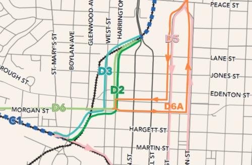
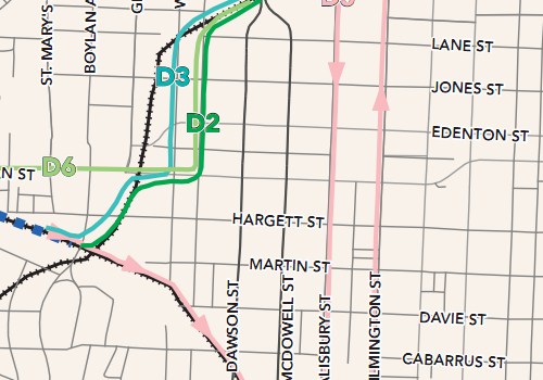
To continue my intro on this, take another step back to March 2011 where many alternatives for the downtown Raleigh light rail route were on the table. At this point, planners and citizens could weigh in on each plan. Around that time, there were four alternatives that were being seriously considered and have moved on to the next round. Those four alternatives, D2, D3, D5 and D6, are shown on this map. (click for larger)

It has been a couple of months now and decision time is coming up. The city, Triangle Transit and the PRTF all have opinions on this and the city council will narrow things down to a final winner with their approval. So far, of the four plans that moved forward earlier this year, we seem to have support behind just two plans. The alternative called “D6” looks tempting because it involves no elevated flyovers, a stop for the government district a short walk away and is projected to be the cheapest alternative. The second alternative with some backing is the PRTF recommended “D6A”, called that because it is a hybrid of two routes. Let’s add D6A to the map of alternatives.

If you can’t already tell, D6A was not on the list and now makes it five possible alternatives to choose from at this point. After some initial study, if deemed feasible then D6A gets a chance in the ring and we’ll go through a process of analyzing it against the other recommended alternatives.

Now here’s where you come in. There will be a public workshop and lecture about this plan and the others. Don’t comment on this blog post about your thoughts until after you have sent them in to the city for or against D6A. You can attend this lecture to hear more about the plan and drop some comments about it. Details are:

Monday August 1st, 2011
5:30pm – Workshop
7:00pm – Public hearing
Council chamber, Upchurch Government Complex
222 W. Hargett St.

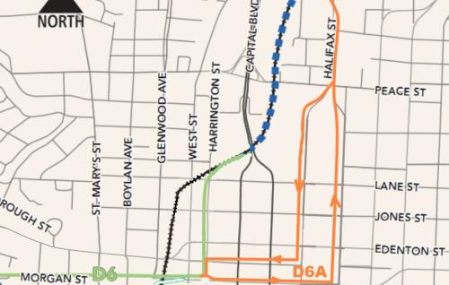
Now that the info is in front of you and I’ve passed along the details for the meeting, we can move on to some thoughts and discussion. It’s D6 versus D6A at this point. The D5, D2 and D3 alternatives are more expensive than D6, most likely because of the flyovers that need to be built. I also want to remind readers that the vehicles of choice here are three vehicle, 90 foot train cars for a 270 foot long train set. A typical city block is about 400 feet so the trains would take up half the length when rolling on downtown streets. Here’s a map of just the two alternatives for a more direct comparison.

I added the D6A route line on those maps so please feel free to send me a pat on the back for my talent with Paint.NET. Kidding, it’s horrible but hopefully it helps.

Light Rail in Raleigh, think of the big picture

To pick which route you like best, I think one has to start by looking at the whole system and the people on it. If you zoom out and look at this light rail line going from Cary through downtown and up to North Raleigh, you’ll see that the proposed stops are miles apart. This is how a light rail system works, moving people from one area of town to another. Larger than a light rail line, a high-speed train moves people between cities and going smaller, streetcars drop people off as often as every 400 feet. Now the tricky part of the downtown Raleigh light rail section is that it will cruise down the streets like a streetcar. Does this mean that it should behave like a streetcar when in downtown?

If your answer is yes, then I think D6A is your route of choice. This route offers more opportunities for bunched up stops and pedestrians can jump on and off more freely. The route penetrates downtown more than the D6 alternative, bringing a rider to the head of Fayetteville Street at the Capitol and right alongside the state government district. The rider catchment area is also greater, giving east Raleigh easier access to light rail.

On the flip side, if you believe that the light rail should drop people off in downtown and continue on it’s merry way down the streets then the D6 alternative is for you. Union Station should be a grand entrance to downtown and therefore riders can transfer to other modes of transit to get to where they are going. Looking at the big picture of the Raleigh light rail, this alternative also gets people in and out of downtown faster.

So each has its strengths but not without some weaknesses.

The weakness of D6, from my perspective, is that it doesn’t bring people into the core of downtown Raleigh. Riders from Cary and North Raleigh don’t have access to the middle of town and have a little more of an obstacle or another transfer to get to their final destination.

I’m not letting D6A off the hook though. The D6A route makes a 270 foot train act like a streetcar in a city grid where 30 foot streetcars roamed nicely over a hundred years ago. The streets haven’t changed much so fitting this behemoth onto downtown streets could be a bit tight. For reference, the modern streetcars in the city of Portland are 66 feet long, their MAX cars are 92 feet long and only operate as single vehicles.

So which one should Raleigh build?

In my opinion, the D6 route serves the entire city best if it makes a stop or two in downtown and does not try to act like a streetcar. The light rail is part of a multimodal transit network, one that has to compliment the other modes of travel. Downtown streets are best served by true streetcars, a network that should come much later in Raleigh’s transit planning future. To force the light rail line to act like one is risky and may not set a good foundation for future transit growth.

Building a Multimodal Network

So this is where I start to pitch my support for D6 over D6A. I had to think about it for awhile but I’m pretty set at this point.

I think those that are looking for that streetcar experience in D6A are losing sight of what a full transit network should be for Raleigh. The light rail line alone is not the answer to getting people to using transit. Along with the light rail, we’ll have upgraded bus routes, circulators and better accommodations for cyclists and pedestrians to get to and from transit stops and final destinations.

Transit, by nature, is multimodal so that is how everyone must think when imagining using a transit network that doesn’t exist yet. Riding will always involve, for 99.9% of people, a walk or bike ride to the nearest bus or rail stop, travel to another stop, then get off and ride or walk to their final destination. There may be one or two transfers, or connections as it’s called outside of this country, to ultimately get you to where you are going.

I feel D6 sets this possible network up in the future. Imagine a spiderweb of streetcar lines coming off the D6 line to move people around downtown and the surrounding neighborhoods. That would be possible, and the natural next step for Raleigh, if the light rail is successful in helping spur development around her stations.

How does D6A set up this future multimodal network when it tries to do it partly on its own? Think of the new obstacles in creating connections around a light rail line that has multiple stops in a congested downtown with narrow streets. You don’t get that natural ease of mode change with D6A and we may be setting ourselves up for future lines to run on top of each other, which isn’t an efficient way to run a transit network.

If you look at the 2030 Comprehensive Plan, the light rail line is for moving people between the planned growth nodes and to spur transit oriented development in those areas. I feel the best use of the light rail line is to move people between these nodes according to the plan, not within the nodes as D6A tries to do in the downtown piece.

One More That May Seal It For You

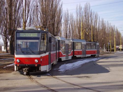
This one kind of hit me when I was riding the bus home and stared out at the NC State Capitol as we drove past it. Aesthetics are very important to some so let me remind you that the light rail cars will be electrified with overhead catenary wires, like the first picture in this post. D6A wants to run the trains right down Hillsborough Street from Salisbury to Harrington Street, a street with a nice view of the Capitol building. Now it’s no Fayetteville Street but long time readers or anyone following downtown may remember the Plensa fiasco of 2006. For a recap, jump to:

Collision of complex forces defeated plaza via newsobserver.com

Back then there were great concerns with the design of the plaza and how it would block the view down Fayetteville Street. If I recall correctly, the city even paid $10,000 to set up a mock up of the design so that they could see how it looked first. We ultimately couldn’t make a decision on it, making the process take so long that the $2.5 million gift was retracted and the project eventually died.

Anyway, that is in the past and may not be an issue this time but I swear people get really upset about overhead wires so maybe this is important to you.

Municipography, Food Trucks Debate Continues, Rezoning for Raleigh City Farm

Food Trucks

The food truck controversy continues with the Raleigh City Council passing the hot potato to the Law and Public Safety Committee for review. That committee’s next meeting is next week and their recommendation should go back to the city council for their meeting on August 2nd.

I felt like the tone of the meeting on this topic continues to be that of concern and fear. With the opportunity to create restrictions on this “nuisance”, the city council is clamping down on the food trucks without really thinking through it all.

The Law and Public Safety Committee is chaired by Mary-Ann Baldwin and also includes Councilors John Odom and Eugene Weeks. E-mail them your thoughts on the food trucks.

  • mary-ann.baldwin@raleighnc.gov
  • john.odom@raleighnc.gov
  • eugene.weeks@raleighnc.gov

Raleigh City Farm Rezoning

This rezoning request is for a property on East Franklin Street, here. Basically, it’s zoned for a shopping center and the rezoning is to remove any use of agricultural purposes on it. This is where the non-profit Raleigh City Farm wants to set up and the community seems to greatly support it.

The suggestion moves to the planning commission for review.

Parking Cleared For Outdoor Seating on Glenwood South, Cars Wimper While Driving By

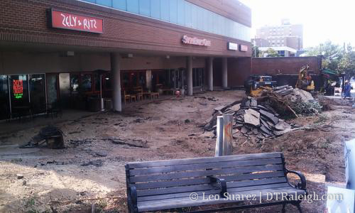
This is a small project that was first mentioned back in 2008. What a nice surprise to find this lot torn up as I walked up Glenwood yesterday. I asked one of the construction workers what they were working on and he confirmed that they were putting in a patio seating area for the restaurants in the building.

For those that can’t tell, this is the building in Glenwood South with Zely & Ritz, Sushi Blues, Taiphoon, and Bottega Hair Salon. Glenwood South is leading the charge on the outdoor seating options.

Bridge Replacement Projects On Capital Blvd

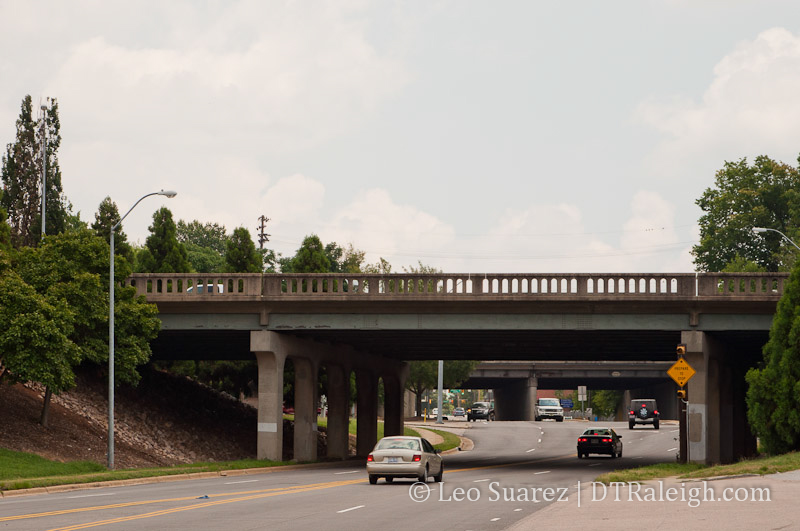
Capital Blvd is getting a little planning love from NCDOT. The bridge over Peace Street and the Wade Avenue flyover are in pretty bad shape. Both are on the books for an upgrade. From the NCDOT’s project page:

The bridge on Capital Boulevard over Peace Street (Bridge No. 227) was built in 1948 and has a sufficiency rating of 42.9 out of a possible 100. The bridge on Capital Boulevard at Wade Avenue was built in 1954, has a sufficiency rating of 34.1, and is posted with a weight limit. Both bridges are structurally deficient and functionally obsolete. While the existing bridges are still adequate to support traffic, they are nearing the end of their design lives and need to be replaced in a timely manner.

I’d like to thank the NCDOT for wanting to upgrade our “structurally deficient and functionally obsolete” infrastructure.

The project is in collaboration with the city’s Capital Blvd Corridor study which is still ongoing. This fall, expect a public workshop on the bridge replacement.

Capital Blvd Corridor Study via RaleighNC.gov

Municipography, Light Rail Through Downtown Raleigh

Recommendation from the Passenger Rail Task Force (PRTF)

From the agenda:

Triangle Transit Light Rail System

At their June 20, 2011 meeting, the Passenger Rail Task Force deliberated on alternatives for the proposed light rail system relative to downtown Raleigh. After discussing the item and reviewing data provided by City staff and by Triangle Transit, the Task Force voted 6-1 to recommend endorsing Alternate D6a, a hybrid alternative proposed by the Task Force during their deliberations. A complete explanation of the Task Force’s deliberations is included in the agenda packet.

Recommendation:
The City Council may wish to schedule a workshop to discuss the recommendations of the Passenger Rail Task Force in detail.

At the meeting yesterday, Will Allen of the Raleigh PRTF went through a brief presentation on the transit mode and route through downtown that they recommend. They agree with Triangle Transit’s preferred vehicle, that being “rail cars electrically powered by overhead wires”. Their route recommendation for the downtown Raleigh portion of the light rail piece is what they refer to as plan D6A.

Before we dive in, let’s be clear. This is a recommendation on Light Rail Transit, not high speed rail, whose drama series seems to be on hold for now. For a refresher on the latest light rail plans and where we last left this discussion, go ahead and jump back to March 2011’s “Light Rail in or over downtown Raleigh?

The post back in March talks about a few plans that were on the table for light rail through downtown. The D6A plan, the one recommended by the PRTF, was only mentioned lightly at the transit meetings that took place earlier this year. If you watch the video, the presentation recommends this plan:

The PRTF belives the D6a route through downtown Raleigh will best serve Raleigh citizens for the present and future by providing the best oppurtunities for ridership and economic development while ensuring safe transportation and minimizing impacts to traffic, urban design, noise, contextual planning, historic resources, and long term options for roadway and to connectivity improvements, all at a reasonable cost compared to other alternatives.


View D6A in a larger map

I threw together this Google map to show the proposed D6A route. In addition to recommending D6A, the PRTF also recommended the already talked about D6 plan but only if D6A was seen as too impractical.

Triangle Transit likes D6. The City of Raleigh likes D6 as well.

I did some searching and found this little gem of a pdf. “Memorandum: Issues Regarding Proposed Light Rail Alternatives in Downtown Raleigh” dated June 30, 2011. Eric Lamb, Manager of the Office of Transportation Planning sent this to our city manager, Russell Allen, and other interested peoples.

You can read as much or as little as you like but here are some highlights which I’ll quote.

Overview & Alternatives
….
There are several alternatives that TTA has presented to the task force and to the public with multiple options for traversing downtown. As a result of their deliberations, the task force chose to develop a hybrid alternative called D6A that was not previously considered or studied by TTA.”

D6A is introduced and described in text and hard to read black and white maps.

Value Capture & Redevelopment
….
The majority of land along the Salisbury/Wilmington corridor north of Union Square is owned and controlled by the State of North Carolina. It is unknown as to whether or not consideration of Alternatives D5 or D6A would induce the State to divest itself of these properties for the purposes of re-development.

An issue seen with running light rail through the government district is that it won’t encourage redevelopment because it is state owned land. Development from light rail is needed, to an extent, to help pay for the system.

Dawson/McDowell Corridor Conflicts
….
Triangle Transit anticipates operating train sets composed of up to three 90-foot vehicles, making each train set a maximum of 270 feet in length. An Average city block in downtown Raleigh is approximately 400 feet long. It is also anticipated that operating this system streetcar-style will occur in mixed traffic, i.e. it will not be within a dedicated lane exclusively for transit use. If queues or more than four to five passenger cars already exist for eastbound or westbound traffic at either Dawson or McDowell Streets, an approaching train would queue across the previous intersection while waiting for the traffic signal.

Basically, NCDOT is worried that the back end of a train will stretch into it’s US 70/401 corridors and block traffic. At peak hours, almost every 10 minutes you’ll have a train cross a road that sees between 40,000 and 50,000 vehicles.

Impacts to On Street Parking
….
Please note that another major obstacle to removing on-street parking may occur adjacent to the North Carolina General Assembly (NCGA). In 1998 the NCGA took control of these streets for the purpose of establishing exclusive use of on street parking for legislators and their staffs (see NCGS 120-32.1). Operating a light rail system along Salisbury and Wilmington may require the removal of this reserved parking and will ultimately require the permission of the Legislature as an encroachment on the legislative grounds.

Pretty self explanatory here. I’d love to sit it on this meeting if the city goes this route.

Cost Estimates

A summary of the system costs for each alternative is included below. Please note that TTA has not conducted any analysis of Alternate D6A and the cost estimates for this alternate have been extrapolated from costs for D5 and D6.

Table 2

I’m unable to properly copy Table 2 so I’l put it in list form below. Costs are in M, for Millions, B for Billions:

  • D2, Downtown segment cost $270M, total system cost $1.425B
  • D5, Downtown segment cost $435M, total system cost $1.590B
  • D6, Downtown segment cost $265M, total system cost $1.420B
  • D6A, Downtown segment cost $330-350M, total system cost $1.485-1.505B

Summary
….
The staff’s perspective is that this position does not appear to be directly supported by the data. Our analysis of existing and extrapolated data concludes that the hybrid Alternate D6A will likely cost more, will operate less efficiently, has potentially greater historic property impacts, and may not generate sufficiently higher ridership to warrant further consideration.

Well there it is. Lamb does recognize that the D2 and D6 alternates also have their own problems but claims they “appear to have fewer hurdles than Alternate D6A.”

As stated in the summary, the PRTF looked more at the “what” during their analysis where the city focused on the “how”. Any readers that are focused on the “when” may have to cheer on our neighbors in Durham County this fall.

Solar Projects In and Around Downtown

Examples of sustainability in Raleigh are becoming easier and easier to spot these days. In a city filled with different government bodies, solar projects, hybrid cars, and rain collection systems are just a few examples of the things that all the government players in Raleigh have or will have in the coming years. The city, and all the way up to the federal government, are taking on green projects in downtown Raleigh.

In my opinion, the City of Raleigh has done a fantastic job of not just preaching sustainability but practicing it themselves. The LED city initiative, the developing Climate/Energy Action Plan and a handful of new LEED certified buildings are ways that they are walking the walk. Did you even know that the city recently hosted classes on installing solar heating and cooling systems? We’re also on a nice map along with other major cities for having plug-in stations for electric cars.

The list of green projects in downtown Raleigh keeps getting longer and longer. Solar projects are the ones I wanted to highlight in this post. There are a few interesting solar projects happening in downtown Raleigh worth noting. They are tough to notice without flying over the rooftops and seeing them for yourselves so keep an eye out for these if you’re ever up high on a balcony in downtown.

Terry Sanford Federal Building


Solar array under construction in October 2010 via Downtown Raleigh Digs

The federal building over on New Bern Avenue is now covered with solar cells, as you can see from the picture above taken in October 2010. Here’s a little PR for you:

Working with the Region IV GSA project team, we implemented a 560kW design utilizing 59,000 square feet of previously unused roof space for the solar array. The generated solar power is fed to a utility scale inverter which supplies the power to the building, reducing the building’s annual grid load by over 17%. In addition to developing a system that optimized performance and minimized costs we utilized ARRA approved “Made-in-the-USA” component.

standardsolar.com

The $3 million project was part of the American Recovery and Reinvestment Act. Details about that spending are over at the GSA. This project will reduce the carbon dioxide count by 675 fewer tons each year.

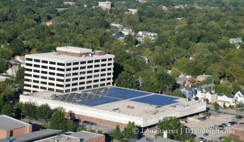
Raleigh Convention Center

Raleigh Convention Center by dtraleigh, on Flickr

In November 2010, the city shook hands with FLS Energry/Powerworks to allow them to set up some solar cells on the roof of the convention center. The deal is that FLS would lease the space from the city for them to set up their solar gear. The energy generated would be sold to Progress Duke Energy. This is a nice partnership as the installation comes at no cost to the City of Raleigh and we can buy the array at a later time if needed.

The convention center occupies a city block in downtown. 60% of the roof will be covered in solar cells producing about 725,000 kilowatt-hours of electricity and reducing carbon dioxide emissions by about 1300 tons, annually speaking of course.

If any readers have access to height, a window and a camera somewhere in downtown, photo submissions would be much appreciated to share with the community of the array on top of the convention center, which should be up there today.

Solid Waste Services Operations Center

It’s not exactly in downtown but this solar project is part of a new facility that will make clear some room. The City’s new Wilders Grove Solid Waste Services (SWS) Operations Center off New Bern Avenue just outside the beltline will replace the current headquarters that sits on Peace Street, at the site of the old Devereux Meadows Baseball Park. From the press release:

The City is planning a 50-kilowatt solar photovoltaic array at the administration building and a 25-kilowatt facility at a vehicle wash building at the Wilders Grove SWS Operations Center. These arrays are expected to provide a minimum of 12.5 percent of the two buildings’ energy use. The 50-kilowatt array will produce an estimated 69,055 kilowatt-hours of electricity per year, roughly equivalent to the annual energy use of five homes in North Carolina. The 25-kilowatt array is expected to produce an estimated 34,527 kilowatt-hours of electricity annually, which is equal to the yearly energy use of 2.5 homes in North Carolina.

Not as much solar collecting power as the previous two examples but the new building will seek a LEED platinum rating, the highest out there, and not the city’s first time achieving platinum.

I’m sure the list will grow over the years as this catches on. I hope to see this momentum continue.