Now that we’re into the spring season, outdoor seating during the warmer hours is in high demand. Downtown Raleigh actually has a plentiful amount of outdoor seating options with some doing it better than others. That’s for another post but here I wanted to highlight an interesting seating situation.
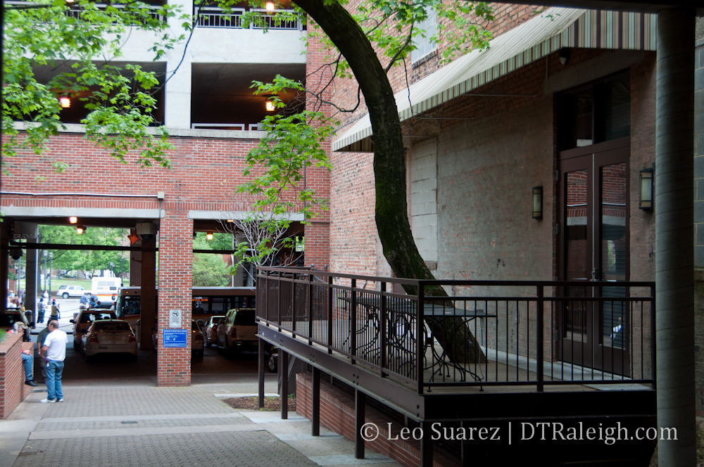
Take a look at the photo above. (click for larger) It shows the outdoor seating balcony of the Wilmoore Cafe located on Wilmington Street. The seating is slightly overlooking the walkway that connects the Moore Square bus station to Wilmington Street in the middle of the block. From what I hear and the times I’ve been by, very little, if any, people are actually using this outdoor seating.
So I’ll back up and admit that when the Wilmoore Cafe first opened, I thought that this balcony here would be great outdoor seating. I still do and in fact, there is a lot of potential for all that space behind the buildings of Wilmington Street and under the Moore Square parking deck. So when I heard that a lot of people don’t end up sitting out here I started to wonder.
The photo I have posted here is not during work hours so bear with me.
The balcony at first glance seems to have everything that a great outdoor seating space should have. It’s small and cozy. There’s a bit of separation between yourself and the walkway but not too much that you feel detached. The tree cover adds a hint of nature to the setting. The area is also not empty during work hours as people walk through here all the time so there’s plenty of people watching opportunities. People attract more people to any public space.
There’s something about this part of the station that I really enjoy. I walk through it all the time. The more complex nature of steps and walkways that are completely away from the street makes it feel urban. It’s a very different place within our city. So could this be a part of the reason that this great balcony for morning coffee drinkers isn’t working?
Outdoor seating within the core of downtown is dominated by sidewalk seating. The Raleigh Times, Capital Club 16, The Big Easy, Vic’s, Tir Na Nog, and many more restaurants just place the tables and chairs on the sidewalks and people flock. What is it about the sidewalk that works so well?
To me, I think sitting on the sidewalk puts you right in the middle of the traffic, the sidewalk traffic that is. The people watching when sitting on the sidewalk is so much more enjoyable than being inside. I also think that we’re all just in love with what is going on up and down the streets. The vehicle traffic provides that background noise that makes things more comfortable. Ever been to a party with the music turned off?
So back to the Wilmoore Cafe balcony and the photo at the beginning of this post. Could people not be sitting here because it’s simply not the sidewalk? Maybe it’s too far from the street? Or perhaps nobody knows about it?
The area has some flaws however and they are shown in the photo. You can see several cars parked right underneath the parking deck and pedestrians have to weave through them. There used to be a fountain here. Does anyone know what happened to it, why it was removed? The lighting is also that ugly amber that makes you feel like you are under a highway. I think it’s these little things that could make a big difference if re-thought.
Like I said, I think there is a lot of potential for a great public space inside this block that has the Moore Square bus station. However, it needs a people friendly touch so that visitors stop and visit rather than pass through. Some of these things, I hope to see as part of the Moore Square bus station upgrade that is upcoming in the next few years. That may create more cozy balconies and alcoves for us humans to stop and relax in.