Thanks to a few readers who found this aerial visualization of the Peace Street and Wade Avenue Bridge replacement project. NCDOT should start this project this summer.
For more on it, especially the Peace Street part, go here.
[UPDATE:5-26-16]
A raise of the glass goes out to Jim who made this overlay of projects on top of a screen grab from the video. Click for a larger view.
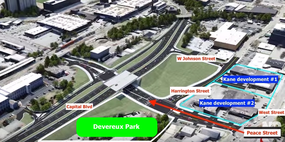
The Capital Boulevard aerial doesn’t consider the new Williams and Kane joint projects but with the announcement posted earlier this week and the Smokey Hollow LLC purchase nearby you can see some of the possible development outcomes of the new square loop.
A Johnson Street connection from Glenwood to Capital would make for a great grid of streets around the planned developments and hopefully ones in the future. Johnson at Capital could be a major entrance to Glenwood South for those coming from North Raleigh.
With the Devereux Meadow Park on one-side of Peace, the opposite side has to come at a premium due to how much traffic is funneled down Peace Street. With Peace being practically the only east-west artery in this area, I imagine the vehicle, bike, and ped counts will continue to be higher than other streets.
Comments
Comments are disabled here. That's because we're all hanging out on the DTRaleigh Community, an online forum for passionate fans of the Oak City.
Unfortunately this reconfiguration makes access to Peace when heading south on Capital really tedious, and again getting onto southbound Capital from Peace. The intersection of Johnson and Harrington could be a backed-up mess.
After studying this more, I actually really hate how they’ve moved the exit for southbound Capital. What traffic engineer approved forcing all of the traffic between Peace and Capital onto 2-lane side streets with what will likely be a stop sign inbetween?
People will probably use Harrington or West to go south. I don’t see it being a huge issue.
The city wants to use the northwest corner of the intersection as a park so NCDOT decided to go with this intersection configuration. It’s called an urban square loop – utilizing existing streets as “exit ramps” from one main street to another.
@MH (my initials interestingly). I lived at Peace/Glenwood and commuted on foot to east Peace for several years. I can say without a doubt the two most highly used movements at this interchange are southbound Capital to east Peace in the mornings and the reverse in the afternoon. The morning commute is a horrible left turn onto Peace with…get this…no traffic light! Talk about backing up…the current setup backs up onto Capital regularly. The new setup will enable three right turns to achieve the same result. Even if these are only stop signs, this is a huge improvement on the current situation. The afternoon commute will not be impacted much either way getting on to Capital, but we will get a much more pedestrian friendly layout and a smoother pass through the area for through-Capital traffic overhead. Any movement from Peace to southbound Capital is minimal at best because there are so many easier options further south in the street grid for heading south. I’ve lived all over the City for 29 years, 26 as a driving adult, and this is absolutely the most untenable intersection layout in the city as it currently exists. The changes are not just an improvement on all fronts but major improvements. I was originally on board with the fundamental change of dropping Capital down to an at-grade interchange…something Leo campaigned for quite vigorously I believe…but am fairly satisfied that if it must be an interchange, this is a good arrangement.
Is the initial intersection shown the current bridge at Fairview that is also being redone?
Matt, that is Wade. That rendering shows it almost exactly as it is currently configured. I didn’t hear this announced or anything, but I don’t see any indication that Fairview is still part of the project. My gut says that bridge might just get eliminated entirely at some point…but that is just a musing…
Check out the latest update to this post with a screen capture from the video and an upcoming developments overlay.
Thanks for that update Leo! Looking at the development overlay and thinking about the traffic flow, it would seem to me that Johnson needs and “always goes” right turn lane onto Harrington northbound to right again on Peace. This might allay some of the concerns of a traffic back up. A second, more traditional right turn lane could be employed for traffic that will eventually turn left at Peace toward Glenwood.
Does anyone know what’s planned for the land bounded by Johnson, Harrington, Peace, Capital? Certainly the plan isn’t to leave a large undeveloped grassy lot as depicted in the view?
The Smoky Hollow/Kane-Williams development for the other post takes up both sites #1 & 2 shown in the update.
No plans so far for the land inside the square loop, but it will be developable.
Maybe Kane is already in talks with the DOT to strike a deal to connect the two portions of Johnson Street. It would be unfortunate to leave the grid as is. The reconfiguration of the Capital Blvd ramps will take this area from a sleepy corner to one of the most visible.
I would be shocked if Kane/DOT/Raleigh have not already discussed connecting Johnson Street as part of their project. I wonder what could be developed inside the square loop with Johnson/Harrington being a part of the “exit”.
@Pierre Tong….with both Johnson and Harrington being secondary roads that are both two ways, it would seem to me that the bounded property would be easy to develop. Given that more development in Glenwood South will encourage more traffic as a destination in the city, I would like to see that land become a project with a substantial parking garage included in it. This way visitors to Glenwood South can take Capital to Johnson and immediately park. This will free up traffic in the district itself and increase emphasis on the pedestrian experience. Of course, this property can support more than just a parking garage. The new code allows up to 12 floors (hence the height of Kane’s project) and I can imagine something like this…Develop the lowest grade level along Peace with walkable businesses in support of the neighborhood. I’d love to see a new Finch’s be part of that scenario but that’s just me reminiscing. On top of that first level can be a parking garage accessed at the higher point on grade from Johnson Street with its exit onto Peace. The parking deck can take up the lower floors where the noise of Capital Blvd won’t bother the parked cars. The remainder of the 11 allowable floors can be split 6 to 5 with the top five floors containing a hotel, condos, entertainment or offices. Offices might make the most sense since the parking for them during the day could double as parking for district goers in the evenings and weekends. Creating an evening and weekend parking revenue stream for the landlord might encourage this sort of development.
Stew I think that lot is where the Cleaners/Watkins/Furniture buildings are, and will remain. Probably just left them off the rendering because they aren’t pretty. Though I know of at least one influential artist downtown who envisions the Watkins space as the perfect bar…
John, I dig the ideas…make it so! Can I make my version use the existing buildings I just mentioned as the Peace street fronting businesses? The dry cleaners is quite a nice old warehouse and would support things like retro furniture stores, breweries, or other unique concepts that require aged character…
Mark, I’d like to see how those buildings actually layout vis-a-vis the new bridge and the extension of Harrington.
For the new bridge, it appears as though the current location of the southbound lane of Capital will be the location of the future northbound lane and that the Finch’s property is the new location of the future southbound lane.
The weirdness that is the current Peace Street widening in front of the former Finch’s and the triplicate of buildings to its west, including the cleaners, is unresolved for me but it would seem that these buildings will not be sidewalk adjacent in the new plan. For those who might not realize, Peace is really wide in this stretch and its southern extent is nothing more than a place for head-on parking in what appears to actually be the street itself. Go check it out if interested.
As for saving the buildings, propping up and reusing facades within the context of a new building is something that is done in Miami all the time. I don’t see why it couldn’t be done in Raleigh as well. However, one would be hard pressed to generate enthusiasm for those buildings as they have little architectural significance. That said, I would be interested in seeing what could come of it.
The extension of W. Johnson Street to connect Harrington and West Street has been part of the streetscape plans for years, well before Kane put is flag on the property. My understanding is the Kane’s plans will now accelerate the timing of that connection.
Image the new “Glenwood South Exit” on south and northbound Capital Blvd / Dawson Street.
Say goodbye to Finch’s. No room for anything remotely interesting/authentic in “New Raleigh.”
For those who have not seen these before, I apologize in advance for wasting hours of your time. http://dc.lib.unc.edu/cdm/compoundobject/collection/ncmaps/id/9084/rec/6
This is the link to a 1914 Raleigh Sanborn Insurance map. They show details about every road and building in the City, in this case, in 1914. There are other years for Raleigh as well, and many Towns and Cities covered throughout the State. I linked this one because it shows two relevant items…Johnson Street used to “connect” in this area, but was offset at West St. Also, Peace was offset at Dawson, and that alignment is preserved in the sidewalk alignment and building orientation of the three buildings facing Peace (Watkins Shoe shop et al). Dawson is of course now gone, replaced by Capital all the way to Lane. Enjoy!