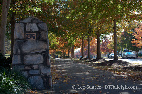
Chavis Way, entrance to the greenway off the 500 block of East Martin Street.
I just did some online searching for information regarding the Raleigh Greenway system. It’s pretty sad that there isn’t an informative, well designed page dedicated to educating people on the expansive network of trails that go all over Raleigh. If you know of one, PLEASE share it.
The city’s website has only a small blurb about it here and you can download pdf maps of the parks and trails too. (links below) The maps are not up to date and the enormous file is cumbersome to navigate without a gigantic, high-resolution monitor.
Capital Area Greenway System Map (via raleighnc.gov)
Park And Greenway System Map (via raleighnc.gov)
The best resource out there is a real map of the network which you should be able to pick up at any bike shop around town. The adventurous will learn by just jumping onto the greenways themselves and picking them up as you go.
How does Downtown Raleigh fit into this network of trails? Looking at a portion of the map below, we get…. (click for a larger view)
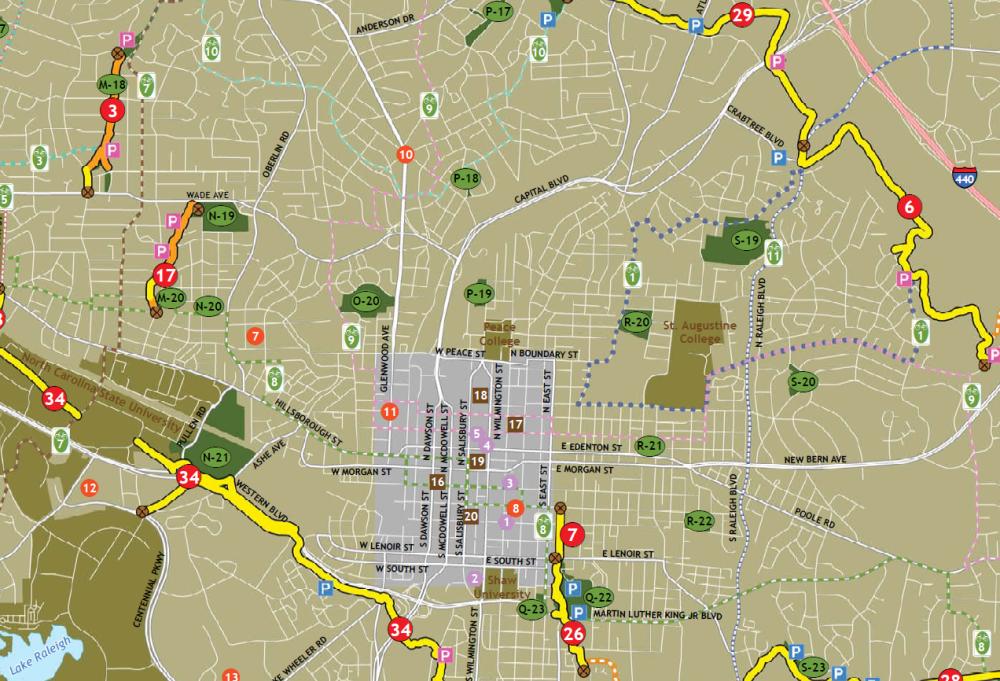
Great Connections
The southern portion of downtown, highlighted in purple in the center, has pretty good access to the greenway trails running along southern Raleigh. If you work your way into Boylan Heights, West of downtown, you can get to the trails that run along Western Blvd very easily, marked by #34 on the map. This is a perfect way to get to Centennial Campus and the rest of NC State University without battling car traffic.
Trail #7 begins on Martin Street to the east of downtown. This trail will easily get you to many different parts of southeast Raleigh. It is possible to use this trail to get to the NC State Farmer’s Market while heading east weaves through secluded woods and wetlands.
But what about going north?
The long trail that runs along the northern arc just inside I-440 is a beautiful path to ride or walk on. I’ve ridden on it many times from one end all the way to Shelley Lake and back. I highly recommend getting out there and seeing it. Here’s the trail: (click for larger)
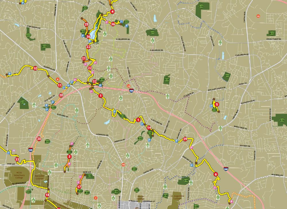
This is the trail to get to if you want to ride out to North Raleigh. I went shopping once at Crabtree Mall, getting there by bike on the greenways. Also, North Hills is a quick detour on Lassiter Mills Road but I’ve never tried it.
Conversely to the southern trails of Raleigh, the northern trails are harder to get to and is a little intimidating to the average rider. That may change in the future as a few ideas are being thrown around to run a greenway right through the middle of downtown.
Downtown trails for more connectivity
Right now, there are two developments that Raleigh Connoisseurs like yourselves should be aware of; the South West Street extension study and the Capital Blvd corridor study. We will get into the specifics of those topics, especially the West Street extension because I haven’t mentioned it here on RalCon as of today, at a later date but for right now let’s look at where the word ‘Greenway’ comes into play here.
Prerequisite Reading: Union Station – West Street Extension Alternatives.pdf (via raleighnc.gov)
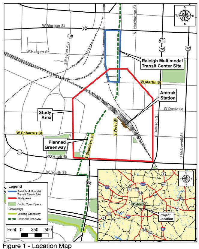
In short, this document has some great details on how planners are thinking about having West Street, which currently dead ends at the railroad tracks after crossing Martin Street, connect to W. Cabarrus Street to support the future Union Station. A planned greenway is drawn up, running along West Street and ending at the current trail near Lake Wheeler and South Saunders Street. Picture below.
This portion will most likely be much more urban then the other trails around the city and the documents suggests that the greenway will be implemented with wider, multi-use sidewalks.
The Capital Blvd corridor study has talks of a possible greenway as part of the new additions to that area. Jim Belt of the Raleigh DLA wrote up a great review of the recent workshop and mentions that a greenway route is on the table. This map shows what a connection from the existing trail on Raleigh Blvd to downtown Raleigh could look like. The trail ends near the intersection of West and Peace Street but hopefully can be shot straight down West Street and into Union Station.
Putting the pieces together
If you add a greenway trail along the Capital Blvd corridor and another along the West Street extension, we now have penetrated downtown Raleigh with a trail and the rest of the network is easily accessible in all directions. Running it right by Union Station is a huge plus for the future of alternative transit around Raleigh as well.
Related Links:
Capital Blvd Corridor Study: RaleighNC.gov
Comments
Comments are disabled here. That's because we're all hanging out on the DTRaleigh Community, an online forum for passionate fans of the Oak City.
[…] Downtown Greenways – now and in the future […]
Great piece Leo. As of now, this is probably the best document on the Raleigh Greenway Trail system on the web.
Great post Leo. Readers appreciate all the research that goes into writing a post like this. I noticed that the greenways north of Downtown have gotten new signage recently, e.g. Crabtree Trail. I’m also aware that the Raleigh Parks & Rec department is painfully aware of their website shortcomings for easy to use and up to date maps. I’ll forward this to them so they can hear it again.
I’m really excited for the Greenway going all the way up to North Raleigh on the Neuse. Hopefully they’ll connect that to maybe the Walnut creek section that runs to Western Blvd.
I rode from Fred Fletcher to Mt Vernon and Six Forks, and most of it I could do on the Greeway.
The next step should be linking the N,E,W,S together at a single or multi points within the inner core stretching outward.
Well done on this article. I would love some good connections out of downtown to the rest of the city. The capital blvd greenway would be nice, and it would encourage people to use it and try getting places that they maybe didn’t know they could of, without a car. The thing is that one can easily get to that same location safely from downtown through Oakwood and Woodcrest.
The real problem is getting past there. There is not a “safe feeling” passage across the beltline from Lassiter Mill to all the way on the south side on State St. (10 miles of the beltline!), which is not the safest for other reasons. Sunnybrook is not too bad, but many would not want to travel on a bike on that road. Raleigh Blvd. is listed as a bike route, but most would not want to ride on a 45 mph five lane ride. One day I wanted to ride out to Oakview County Park and couldn’t believe that I had no choice, but to use Poole Rd.
The city needs to take a look at their easements that pass under the beltline and try and create some passageways to connect the whole city. Huge neighborhoods like Brentwood and Timberlake, along with anything south and east are left abandoned from using trails because of the great wall created by the beltline..
http://www.gettoknowapark.org/
I recently discovered http://www.raleighpedbikemap.com/
It does a good job of showing greenway and bike options as well as planned updates.
Very interesting article.
“The city needs to take a look at their easements that pass under the beltline and try and create some passageways to connect the whole city.” From Ken Metzger
I agree Ken. If possible, the city needs to take advantage of these options. Also, I am not sure of the legal issues (DOT ownership, liability), but I have walked along the embankments above portions of I40. They are above the traffic (some are 40 to 50 feet above traffic) and there are already paths from when they were constructed. These could easily be used almost as is. With minimal effort, long distances of non paved paths could be incorporated into the greenway system.