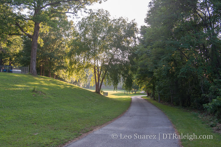
The Rocky Branch Greenway in Dorothea Dix Park.
Plans are underway for the Rosengarten Greenway, a path starting from West Cabarrus Street and ending at the Rocky Branch Greenway on South Saunders Street. While neighbors in Boylan Heights and Rosengarten Park work with the city on a final plan, a walk along the potential route got me thinking about some kind of connection from downtown to the future Dix Park.
We’ll get to the Rosengarten Park greenway soon but the topic of connecting downtown Raleigh to Dix Park is laced in opinions. Of course, you are about to get one more but that’s why you come to this blog now isn’t it? ;)
I say it a lot and I’ll repeat it numerous times but debates on walking and biking routes hold very little without actually walking the areas first. Driving is of course the easiest way to get back and forth but a tight-knit urban fabric between Dix and downtown could be a huge boost to living and working here.
At this time, I’m not convinced that walking back and forth is for the casual but rather for the dedicated with time on their hands. I’m not saying it’s necessarily difficult but it’s just far enough to not be convenient and the elevation change makes it feel further than it is on a map.
For sake of argument, I’m going to define the entrance to Dix Park as the “intersection” of Western Boulevard and Boylan Avenue. For this blog post, that is the destination we’ll take a look at. Keep in mind, once you are there, you still need to hoof it up the hills into the park itself to whatever future spot you want to get to.
Without diving into the details, it’s about a 15-20 minute walk from anywhere in the Warehouse District to the entrance. We’re talking 25-30 minutes a little further out, say the Capitol building or Glenwood South. In my book, that puts the walk to Dix in the recreation category of my time. Runners might make it a frequent part of their day though.
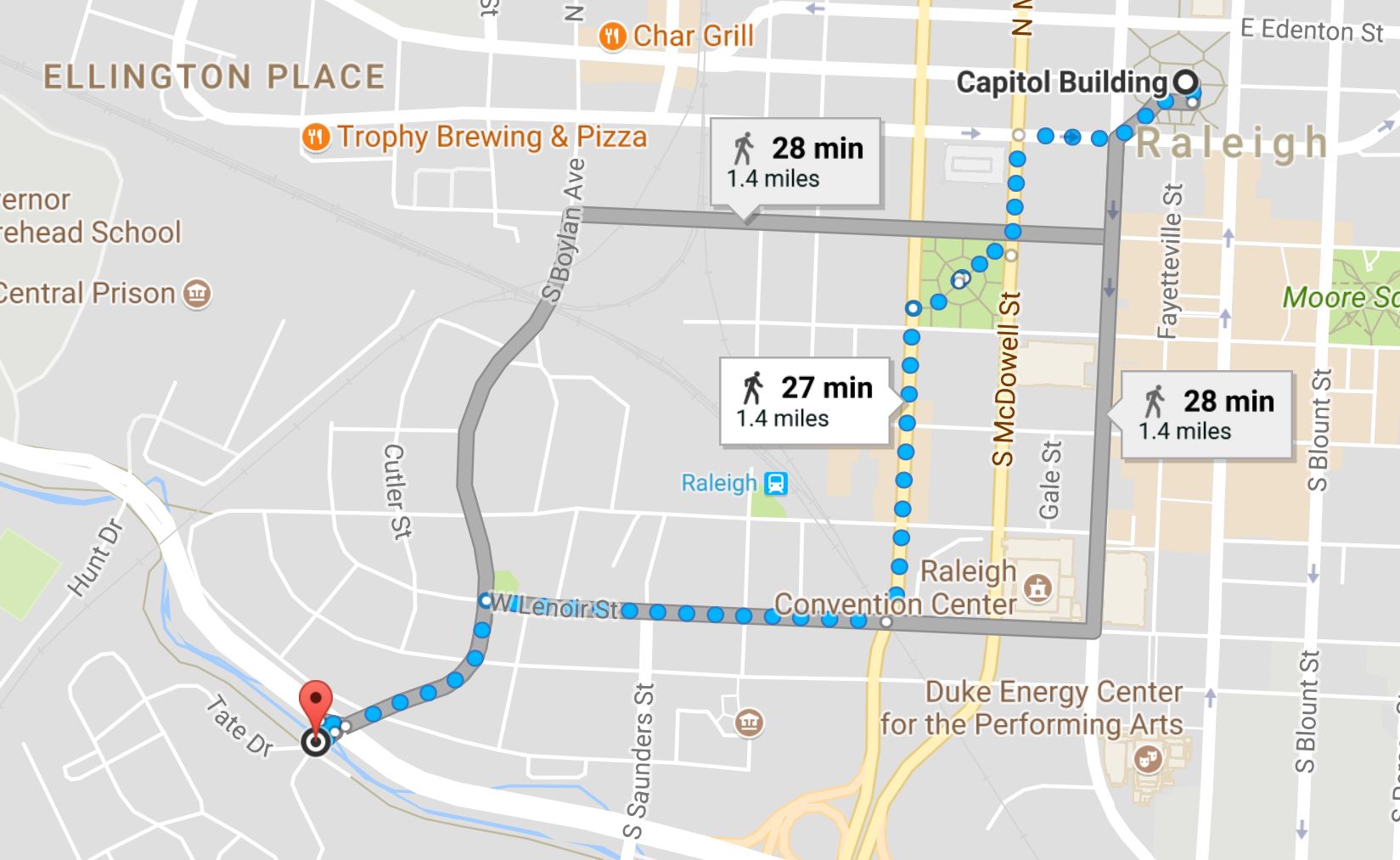
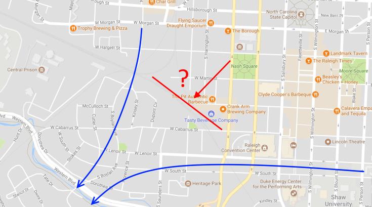
Walking routes from NC Capitol to Dix Park entrance. It’s about 30 minutes from the Capitol to the entrance of Dix Park.
That’s no problem for residents but I don’t see visitors to downtown, staying in the hotels for a visit whether it be for a convention or family event, taking a casual walk out there. I’m not sure it’s enough to justify any special walking paths anyway.
It’s also not very flat.
To the south of downtown is the Rocky Branch creek. Parts of downtown slope downward towards it, dropping almost 80 or 90 feet in elevation. You’ll feel those hills on a warm day.
I’ll leave the walking piece of this to the small group of dedicated peds. It’s the cycling route I’m interested in. With a Bike Share system coming next year, cycling out to Dix would be a great to-do when staying in downtown. Cycling would be much more pleasant compared to that previously mentioned walk and drops the time down to 10 minutes on average.
The Rosengarten Greenway
The Rosengarten Greenway likes to be thrown in to the conversation of connecting downtown to Dix. You can dive into the project on the city’s website.
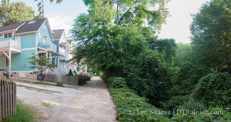
Rosengarten Alley, June 2017.
Starting at Cabarrus Street at Rosengarten Alley, the goal is to connect a greenway to the current Rocky Branch trail. (which is south of Western Boulevard) In the past, (2009ish) a more lofty plan existed but with new developments taking place since then the path has been modified some. Below is what we have from the past plan and the latest from the city’s website.
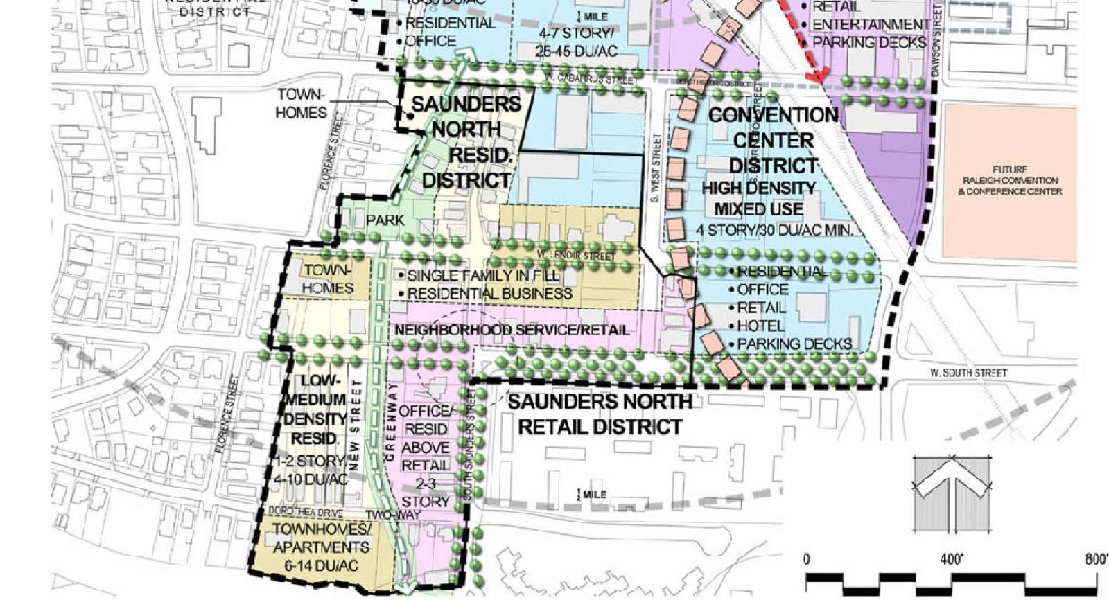
Downtown West Gateway Comprehensive Plan Chapter – City of Raleigh
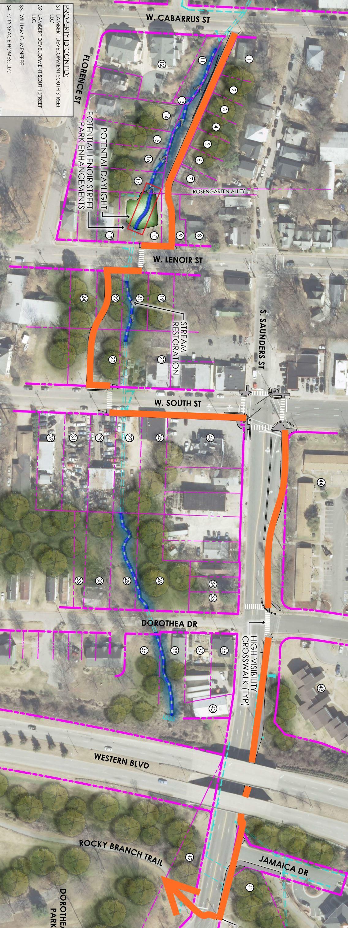
Rosengarten Greenway plan, 2017. Originally in gray, I’ve colored it orange so it can be followed easier. Click for larger, full path map.
The latest plan is a little piecemeal, sending greenway riders on a lot of sidewalks rather than dedicated paths. When I walked the proposed route, it was pretty scenic with an overgrown stream going north/south into and then just turned into regular sidewalks.
Whatever “controversy” there is around this path, I can’t see it. It seems like a normal, everyday path to me.
It feels like standard operating procedure here from the city. If there’s an opportunity to put a greenway along a stream, then they will plan it. I think people are getting a little to hung up on the downtown to Dix connection and this greenway is getting thrown into the mix when it really shouldn’t.
The downtown to Dix connection has to be on the streets.
Bike to Dix
Dix presents a perfect use case for bike share. Steering riders easily between downtown and the park could create a nice downtown to-do for anyone in town.
[For an update on Raleigh Bike Share, hear episode 19 of Inbound Raleigh, a podcast about transit and transportation in Raleigh.]
From Glenwood South and parts of Hillsborough Street, the route is mostly obvious. (the Boylan Avenue downhill speed run)
The two-way conversion of Lenoir and South Street makes it easy from eastern downtown.
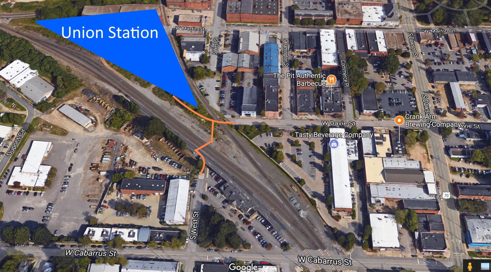
It’s the warehouse district that is tricky because of the separation around the tracks at the depot. This is where, I feel, the West Street connection was right-on with creating critical connections in the southwest side of town.
Mentioned in this 2013 post, there were plans to tunnel West Street underneath the tracks in the depot and connect the street to itself.
I haven’t seen plans for the tunnel in 2017 but I do see West Street being a pretty great street for connecting the Rosengarten Park area to the north. While the tracks are active, I imagine it possible for an at-grade railroad crossing for pedestrians and bicycles. Proper fencing and safety gates would be needed to divert bike/ped traffic from around Union Station to West Street south of the tracks.
This would be much cheaper than the tunnel option and examples of this exist in other cities. It would take coordination between the city and the state to get this done. Here’s a rough idea of what it could look like on a map.
The view from West Street just calls to be connected. Imagine riding a bike back from Dix and be greeted with this view.
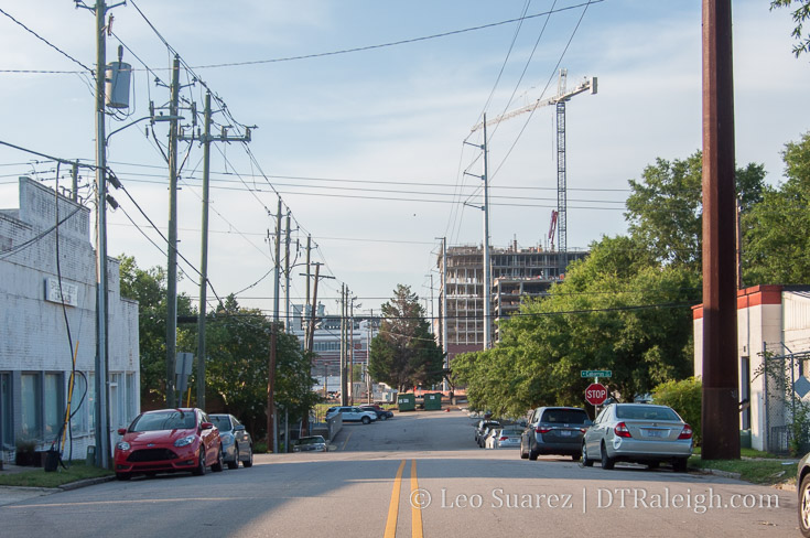
South West Street, June 2017. The Dillon could greet riders and pedestrians here as they come back from Dix.
Southwest downtown Raleigh is becoming a blend of neighborhood mixed-use with retail and residential. Vehicle traffic is slow and vehicle counts are low that the street space can be used for other modes of travel than a car. I’d really like to see rental bikes zipping through that area in the years to come.
Comments
Comments are disabled here. That's because we're all hanging out on the DTRaleigh Community, an online forum for passionate fans of the Oak City.
As someone who bikes this area, I don’t see a huge benefit from this piecemeal path and don’t think it will make that area much more bikeable than it already is. Considering S Saunders and Florence st. between Cabarrus and Lenoir are already very pedestrian friendly, pretty streets to bike with very limited automobile traffic, and the alley between Lenoir and South is already bikeable, I would rather see this money and planning energy being spent on a greenway along Lake Wheeler around the perimeter of Dix connecting the Rocky Branch trail to the 2 park entrances along Lake Wheeler, and the farmers’ market. I access this area from my home on the outside of 440 on Lake Wheeler. I bike down the 6′ sidewalk to Centennial Parkway, cross the busy intersection there, and then trudge up and down the blind hill of L.Wheeler with cars flying by. As far as I’m aware there is no plan to add sidewalk/greenway along Lake Wheeler as it will probably be included in the Dix master plan and be built in a far off year.
Rosengarten path controversy is very justified. Crossing street intersections 7 times in a half mile stretch is counterintuitive to the purpose of a greenway. You can cross intersections only 5 times by staying on sidewalk. Very disappointed to see city planners skimp on this.
other than extremely localized neighborhood walking, the rosengarten path isn’t much use and thats ok. bikes and other uses can use streets and sidewalks much more efficiently. the path can be used if you want to meander along the creek and it satisfies that end. seems okay to me.
Yes, it does satisfy a creek walking experience. I love creek restoration projects and think Raleigh needs to daylight and clean the many beautiful rocky creeks that it has. I.e. Totally looking forward to Devereux Meadows.
But as far as connecting Dix park to downtown and the residential areas just south of 440 (my neighborhood et. al.) And more broadly improving the connectivity of the city, this project is inconsequential IMO and could be better utilized elsewhere, like bridging West Street together per the blog post. Although I’ve heard getting railroads to cooperate on an at grade pedestrian crossing is near impossible.
Anyways, If it’s going to happen I hope they get it done quickly and move on to something that will offer more utility to visitors and residents.
As an avid biker and user of current greenways, my philosophy is the less street crossings, the better (and safer). I realize the street grid in DT is at odds with this, but anyway, here’s my idea:
Start the greenway at Boylan Bridge (which has pedestrian-ready sidewalks), cross the bridge southward, turn west on Mountford toward the tracks, and parallel a well-lit greenway with the railroad toward Dix? Either cross the tracks via the existing Mountford bridge-to-nowhere and ramp down to be at-grade with the tracks, or ramp down short of the bridge to parallel on the east side of the tracks. At Western, ramp down again to hook up with the existing Rocky Branch Trail @ the terminus of Cabarrus St. At that point, bikers could either ride east on Dorothea Dr. or west to cross Western via Hunt Dr. (Although a pedestrian bridge parallel to the RR bridge to Dix would be ideal!!!).
Anyway, using Boylan Bridge as the jumping-off point would connect the Glenwood South people via Boylan and would connect the DT/Warehouse people via Hargett.
I realize there are issues with RR easements, so maybe this would never work, but it just seems like there are way too many property owners to please with the Rosengarten plan; cutting through different properties, crossing several streets, etc. just seems “choppy” to me.
I like the idea of following the RR. An alternative could be to follow the tracks SE from Union Station to a shared use path or two-way protected bike lane along Dawson. From there the path could continue around Heritage Park to connect to S. Saunders near the Western Avenue Bridge and the Rocky Branch Trail. A path or trail of some sort along Lake Wheeler Road seems like a no-brainer as well.
While I agree that connecting West St. should be the highest priority of funding for the area to make Dix more accessible to the public, I am not holding my breath for it to happen. The RR is more like to close more streets than to open a new one. They already want to close Jones and didn’t they also include Hargett on their hit list?
If they close Hargett, it will really isolate Boylan Heights and further reduce their traffic in conjunction with the moving of the train station to the other side of the tracks.
It would seem to me that Boylan ought to be the path from the west side of DT to Dix for bikes and pedestrians.
@Tico, how did you get 7 crossings? From Cabarrus to Rocky Branch Greenway I only count 4. It’s only 3 if the path were to go along West Street and connect to the Saunders Greenway, so that seems like the safest and most logical option to me. That’s also much more direct. A greenway along South Street in front of Heritage Park could be a nice DT to Dix connector. Although, there’s a bike there now so it’s not really needed.
@carey, looking at Leo’s graphic I counted 7 crossings:
1.Cabarrus
2.Lenoir
3.South
4.Saunders
5.Dorothea
6.Jamaica
7.Saunders again
Its actually only 4 crossings if you’d stay on sidewalk as you’d eliminate the saunders double cross & Jamaica drive
TBJ has an article on the future of the Sir Walter Apts. (It’s free). http://www.bizjournals.com/triangle/news/2017/06/20/investor-who-wants-to-buy-historic-sir-walter.html
Looks like Charlotte.. is getting yet another taller building.. 35 stories. Must be nice..
Who knows, maybe the new City Hall building/complex will offer a tall building?
Robert , the last rumor that I heard was something around 20 stories ! This was 1 year ago !
Ah yes, the Napoleonic Complex about tall buildings is sure to show up in every thread…
@Mark.. ah yes… soccer.. soccer.. soccer.. zzzzz
Debating the merits (laced with some preference and opinion too of course) of things is pertinent and constructive. Being a fanboy of one thing and an anti-fanboy of another just makes you a hypocrite.
Back on topic; Can we redo Western Blvd? I think it’s a huge problem. Historically MLK was Smithfield Road. That could have been paired with Dorthea (Historcally Boylan Drive, and Cannon St which once punched through downtown along Kinsey and on to Worth), all the way from say Boylan Ave or Florence to Rock Quarry. Alas, what to do now though…? I think replacing the whole interchange of MLK/Western/Saunders with street grid would greatly improve downtown’s connection to Dorthea Dix. But just saying that is a huge simplification…wetlands, maintaining the Saunders primary arterial capacity and such all must be dealt with. But I am dismayed that this interchange even exists and will never be discussed for removal.
Lol, so salty.
@Dwight, You probably saw the N&O article a few days ago. The council wants to demolish all of the city hall plaza and build more than 400K square feet of office space, plus retail. They say they want to build enough space to grow into over time, so if we’re talking about a 30+ timeframe, that could easily be 700K + worth of total space. Any excess space would be leased to commercial users until the city needs it. But, like you said, we’ve heard this before…
Whats the latest on the N&O site?
I forgot to add it to the article, just did it now, but if you want to know more about Raleigh Bike Share, make sure to listen to this interview on Inbound Raleigh.
http://inboundraleigh.com/2017/05/31/ep-19-bikeshare/
Everyone talking about either building a new bike path in the existing RR right-of-way or adding an at-grade bike/ped crossing should take a deep breath and start on new ideas. The railroads are dead-set against this kind of thing and I’d bet my house it’d never happen.
Ever wonder why there’s no sidewalk across Hargett at the tracks? That’s because the railroad doesn’t have to build them and doesn’t ever want to encourage people to walk there. At that location they can’t stop people but that doesn’t mean they have to make it easy. So that’s a big enough issue for them, forget building anything else.
The railroads hate at-grade crossings for cars (as someone pointed out previously) so why in the world would they want people walking to cross. Plus they tightly hold on to their right-of-way for future expansion (When in the future? Who knows, could be 70 years) and they’d have to give or sell it to the city for that to happen.
I’d like this to work out just as much as the next cyclist, but using or crossing the railroad land should be dumped as an idea. The only way across are current crossings, tunneling under or bridging over.
This may be true for the private railroad corridors but not the NCRR. I find changes to the NCRR happen more frequently than the CSX or NS corridors. The state owns the area around west st so there is hope.
@DBDowntowner I think there’s a misunderstanding about my post. At no point do I think there should–or could–be an at-grade crossing or interference with the RR right-of-way. My thoughts were to parallel the RR just adjacent to their right-of-way. Either using the Mountford bridge to get over to the west side of the tracks (between prison and tracks) or paralleling on the east side. When I said “at-grade” in my previous post, I was referring to ramping the greenway down from Mountford to the level of the tracks so it wouldn’t be an elevated path…but still staying clear of their right-of-way.
It just seems to me that finding space immediately outside of RR right-of-way makes more sense than cutting through a bunch of back yards like Ferris Bueller.
http://www.americantrails.org/photoGalleries/cool/5-Rails-with-trails-photos.html
@Evan BINGO!
@Leo, there’s hope but I’m still skeptical. While NCRR is a “public” company (technically they’re private but the only shareholder is the State of NC) they’re still beholden to the contracts they have with the freight co’s that use their tracks as well as a myriad of other things that get in the way of them being a public entity as we usually think of it. So hope, but be cautious. Also, which properties around West St. are you referring to that the state owns? I looked on iMaps and didn’t see any.
@Will I see what you mean but there’s no space between the RR right-of-way and the private homes/studios in Boylan Heights. The RR owns ~50ft on either side of the tracks. For example, there are even some buildings in Boylan Heights (like the pottery studio or whatever it is) that are partially over the property line and in the RR right-of-way. That’s not unique to this part of town but just shows how crowded this space is. That is, unless you’d want the state to cede some of it’s property on the opposite side of the tracks – that’d make for some interesting views from the trail! :-)