
I spent some time this week with a survey from the city about possible plans to reconfigure North West Street between Peace Street and Wade Avenue that could accommodate bike lanes, walking paths, and a different parking layout. If that excites you, jump right on over to that survey here to let them know what you think. If I still got you, I wanted to revisit the plans for more bicycle infrastructure along West Street, how it’s going, and what we might expect in the future.
I’m not entirely clear on the origins but I think I have it right that the Downtown Plan from 2015 (pdf link) has the following:
- MA-10 Implement pedestrian and bicycle improvements along Person, Blount, and Peace Streets to connect downtown to planned greenway connectors along Pigeon House Branch and Capital Boulevard.
- MA-11 Prioritize West Street as a north-south greenway connector that will eventually connect to greenways north and south of downtown.
- MA-12 Study creating a cycle track along West Street north-south from future park-to-park.
The following year, 2016, sees the BikeRaleigh Plan being approved and it references the 2015 Downtown Plan for a couple of projects in the downtown area. This plan highlights West Street, among others, as a key connector of things and places humans want to go to. In other words, West Street is a good walking and biking connector to Dix Park through Downtown and into Five Points. The graphic below, lifted from the downtown plan, calls it the Dix-Devereux Greenway Connector.
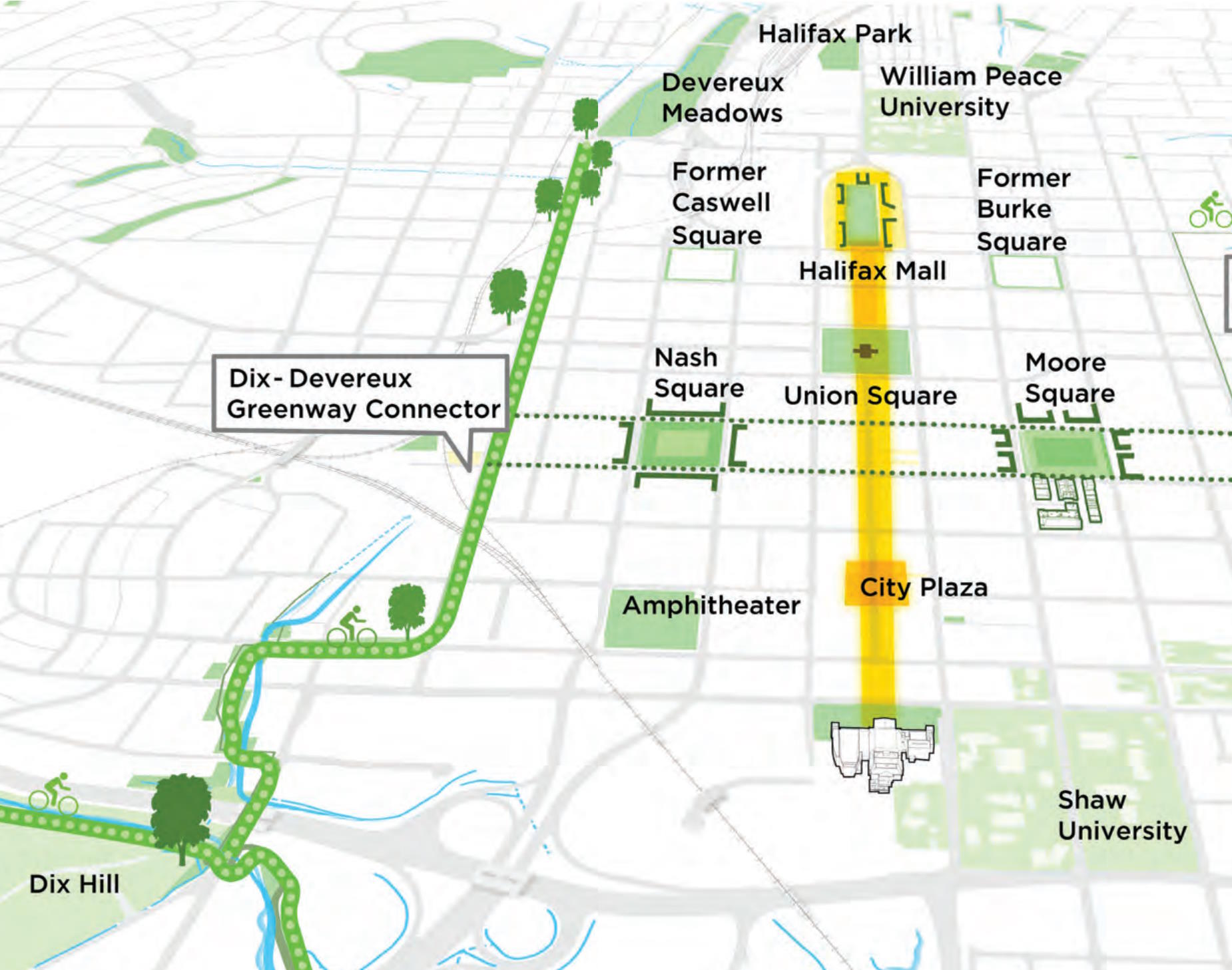
Now in 2023, we call this future connection the Downtown North-South Greenway Connector and you can follow that here on the city’s website. While the Downtown plan suggests a connection to Dix Park, the BikeRaleigh plan extends it further north to Five Points.
As with most infrastructure projects, these things take time and multiple phases. Phase 1 and 2 are already in place and phase 3 is in the planning phase. Phase 3 is the survey I mentioned at the beginning of this post.
I’m going to do more copy and pasting for archival purposes but phases 1 and 2, according to the city’s website, were completed in 2019 and 2021, respectively.
- “Phase 1 of the Downtown North-South Greenway Connector was completed in October 2019. This project included the installation of a south-bound bicycle lane on the west side of Harrington and a north-bound bicycle lane on the east side of West Street. These lanes provide a dedicated bike lane in each direction from Martin Street to Hillsborough Street.”
- “Phase 2 – Complete, October 2021. The bike lanes on West and Harrington Streets were expanded around the Smoky Hollow development near the Publix on Peace Street. Parking and loading zone configurations changed to accommodate the bike lanes.”
The way I describe it, Phase 1 connects Raleigh Union Station to Hillsborough Street. Phase 2 extends the connection north up to Peace. This brings us to today, in the middle of Phase 3 where we want to use West Street to go from Peace up to Wade Avenue.
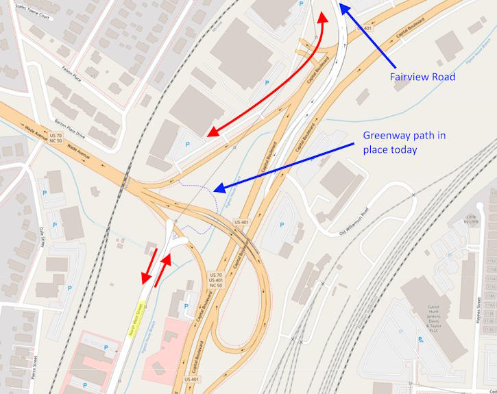
Now you might think that Wade Avenue is not where any cyclist wants to be but in case you weren’t aware, there is an already in-place greenway connection that goes underneath the Wade Avenue flyover (the bridge over Capital Boulevard) putting you on the other side of Wade. After that, it’s a short ride or walk to Fairview Road which is on the edge of the neighborhoods of Five Points.
Phase 3 seems like a critical connection. Sure, it’s very possible to use West Street today to make the connection. No one is stopping you from riding your bike up and down it right now. However, to fulfill the priorities of our bike plan, we need to make this stretch of West Street more accommodating to cyclists and pedestrians.
For me, it’s clear that some help is needed and if you’ve ever cycled north up West Street starting at Peace, you should know what I mean. That hill is brutal. Also, just look at that photo of the current state of West Street at the top of this post. No sidewalks. Just asphalt. No paint even.
For a future post, hopefully not to far in the future, I hope to post an update about how this connector will get riders to Dix Park. Plans have been around for awhile about punching West Street south, under the rail tracks, to connect to itself on the southwest side of downtown. This is the West Street Extension project and there’s a city webpage for that also.
Indeed, in my final act of copying and pasting off the city’s website, we have phase 4:
“Phase 4 of the North-South Downtown Greenway Connector will connect to the Rocky Branch Greenway at Dix Park and use on-street connections most likely on South Saunders, South, and West Streets to reach Cabarrus Street where it will connect to the final phase of the project, the West Street Extension.”
I think this is a pretty exciting cycling path with some notable locations up and down the route. With Dix Park and Five Points bookending the connector, you’ll have the Warehouse District, more specifically Union Station and the now under construction Union Station Bus Facility, Glenwood South, and the future Smoky Hollow Park.
Comments
Comments are disabled here. That's because we're all hanging out on the DTRaleigh Community, an online forum for passionate fans of the Oak City.