Recently, the city has created some online and mobile tracking services for the buses in Capital Area Transit. The best part is that they all have maps associated with them. I love me some maps.
For downtown, this includes the R-Line, which is technically part of CAT and is shown on the CAT tracking page. The Downtown Raleigh Alliance (DRA) tracks the R-Line on their page as well. Below is the link rundown so update your bookmarks.
DRA live map
www.godowntownraleigh.com/get-around/r-line/status
DRA live map mobile version
m.yourhere.com/rline-map.php
CAT Bus tracking
raleighrides.org/
NCSU Wolfline Tracking
ncsu.transloc.com/
I’m mentioning the Wolfline tracking system because it has been around for years and is still the better service of the few, in my opinion. Take a look at it to see what all the services should work towards becoming one day.
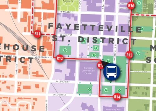
The R-Line mobile site is easy and straight to the point. If you have a smartphone, you can pull up the maps with the location of the buses pinpointed on the route in real time. The bus stops are marked by their appropriate names so finding where you are on the map is easy once you are at an R-Line stop. Streets and their names are also displayed so the map now becomes a personal guide to navigating downtown on your phone. It’s a great start for making the experience of riding a bus slightly easier and puts a system in place that can be easily updated and scaled out as transit in Raleigh grows.
Comments
Comments are disabled here. That's because we're all hanging out on the DTRaleigh Community, an online forum for passionate fans of the Oak City.