Moore Square is a such a vital part of the downtown Raleigh fabric. I love the space here as it truly feels like a space for all and you can see people from all different walks of life. The square organically caters to residents who want some open space, visitors who want to linger around the city, and events, planned or unplanned, in the various sections around this park-like square.
Continue reading →Category / Planning DT Raleigh
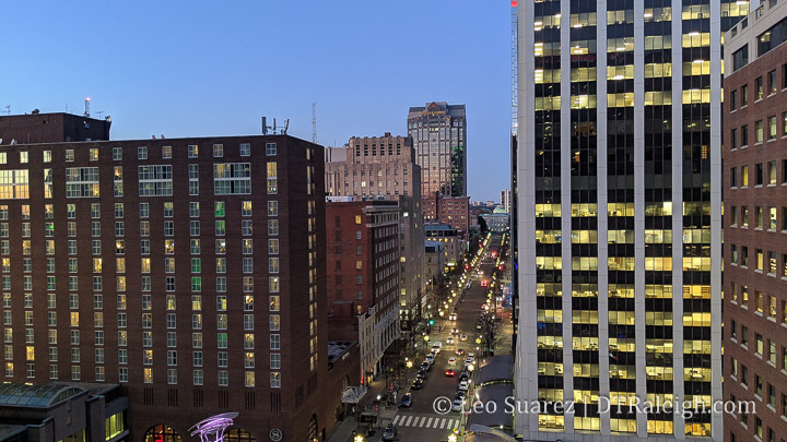
Omni Hotel for Site 2 Announced
It’s all going according to plan.
Straight out of the 2015 Downtown Plan, the southern end of Fayetteville Street, currently being used as surface parking and owned by the city, was to be kept for a major “catalytic” project. In 2015, it was envisioned that a major hotel to serve the convention center and a large corporate relocation would set up on the two sites. Fayetteville Street would then be extended down the middle.
Continue reading →The City’s Latest Plan for Downtown Raleigh Hopes to Invigorate Fayetteville Street and More
[Quick note, most of the photos here were taken on a weekday morning. I was trying to beat the heat plus it’s been a busy summer for me. I mention this because I typically try and get photos with people in it as that is more interesting than the opposite but sometimes you can’t help when inspiration strikes, am I right?]
Announced back in July of this year, the Downtown Raleigh Alliance (DRA) and the city have partnered with a few consultants to create a plan for Downtown as the last few years have seen unanticipated changes. The largest of those being the uptick in remote and hybrid work and how downtown businesses were reliant on a certain number of workers coming to the office and frequenting them for lunch and goods. It is also a great time for a new plan as the previous downtown plan was implemented in 2015 and plenty of policies and recommendations from that one have already been put in place.
Continue reading →Mapping the New Bern TOD, NCODs, and HODs, Oh my!
I’m getting so bad at blog post titles these days. I really do apologize for that one.
What I am getting better at is working with maps and data. It’s still a work in-progress but I wanted to put out this map, shown above, related to the currently proposed New Bern Station Area Plan. You can jump into this topic over at the city’s website as well as this post from Jan 2023.
Continue reading →A Walk Around Shaw University
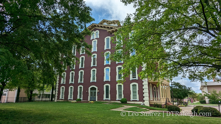
There’s a big rezoning case that’s now being discussed at council. Basically, a majority of Shaw University’s campus is up for an increase in height, if approved. There has been a lot of public comment on this one, from residents and alumni, with concerns. In short, the university is sitting on very valuable land and with the ability to build taller, they can explore options to expand or even partner with developers to lease land for new development.
Continue reading →Gale Street Rezoning For Greater Height, Less Surface Parking
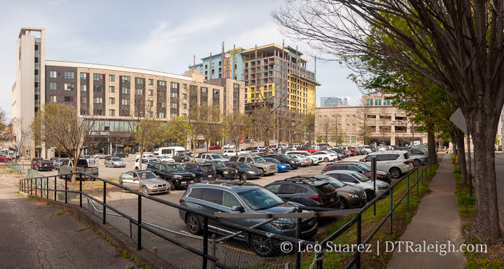
One of the latest rezoning cases for downtown Raleigh, Z-87-22, is up for a public hearing at the city council. This has all the indicators of passing without issue. The planning commission discussion was light, which you can watch here and here. There are very few nearby homeowners. The Raleigh Convention Center is next door. Finally, I’m not sure you can find that many better spots for taller buildings in downtown.
Continue reading →West Johnson Street Rezoning Analyzed
Today, let’s jump over to the corner of West Johnson Street and St. Mary’s. A collection of properties is up for rezoning (Z-55-22) and we’re almost one year into it as the case still has not been denied or approved. Negotiations with residents, mostly from the nearby Forest Park neighborhood, started in May 2022 and the conditions on this rezoning are starting to get a bit much. The latest public hearing, from March 7, 2023, about the case is shown above or you can watch it directly on YouTube here.
Continue reading →New Bern Bus Rapid Transit and Upcoming Land Use Proposals
“With great transit comes great land usability.”
I’m not sure anyone has actually said that quote but maybe someone should. (I’ll take it if it’s up for grabs) The folks I’m really hoping are saying this repeatedly is our own city as they continue to work through the planning efforts of the Bus Rapid Transit (BRT) system.
If you’re coming in fresh to the latest plans on the system then you can jump to the city’s website with an overview of the plans for the four corridors.
Now that it’s 2023, construction should begin on the first corridor of the BRT project. Throughout this year and next, dedicated bus lanes will be added, raised-platform, bus stations will be built, new sidewalks will be added, and traffic signals will be upgraded. We’ll be following along for sure.
What’s even more encouraging about all this are the efforts to slowly shift the dynamic of these BRT corridors by putting in place Transit-Overlay District zoning. It’s great to see the land use compliment the investments in transit.
I see it as a two-sided story. There’s the transit piece, buses, sidewalks, and roads, and then the land use piece requires more urban buildings delivering houses across the income spectrum, spaces for retail that residents can walk to, and office space for businesses. I see it as putting a mix of uses down a single street served by a faster and more reliable form of transportation.
The two stories for New Bern are summed up on these links and I encourage anyone reading to take a look:
- Wake BRT: New Bern Avenue (for more on the bus itself)
- Station Area Planning: New Bern (for more on the land use proposals)
I also can’t help but highlight a great map. This one shows the proposed rezoning changes for the New Bern corridor so if you drive down that street or live near it, take a look.
The new BRT changes are coming and as mentioned earlier, construction will kick off this year. The rezoning application is in the final stages and when submitted will hit the Raleigh Planning Commission. I imagine it’ll be a much discussed topic throughout 2023.
For me, you can’t have the BRT running effectively without the right land use so I’m in full support of this rezoning plan. I’m sure there are edge cases that can be tweaked, and that’s fine as it’s a rezoning request across numerous properties, but without the planning piece put in place, I would be nervous about the BRT’s effectiveness for current and future residents in Raleigh.
We also can expect similar rezoning cases come out as the other three corridors mature and come close to their construction dates. BRT will be one of my “most watched” projects this year so I’ll leave this post right here with more thoughts and updates to come in the future.