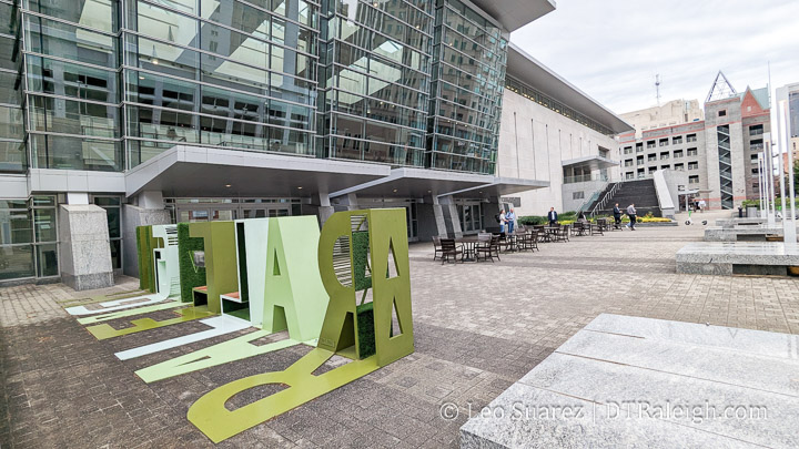
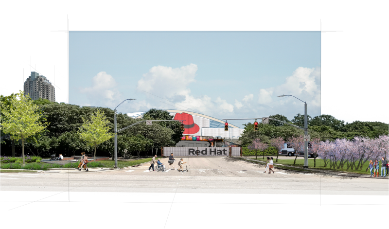
Mapping the New Bern TOD, NCODs, and HODs, Oh my!

I’m getting so bad at blog post titles these days. I really do apologize for that one.

What I am getting better at is working with maps and data. It’s still a work in-progress but I wanted to put out this map, shown above, related to the currently proposed New Bern Station Area Plan. You can jump into this topic over at the city’s website as well as this post from Jan 2023.

Continue reading →

A Walk Around Shaw University

There’s a big rezoning case that’s now being discussed at council. Basically, a majority of Shaw University’s campus is up for an increase in height, if approved. There has been a lot of public comment on this one, from residents and alumni, with concerns. In short, the university is sitting on very valuable land and with the ability to build taller, they can explore options to expand or even partner with developers to lease land for new development.

Continue reading →

Gale Street Rezoning For Greater Height, Less Surface Parking

One of the latest rezoning cases for downtown Raleigh, Z-87-22, is up for a public hearing at the city council. This has all the indicators of passing without issue. The planning commission discussion was light, which you can watch here and here. There are very few nearby homeowners. The Raleigh Convention Center is next door. Finally, I’m not sure you can find that many better spots for taller buildings in downtown.

Continue reading →

West Johnson Street Rezoning Analyzed

Today, let’s jump over to the corner of West Johnson Street and St. Mary’s. A collection of properties is up for rezoning (Z-55-22) and we’re almost one year into it as the case still has not been denied or approved. Negotiations with residents, mostly from the nearby Forest Park neighborhood, started in May 2022 and the conditions on this rezoning are starting to get a bit much. The latest public hearing, from March 7, 2023, about the case is shown above or you can watch it directly on YouTube here.

Continue reading →

New Bern Bus Rapid Transit and Upcoming Land Use Proposals

“With great transit comes great land usability.”

I’m not sure anyone has actually said that quote but maybe someone should. (I’ll take it if it’s up for grabs) The folks I’m really hoping are saying this repeatedly is our own city as they continue to work through the planning efforts of the Bus Rapid Transit (BRT) system.

If you’re coming in fresh to the latest plans on the system then you can jump to the city’s website with an overview of the plans for the four corridors.

Now that it’s 2023, construction should begin on the first corridor of the BRT project. Throughout this year and next, dedicated bus lanes will be added, raised-platform, bus stations will be built, new sidewalks will be added, and traffic signals will be upgraded. We’ll be following along for sure.

What’s even more encouraging about all this are the efforts to slowly shift the dynamic of these BRT corridors by putting in place Transit-Overlay District zoning. It’s great to see the land use compliment the investments in transit.

I see it as a two-sided story. There’s the transit piece, buses, sidewalks, and roads, and then the land use piece requires more urban buildings delivering houses across the income spectrum, spaces for retail that residents can walk to, and office space for businesses. I see it as putting a mix of uses down a single street served by a faster and more reliable form of transportation.

The two stories for New Bern are summed up on these links and I encourage anyone reading to take a look:

I also can’t help but highlight a great map. This one shows the proposed rezoning changes for the New Bern corridor so if you drive down that street or live near it, take a look.

The new BRT changes are coming and as mentioned earlier, construction will kick off this year. The rezoning application is in the final stages and when submitted will hit the Raleigh Planning Commission. I imagine it’ll be a much discussed topic throughout 2023.

For me, you can’t have the BRT running effectively without the right land use so I’m in full support of this rezoning plan. I’m sure there are edge cases that can be tweaked, and that’s fine as it’s a rezoning request across numerous properties, but without the planning piece put in place, I would be nervous about the BRT’s effectiveness for current and future residents in Raleigh.

We also can expect similar rezoning cases come out as the other three corridors mature and come close to their construction dates. BRT will be one of my “most watched” projects this year so I’ll leave this post right here with more thoughts and updates to come in the future.

Parking Minimums Removed Across the City

This week, the Raleigh City Council voted to remove all parking minimums for new developments across the entire city. This extends a previous parking reduction that was done in 2020 that mainly affected the downtown area. You can watch the discussion and vote in the embedded video above or directly on YouTube here.

It is worth reiterating that parking is not banned city-wide. It only removes the minimums required and, generally speaking, allows new projects to choose the amount of parking to be built. In some cases, there are maximums in place.

From what I’m seeing, right now new buildings in downtown are building above the minimums anyway. In the future, as transit options come online and our city adds more people, those who prefer to travel car-light or even car-less will benefit from a city that doesn’t dedicate so much space to parking vehicles.

Indeed, climate impacts and sustainability is a big driver of this change, as written out in the text change itself.

SUMMARY OF IMPACTS

Adoption of TC-11-21 would:

1. Because it removes subsidies and incentives for car ownership (because rent typically does not vary depending on whether a car is stored on a property or not, so there is no extra cost for car ownership) it would tend to reduce vehicle miles traveled and associated air pollution and carbon
emissions.

2. Mitigate the climate change, stormwater, and other impacts created by large areas of paved parking.

3. Tend to reduce the cost of housing and goods and services by requiring less land to be used for vehicle storage. It would prevent households without cars from paying for parking they do not use.

4. Potentially lead to increased demand for on-street parking in some locations. If issues arise, excessive demand can be addressed through the creation of new residential parking permit areas, adjusting on-street parking pricing, and providing additional public parking.

https://go.boarddocs.com/nc/raleigh/Board.nsf/files/CC5L9Q54981F/$file/20220315PLANDEVTC-11-21StaffReportandDraftOrdinance.pdf

From a sustainability and land-use point-of-view, I think it’s great to address problems of having too little parking on a case-by-case basis (point #4) rather than the problems of having to much. Well managed on-street parking programs are common in larger cities and it’s probably time Raleigh get into that game.

The change is a great, incremental step in the right direction and it’ll take time for the city to adjust. The next step will be to give Raleighites a transit system that allows for all of us to get around while putting less miles on our cars. That kind of Raleigh may lead to shorter buildings (less floors for parking), more destinations closer together, and more vitality to neighborhoods.

Would you pay for parking if it meant you were always on time for lunch at The Village District?

Today, I have a guest post by a fellow Raleigh content creator. Jed Byrne loves Raleigh, especially its people and places. He tries to engage with both on a daily basis. Jed tweets about spaces and places at @Oakcitycre, hosts the Dirt NC podcast, and sends a weekly development newsletter through www.OakCityCRE.com. He always enjoys connecting with new people, so reach out on social or via email at oakcitycre@gmail.com.

For Raleigh to maintain and grow its reputation as a city of innovation, it’s important for us to experiment with dynamic parking pricing. I can think of no better place to pilot experimental parking than The Village District! But first, I think it’s important to share a bit of history.

If you have any questions about this post or have any Village District parking stories to share, hit me up on twitter at @OakCityCRE!

History of Innovation

The Village District has been an innovator since the beginning. Built in 1949, it was one of the first shopping centers in the country designed for the automobile age. In fact, the Village District was inspired by Country Club Plaza in Kansas City, the first center of its kind in the country!

Parking at The Village District

In all of my time here in Raleigh the congested parking situation at The Village District hasn’t kept people away. As Yogi Berra said “Nobody goes there anymore. It’s too crowded.”

In order to improve the shopping experience at the Village District and increase sales, there are really only two options that the landlord can control when it comes to parking. They can increase the number of parking spaces, or increase the number of people who use the existing spaces per hour.
It turns out that expanding the number of parking spaces at The Village District has already been tried. According to WRAL a parking deck lived at The Village District for 40 years!

The Original Parking Innovation

Originally built in the 1960s, the deck was demolished in 2005. You can see the original structure below in this satellite images from March 2002.

This image has an empty alt attribute; its file name is R21yYdP1d-wOhyUlZ_JmAHJLlMyakxUVll7Er7OpxxkQht7L6UCQCgBcz3x5yRi9S1U-G7a5WZEGz7JXdYr62N6kBy-XGufcy34IAaebookJ2TMsUwM6hlm-3bF_6Jr02_7dozJ7
Source: Google Earth

There was also a parking structure where the Berkshire Village District Apartments now stand at the corner of Oberlin Road and Clark Avenue. 

I couldn’t find many historical images of the parking deck, but my friend Ian Dunn shared the following photo from 1992 of the parking structure undergoing some demolition work.

NO_94411_Fr15 Cameron Village - From the N&O Negative Collection, State Archives of North Carolina. Photo copyrighted by the News and Observer. Illegal to use without express permission from the N&O.
Source:  NO_94411_Fr15 Cameron Village – From the N&O Negative Collection, State Archives of North Carolina. Photo copyrighted by the News and Observer. Illegal to use without express permission from the N&O.
NO_94411_Fr18 Cameron Village - From the N&O Negative Collection, State Archives of North Carolina. Photo copyrighted by the News and Observer. Illegal to use without express permission from the N&O.
Source: NO_94411_Fr18 Cameron Village – From the N&O Negative Collection, State Archives of North Carolina. Photo copyrighted by the News and Observer. Illegal to use without express permission from the N&O.

The demolition work above must have been for a modification because the second layer of parking stood for another 13 years.

In all my years of studying the built environment, this is the only case where I have heard of structured parking being removed from a project. From a practical standpoint, I am glad they removed the parking deck, though I never got to experience the deck first-hand. I think one of the main attractions to the Village District is the open air feel, which would have been hampered by structured parking. I am sure that the decision to remove parking wasn’t easy. Today a structured parking space costs $25,000-$35,000, roughly 5x the cost of a surface parking space.

Free Parking

Since adding supply didn’t make things better at The Village District, I think the time has finally come to address the congestion caused by “free” parking, once and for all. 

In the book The High Cost of Free Parking by Donald Shoup, you can learn all about how “free to you” parking spaces actually have a lot of costs. For starters, there are the indirect costs of construction and maintenance that are paid by the tenants. Those costs are ultimately passed through to the customers who must cover the cost of the tenants rent. 

There are also non-financial costs: the stress of congestion, the time and the environmental impacts of circling the lot looking for parking, and the induced demand for driving to shop in the first place.  

The costs of “free parking” are ultimately paid by all shoppers, whether they drive or not, and even whether they spend money at the shopping center or not.

Future Innovation

The Village District has been a place of innovation from the start. Its designers innovated what the shopping center looked like when they designed one of the first automobile-centric centers. Its owners innovated both by installing and ultimately demolishing the structured parking. I think it’s now time to innovate again. 

Using a platform like Passport, which is already used by the City of Raleigh, The Village District could start charging for parking in a way that ensured there would almost always be available spaces in the parking lot. Because parking demand changes over time, the Passport pricing structure could increase and decrease as well. At lunch, nights, weekends, and holidays, pricing would increase. 

These higher prices would encourage shoppers to only stay for the time they need to, and would also ensure that parking was always available. With more efficient use of parking and higher customer turnover the overall sales revenue would increase. Plus, if people knew they always had a place to park at The Village District, more people would come and shop!

So, what do you think? Would you pay – directly – to park at The Village District if it guaranteed you’d be able to find a spot quickly? I would!

Let me know what you think or share any Village District Parking stories by tweeting me at @OakCityCRE

Sources:

WRAL article  https://www.wral.com/news/local/story/114956/

Village District age: https://shopvillagedistrict.com/about/

Yogi Berra quote: https://www.brainyquote.com/quotes/yogi_berra_100418

It’s All About That Height in Downtown Raleigh

Things have been slow at DTRaleigh HQ with some recent holiday downtime. (I hope the same for you as well) Also in the background, I’ve been flexing my tech skills a bit and working with maps lately. I went down a rabbit hole with the zoning information on the city’s open data website and started thinking about building heights.

But first, a refresher.

For the longest time, Raleigh’s zoning code had two limits with regards to building height; number of floors and the measured height in feet. To a certain degree, the “height in feet” limit has been removed and today, only the number of floors is the limit we care about. That may not be true city-wide but seems to be for downtown Raleigh, where we see a concentration of floor limits as high as 40.

Since this is a downtown Raleigh blog, let’s look at just that. Downtown is, generally, given the DX zoning type. You can see a map of all zoning in Raleigh here but if I filter on just downtown, it looks something like this.

See the map in arcgis

After filtering the dataset and looking only at the ‘DX’ zoning type (DX = Downtown Mixed-use) we can see areas that we generally refer to as Downtown Raleigh and shapes on a map with different zoning. To quickly read zoning labels in Raleigh, the formatting typically goes in this order:

  • Zoning Type
  • Maximum height allowed
  • Frontage type

So for example, when I see ‘DX-5-UG’, that stands for ‘Downtown Mixed-Use with a 5-story height limit, Urban General frontage’ There are a bunch of frontages that are worth going over but that’s for another day. Today, I’m looking at that middle number only.

I wanted to get a sense of what the maximum heights allowed are but the map above doesn’t show it to me easily without clicking every shape and noting the zoning. I went ahead and created this map below which shows darker shading on areas that allow higher heights, such as 12, 20, and 40 story maximums. Conversely, the lighter shading indicates lower heights including 3, 4, 5, and 7 story maximums.

Source: Open Data Raleigh – link. See larger map here.

The map is using the same dataset from the city so it should be up-to-date whenever you look at it.

It’s probably obvious to guess that the tallest height allowances are around Fayetteville Street. Two Hannover, with the newly renamed Truist Bank on its crown, and the Wells Fargo Capitol Center have been around since the early 1990s. When you add in PNC Plaza, opened around 2008, the thought of our city’s tallest towers and where they are doesn’t surprise anyone. Taller towers nearby are allowed and could come to this area in the future.

The map does show some easily explained anomalies such as the five-story maximum at Martin and Fayetteville. This is where the historic post office sits and since that’s not going anywhere any time soon, a rezoning just seems silly. Open space on Moore, Nash, and Union Square follows the same principle with their 3-story maximums.

If you are following me so far, you may think that the tallest towers in downtown have always been, and may always be, situated around the core business district around Fayetteville Street. That seems like a trajectory that downtown has been on since we started calling it downtown Raleigh.

However, there are other districts that now have 40-story maximum zoning. I say ‘now’ as these have been approved within the last few years. If I take my map and filter on only the DX zoning type with max heights at 40, we would get a visual that looks like this.

Source: Open Data Raleigh – link. See larger map here.

In this map, we can see two clusters of 40-story max zoning outside of the traditional downtown core of Fayetteville Street, those being the warehouse district and the northern end of Glenwood South. If we look at the effective dates of the zoning in these two areas, they are all in 2019 or later.

Just a side note, from the data for the whole city, it looks like the rollout of the newest zoning per our development ordinance was throughout 2016 so while we see some zoning in downtown effective as of 2016, there’s a lot of it across the city. I want to say this was the transition from the old zoning codes to the new ones so anything with a 2016 effective date was not a market-driven zoning change more or less.

The maps above show current zoning and doesn’t consider active cases under review. As of this writing in December 2021, we can further show this clustering activity if we consider the in progress rezoning cases in downtown shown in this table.

Zoning CaseLocationCurrentProposed
Z-61-21Glenwood SouthDX-20-UGDX-40-UG-CU
Z-52-21Warehouse DistrictDX-12-SHDX-40-SH-CU
Z-78-21Warehouse DistrictDX-5-SH; DX-12-SH-CUDX-20-CU
Z-43-21Fayetteville StreetDX-20-SHDX-40-SH
Z-69-21Moore SquareDX-3-SH; DX-12-UG-CUDX-12-SH; DX-12-UG
Z-41-21Southeast DowntownDX-3-DE w/HOD-GDX-3-UG-CU

You can see that the first four cases listed above show more height in the same districts with three of them within these new clusters at the 40-story max height. Glenwood South and the Warehouse District are poised to really add much more space.

Why might this be happening? Is this an accident? Actually, it’s all according to plan.

Adopted in 2015, the Downtown Experience Plan has many recommendations in it and a subset of redevelopment recommendations suggest we are right on track. You can dive into the plan here. (pdf link) I mean, this image alone from the plan is spot on.

We have talked plenty about the downtown plan over the years, which you can revisit here, and it’s recommendations say they are for 10 years. Perhaps later this decade it’ll be time for a new one?

I could keep going with thoughts about all this rezoning. Remember that maximum height doesn’t mean the buildings are built that high. Also a 20-story residential tower is shorter than a 20-story office tower. Zoning seems to be enjoyable to the civic geeks out there because of all these nuances, am I right you all?

There’s also a pretty wide gap between the 20-story max zoning and 40-story max. If a developer only wants to build a 23-story tower, they must apply for that 40-story max. Height conditions may be a thing of the future as the eastern most shape on that map above, the one by Marbles, has a condition limiting it to 30 floors. (Nuance!)

The main takeaway that I think I’ve gotten at is that we all need to be watching the Warehouse District and Glenwood South as they may really see a jump in development this decade. If these rezoning cases to new heights seem like a drastic change, just look back and see that it’s all part of Raleigh’s plan.