Embedded above (direct link here) is the video from the June 4, 2024 Raleigh City Council meeting where the latest updates and discussion took place related to the Transit-Oriented Development (TOD) rezoning case for the New Bern Avenue corridor. We’ve been following this for awhile now and the rezoning case here, which sets to change the zoning for over 700 properties on or near the upcoming Bus Rapid Transit line for New Bern Avenue, is being worked on in phases. I wanted to share my notes and provide a summary of the latest.
Feel free to dive right into the video above, as it opens with a nice summary, and check out these resources on the city’s website:
Remember the R-Line? If not, you can refresh your memory now as we have the fare-free circulator service back up and running. The service was put on hold when the COVID pandemic began in early 2020. Long time residents may remember the old route as being a loop around downtown but it’s worth mentioning that it’s actually a bit different now.
Above is the video for the March 5, 2024 City Council evening session where council revisits the topic of rezoning properties along New Bern Avenue in an attempt to support the now under construction Bus Rapid Transit route. It’s actually a more manageable 40 or so minutes to watch so I encourage anyone to check it out or watch it directly on YouTube here.
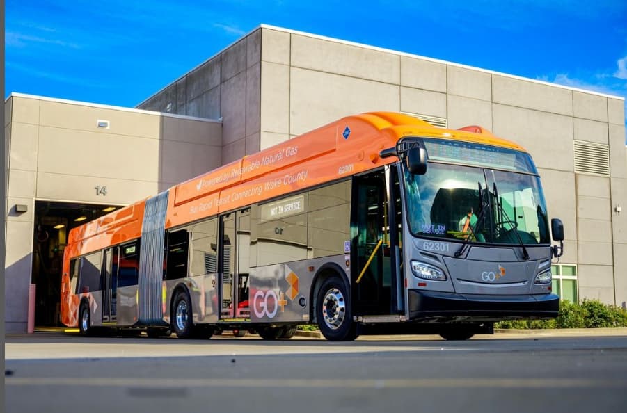
In November 2023, the first of four bus-rapid transit (BRT) routes, years in the making, broke ground. The first route out the gate will be the eastern route. This one services the New Bern Avenue corridor between downtown, WakeMed, and parts around New Hope Road. We just might be riding around in articulated buses some time in 2025.
The increase in bus service is finally happening, kickstarted back in 2016, after Wake County voters decided to increase the sales tax in order to fund expanded transit. The second half of the transit journey comes with the accompanying land use and I think 2024 will be the year Transit-Oriented Development (TOD) becomes a household phrase. (or at least to all you readers out there)
I spent some time this week with a survey from the city about possible plans to reconfigure North West Street between Peace Street and Wade Avenue that could accommodate bike lanes, walking paths, and a different parking layout. If that excites you, jump right on over to that survey here to let them know what you think. If I still got you, I wanted to revisit the plans for more bicycle infrastructure along West Street, how it’s going, and what we might expect in the future.
All throughout the cities of North Carolina and South Carolina, the development boom times have really kicked in within the last few decades. In most cases, this new growth in the South has led to car-centric development where driving a vehicle is almost required to navigate your city. For those able to drive safely, this has become part of Southern culture. However, not everyone can or wants to drive for their daily tasks. Our sidewalk networks, when present, pick up the slack here. For pedestrians with mobility challenges, high-quality sidewalks are a necessity.
I’m getting so bad at blog post titles these days. I really do apologize for that one.
What I am getting better at is working with maps and data. It’s still a work in-progress but I wanted to put out this map, shown above, related to the currently proposed New Bern Station Area Plan. You can jump into this topic over at the city’s website as well as this post from Jan 2023.
I’m not sure anyone has actually said that quote but maybe someone should. (I’ll take it if it’s up for grabs) The folks I’m really hoping are saying this repeatedly is our own city as they continue to work through the planning efforts of the Bus Rapid Transit (BRT) system.
If you’re coming in fresh to the latest plans on the system then you can jump to the city’s website with an overview of the plans for the four corridors.
Now that it’s 2023, construction should begin on the first corridor of the BRT project. Throughout this year and next, dedicated bus lanes will be added, raised-platform, bus stations will be built, new sidewalks will be added, and traffic signals will be upgraded. We’ll be following along for sure.
What’s even more encouraging about all this are the efforts to slowly shift the dynamic of these BRT corridors by putting in place Transit-Overlay District zoning. It’s great to see the land use compliment the investments in transit.
I see it as a two-sided story. There’s the transit piece, buses, sidewalks, and roads, and then the land use piece requires more urban buildings delivering houses across the income spectrum, spaces for retail that residents can walk to, and office space for businesses. I see it as putting a mix of uses down a single street served by a faster and more reliable form of transportation.
The two stories for New Bern are summed up on these links and I encourage anyone reading to take a look:
I also can’t help but highlight a great map. This one shows the proposed rezoning changes for the New Bern corridor so if you drive down that street or live near it, take a look.
The new BRT changes are coming and as mentioned earlier, construction will kick off this year. The rezoning application is in the final stages and when submitted will hit the Raleigh Planning Commission. I imagine it’ll be a much discussed topic throughout 2023.
For me, you can’t have the BRT running effectively without the right land use so I’m in full support of this rezoning plan. I’m sure there are edge cases that can be tweaked, and that’s fine as it’s a rezoning request across numerous properties, but without the planning piece put in place, I would be nervous about the BRT’s effectiveness for current and future residents in Raleigh.
We also can expect similar rezoning cases come out as the other three corridors mature and come close to their construction dates. BRT will be one of my “most watched” projects this year so I’ll leave this post right here with more thoughts and updates to come in the future.