The city’s newest plan for improving the pedestrian experience in Raleigh was posted on the city’s website a few weeks ago and public comments are being taken on it until this Friday. Whether you realize it or not, the sidewalks are a significant transportation system and are important for multi-modal trips around Raleigh.
Last year, voters approved a $40 million transportation bond with $4.75 million going towards sidewalk related improvements. The comprehensive plan lists out some of those projects as well as moving Raleigh to a new system of prioritization for future projects.
I found the plan thorough and easy to read. It goes into the design of new sidewalks and intersections, best practices, and uses technical language to explain things but not to a point that confuses a reader. This plan can really empower a neighborhood that’s looking to make changes and allow them to “speak the language” when researching the option to petition for improvements.
Here is my chapter to chapter summary for those preferring an even lighter read.
Executive Summary
Brief and to the point. The executive summary introduces the plan and summarizes the plan’s goals and offers a taste of some of the projects coming in the next few years. I’ll leave this for you to enjoy yourself.
Chapter 1: Introduction and Plan Goals
The City has 1,761 miles of roadways, 1,190 miles of sidewalk, 12 miles of bike lanes and over 60 miles of bikeable greenway trails. Forty-two bus routes on the Capital Area Transit system carry riders to and from their destinations, boarding and alighting at over 1000 bus stops.”
Chapter one introduces the fact that Raleigh has an extensive transportation network of sidewalks, roads, and the growing greenway network. At the same time, the plan recognizes that there is still work to be done. There are holes in the sidewalk network that exist as well as inadequate pedestrian facilities at bus stops and intersections. With that, this chapter expands on the purpose of this document, to guide the city in sidewalk investments, raise awareness for the benefits of walking, and improve the quality of the pedestrian network.
Chapter one states that two goals the plan will help Raleigh achieve are to:
- Quadruple pedestrian “journey to work” mode share by 2020
- Receive “Walk-Friendly Community” designation by the Pedestrian and Bicycle Information Center (PBIC)
Complete Streets is a concept mentioned in this chapter and the plan really pushes for those concepts in future projects. At the same time, new development should be guided to be “pedestrian-oriented development rather than pedestrian-accessible development.”
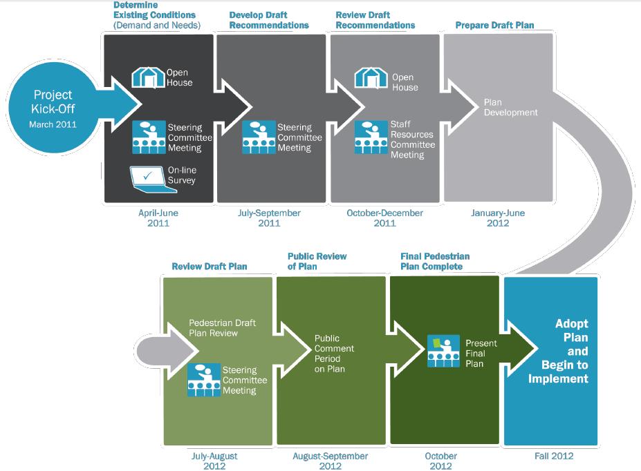
The chapter wraps up with a summary of past public open houses attended by citizens, the surveys and information gathered that went into the plan, and a summary of the upcoming chapters.
Chapter 2: Existing Conditions
Many Raleigh streets include a sidewalk on at least one side; however, sidewalks are missing on some streets and in many cases gaps limit the connectivity of the sidewalk network.
Chapter 2 attempts to paint a picture of our existing network, the good and the bad. The city maintains all of the sidewalks, trails, and bikeways in Raleigh. With over 1,000 miles of city-maintained roads, the plan lays out some terminology of different types of roads, from principal arterials to collector streets, with each list containing examples around the city. The chapter then goes on to show where pedestrian amenities are inadequate or missing entirely.
Chapter two also contains the answers from a survey that went out about walking in Raleigh. 872 citizens responded to questions like, “What do you like best about walking in Raleigh?” and “What would improve walking in Raleigh?” Some stand out responses were:
- “What makes walking difficult in Raleigh?” 78.9% responded “sidewalk gaps”
- “What would improve walking in Raleigh?” 80.6% responded “sidewalks on at least one side of most streets”
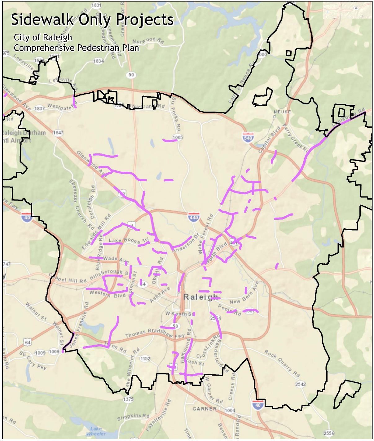
The chapter then goes into explain the measured sidewalk demand and needs around the city which is nicely shown in this map.

Click for larger, full view in another window.
Anticipated demand for walking was calculated by the presence of certain things around the city. Things like higher population density and pedestrian generators (colleges and universities, tourist attractions, schools, transit facilities, etc.) are factors for measuring the demand for sidewalks and other pedestrian related facilities.
To sum up, the chapter states four main themes from the citizen surveys, public input, and data gathered:
- Install sidewalks where missing.
- Maintain sidewalks where they exist.
- Make it easier for pedestrians to cross the street.
- Change motorists’ behavior with respect to pedestrians.
Chapter 3: Best Practices, Design Standards and Raleigh’s Sidewalk Program
Chapter three starts to get into the “OK, so now what?” part of the conversation. Design, Complete Streets, pedestrian-friendly roadway design, and improving safety for all users are high-level goals that need to be accomplished in order to fix the issues stated in chapter two.
First, the plan recommends to use proven sidewalk and road intersection treatments that will improve safety and travel for pedestrians. The list of treatments, including pedestrian countdown signals, advanced yield markings, and high visibility crosswalks just to name a few, are rated based on Measures of Effectiveness (MOE) and Crash Reduction Factors. (CRF) This is proven data from places that have already implemented them and the plan lists out each one’s rating against the other.
A number of examples are listed with an overview and examples of each type. Rectangular Rapid Flash Beacons, (RRFB) Leading Pedestrian Interval (LPI), crossing islands, the list goes on. Reading through these examples, the comprehensive plan is now a toolbox the city can use to improve problematic streets or intersections.
All public transit bus stop locations should be safe, convenient, well-lit, clearly visible, and accessible.
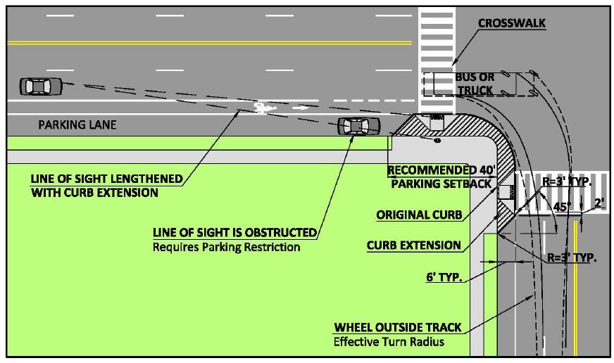
Chapter three then continues with 12 intersection templates that adopt some of these best practices. An example of one is below.
So how should the city choose which sidewalks to work on over others? The plan suggests changing the way that sidewalk projects are prioritized. The existing method ranks projects from 0-10 based on evidence of need, cost, feasibility, and a few other factors. The problem with the current system is that it takes too long, penalizes a greatly needed project for being expensive or very difficult to implement, and there is inconsistency between scoring different projects.
The new prioritization plan takes a more objective approach. This plan will not use feasibility or cost as a factor but rather Geographic information system (GIS) data to gather demand and need. Projects can then be ranked by data and not humans which will eliminate any bias or inconsistency between reviewers.
Chapter 4: Pedestrian Facility Recommendations
Chapter 4 is the “examples” chapter. Six locations in Raleigh were selected and the design concepts that we’ve read about earlier are now applied to something real. The six locations are:
- Avent Ferry Road between Varsity Drive and Centennial Parkway
- Glenwood Avenue (US 70) between Pleasant Valley Road and commercial driveway at Pleasant Valley Promenade
- Brier Creek Parkway between Little Briar Creek Lane and Skyland Ridge Parkway
- Martin Luther King Boulevard between Blount Street and Garner Road
- New Bern Avenue between 3600 and 3800 New Bern Avenue
- Wake Forest Road between the Beltline off-ramp and St. Albans Drive
Each location has a summary of issues and suggested improvements that can be implemented here. The chapter also includes maps of the streets and intersections with the pedestrian improvements laid on top.
Chapter 5: Programs and Initiatives For Walkable Raleigh
Up to this point, the plan has talked about design and how to make the sidewalk safer and an overall improved experience. Education and awareness is still an important piece of the puzzle after the concrete has dried. Chapter five goes over programs that currently exist and ones that could exist to promote walking in Raleigh.
The plan recognizes some of the current walking related programs that take place in Raleigh. “Watch for Me, NC”, WalkRaleigh, and See Click Fix are all implemented programs that anyone can use today while walking. There is even a program set up where citizens can petition to have a sidewalk installed by the city.
For the future, the plan recommends almost 20 different programs. Some include Safe Routes to School, regular pedestrian counts at different locations in the city, and hosting driver education/awareness campaigns.
Chapter 6: Summary of Recommendations
Chapter six is short summary chapter but keeps the themes of this entire plan in perspective with its recommendations. Some suggestions listed in this chapter include:
- Collaboration between Capital Area Transit (CAT) and Triangle Transit (TT)
- Expand online resources
- Develop a sidewalk asset management system
This chapter is a good one to read if you happen to skip over some of the previous ones.
Chapter 7: Implementing The Plan
“Easier planned than done” right? Anyway, chapter seven lays out a timeframe of when to actually do some of this stuff. The plan does mention some funded sidewalk projects and this chapter has maps showing which projects should be implemented each year for the next four years.
Click for larger, full view in a new window.
There are also recommendations on what the city should do in the immediate future, short term, and longer term, more specifically to name a few:
- Within three years, install missing sidewalks, update city codes and engineering standards, and implement programs to improve pedestrian orientation/accessibility in new developments.
- Within five years, install sidewalks as part of all Capital Improvement Plans, (CIP) continue to install missing sidewalks, and continue converting the available information about sidewalks into GIS layers.
- Within ten years, identify funding for previously unfunded projects.
More detail with specific action items are listed in the chapter, each grouped by these yearly timeframes.
Chapter 8: Longer Term Vision
Consistent with the vision set out in the City’s 2030 Comprehensive Plan to make Raleigh “…workable, livable, and prosperous. . ,” the City can adopt a longer term transportation strategy focus on the broader pedestrian experience by creating attractive, high quality pedestrian places.
Chapter eight wraps the plan up with ideas and examples of how all road users are affected by changes to its makeup. Balance seems to be the major theme here and the plan is trying to show how changes to the road can be combined so that all users, from pedestrians to vehicle drivers, experience the same level of service on each road. This is the ultimate goal for the city.
Comments
Comments are disabled here. That's because we're all hanging out on the DTRaleigh Community, an online forum for passionate fans of the Oak City.
Here’s an interesting article about why “WalkScore” and the distance from one place to a destination is not always the best measure of walkability. http://www.theatlanticcities.com/commute/2012/08/walk-score-great-it-still-doesnt-capture-walk-appeal/2858/
In addition to sidewalk improvements, a priority should be to create ‘walkable corridors’ that have buildings with active uses at the sidewalk level. For example, Hillsborough and West Morgan Streets between NCSU and downtown, with smarter urban architecture this corridor could easily stimulate more pedestrian trips between the two destinations.