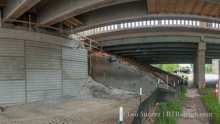
Here are some observations from a walk along Peace Street, specifically underneath the new Capital Boulevard bridge. The photo above shows the old bridge, on the right, and the new bridge, on the left. You can see with the upgraded design that a lot of space is reclaimed when you compare the old “rock mound foundation” versus the “concrete wall foundation” of the new. (like my technical terms?)
It’s almost a vehicle lane, about 12-14 feet, on each side!
This made me pull out the map and below is the one shared from the NCDOT project page. When looking at it, up is West (peace going up/down) with Capital going left-to-right and the dark red being the new bridge.
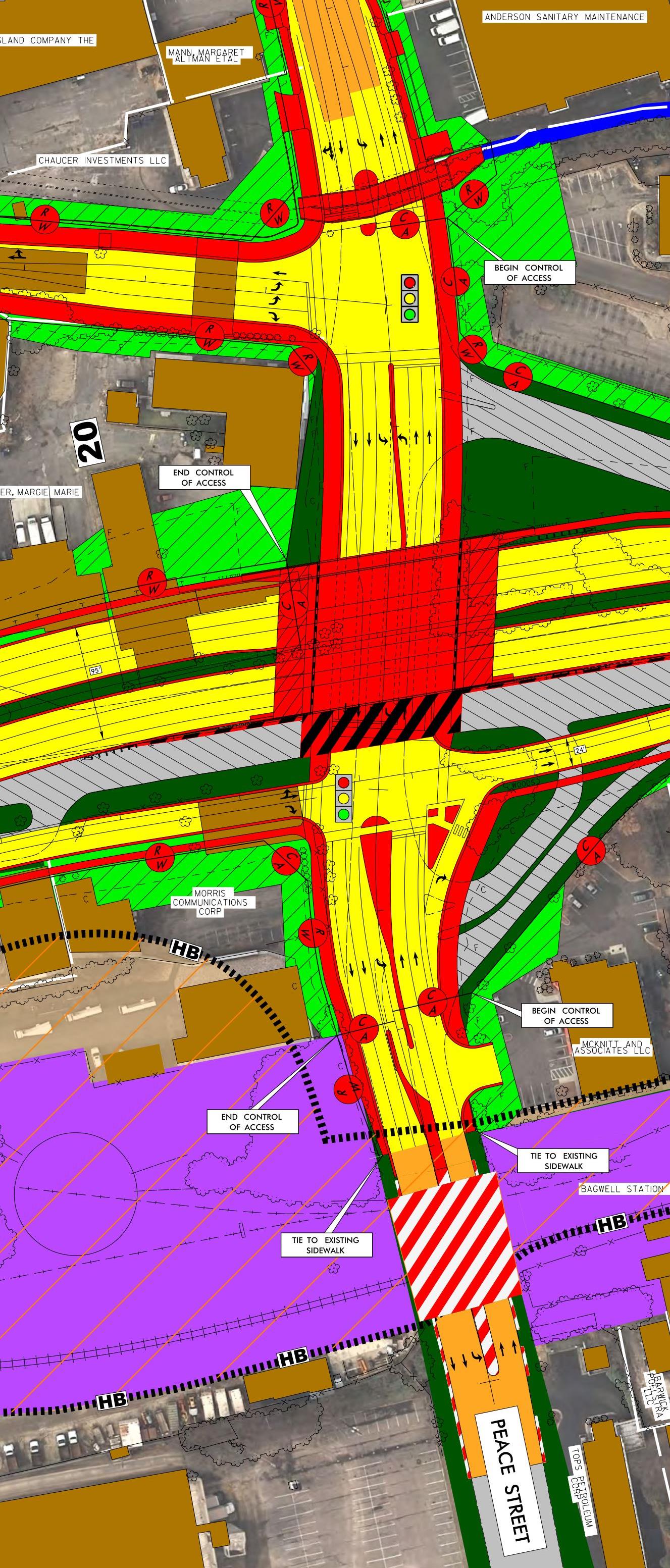
What is great to see is that while Peace is wider, it will still be a two-lane road just like today. The additional space is being given to turns lanes but also wider sidewalks and bike lanes. The bike lanes aren’t very clear on this map but if you look hard, they are there.
I will say that some of the added road space is going toward center turn lanes also. Either way, the road has to slim down because the CSX bridge to the east isn’t getting any wider.
Anyway, it’s cool to see this come together one small piece at a time.
Comments
Comments are disabled here. That's because we're all hanging out on the DTRaleigh Community, an online forum for passionate fans of the Oak City.
I know it was joke, but in case you were curious or semi-serious, the “Rock Mound Foundation” is not the foundation. The rock is just protecting the ground slope from the actual concrete foundation on steel h-piles to the roadway. The “concrete wall foundation” is similar, as it’s not technically part of the foundation of the bridge structure. The real foundation of a concrete cap and steel h-piles are behind the wall. The MSE wall just holds back the earth.
Jeff, thanks for that. I don’t know the technical terms so just using the lay-person speak. :)
Thank you Leo,
I am very glad to see the update/picture. I appreciate you always venturing out and about with your camera in hand. I truly look to you for all things updated downtown. You’re the best!
I mentioned this a few years back in some conversations, but I’ll say it again. I’d love to see some narrow sundries shops/stands under that bridge to activate that space with foot traffic. I know it’s a pipe dream, but a boy can dream, can’t he?
If we can’t get shops, I certainly hope that it’s well it and has some sort of public art to make crossing under that bridge less creepy.
John, have you seen examples of that? I think sort of the same thing would be great for underneath the railroad tracks in Glenwood South, Rail-over-Retail.
Hey Robert. Thanks as always for your positive words! It’s appreciated!
Hey Leo, I have no idea if I have seen it before or not. I know that I had to have been influenced somewhere, but I’m not sure if it was a specific example below a bridge. That said, I know there are examples of small retail on top of bridges that activate a space that would otherwise be devoid of pedestrian activity. With the extra space under Capital, it would just seem like a shame if it weren’t explored as an option. Pedestrians rarely walked under the current bridge and I’d love to see that change.
lol john, less creepy?…aren’t we putting almost a million dollars worth of lighting under the bridge?
@bam, walking under the current bridge is creepy. I apologize for thinking about ways to improve the experience for the new bridge.
John, I am fairly sure lighting would be included. I’ve noticed there seems to be a slow-moving trend in town to add them in places where bike/pedestrian traffic is. There is now lighting underneath 440 at both Lake Boone and Atlantic that’s been added in the last couple of years. One would hope this is planned here.
In the future this area will be crawling with pedestrians. Totes safety a priority for Raleigh, I mean how many other cities have Downtown Safety employees/semi-guards? Most big cities have tourist police so we’re doing good in that department.
I don’t think that we can underestimate how limited access interchanges like this one discourage walkers. We have to remember that both the west side and east side of Peace street are going to have very active vehicle intersections that have to be negotiated by pedestrians as well. Circumstances like this overpass/interchange are traditionally neighborhood killers. I don’t think that we can just presume that it will be crawling with pedestrians without real reasons for people to move through it by foot.
@John, I do think we can assume that it will be much more active than it has been once this project is completed, especially given the residential project happening adjacent to the site.
@CarnifeX. I’d like to believe you, but I’ve seen these sorts of bridges kill pedestrian activity over and over again. They just send a signal to pedestrians that these spaces are not for them. This is why a small group of us tried to prevent the construction of a new bridge in the first place. There has to be something more than just good lighting to entice people to use the corridor by foot. If the commuter rail station was already there on the tracks to the bridge’s east, then I could buy that the housing alone would encourage pedestrian use. As it stands now, most of the pedestrian activity associated with people living in the area is contained to the west and most of what they will access with the new construction will be on the west side.
While there is certainly more development to come on the East side with future development in Seaboard, I fear that the northern side of DT will remain two separate communities without an adequate connector. As each DT district grows and matures, the new opportunity will be in how these districts are connected to each other. We can already see this happening with Glenwood South & The Warehouse District, and they (conversely) are connected by streets that go over rail lines, instead of under a boulevard and railroad.
While not a perfect comparison, Pershing Square does a decent job of making the underside of a bridge interesting and active.
https://en.wikipedia.org/wiki/Pershing_Square,_Manhattan
How’s about some art?
http://www.cityartsydney.com.au/artwork/aspire/
https://www.google.com/maps/@-33.8749624,151.196393,3a,75y,278.77h,87.87t/data=!3m9!1e1!3m7!1sHaXAbD45du2hwqO680gWIg!2e0!7i13312!8i6656!9m2!1b1!2i29
Not exactly like our bridge situation, but the Queensboro Bridge in NYC has retail space in/under it.
https://ny.curbed.com/2017/1/24/14375164/queensboro-bridge-landmark-michaels-food-emporium
Also, TIL (after some research) that MSE bridge foundations have only been around since 1974.
Philadelphia
http://www.andrewginzel.com/jones-ginzel/project/sounding/
3 questions/observations from my run downtown tonight:
Paper is off the windows at Wahlburgers, signs says Training in Progress.
Quroum Center repairs look like nothing at all has been done for months. I thought the street that is still closed was supposed to be open by now. What’s going on?
The parking deck stairwell/elevator shaft at Two Glenwood is now at 8 stories above ground with what looks like another story of room from the pillars that have been erected. That would be 9 stories plus a level below ground for a 7 story hotel. Very weird.
I drove past Quorum earlier and it is definitely being bricked back up from the bottom.
@Jeff Parking decks typically need less clearance between floors (as little as 7′ in some cases) than occupied floors of office/residential/hotel. I doubt the parking will stick out like a sore thumb when all is said and done. Whether there *should* be that much parking for a downtown location is, of course, another discussion.
@Mark – yeah, in places where space is at a premium, this is a standard use of the real estate under a bridge.
Take parts of Japan, for example. This is retail under an elevated train track in Ueno:
https://www.google.com/maps/@-33.8749624,151.196393,3a,75y,278.77h,87.87t/data=!3m9!1e1!3m7!1sHaXAbD45du2hwqO680gWIg!2e0!7i13312!8i6656!9m2!1b1!2i29
Sorry, still had my old link cached.
https://www.google.com/maps/@35.7100405,139.7745938,3a,75y,141.52h,103.68t/data=!3m7!1e1!3m5!1saeVKAzESFixk3NBWSwuEzA!2e0!5s20130701T000000!7i13312!8i6656
#Fear the bridge! Let’s place a bridge force underneath that 36 feet of bridge. We need about 24 heavily armed safety officers to assist people to cross safely under the bridge. They can stop at the ice cream shop on the way across this minefield to get to the other side.
Ok, just kidding but come on man!
There’s probably some primeval instinct to avoid dark underpasses, where in the distant past, a mountain lion or stealth warrior could pounce from above. Agreed that art at a minimum should be well lit here to encourage bipedal passage. It would not be a terrible walk from Smokey Hollow to Stanbury, The Station, RCF, and all that retail on the east side of the bridge, so let’s encourage communication between the west and east of this divided north as John put it.
Durham Herald Sun is reporting HQ2 officials visited only two sites, DTR and RTP.
http://www.heraldsun.com/news/business/article210141649.html
I’ve got to say, as a resident of the area near these bridges, that the worst of the bridges is the railroad one. It’s pretty nasty under there, what with the pigeon poop everywhere and lack of lighting.
If we really want to activate pedestrian traffic between the two sides of these bridges, the barrier to this is by far the train bridge… not the Capital bridge.