Email readers: This blog post has a virtual reality image. Read the post on the blog to see it.

Click for larger
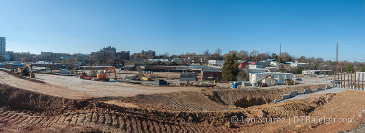
One day, I was riding south into downtown on Capital Boulevard and caught a glimpse to the west towards Glenwood South. The clearing of so many buildings just struck me and I had to come back to take some photos. This would have really been nice to have a drone for this post but either way the photo above attempts to show how much has been cleared.
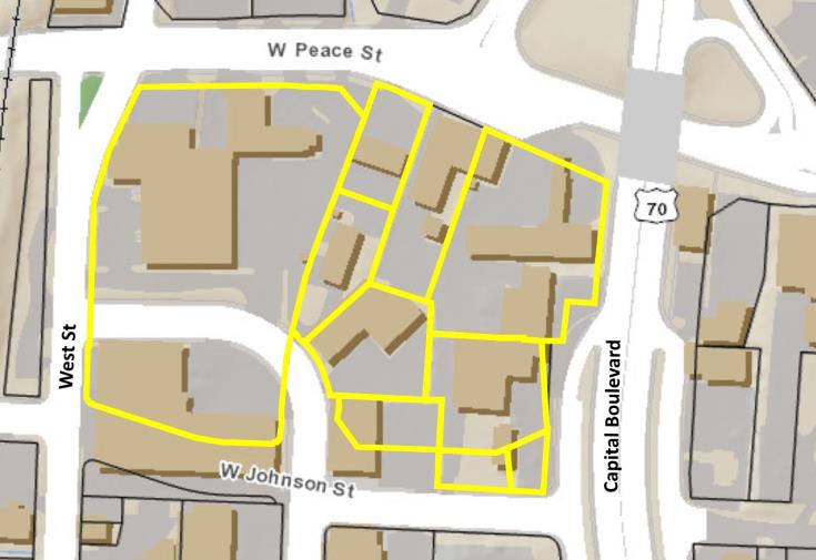
Between Johnson and Peace, Capital and West Streets almost all buildings have been demolished this year. With the help of iMaps, I estimate about 6.5 acres have been cleared in just this area.
History repeats itself?
Well, probably not. A residential neighborhood, the late Smoky Hollow, isn’t being cleared again but the state is still flexing its eminent domain muscle for highway improvements. Let’s hope this time it sticks.
Click for larger. Note the new Johnson Street connection already planned for. Next, the Harrington connection to Peace.
The photo is from the west side of Capital Boulevard with the new bridge over Peace Street directly to my right. I will probably not be able to get an exact after-shot once that project is complete but I’ll certainly try. (safely)
First to watch is the 12-story residential tower called Peace, formerly Smokey Hollow, at the corner of West and Peace Street. It was announced that a Publix grocery store would anchor the ground-floor space of this project. I bet that’s a huge selling point for more development in this area.
That’s all that’s confirmed at this time but I’m sure there will be more coming and with it all currently zoned for a maximum of 12-stories, an entirely new neighborhood (dare I say Smoky Hollow?) could be created with that kind of density. (by Raleigh standards anyway)
For more views, here’s a VR shot I took while up there. If you can’t see the embedded VR view, try seeing it directly on the blog.
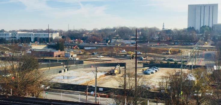
[UPDATE: 12-19-17, a RalCon reader has submitted a different view of the area from the 510 Glenwood building.]

Click for larger
Comments
Comments are disabled here. That's because we're all hanging out on the DTRaleigh Community, an online forum for passionate fans of the Oak City.


Almost a “any” city USA…
Thank you Leo for the great shots and update!
Agree with you I do…safety first!
Leo,
“Eminent domain muscle” is a little harsh here. Because of state funding, the ROW acquisition has to go through process set by Uniform Act. Plus, any flexing of power (i.e. implied getting property on the cheap) by State and City directly influenced the price of the City’s property being bought from the old Ops site.
The acquisition here was tricky and hats off to the folks at the NCDOT and City who waded through this one.
Thanks for the reporting, Todd
The reminder of Johnson being connected tells me that either a four way stop or traffic light will be needed at both the Johnson/West and Johnson/Glenwood intersections. It’s going to be the de facto entrance to the neighborhood for those coming south on Capital to Glenwood South in general, and the traffic will need to be better managed.
I hope Raleigh gets more projects like this. I absolutely love these designs. For those interested, these new Durham townhomes are going to sell from 400-700K, similar to what we see in Raleigh. http://www.heraldsun.com/news/business/article189653879.html
UPDATE. A reader has submitted a photo of the area looking east from the 510 Glenwood building.
It looks like a warzone now, but the progress from DOT has already been sneaky fast – i noticed new curb and gutter is in for new road location once they add median
N&O posted an article detailing the sale of 2 acres on Harrington St. For $10M for phase 2 of this Smokey Hollow transformation. I think this better illustrates the retail corridor image from an earlier post on Harrington people were curious about.
@Drew – Really hoping Kane pushes for higher zoning here. This area could EASILY become the true retail district (read: multiple blocks of continuous retail/restaurant, not the broken up, couple shops here, couple shops there like downtown proper has). With that, I could see a lot of people wanting to eventually live and work in this area, and allowing for taller buildings is going to obviously allow for more people to flock here. That, and it will help spread our skyline out much more than it ever will to the East.
That, and I feel like if the city doesn’t allow Kane to build his taller, more majestic developments here, he will just continue to save all the good stuff for North Hills (see: Tower 4. GOD how I wish that was a proposal for downtown. I could even see it on the N&O lot!)
@Jake: Truth be told, I’d rather have 12 floors and no surface parking lots than towers and surface parking lots. For DT, it’s all about the street level experience and I don’t see anyone complaining about Paris’ urbanity because most of the city is built around 5-7 stories tall. I am not against towers but they aren’t the be-all, end-all for me. I want street level experience.
@Drew: Can you link that story about the sale of the adjacent land? I couldn’t find it. Thanks!
Do skyscrapers and street level engagement have to be mutually exclusive? I’ve never understood the idea that it has to be one or the other. @John532, I’m not disagreeing with you at all, I want those things, but I also want some height. I love driving in to different cities from a distance and seeing a looming skyline ahead. IMO, 5-7 story buildings are a little boring to the eye, though I must admit they are certainly drivers of density, which is good.
Will, the way I see it is that the height isn’t the problem. It’s the maintenance and infrastructure that I have a problem with. Without some supporting transit then a taller building will result in more parking needs. Taller buildings generate more trash so a larger trash pickup bay is probably needed. A taller building probably needs a larger utility room on the ground floor, possibly eating into ground floor retail potential. That’s the kind of things that I might be against and prefer lots of 7 stories versus a few 30+s. There are always exceptions however.
Todd, I think that’s a process I’d love to understand but would have had to of been real close to the behind-the-scenes activities, which I’m sure you were or at least can speak the language. From an outsiders perspective, I stand behind my claim but don’t mean it to sound malicious.
I can only attend so many public meetings you know. ;)
Leo, we can discuss more over beer after one of those meetings. Maybe Lumley bike lane one in near future!!
http://www.newsobserver.com/news/business/article190412044.html
Another interesting thing I noticed in the article, the seller Sandreuter or the group behind 400h. I wonder if this will accelerate their build process.
I’ve made this comparison before and Leo mentioned it as well. The street level experience means more for pedestrians and foot traffic than the post card affect. No one spends the day in downtown Asheville and upon leaving says “I really wish they had taller buildings”
@ Drew
Cough cough…Actually I do, each and every time I visit…Lol
Though I do get your point, I believe that Ashville is more community than city, imho.
@Will. I understand that you enjoy looking at skylines while driving, and it would be nice to see an impressive skyline. However, the very idea that decisions about what we do downtown are even made based on driving sort of gets to the root of the tension between experience and (as Drew called it) the postcard effect.
I would also submit that the towers you want to see will come after we have created the sidewalk experience first. I know that everyone is panicked about running out of space to build towers but there’s nothing further from the truth. Look at Manhattan, they are building new towers all over the island and they have way less “room” than Raleigh does, relatively. Just because a building occupies a space downtown doesn’t mean that it can’t be replaced by another one in the future.
After watching MIami and Miami Beach go through a metamorphosis in the last 15 years, it’s very easy for me to see the foundation for a similar transformation of Raleigh in the next 15 years. The amazing projects under construction and on the very near horizon will truly transform the experience in much of DT and those experiences will, in turn, drive more demand that will likely result in towers. The next two years are going to be giant leap forward. That’s just my 2 cents.
@Drew, thanks for the link! This is big for Glenwood South.
@John532, I agree with your thoughts about towers replacing existing structures, and I hope that happens sooner rather than later. But FWIW, the “driving” comment had nothing to do with city planning being car-centric. I just meant it’s cool seeing a skyline from a distance, and usually, when I’m approaching a city from a distance, it’s in a car.
Speaking of street level experience (random comment coming!) I was walking in this area earlier this week and lamenting the lack of sidewalks in places there are none (north side of Lane between Dawson/Harrington, south side of North from Harrington to RR tracks, and West St from Peace to Tucker west side)…right in the middle of thinking “how in the hell…” I look up on West street and lo and behold, a new sidewalk is stretching south along West from Peace and is currently approaching Johnson St.
So random thought segways to…I have high hopes for the street level experience here. It’s been an anti pedestrian hole for the entire 30 years I’ve been in the area. It is a “hollow” anyway, so height won’t even appear prominent….my main concerns are that there be many many street level commercial spaces and I’d also prefer residential to office space, or at least something approaching a 50/50 split. I look forward to actual urban intersections at Johnson/Harrington, Johnson/West and Peace/Harrington. I also wish Pigeon House were cracked open and green banks and BMPs installed and a small stretch of greenway installed along its banks…If Peace were lifted up just a little bit above the creek, my imaginary greenway could have gone from Devereux Meadows, under Peace, along the daylighted creek and ended at the soon-to-be West St Cycle Way…this being an excellent way to connect folks through the City by dropping south into Dix via the West underpass at Union Station. Alas…no raising of Peace in my lifetime now….