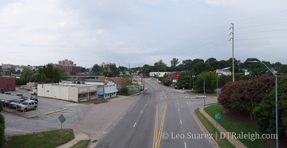
Looking West down Peace Street, August 2016
What would it take for a Raleigh neighborhood of the 1900s that was completely wiped out, literally paved over, to come back? It seems naming a new development in the 2000s after it would be a start.
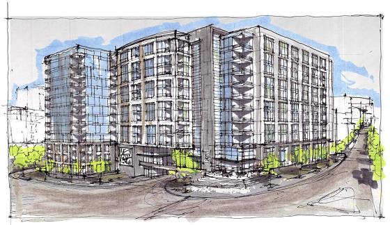
The Smokey Hollow project will be a 12-story mixed-use project with 400 (400+ actually) apartments and retail according to the press release and recently submitted site plans. The press release doesn’t call out the name Smokey Hollow but the site plans on the city’s website are named just that.
A quick aside, I’m hung up on the spelling for some reason but to the best of my knowledge, the name of the neighborhood that was in this area of downtown Raleigh was Smoky Hollow (smells like smoke) and not Smokey Hollow. (the proper name of Smokey) As of this writing, Smokey Hollow will be the new development that is planned and Smoky Hollow will be the neighborhood that once existed in this area of Raleigh. (I’ve also tweaked previous posts to try and be consistent)
Now that I’ve got that out of my system, I’d like to dive back into the history of the area and how Smoky Hollow was cleared out by the State of North Carolina and their drive for what was called “urban renewal” in the 1950s and 1960s.
As part of a former project (Link Peace Street) that I was a part of, active in 2012, I have polished off this Google Map for reuse. Below is the map containing the old Smoky Hollow boundaries as well as former streets. There are also historic and present day photos.
As for the history of the neighborhood, Anna at her blog Reinvent Your Wheel has a great take on the area’s change in her blog post, “Capital Blvd: Raleigh’s Great Divide.” I’m posting a piece of the post with permission.
Smoky Hollow (which I’ve also seen spelled as “Smokey” Hollow) was a blue-collar neighborhood in downtown Raleigh prior to the construction of Capital Blvd in the 1950s. Everything I’ve found hints the it was a racially mixed area with both black and white residents which would have been somewhat unique to that time period. Its boundaries were roughly Peace St to the north, West St to the west, North St to the south and Wilmington St to the east. The residents of Smoky Hollow worked primarily for the railroad, mill, or other industrial businesses in the vicinity.
Children growing up in Smoky Hollow entertained themselves by playing on the train trestles and in the Pigeon House Branch creek, which has now been mostly buried. It was a solid community although it seems like it was considered to have been a little rough around the edges. The construction of Capital Blvd, with the addition of other projects, brought about the end this unique piece of downtown by the early 1960s when almost all the residents were forces to relocate. Only a few pieces of the Smoky Hollow neighborhood remain, including Finch’s Diner on Peace St and the store fronts found to the west of it.
*Capital Blvd: Raleigh’s Great Divide
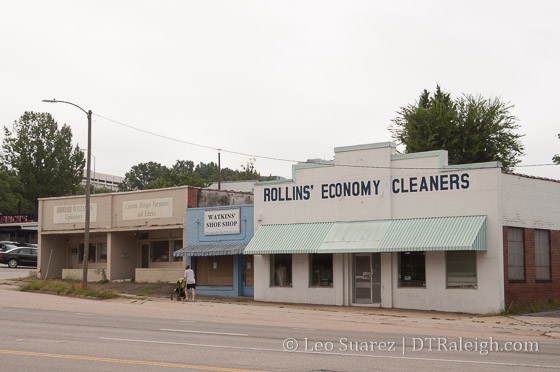
Old storefronts along Peace Street, August 2016
Anna’s post also has a pair of maps, showing the before and after effects of Capital Boulevard punching through the Smoky Hollow neighborhood. In short, a grid of streets was removed resulting in two anti-urban hits to downtown Raleigh; a fast moving highway and the state government complex.
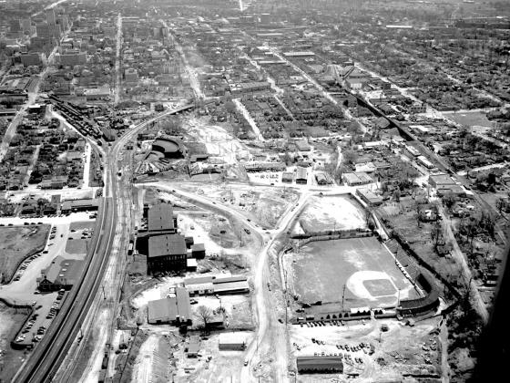
A neighborhood faded away as well as a baseball park. The Devereux Meadow ballpark, which has been mentioned on this blog before, predates capital boulevard, as shown in this 1952 aerial photo taken by the News & Observer.
Reprinted with permission from The News & Observer. Click for larger.
This photo shows Capital Boulevard (then known as Downtown Boulevard) under construction in 1952 or so. The project was finished in 1953. The view is looking south. This photo shows the intersection of Peace Street and Capital Boulevard. The ramps for the bridge have been graded. Devereux Meadow ballpark is in the foreground and across the left field fence is the Raleigh Cotton Mill. Across the railroad tracks from the mill is the Seaboard Passenger station. In the center is the Seaboard half-roundhouse adjacent to the rail yards. To the right of the roundhouse is Finch’s with cars parked in front. To the right of Finch’s is a collection of storefronts including the dry cleaning building. These are among only a handful of buildings still standing in the former Smoky Hollow neighborhood. At the right, you can see the Norfolk Southern tracks and trestles including the one that passes over Peace Street. The boundaries of Smoky Hollow were basically that area between the Seaboard railroad yards and the Norfolk Southern Railroad tracks, and between North and Peace streets.
*Historical research by Karl Larson, History Editor, Goodnight Raleigh.
Let me add that you can still see some of the Smoky Hollow houses along West and Harrington Street.
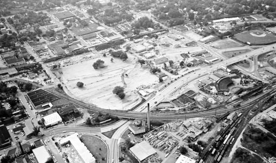
The finished product can be seen below in this November 1964 photo, again from the News & Observer. The neighborhood is gone at this point.
Reprinted with permission from The News & Observer. Click for larger.
Over time, the area has filled in, mostly with state and county-owned properties. Economic development? I’m not convinced that was a successful result of the Capital Boulevard project of the 1960s.
Moving to the present, the original area of Smoky Hollow hasn’t seen any real movement lately except for the West at North tower. Located at, you guessed it, West and North Street the 17-story residential building opened in 2008 and is probably the anchor to any West Street activity near Glenwood South.
With a lot coming to West Street, the announcement of the Smokey Hollow project, artist’s sketch below, shows that we may be putting the pieces in place to bring back residential to Smoky Hollow once again.
Smokey Hollow, planned for the corner of Peace and West Street. Click for larger
It may not look the same as 75 years ago but the Smoky Hollow of the future may exist in mid-rise apartments with ground floor retail.
In a future post, let’s take a look at some of the factors supporting this residential drive in Smoky Hollow. The pieces are all there including a creek, a new park, and calmer, better connected streets.
Comments
Comments are disabled here. That's because we're all hanging out on the DTRaleigh Community, an online forum for passionate fans of the Oak City.

Great research here, interesting stuff
This is exciting! A water feature would greatly improve our city!
Ever since I went under contract for a condo in The Cotton Mill during the pre-renovation sales, I have been impatiently waiting for something to happen to the neighborhood. It’s been more than 20 years since then and I am so excited to see things begin to happen: even if it doesn’t include completely removing the Capital Blvd. bridge over Peace St.
I am hopeful that the actual transformation of the neighborhood won’t take another 20+ years to become viable. My hope is that the Smok(e)y Hollow project will jump start and accelerate its transformation. I can see an anchor grocer igniting periphery investment in the immediate neighborhood. …keeping my fingers crossed that all goes well.
My opinion.. this area and warehouse… are both area’s of biggest potential!
There are a ton of little tidbits seen in the aerial photos I could ramble on about, but off the top of my head…it looks like you can see the second roundhouse still (there were two on the north side and one on the south side IIRC)….its near where the tracks dead end at Salisbury St, and is part of the “machine shops” complex that you can easily see on 1914 Sanborn maps. Also 5, of Raleigh’s 6 textile mills are still standing…the one not standing today can be seen here …if you look to the left of the half round house there is a bright white (dirt) road that is technically an extension of McDowell St that no longer exists. At the southern tip of that extension where it hits the tracks is a rectangular brick building that is the Martin Mill…it is about the size of the main block of the Melrose Mill (that Babylon is in). Martin Mill sat right where the very brutalist State parking deck is just west of the Archdale Building on Salisbury St. The machine shops were about where the visitor parking deck on Salisbury St is. The half roundhouse pit and spinning mechanism are still just off the dirt extension of Johnson St east of Capital Blvd.
great article & research Leo. I have one the City’s info sheets from the 60’s on the revitalization of the smokey hollow. It has some great pictures and Jesse Helms was on the council then. You will not recognize the area in five years. Hopefully they won’t over commercialize it and run out the smaller independent shops for a CVS.
@bc unfortunately, you know that is exactly what is going to happen. Look at what’s becoming of Hillsborough St… I think Kane is a great developer for North Hills but I am cautiously optimistic about his downtown developments because I am afraid they will follow North Hills’ lead and become incredibly commercialized buildings. Just look to his NC State student apt building on Hillsbro – CVS, IHOP, and some crappy chain pizza place. Oh and there’s still room for one more restaurant. Crossing my fingers for a Chili’s (sarcasm)
@jake. The Dillon.. which is a kane project looks pretty amazing! He is doing a great job of keeping the old ware house face and adding to it.. with a somewhat unique building. Looks awesome
I’m not Kane’s biggest fan (he hosted Trump recently), his success with North Hills is nothing short of amazing. He also seems to know will work in a given area. North Hills is upscale. His Hillsborough St projects cater to college kids. CVS, IHOP, and pizza work there; a boutique bow tie store or an upscale salon would not. He has a proven record of building pretty solid, successful stuff, so I’m pretty optimistic about him finally getting into downtown (like I wished he had from the beginning, but again… knowing what will work – and when).
I am perplexed by the anti-CVS kick. Frankly, a good urban neighborhood needs these resources and, spoiler alert, almost every single thriving urban neighborhood has a chain pharmacy, a chain grocer and a host of other chain businesses. It’s a simple reality of today. We can all live in our dreams if we think that DT Raleigh is going to turn into Portland, Oregon of 25 years ago or something like that. Anchor chains simply make retail viable in today’s world. Substantial retail will not happen in DT Raleigh unless it’s motivated by the foot traffic that the anchor chains provide. This is why every single strip center developer in the nation wants a grocer and a pharmacy in their centers.
IMO, what we should be pushing for is developments like Smokey Hollow to also include much smaller retail spaces to augment the grocer and larger chain stores. Smaller suites enable small independent business people to take the plunge and infuse the retail scene with more local identity. The sort of size I am talking about is like the wine shop on Glenwood that’s in the Hampton Inn & Suites building. If the Smokey Hollow retail space is only subdivided into larger parcels, then we’ll only be left with the national chains that can afford the space.
Chains that I would actually like to see come to DT include: Crate&Barrel, Apple, Guasaca (local chain!), Mami Nora (local chain!), boutique Target, H&M, Urban Outfitters, Haagen-Dazs, and Regal Cinema.
@john – Yes I agree! CVS is a good thing. The only one we have dt is the oldest one in america that is open 2 hours a day or something. Yes, if you visit San Fran or other large cities . they have CVS all over the place… which is very convenient when need be. I think any of those large chains to anchor buildings are much needed.
@Jeff – at least Kane is coming to Raleigh and investing vs empty lots of nothing or one story buildings, etc. I personally would love to see a bit more unique buildings in North Hills, however, I think he has done a great job of transforming that area! He has built somewhat tall buildings which has provided space for businesses, residential as well as large restaurants and retail. I think its pretty cool driving through there.. actually has a city feel with the taller buildings.
Side note: I see the are completing a parking lot for Glenwood Place? Is this serious? So does that mean Glenwood Place is here to stay? That parking space could have been used in so many other better ways vs a one level parking lot. That does not benefit Glenwood South at all.
I think York does a better job leasing Cameron Village with unique and some locally owned stores than Kane does with NH. I choose to think of the Kane downtown stuff as foundational/anchor stuff, and then *hope* that the resulting push to class A prices doesn’t push out the stuff that makes/made downtown interesting in the first place. The gentrification is indeed happening (loss of band space e.g.) and the question is now will it stop at what I think of as the good level of change, where old buildings get rehabbed, and well run local places dominate or does it push on past to like you’re seeing in five points east where all the original houses get replaced with larger houses (“oh look honey what a cute neighborhood…lets tear down a piece of what made it cute and move there”) represented by projects like Edison/Highwoods going to take out a row of 1870’s storefronts on Wilmington St,301 Hillsborough potentially taking out the Hicks mansion, the 100 year old houses torn down over by old IHOP (2 by FMW and one by Farmhouse) etc etc. Raleigh has areas that have bunkered in and protected themselves (Oakwood, Boylan Heights) but many other areas are left to the wolves. There are many good rehab projects happening as Leo has shown us, but I am for a tighter grip on thinking things through to the extent regs allow especially when it comes to tearing down old things and how new things, even on parking lots, can raise prices to the point that it puts even more pressure on tearing down old things.
My father talks about going to see games at The Devereux Meadow ballpark all the time.
So would the “water feature” be a river walk similar to the one in San Antonio? Or would they be just be creating a stream through a large green field with trees.. or a mix of both? I think the way West St over looks that area.. it would be a great spot for some nice restaurants and bars to have balconies over looking it or patios next to it.
Always a good conversation. Thank you Leo, for this post. Neighborhood anchors are important and vibrant neighborhoods typically have a few. Cameron Village has a good mix of national and local establishments. I trust that Kane is paying attention to the mix in his downtown developments but will definitely want the income that an anchor can bring in.
I hate to bring up the whole “Raleigh vs. Charlotte” discussion, but I think something like Charlotte’s Sugar Creek greenway would be a good starting point for a downtown water feature. Another example would be Waller Creek in downtown Austin.
@ Greg, you’re good man. We’re just discussing “stuff” and not “vs”. Sugar Creek’s opening up was largely a cheaper cost attempt to reduce nutrient loading in waterways that City WWTP’s ultimately discharge to. If they can’t get the loading down enough, then eventually there’ll be expensive upgrades needed at the WWTP’s as the increases. Waterbodies are calculated to have a total maximum daily load of nutrients to maintain their aquatic life support characteristics. The public selling point on these projects is “look what a pretty greenspace!” It’s not incorrect…it is a pretty greenspace…note, that this is exactly how Deveraux Meadows and the Crabtree Blvd park stuff is being presented. The public doesn’t know pounds of nitrogen, but it does know walking paths, and picnic tables. I for one, would love to see Peace raised up a tad (it dips at the creek anyway…wouldn’t be a stretch at all), and a Devereux Meadows trail extended under Peace, ring the Smokey Hollow project and stairs up onto West St.
@Mark: Interesting idea to raise streets. I am actually living through that right now in MIami Beach where the city is lifting infrastructure (roads, sidewalks, parks, sea walls) up 3 ft due to its low lying elevation + sea level rise and flooding. It’s no easy task but it has to be done.
In Raleigh, I’d also love to see some sort of access from the park to the “Glenwood Green” that doesn’t involve crossing the street and raising the street could make that happen. There are underpass trails on the greenway in other parts of the city already so that idea is not without precedent.
It looks like the new Harrington extension will be tied into Peace right near the creek location. From this map I found online: http://en-us.topographic-map.com/places/Raleigh-677582/ , it looks like there’s a ten foot drop between West and Peace and the creek and Peace. The only problem with raising Peace at this point is that the Capital bridge over Peace would also have to be raised and that would require redesign that is unlikely to happen at this point.
I am all for green space as well.. but do you think with Moore Square, Nash Square, Fletcher park and Dorthea Dix (just to name a few)… we need another dedicated “green space”? I see Dix as being Raleigh Central Park.. its huge.. plenty of green space and streams. Fletcher Park, which is just one block away already had plenty of green space. I think it would be a big miss if we didn’t use this waterway as riverwalk like in san antonio. With businesses, restaurants, and retail.. and a nice water feature going through them. A place to sit out and have a drink or meal and enjoy the water going by. Maybe I am the only one that thinks this way. But to me.. putting all the time and money into just having a stream through a field with some trees.. so you can ride your bike or run.. doesn’t make sense. We can have that in Dix park, or there are plenty of them in Holly Springs or Apex.
@Mark: After playing with the map linked above, it appears that there is some wiggle room. Peace at the creek appears to be about 9 feet lower than Peace at the current underpass of Capital. So, if it was lifted 9 feet, it wouldn’t necessarily require a new bridge design.
Then we could have access from the north side to the park without crossing Peace. It would, however, require a short bridge on Peace which would cost $$$. That said, I think it’s worth trying. The underpass trail could come up directly to the sidewalk at the new Harrington St. extension.
Oops! I meant access form the south side of Peace to the park (on the north side).
Steps… wheelchairs? Interesting Idea
@Bob148: I agree with you but the city won’t build on that land because it’s a flood plain. That’s why it’s going to green space instead that’s being billed as a limited resource park. It’s really primarily a flood plain that you can use to walk you dog and play frisbee.
As for Dix, I see it as a great park resource for the city but I don’t see it as a central park because, frankly, it’s not central. It’s DT adjacent but it has almost zero credentials an urban park. You can’t walk to it from the core. It’s separated by a major thoroughfare: Western Blvd on its north side and by a giant prison complex and the Governor Morehead School complex across the street. Arguably the existing Pullen Park has more urban access credentials because you can actually easily walk to it from the far western side of the city’s DT boundary.
So, given that the city doesn’t and won’t really have a central park that’s walkable to its residents, a rhythm of small district parks makes the most sense and the revitalization of the former Devereux Meadows as such a park is welcomed. I’d also like to see Caswell Square reinstated either partially of fully.
@john. good points. I see what you mean about dix. I suppose I was thinking further out when s saunders becomes more developed and downtown moves further south as well. But I see what you mean regarding other places around.
What do you think of West Street over looking the “riverwalk” for businesses, restaurants, bars, residential above retail, etc. That would provide amazing views of downtown and you would be next to the water and “green space”. Once Kane builds at peace and west.. I can see that section of west across peace on the north side as being one of the most ideal places
Not sure exactly what is considered the flood plain.. but there are existing buildings there now? Are they in it?
@bob148: I salivate over the idea of developing the north end of West St. above the future park! If I were rich, that’s the land that I’d be assembling. With Flythe on its way out, I’d be gobbling up that corner and moving my way northward. Oh….it’s but a dream. sigh…..
I completely agree with the potential of that “hill” and would love to see it developed as dining and entertainment. The views alone would pack the businesses for sunset cocktails or romantic dinners al fresco. Even just a coupe of levels of condos above lower level business would allow enough height for unobstructed views to the skyline for, perhaps, ever!
I am not sure that there is enough physical relationship between that hill and the creek below to really make the connection to the water in the way that San Antonio does but I fully agree that this area is begging for some serious development consideration. There’s just so much potential there.
I live nearby, and at 12 stories, the Smokey Hollow building is 8 stories too tall. It’s too close to an existing residential neighborhood to have that many stories, and any businesses further north on West Street won’t have skyline views unless they are much further north. There shouldn’t be another West at North scale building in that location.
Does anyone have a aerial rendering of what the river walk would look like fully completed/running through downtown (visual would help)?
Thx
John, did you account for the creek bottom being about 6 feet or so below the current road support structure/top of culvert? I was thinking only like a 4 foot higher elevation of the Peace road surface would provide enough clearance underneath.
Bob as far as greenspace vs. water feature, in my mind they weren’t all that different. Build the path on a [hydraulic] bench, between the bench and the creek is a small slope with a ‘top of bank’ engineered in, and fill that with plants, native if possible (river birch, muhly grass etc). The bench would have to have a retaining wall that holds up the Smokey Hollow parking lots and patios ands stuff. The space between the creek and Harrington’s realignment I think can have a larger planted strip that might be able to function as stormwater BMPs as well.
I hear that Fayetteville is getting its own minor league baseball team…how I hate the 30 mile rule…
@ Robert , Talks are still going on with Raleigh leaders on a possible Raleigh / Atlantic League Baseball Team . Being a independent league , they are not governed by the 35 mile rule. They play @ the AA level . Over 800 league players have signed MLB contracts for between $500,000 to $48 million in the last 4 years . St. Paul , Minn stadium is only 13 miles from The Twins Stadium & St. Paul sold out every home game last season , 8,100 fans . Sugar Lake , Tx. stadium is 25 miles from The Astros stadium & Sugar Land is having 5,200 to 6,300 fans almost every game . Fingers crossed on Raleigh baseball Robert !
Whether it’s the Mudcat’s or a AA team, this downtown Raleigh baseball stadium needs to be a Class “A” signature stadium (at least on the level of the Bulls stadium (but better), but with retail and restaurants incorporated at ground/street level around the stadium – need it to be very sidewalk friendly – no blank walls). If initially a AA team, that is fine, but build the stadium as if the Mudcat’s will be playing in it in the future (will be an easy transition next level standards). This 30 mile rule is pathetic. I go to a Bulls game once every 3 years (thus, Mudcat’s are losing my business due to being in Zebulon). Would go to Mudcat’s games frequently (with my girls)if they were downtown.
Canes, Mudcat’s (or AA) State and other teams playing in downtown stadiums would be amazing (especially with all the great taverns, restaurants and clubs in downtown Raleigh – would make for a great sports evening year round)
@ Anthony , Part of the baseball presentation to the city covers everything that you have mention . “Go Raleigh Baseball ” !
@IliveInTheHood, I hear what you are saying but I am not sure that the Smokey Hollow project is going to kill DT views. I was just looking at the map after reading your comment and it appears to me that the project will be far enough west to not block the view from the top of the West St. “hill” north of Peace. The closer one is to Peace on the north side, the more impact it will have on the view of course, since it will be directly across the street.
Regarding the comparison to the West building, keep in mind that West is both taller than the proposed Smokey Hollow project (I think by 4 floors) and sits at about 30-50 feet higher in topographic elevation based on pinpointing elevations on this site: http://en-us.topographic-map.com/places/Raleigh-677582/ . In the end, from the top of the West St. hill, Smokey Hollow may appear 70-90 lower than the West building.
The bigger concern for the view will come in how inside the square loop is developed. If it’s equally tall as Smokey Hollow, it may impact. I’d love to see all of the scenarios modeled.
@ John and @ ILiveInTheHood, I was also going to say what John did…there are absolutely no houses near here now. Brooklyn/Glenwood is way up on a hill and will easily see over this building which sits adjacent to the Pigeon House Branch channel. I am very much an advocate of proper scale and transitioning heights etc, but I think when the arguing points you’re stating are used in places they don’t apply very well, the pro-height people and growth-at-all-costs people start to discount these arguments every time they hear them. So with all due respect, please make sure you’re supporting arguments are strong in a particular case…you are of course entitled to just not wanting a midrise (for me mid = 4-12) building there, which is fine. And FWIW I lived on Hinsdale St for several years and also could now be considered to live in the “hood” on the east side so our actual perspective on downtown is likely been similar.
Hi! Long time Raleigh native here to let you know that I am opening a new retail location (vintage furniture…mostly from the time period of the original Smokey Hollow neighborhood!)on West. St. right next to the Southland Ballroom/Themeworks building. I never knew about the Smoky Hollow Neighborhood that was around this area (though I did go to Finch’s every day before pre-school with my grandfather) and have loved reading your article. Let’s hope we can survive this construction because I do truly believe that West St. has great potential and history and is an important part of the Downtown Raleigh Landscape. Can’t wait to see this area flip!
Hi Evie! My wife and I ran by there last night and noticed the cool mural and the upcoming new business (and an awesome pug inside)! We were talking about how that area seems poised for some great things. Glad you’re going to be a part of it!
Welcome Evie!
Given that you have recently set up shop in the neighborhood, did you gain any insight into the realignment of the Johnson St from West to Harrington? Some plans show that, when Harrington is realigned to Peace that Johnson will connect through the current location of Southland and ThemeWorks (or as I like to say The Me Works…but I digress). Do you know any details? Are you in that actual building or in one nearby?