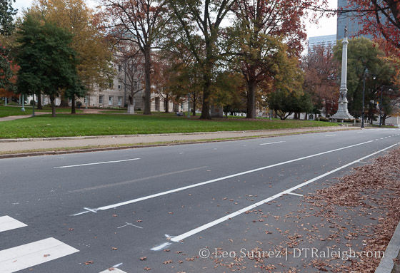
Fresh paint on Hillsborough Street.
In mid 2014, I did a post about the evolution of Raleigh’s bicycle network. It’s been years, it feels slow-moving, but the pieces may be starting to connect and create this thing called a “Network”. I got really into looking at the maps in the latest draft chapter of the Raleigh Bike Plan Update. The complete document should be done before the end of the year and some of the material is available now.
Dive in to the Raleigh Bike Plan Update.
Looking at Chapter 3 shows the recommended network. It includes 126 new miles of greenway, 149 miles of new protected bikeways, and 277 miles of new bike lanes. The full breakdown is in the below table.

It’s great to see so little sharrows being planned as, in my opinion, they don’t do very much. The recommendation is for more than three times more miles of bike facilities versus what we currently have. That’s a big ramp up in expanding the “Network.”
Protected bikeways are a huge step in the right direction to get riders on to the network. A protected bikeway is described as such:
This plan update defines a protected bikeway as a bicycle facility that is physically separated from motor vehicle traffic within a street corridor. For this Plan, this includes cycle tracks and buffered bike lanes, in addition to the City’s shared-use path and greenway network. The on-road physical separation can be achieved through parked cars, curbs, medians, bollards/traffic posts, planters, or marked buffered space between the bike lane and adjacent travel lane.
The one catch that I don’t like about greenways is that they have, historically, been seen as recreational paths versus effective transit routes. In only a certain amount of cases does a greenway help someone get from point A to B faster than a street.
Speaking of Point A to B, the chapter shows us the recommended network on a map of Raleigh. I decided to take a look at five possible routes starting from downtown Raleigh and seeing how the bicycle network of the future would accommodate versus today.
I have a deep hope that the Raleigh of the near future can make all of inside-the-beltline a bikeable haven for residents to easily zip around on. The network should get folks from their homes to any major destination easily.
I’ve included a doctored-up screenshot of those maps with each route.
Downtown Raleigh to North Hills
From one urban center to another, getting to North Hills and back by bicycle would be a fantastic way to move around. Today, the greenways are just too far away and don’t provide a direct enough route. With Capital Boulevard being a huge east/west barrier, getting to St. Mary’s Street is the best option. Heading North, the ride should cross over to Lassiter Mill Road where it will take you to North Hills.
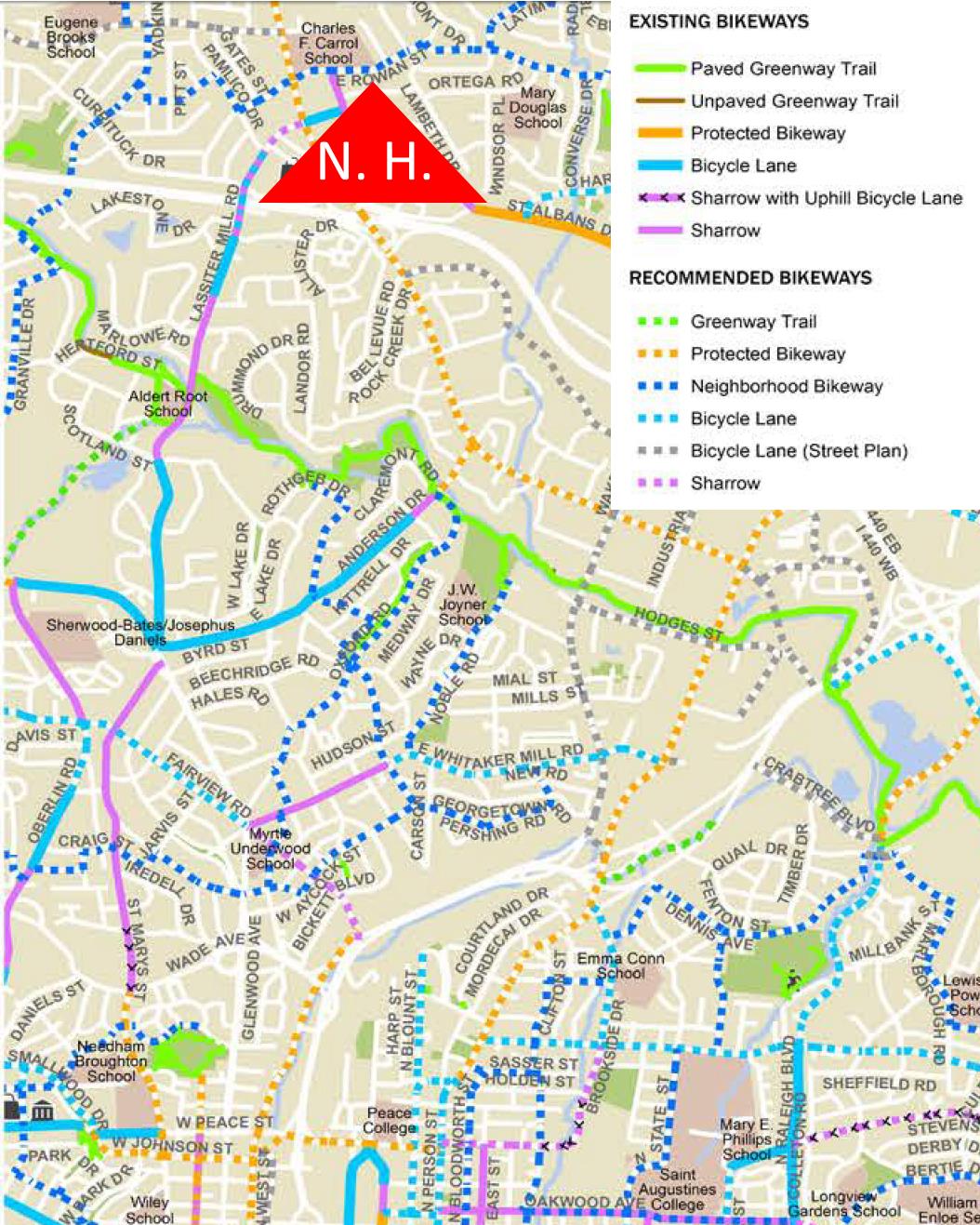
Click for larger
Currently, both of these roads have bike lanes and sharrows for almost the entire route with some sections unmarked. According to the draft plan, a new protected bikeway would go in starting north of Peace Street but wouldn’t be that long. (up to Wade) Along with some new sharrows on Lassiter Mill Road, there’s not much improvement on this route.
Downtown Raleigh to Five Points
The closest two destinations in this list, getting to Five Points is pretty much a ride up Glenwood Avenue. Today, there are no bicycle facilities between Five Points and Glenwood South. The two-lane road isn’t so difficult but that does mean you need to be comfortable riding in traffic.
Sadly, the recommended network has nothing planned for Glenwood Avenue here. Instead, a new route will go in along West Street. A protected bikeway/greenway trail, which we’ve covered before, is recommended form the Warehouse District all the way to Wade Avenue. The route will split with a greenway going northeast along Capital and sharrows along Fairview Road. That will lead you straight into Five Points.

Click for larger
This will be a great north/south connection and I’m interested to see if it’s possible to add a connection, somehow, to this greenway along Capital Boulevard from the eastern neighborhoods, like Mordecai and Oakwood.
Downtown Raleigh to Crabtree Valley Mall
Ride to the mall? It’s probably better to just take the bus. Route 6 is a direct shot from downtown Raleigh to Crabtree Valley Mall. You can’t get more convenient then that. Still, riding your bike adds a little freedom. I’ve done this once with the intent to get some exercise and do some shopping. It’s not for every day though but maybe it is for some.
Today, Glenwood Avenue towards Crabtree is pretty hectic and there are some bike lanes but only for a small portion of the route. The recommended network adds protected bike lanes north of Glenwood/Oberlin. Taking the route to Five Points would be how you start. You then would most likely continue north on Fairview, get to Oberlin where bike lanes exist today, and take Glenwood north on the new protected bike lanes.
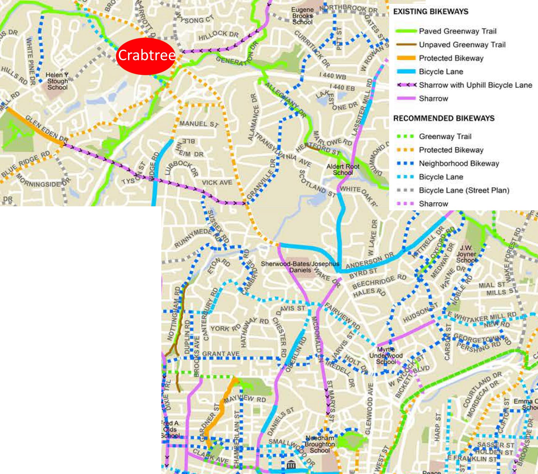
Click for larger
This is a big improvement. The challenge though is pulling into Crabtree Mall once you are there. It would be fantastic to see the spaghetti bowl in that area cleaned up but an easy fix might be a bicycle “off ramp” onto the greenway that goes underneath Glenwood Avenue and goes to the Crabtree Valley Avenue entrance.
Downtown Raleigh to the Fairgrounds
Hillsborough Street is so direct, so straight that using it for cycling transit would be really tempting when going west. Up until just this week, we now have bike lanes starting from the Capital building mostly going up until NC State University. Currently, it then fades out for now but the two lanes west of Faircloth Street might makes things manageable for biking without any lanes.
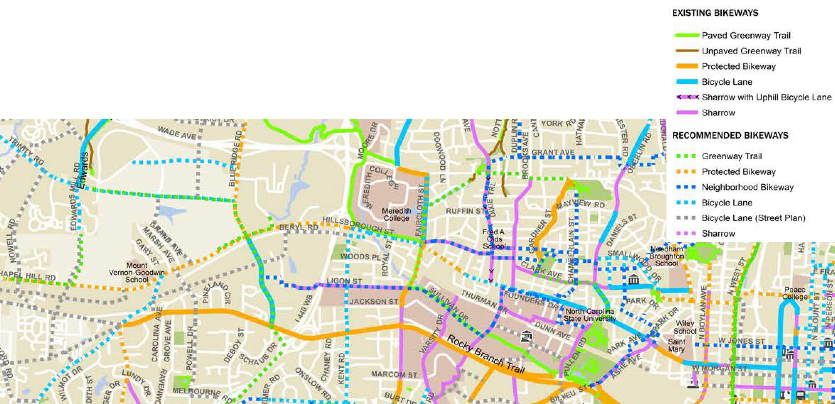
Click for larger
The recommended network continues the bike lanes in front of the university and uses a combination of protected (mostly) and bike lanes to get to the fairgrounds. The plan is actually to extend them all the way out to I-40.
This is a huge improvement for connecting to West Raleigh.
Downtown Raleigh to the Farmer’s Market
Today, getting to the Farmer’s Market by bicycle isn’t the mot difficult as you have a few options. The longer but safest route is by greenway but a few residential streets could get you out there faster without the need for bicycle facilities. Still, a straight shot would be most ideal and that most likely means that Lake Wheeler Road needs a makeover.
Click for larger
It is great to see a protected bike lane on the recommended draft map between the Farmer’s Market and downtown Raleigh along Lake Wheeler. A protected lane is probably best as Lake Wheeler has some nice hills and is pretty direct.
Great improvement here.
Wrap Up
For me, connecting major destinations together in a more direct route is what I’m looking for in bicycle improvements. Since this is a downtown Raleigh blog, that’s the approach I took in these five routes.
As always, the draft bicycle plan is still a work in progress and you can submit feedback on what you see up there.
Comments
Comments are disabled here. That's because we're all hanging out on the DTRaleigh Community, an online forum for passionate fans of the Oak City.
@leo In regards to crabtree mall… they are suppose to be building a pedestrian bridge across Glenwood ave… from the mall to a new shopping center beside the Marriott! My hopes would be that they include bike access to that bridge as well. This would help skip some of the traffic congestion.
The addition of the bike lanes downtown is great but has created continuity issues, which are noticeable when traveling through intersections where the lanes sometimes jog rather abruptly between blocks. I’ve already had someone cross over into my lane due to this – it’s tough to track where each lane is going if you’re not paying attention.
Hopefully this will be addressed sometime in the future to create a more concise striping vs. what appears to have been hastily done.
Bidclerk is showing two large Multi-Residential Projects for Raleigh , one is $67 million , app. start date June 2017 , & the other $40 million app. start date August 2016 .
Love the new changes on Hillsborough and Salisbury, traffic last night was a bit chaotic on Hillsborough, I took the dog for a walk and noticed all kinds of confusion on what lanes to use by those in cars. It looks like the city did not change the overhead lane signs to match the new patterns. Kudos to the overall increase in bike lanes
Really impressed with the detail of the Bike Plan especially attention to goals, existing conditions, and plans for many corridors throughout the city. I hope that the Transit Plan is as detailed.
I would like to see at least some attention paid to connections beyond the city, throughout Wake County, the Triangle and larger projects like the Mountains-to-Sea Trail. I also look forward to what bike share can do for biking in Raleigh. I recently used CitiBike in NY and it was great.
Love the Neuse Greenway Trail ! Our son & myself parked @ The Buffaloe Rd./ Aqulatic Pool Park & rode to The Falls Dam & back , app. 30 miles . The next day , we parked @ the same place & rode to Clayton & back , app. 50 miles . Very pretty area , great ride !
Just drove down Hillsborough St and while I love the new changes, it was a bit confusing. I wish they’d just paint the bike lanes so it’s more obvious to drivers. Any idea why they don’t do this?
Lou, I’ve asked the city this. Especially for a solid green lane through the intersection. They dislike the maintenance aspect of it (paint fading). Other cities have solid painted lanes and it definitely increases driver awareness of the lane! Our city is just scared to adopt new ideas unless they are tested, studied, re-studied, etc..
I don’t get why they just can’t plan to touch up or repaint them every 2 years or so.
Chaos on Hillsborough again this morning, its more dangerous than before for pedestrians. Green paint would help a ton.
Any pictures of these new lanes?
Great to see this but the maps need some work graphically.
The lack of visual hierarchy with colors or line-weights makes it difficult to quickly discern the primary routes. The pink sharrow routes read as prominent or more so than the protected or greenway routes.
There’s also some discontinuity from sector to sector. There is a greenway route shown adjacent to Capital Blvd on the Southeast sector and Downtown Zoom, but it is not shown on the East sector where it should continue.
CX, here’s a photo I put on Instagram of the lanes on Hillsborough Street. https://www.instagram.com/p/-riXP_N9tI/?taken-by=dtraleigh
Let me add a little more to this post. Jump on over to BikeRaleigh.org and read a post written by our city’s Transportation Planning Manager, Eric Lamb.
http://bikeraleigh.org/home/index.php/blogbike/331-bicycle-friendly-community-2015
The planning team seems disappointed after getting a repeat Bronze level. The report card is here, http://bikeraleigh.org/home/images/PDF/BFC_Fall_2015_ReportCard_RaleighNC.pdf
Lots of interesting facts on it. The most important point to note, I think, is the number of riders and number of crashes/fatalities. Our ridership is 0.6%. (2640 riders with a population of 439,896) We can use that number to calculate the number of crashes (174) and fatalities. (2)
I can’t think of any aspect of a city that can’t grow without being safe first. Bike lanes are nice but we need to always strive for zero deaths and a huge reduction in crashes. After this is solved, you’ll see biking ridership increase naturally.
Does anyone know how the NCDOT meeting went a couple of weeks ago where they were going to discuss recommendations for HB 232? HB 232 is supposed to update bicycling laws in the state and they were discussing some pretty important safety issues such as “Whether bicyclists on a roadway should be required to ride single file or
14 allowed to ride two or more abreast.” The fact the the NCDOT is even debating this is mind boggling and apparently they hadn’t made a decision on that piece prior to the meeting on 11/18.
http://www.ncleg.net/gascripts/BillLookUp/BillLookUp.pl?BillID=H232&Session=2015
@Leo – The recommended “Neighborhood Bikeway” on Dixie between Wade and Hillsborough was just completed. I haven’t biked it yet, but the new street markings have definitely slowed vehicle speeds; which I think is good given Lacy Elementary is right there.
Daniel , The planning commission paperwork for February 2015 shows The Residence Inn @ 10 stories , 130 feet high .
Thanks so much for this great write up, Leo! Very thorough and I love how you broke it down by neighborhood.