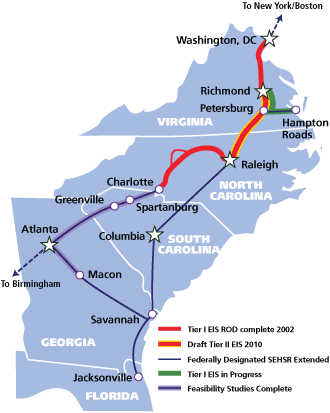
We’re crawling along slowly on this high-speed rail thing. The Tier II Draft Environmental Impact Statement (DEIS) of the Southeast Hish Speed Rail Corridor is now available for public comment. This particular statement focuses on the section of rail lines that will run from Raleigh to Richmond, Virginia. From SEHSR.org:
This Tier II DEIS evaluates detailed study alternatives within this preferred corridor between Richmond and Raleigh In the Tier II DEIS, the project corridor is divided into 26 sections. There are three alternatives in each section, and each rail alternative includes an associated set of highway improvements.
The point of this public comment period is for everyone living in the affected counties to look at the proposed rail paths and provide feedback to the planners. There are open events along the route throughout July. Most RalCon readers will probably be concerned with the Wake County event, which is on Monday July 26th, from 5-7pm. As always, the SEHSR website is always up and open for comments from now until August 30th. Maps are available for each section from here to Richmond with the proposed plans for the rail line.
The route in Raleigh starts at the Boylan Wye in the warehouse district. The maps showing this are available on the SEHSR site here. There are two proposals that show very different paths for trains heading north out of the wye and I’d like to focus on those in this post.
There’s good additional reading from Bruce Siceloff, who sums it up nicely with this piece in the N&O. Siceloff writes:
Should the trains follow Norfolk Southern tracks north from Jones Street along the west side of Capital Boulevard to Wake Forest Road? Or should they go along Capital’s east side, using CSX tracks?
Norfolk Southern tracks
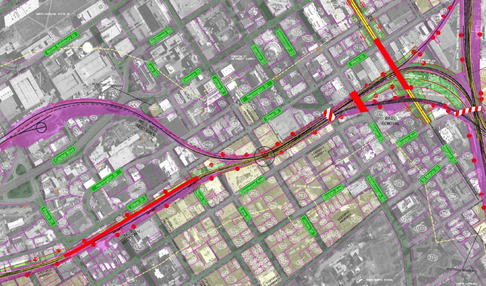
See the full map in pdf format here.
Simply put, this option would run the trains behind The Hue condo building and along the elevated tracks that go over North, Tucker, Johnson, and Peace Streets in the Glenwood South area. The train would head north along the west side of Capital Blvd and out of town.
A major drawback to this plan would be the result of having Jones street closed to traffic. Yes, completely closed and a dead end would await you when you pull up to Natty Greene’s. This is also the more expensive option.
CSX Tracks
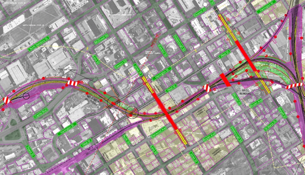
See the full map in pdf format here.
This option bends the train a little and makes it head north on the east side of Capital Blvd. To get over to the other side, the train would cross Jones Street, just like the previous proposal, cross West and Harrington Streets where it would then cruise over the already built bridge over Capital and then take off north out of the city.
This plan would result in the closing of West and Harrington Streets where the tracks cross. Jones Street would also be elevated to cross over the tracks.
My Initial Thoughts
According to Siceloff’s article, the city opposes the CSX option, which makes me happy. From his article:
The CSX route proposal would require a new bridge to elevate Jones at least 25 feet over the tracks – and over Glenwood and West streets nearby.
I had to read that one three times before it sank in. A bridge spanning almost an entire city block is not what I support for Glenwood South. Metal and concrete rising 25 feet in the air will destroy the beautiful character that the old electric company building brings to that section of Jones Street. It would also wipe out any pedestrian activity here and would be a huge blow to the massive amount of nightlife that takes place.
The Norfolk Southern route is what I will support but with a few comments about the closing of Jones Street completely. Obviously, I don’t want a bridge for cars to cross but zero access across Jones Street is not acceptable either. What the city could explore is the idea of an attractive pedestrian bridge over the railroad tracks. The dead end sections of Jones Street on either side are not needed also and a beautification study can be taken on. Two plazas on either sides of the tracks would be a really unique thing for downtown and would only encourage more pedestrian activity in the area.
Those are just my thoughts but make sure to get yours in on the SEHSR’s website or at the open house on July 26th.
Comments
Comments are disabled here. That's because we're all hanging out on the DTRaleigh Community, an online forum for passionate fans of the Oak City.
You make good points, but there’s another major flaw with closing Jones Street. It is the ONLY east-west street connecting Glenwood South & North Boylan area to the rest of downtown between Peace and Hillsborough. So if you’re in that area and you want to go anywhere else in downtown you would have to go up to Peace (which is congested enough as it is) or down to Hillsborough, which is full of slow stoplights. Connectivity suffers heavily, IMO.
I hope they can find another option somehow. Perhaps an elevated re-connection of West Lane Street to make up for the loss of Jones? That would acceptable, although pricey.
This is very true, and would be more so if Jones Street was two ways throughout downtown.
Another option I just thought of is to get the people planning this to talk to those planning the Capital Blvd. makeover. I say straighten out the grid west of Capital and make it easier to get to. That may offer a solution when the dirt starts turning in 10 or so years from now.
“Another option I just thought of is to get the people planning this to talk to those planning the Capital Blvd. makeover.”
Already happening.
Two pedestrian arches over each side of Jones street would be pretty cool.
Leo, agree, this has been moving slowly for years. Come on Raleigh planners and transit authority, get your heads out of your back ends
We NEED Light Rail as an option today. The greater number of people will ride it (Light Rail, not trains).
Do it yesterday for the growth of our area and most of all the university students throughout the Triangle!
Remember that a pedestrian bridge would also have to be 25 feet over the top of the railroad tracks.
It should not be a bridge over – it should be a path under the tracks. Probably something wider and nicer than the tunnels at NC State. A pedestrian underpass would be much easier, since it would only have to be about 12 feet below the rails instead of 25 feet above.
As for turning it into a plaza, I think that would be awesome, but a parking lot is, unfortunately, a far more likely outcome (like how Lane Street looks after 222 was built.)
I’d hate to see the Fairview to Capital Blvd bridge be closed. That’s an essential connector between downtown and all of the Five Points neighborhoods. If the Norfolk Southern router won’t be modified to keep this bridge open, then I’d heartily support the CSX option. If that means a new bridge in downtown, then that’s OK. It’ll take a while for the streetscape to adapt, but many cities have thriving districts in and around overhead rail.
My feeling is that each of these plans, as the current stand, is insufficient. They both create major connectivity problems for the Raleigh street grid. I believe we all need to push for a plan that does less damage to the driving and walking access in our city.
Artie, I agree that both plans create headaches in their own special way. After the trains pull in and people get off them, all the obstacles to get the train in will only hamper those travelers from walking around the area.
Transit outside of the car is multi-modal by nature so hurting one mode at the expense of the other is not an approach I’m happy about.