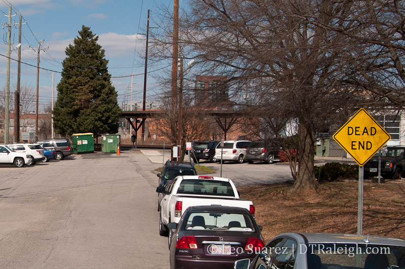
West Street
To piggyback on last week’s post about Raleigh Union Station, this week we can talk about the West Street Extension.
West Street Extension Project – City of Raleigh
The project plans to connect the part of West Street most people know in the warehouse district to the almost two block section of West Street that exists around our current Amtrak station. The street is essentially divided by the railroad tracks so to pull this off, we’ll have to take the street over or under.
This is an unfunded project that is working its way through the environmental and traffic studies. The results from this will be used towards attempts in getting funding. That work could wrap up in late 2013 with design work taking place in 2014. Construction start will all depend on that $.
Two alternatives are currently on the table so let’s go through each one.
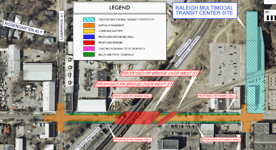
Road Under Rail Alternative
Simply put, this alternative has West Street descending into a tunnel and going under the railroad tracks. The information shows that the descent of West will go from Martin, below the tracks, and back up to meet Cabarrus Street.
Retaining walls will be used from Martin to Cabarrus so the sidewalks in front of buildings will probably feel elevated, separated from the actual street. It’s also important to note that a bridge will have to be built in order to support the tracks that now go over the street.
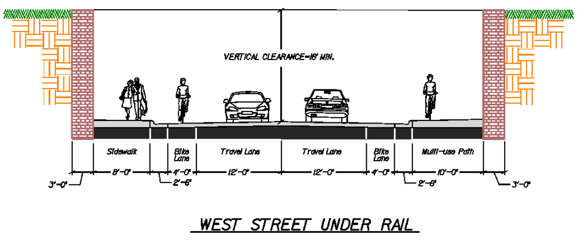
Below is a modified map of this alternative as well as a street cross section. Click for larger views.
Road Over Rail Alternative
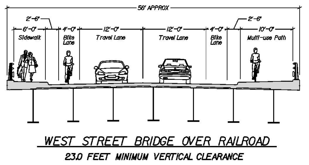
The second alternative has West Street going up and over the tracks. Like the Road Under Rail alternative, retaining walls will exist for the bridge. Since going over the tracks requires more vertical clearance (23 feet) than under (16 feet) the West Street bridge here has to start and end further back.
According to the plans, retaining walls would go from beyond the West/Martin intersection as well as past the Cabarrus/West intersection. As the plans say, “Project would eliminate access to Cabarrus St from West St” including the closure of Martin Street to West.
Maps and cross sections below.
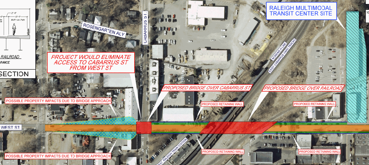
Another factor to be aware of is the fact that the Union Station platforms will close Cabarrus Street at the tracks. This will happen whether either West Street Extension alternative is chosen.
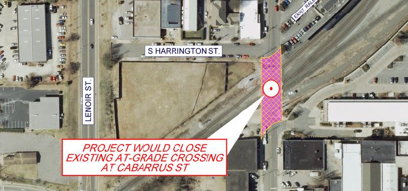
Closing of Cabarrus Street at the tracks
In my opinion, the Road Under Rail alternative seems to be the better option.
I’m a fan of maintaining as much street connectivity for as many different types of users. The closure of Martin to West and the closure of Cabarrus to West to vehicles seems too drastic. Here’s a mockup, using Google Maps, of what the area would look like if the Road Over Rail alternative was chosen.
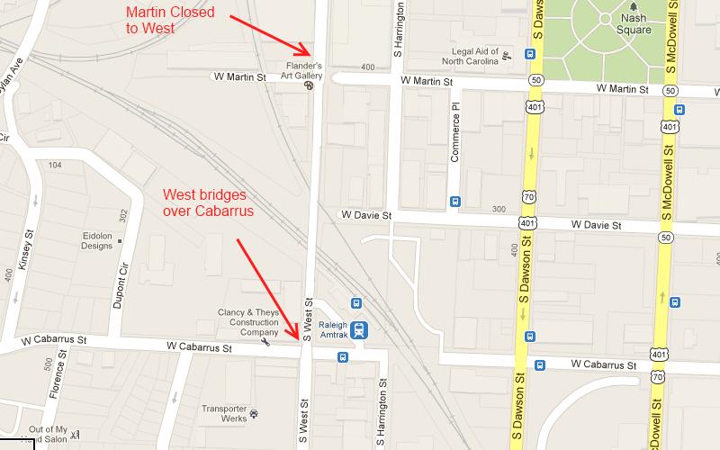
Just a mockup using Google Maps of the Road Over Rail alternative
In this section of downtown, vehicles could not travel from east to west.
The Cabarrus Street crossing will still be closed in the Road Under Rail alternative but at least we have a 4 way intersection at Martin/West and Cabarrus/West.
There is hope for pedestrians and cyclists that use Cabarrus as the city is studying alternatives for access across the tracks. I would highly recommend that readers who want the city to try and find ways to maintain bike/ped access around these obstacles to let our city staff know. (via the project page)
Comments
Comments are disabled here. That's because we're all hanging out on the DTRaleigh Community, an online forum for passionate fans of the Oak City.
Thanks for the writeup; I am in agreement that a Road Under Railroad option is the most flexible and seems like the correct option. It’s interesting to consider what the intersection at Martin St and West St should look like once Union Station is being realized as I imagine Martin St will be a key artery between Union Station and the rest of downtown.
Agreed, clearly the Road Under Rail option is the way to go. The only downside to it is cost, and an extra $10 million or so is clearly worth not eviscerating connectivity in the area. It’s a shame Cabarrus can’t be grade separated too.
West Street will eventually be extended south, I guess the plan is to connect it with Lake Wheeler Road This might happen whenever Heritage Park is rebuilt – those RHA apartments are old and really showing their age.
I don’t see the point of extending West Street past South Street. There is already South Saunders Street right there. Probably won’t happen.
Yes, the road under the rail is the obvious choice. Hopefully, it gets engineering and funding and construction in time to coincide with the opening of Union Station. (probably a long shot, but they should at least shoot for this)
It seems to me that the big point of linking West to Lake Wheeler would be to make a direct link between downtown and Dix Park.
Orulz, there is currently a direct link. Just turn twice. No need for tons more asphalt paving and tearing up neighborhoods just to drive in a straight line.
I wonder if linking West Street under the tracks would promote any development on the other side of the tracks. Are there any plans for the current Amtrack Station? I was thinking that would be an awesome spot for a new restaurant! You could even have outdoor seating on the platform under the canopy.
I actually had the same idea. In Fuquay (or technically, Varina) they converted the old rail depot into a popular bar. I think the whole stretch of West down to South St and Lenoir from West to McDowell could be vastly improved. I’ve always wondered how the little triangle of land considered the ‘warehouse district’ below the rail tracks would develop into something more than mostly unused (or underused) space.
Also, does anyone know the owner/function of the land just west of the current Amtrak station? It’s kind of a big piece of land surrounded by fence and razor wire, not really the kind of thing that seems to fit well with a residential neighborhood or a transit oriented development area.
I’m getting worried about Skyhouse. Everywhere else, Novarre seems to be moving lightning fast. Not here. This was one of the first Skyhouses announced – approved by the city back in September, I think – and they haven’t even started the permitting process yet.
I suspect there may be something going on with Sandreuter. He hasn’t started his Edison apartments either.
“This area needs to be developed with the thought process as North Hills was developed (Urban, retail, hotels, offices, food service and connectivity)”
Dear God, I hope not…
North Hills isn’t quite the worst thing in the world, but I seriously hope we can aspire towards something significantly less auto-centric and that doesn’t feel so much like “Disney Builds A City”. The mix of uses is nice, but otherwise, Raleigh deserves better.
Steve, you and I seem to have a lot of the same ideas. Send me an email mikeringram at gmail – I might have something that would interest you.
Hey Leo,
I’m just reading this article. Thank You for the info!
I agree with you. I’m in favor of the under-tracks option and maintaining connectivity. But, that’s not good for pedestrians. Based on your cross-section graphic, it looks like pedestrians will be in a long concrete channel–with a wall on the other side and traffic on the other.
I would like to see a third option that breaks the pedestrian/car corridor–one over; one under. Does a pedestrian-only overpass have to be 23 feet high? Are the grade requirements (and consequently length) just as restrictive?
What are they doing for pedestrians on Jones St. related to the High Speed Rail? Maybe something like that can be done here as well?
I’m not focused on cost… (maybe it’s prohibitive)… I just think it should be looked into.
Leo,
Thank you for this information.
The comments by Anthony are right on target and open air developments like North Hills have a track record locally and around the country (Kansas City, MO and Phoenix, AZ) are two cities I have lived in during the last decade and the revitalization of the areas around these locations is substantial and avoids the old mall feel.
BTW, are you aware of the work being done by Green Planet Catering and The Market Restaurant with their development next to Raleigh City Market? Given your interests, you might want to check it out. Local product, nearly 50 jobs, a real downtown grocery, and the only true butcher shop in the area. If you need or want contact info, let me know. We live near Peace College and the project has great potential and should be opening in the next two months.
Kevin
What is the latest with this project? Would love to hear a status update if anyone knows anything?!
[…] in this 2013 post, there were plans to tunnel West Street underneath the tracks in the depot and connect the street […]
[…] The West Street Extension Explained – The Raleigh Connoisseur, March 13, 2013 (Note the date: The City has been discussing this idea for decades, literally.) […]