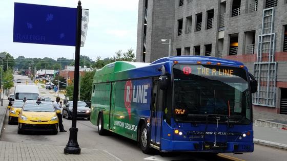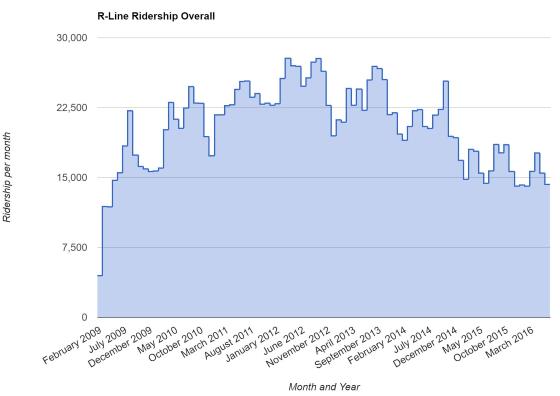
I was recently invited to talk about the R-Line on the Raleigh transit podcast, Inbound Raleigh. We gathered some ridership numbers over the lifespan of the R-Line, which is approaching its eighth birthday in February, and talked about the history of the downtown circulator.
Have a listen and let me know what you think, about the episode and the R-Line in general. You can subscribe on iTunes and most popular podcast-listening apps out there.
Here are some links to the data and images (some from those links) for your reference.
- R-Line Stats dated Sept 2016 (Google Sheets file)
- R-Line Ridership graphs by Leo Suarez (Google Sheets file)
Click for larger
Comments
Comments are disabled here. That's because we're all hanging out on the DTRaleigh Community, an online forum for passionate fans of the Oak City.


I look forward to hearing. But from first glance the declining numbers are troubling…
Without listening to the recording, I have to wonder the root causes of the RLine numbers. Could it be that it’s not going where people need it to go? Could it be the individual DT districts are getting more robust in their individual offerings and people require less movement among them? Could it be that Uber/Lyft is peeling off ridership because it’s fast and cheap? Can’t listen right now because I am multi-distracting while working but will listen later.
I have lived downtown for 2 years in Glenwood South and work on Fayetteville Street and I tried to take the Rline quite a few times, however its very challenging. The bus is not the most reliable, the wait can be way more than the 10 minutes. I find it much easier to catch CAT #6, #8 or #16, or walk to work daily. Its been more than a year since I took the Rline. Its a very slow way to get around downtown. People want quick and direct, the Rline is not that.
Get the real time tracker for your smartphone. It shows you where the buses are and will give you back the ten minutes you lose by waiting and wondering when it will arrive.
That said, I do agree that it’s not as reliable as it should be. Sometimes there’s only 1 bus running and that’s annoying. Also, I wish it would start earlier on Sunday mornings.
I listened to the recording. Here are my thoughts.
1.) Glenwood South is rapidly transforming from an entertainment district to a residential one. This might suggest changing transit patterns into the future.
2.) With both Publix and Harris Teeter coming to current RLine stops, ridership may increase and the desire to have it loop to CV may wane.
3.) While I can’t find the specific information, doesn’t the overlay tax district help fund the RLine? If this is true, then the local DT tax payers are already paying for it and other amenities that all enjoy. I’d really like to know the exact details because that will affect my viewpoint. On a side note, I don’t complain about paying for things that I don’t use in the city like the public schools. I don’t have kids and never have, yet I fully support public schools and am willing to pay for them no questions asked. But, I would ask that people think carefully about something being “given” to DT residents when they also already pay a premium in taxes (based on values) compared to other residents in similar housing across the city. The same is true for renters because the landlord just passes those taxes along to the tenant.
4.) Miami Beach’s “SouthBeach Local” costs only 25 cents and runs both clockwise and counterclockwise. I’d be more than happy to pay a token fare if we had both directions served.
5.) I do not think that the convention center is a good reason to have a service because the reality is that conventioneers are on expense reports and they’ll just take taxis and Uber/Lyft.
6.) I do use and like the Rline but think that the size of bus used is too large for its current purpose and ridership. Why can’t they be more like trolley buses that would be a better scale meandering through DT streets while being more easily branded as a DT “thing”? I’d rather have more smaller trolley buses that ran both directions than these huge buses that are not full.
I’ve always thought a loop around the downtown area was just recreating in miniature, one of the mechanisms of inner city flight…the loop. Sure it sort of got people from Glenwood to Fayetteville St, but really…who does that? I go out, probably too much (I live downtown) and almost always either pick one area or the other to hang out in for efficiency’s sake. Maybe people ‘visiting’ downtown from outlying areas approach it differently and try to take more in all in one night. Anyway, I long ago conceived of a handful of routes that either go straight N/S or E/W and essentially cross around the Capital (nice place to wait for your connector). And mine go to lots of useful places, not just drinking spots…Cameron Village, NC State, etc, so that the RLine is useful for actual residents too, not just visitors. Also, this was (when conceived a decade ago) an incentive to live downtown…easy transit around the area, and was supposed to be a sneaky way to show how light rail might work nicely and eventually rail-up [some of] the corridors I envisioned. Anyway, I don’t see why A) anyone is surprised and B)why the original vision was so half baked.
I have used the app, it only works when the bus has turned the locator on and when its only one running, the system is pointless, takes me less time to walk or catch a real bus. I say we get rid of the RLine and spend that money on getting the buses that are in downtown more frequent. If the #6 (crabtree) were every 10 or 15 minutes, you could catch the bus in glenwood south and be at moore square in 5 minutes, way quicker than waiting for the RLine to get get around downtown.
I just wish the buses ran in opposite directions and/or had larger routes. Sometimes it would be nice to hop on it for a few blocks but you’d half to sit there for a full route (eg. Warehouse District to MoJoe’s)
@Bruce. I usually choose to walk when it’s a short one and the walk from the Warehouse District to MoJoe’s is mostly downhill via West St. That one’s a no brainer in my book. But, then again, I am not walking in heels. I have to wonder how many more rides the Rline would get if dressed up couples used it more. I don’t usually see women in heels and men in suits on it.
Just from the conversation here it seems people currently use or have used the RLine for many reasons. Those reasons shift and will continue to do so as DTR and each of the districts grow and transform. Changes to the RLine will be influenced by ridership numbers and type of riders — locals, Downtown residents, students, visitors. Connecting downtown residents (apartment and condos) and visitors (hotels) to services and entertainment seems like the surest bet. For me, this means connecting Glenwood South, the Warehouse District, and Fayetteville Street/Convention Center and focusing less on Seaboard Station and N. Person Street. It also means working diligently to create focal points and gathering spaces at the center or entrances of each of these districts that then strengthen a transit connection like the RLine.
I would wonder if the money that is spent on the R-Line would be better invested if it were to be put towards the bike share program? Just an idea.
James, I think the bike share is “fully” funded by the bond that just passed. My thoughts on the wider ranging RLine are partly hinged to getting outside of the easily walkable and bike able radii.
@Mark, that’s really good news to hear that the bikeshare is funded by the bond. Now let’s hope that they put in a system of bike stations that actually works instead of one that spreads them too far apart for political reasons. The program should start with them only being downtown and possibly extending to CV and NC State along Hillsborough. Stations should be set in areas of high density housing that are near bus stops and attractions/destinations. This will encourage short ride use among a variety of active nodes. As a power user of one of these systems, I can tell you that is how it works best. It’s about point to point in less than 10 minutes for most rides.
I’ve been trying to use the R-Line more since I moved here almost 8 years ago. The biggest problem is that it doesn’t go both directions. I already drove from my house to downtown and parked. I may as well just drive a little more, rather than take a slow ride all around town. I guess if I took a Lyft, it would help, but usually it’s faster to just walk.
The Southern Gateway Corridor Study shows in the last section , ” Summary ” , that The Planning / Economic Dept. has listed a Public / Private Partnership Project on Tryon Rd. ! Wonder if this could be a sports stadium ! It shows a short/mid term time frame , not a long term time frame. Just a thought ! Also The Railhawks is saying on their web site that they will make a major announcement next week !
Dwight. It’s not a stadium. The report clearly calls for commercial/residential mixed-use center.
According to most sources, RailHawks announcement is likely a rebranding and maybe also launching a women’s pro team.
OK , Thanks Mike! I didn’t put the two together.
John 532, I honestly don’t remember where I heard that….I *think* it was from a good friend who is a City employee (hey City employee friend, if you see this please weigh in). The bond is supplementing other funding sources and leaves a lot of discretion to the County’s municipalities. Having said that, I put my “fully” in quotes in the earlier post, because what a fully funded bike share looks like is in the eye of the beholder. I’ve used them in a few cities (not a power user at all though) and the location of that next stall is the all important factor in deciding whether or not to take one to me.
@Mark. Yep. You understand how bike share works. If there aren’t station options where most people want to go, it will flop. This is why the city has to resist every Tom, Dick and Harry getting ONE station in their general neighborhood because, you know, they are entitled to one. That will kill the system because, guess what?…, nobody wants to go to their neighborhoods. The stations initially need to be tightly clustered DT in key locations where many people live and where many people want to go. This will enable subscribers to leverage it effectively and allow the bikes to be easily shuffled around when necessary by those managing the system. It can grow and expand over time.
The system I use is CitiBike in Miami. It started relatively small in SouthBeach and expanded as it became more successful. After a few years, it jumped the Bay into Miami proper and now it’s a very robust system of bikes that are used by locals and tourists alike. FWIW, I split time between Miami Beach and DT Raleigh and I use the bikeshare more than a car when in South Beach. Look at this map for how tightly the stations are clustered in South Beach http://citibikemiami.com/station-map