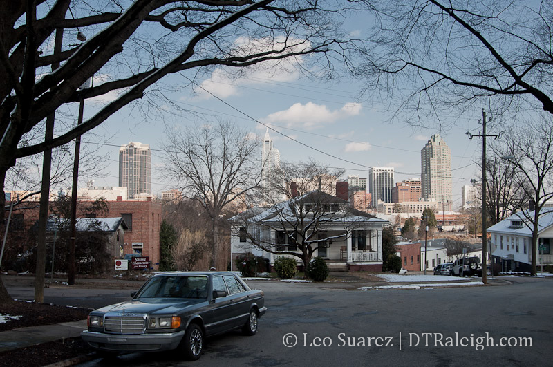
I had a few exchanges on Twitter recently and the question being discussed was simple. Do you consider Glenwood South to be a part of Downtown Raleigh? This followed with more conversation of what is and isn’t consider to be in downtown.
In cases of real estate or jurisdiction, hard lines specifying what’s in or out are needed. For awhile, I’ve felt that this doesn’t work with locals and visitors. I may have a new way of thinking about this that I want to put on this blog.
I chimed in to the Twitter conversation and gave my personal definition of what areas make downtown. Here’s the short, dictionary-type definition.
Downtown Raleigh is a patchwork of unique, urban districts and the neighborhoods that border them where easy accessibility is possible by all users.
I realize the “downtown or not?” question will always exist but I want to try a different approach to this rather than the traditional “lines on a map” method.
For background, let’s start with the city’s definition. According to iMaps, I’ve redrawn the Downtown Overlay District on this Google Map.
View Downtown Overlay District in a larger map
The railroads must have some influence on this map in some way as most of the west and southern borders are train tracks.
Most of Glenwood South is not considered in downtown but rather a different section called the Pedestrian Overlay District. Not quite the same ring as Downtown but ok.
Next, we have the Downtown Raleigh Alliance and they have broken up the area into districts. The idea of districts have become part of their branding, it’s even in their logo, and terms like Warehouse District and Government District are catching on.
Their site consists of a nice map and with the districts clearly specified. If you are in one of the five districts, you are in downtown.
So finally, I want to remove the maps, remove the boundaries, and try to humanize this a little more.
Downtown Raleigh consists of any areas, blocks, neighborhoods, and buildings that are within the core and around it. I’m loosening the definition a bit because the situation changes for everyone. If you can get out and feel comfortable walking from within the neighborhoods to Fayetteville Street, for example, then you are in downtown. However, if you are at a point where that walk is just a little too much then you are probably located on the fringes or just outside.
This could make a great data visualization project. If the data could be gathered, it would be possible to “draw” what downtown is by the method of how people travel to and within it. Walkers, cyclists, transit riders, and drivers are coming from all over. As you travel away, each method starts to decrease. There are less walkers the further you go. Beyond that, cyclists drop off. Last transit riders aren’t there and only drivers are within reach.
This blog considers downtown Raleigh to be the theoretical area drawn up by all of these travelers together.
I wanted to put this out there as some of you may be interested in a new way of defining Raleigh’s downtown. I also wanted to get this up because I have a feeling I will be referring back to it in future conversations.
Oh, the answer to the original question is yes, Glenwood South is in downtown Raleigh.
Comments
Comments are disabled here. That's because we're all hanging out on the DTRaleigh Community, an online forum for passionate fans of the Oak City.
If anything!!! Downtown Raleigh needs to be expanded. I am not impressed at all with what the Christmas guy did decades ago (what lack of vision – a grid, that type of thinking is NOT creative or ahead of it’s time).
Downtown Raleigh’s layout/borders are much to small/confined.
Streets and sidewalks narrow (this is a result of the Christmas dud not knowing what he was doing, how could you not factor in growth and make streets four lanes and sidewalks wide enough for foot traffic, no one can argue this point, it’s just common sense, which obviously Christmas did not have, we should not be applauding this guy)
EXPAND downtown further East and further South (this is a great location for a New PNC Arena)
Yeaaaa. When I think of downtown, the first thing I want is four lanes of cars.
Also, the point of the article seems to be that the bounds of downtown are what YOU make them. They are arbitrary. If you can walk or bike from the East or South – then go right ahead and consider that downtown. Nobody’s stopping you.
I say Glenwood South is part of DTR. My walk to Natty Greene’s is about the same distance as it is to Times.
You could say the “core” of DTR is Fayetteville St and work your way out from there.
Paul, are you joking? I hope so. The William Christmas plan was drawn up in 1792. When we talk about the Christmas plan, it’s not saying “Wow, what foresight!” it’s more acknowledging and appreciating that it’s our city’s history.
And in fact, for a little backwater like Raleigh, 66 foot wide streets were pretty big, for 1792.
Leo, I like your idea of defining downtown basically by the number of people walking. The problem with that definition is that to determine the boundaries would take lots of pedestrian count surveys.
My personal definition of downtown is the pentagon of Peace, Person, MLK, St Mary’s, and the NCRR. There may be a couple places where the boundary would extend a block or so further out, but generally that’s it. I don’t see how you can exclude Glenwood South from downtown.
I just moved to Pilot Mill several blocks north of Peace College and consider us to be living “Downtown” but in the Mordecai and Pilot Mill neighborhoods. I walk from my house to Fayetteville St. quite a bit and will be a pedestrian commuter once my office moves to Davie St. (soon! woohoo!). For now, I think a basic walking radius to Fayetteville St. is a decent measure, but that will surely change over time. It could even shrink if certain areas thrive in the future, for example the Person St. District. If it solidifies into a destination area it could then become the reference people in the area use when describing where they live/work/play.
I think that orulz said it perfectly and I totally agree with him. As for Glenwood South being part of downtown, I would say “yes”. When our city leaders made the decision to include it in the downtown proper they demonstrated great vision. Boundaries are not always the result of “what looks right” but rather of “what makes more sense”. Making Glenwood South a transitional area of downtown helped the latter blend better with the rest of the central neighborhoods and helped downtown’s image.
In the future, I anticipate more areas to become part of downtown. Areas like South of MLK Blvd, as far as the Beltline. Right now, it may appear more like a “predatory” move, but as downtown grows, it will make more sense. Maybe 10-15 years down the road development will expand towards South of downtown in a more aggressive manner.
On second thought, I guess it depends on what you’re trying to accomplish with the “Downtown” moniker. I’m thinking of NYC where just about all of Manhattan could call itself generically downtown, but there is, of course, an actual smaller area that is really called “Downtown.” With that in mind, an area like Glenwood South could generically be called downtown, but would be a separate area to the true “Downtown” district. Similar to, say, Tribeca. It’s right there next to Downtown and is certainly walkable, but it is its own district with its own identity…
Good point, raleighing. I’ve thought of that scenario and that depends on who you are talking to. If I meet you downtown and ask, “Where do you live?” you could say Pilot Mill and that makes sense.
But if you meet someone at the airport and they ask you the same question, most likely answering “Downtown Raleigh” is better.
If you were in Washinton DC, the answer would just be Raleigh. If in China, “North Carolina” or “USA.” You see where I’m going with this?
In that situation, it depends on the “view” (need a better word) that you are answering that question from.
I say yes. Heck, the downtown overlay map doesn’t consider Oakwood or Boylan Heights as being in the “downtown” area, and I consider them two of the best examples of downtown living.
Leo, that’s a good point. To a lot of the people I work with who commute from Johnson & Franklin counties, they consider me living in Five Points as living downtown. But I don’t have the same reference point. To me, my friends in Oakwood are at the edge of downtown.
This is a great topic Leo. Thank you for initiating it. There may be a more holistic way of defining downtown: Central Business District (CBD) + its adjacent residential neighborhoods = Downtown. The CBD consists of the five districts (created by city; promoted by DRA) and the adjacent neighborhoods include those that touch the physical boundaries of the CBD such as: Glenwood Brooklyn, Boylan Heights, Oakwood, Mordecai (Pilot Mill where I live seems to be part of Mordecai), and South Park are downtown neighborhoods. This helps to avoid the false argument that a certain neighborhood is not a part of downtown. Of course it is. And we should embrace that idea.
The downtown overlay district shown is essentially an amendment to the code that allows for, among other things, variations on parking, exemptions on open space & height limitations and setback reductions.
In Raleigh’s own 2030 plan, the CBD includes most of what is considered Glenwood South as well as areas up Capital Boulevard to Wade Ave. This plan seems to validate what some others are saying here that the concept of DT should be expanded as the city grows into the future. I agree with this notion but think that it can be even more agressive than the 2030 plan.
For me, the current boundaries of DT would include all of Glenwood South bounded by the intersection of St. Mary’s and Peace Streets. It would also include the northern designation of the CBD in the 2030 plan. This includes Seaboard up toward Mordecai. Where the natural boundary lies for me is where mix use/high density/commercial turns solely into single family housing. In the same way that I would not consider Cameron Park to be DT, I also wouldn’t push the boundaries of DT far north into Mordecai proper or east of Person into Oakwood. However, I would include the blocks between Person and Blount north of Peace to Delway St. (or where Person become Wake Forest Rd.) For me, this extends DT to border its adjacent urban neighborhoods. Similarly and also consistent with the 2030 plan, I’d like to see DT push westward along Hillsborough to the round-a-bout with Morgan St. and Southward to the railroad tracks.
While I agree with that notion of pushing DT proper southward beyond MLK, it would take a concerted effort to change its current infrastructure. Both going out of town on Dawson Street and coming into town on Mc Dowell and Hammond set the tone for a decidedly un-urban environment. However, I can imagine DT’s push eastward out the New Bern Corridor and to the east of Shaw University. While those areas are primarily single family, the diversity of structure type is enough for me to imagine more of a Glenwood South environment with “former” single family houses repuposed and co-mingled with mix used buildings and high density housing.
The comments on what your view is, is pretty poignant.
I’ve met people from Wakefield & Brier Creek areas talk as if anyone who lives anywhere Inside the Beltline lives “Downtown”. Even regarding a mutual friend who lived just above Lake Johnson, I kid you not! :-P
And yet, I know a couple who live near WakeMed just inside the beltline, and I heard them once say “We live way out east near Knightdale”. I was like, Whoah, not quite! LOL