Three Plans On The Table For New Park at Devereux Meadow

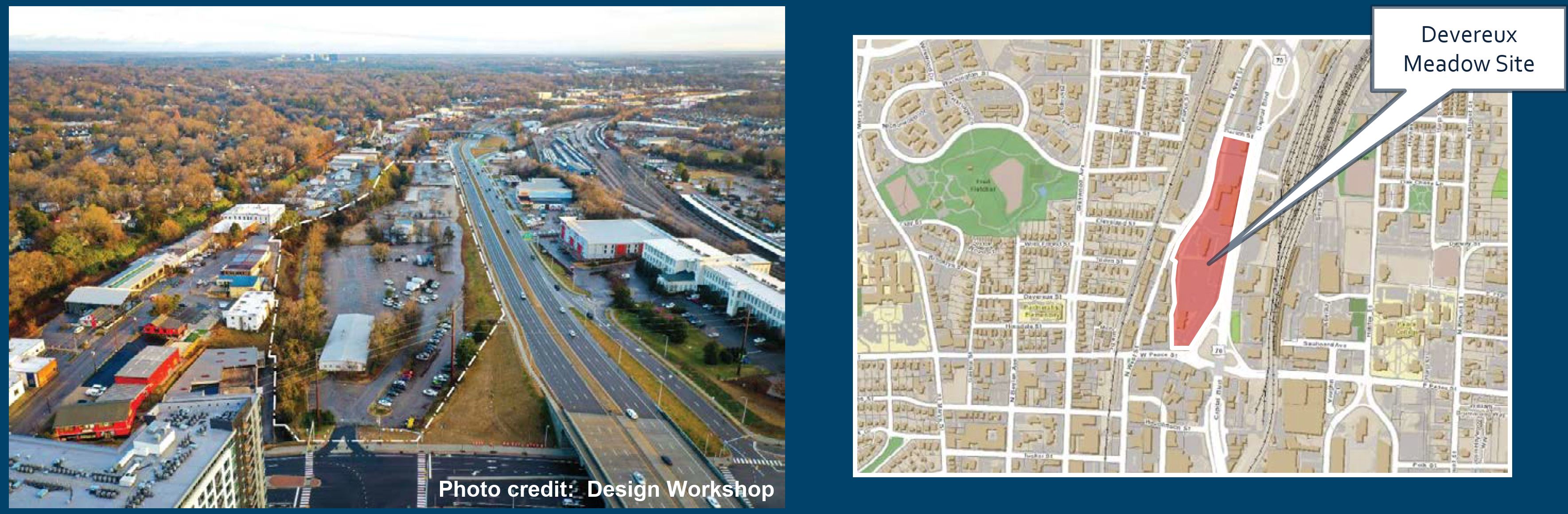
The city held a virtual open house in May, 2021 about a future urban park at the Devereux Meadow site. The site sits just north of Peace Street directly west of Capital Boulevard. It’s currently being used to store city vehicles but that will all be moved soon. Jump into the video above for the full 2-hour details, or 1 hour and 20 min if you watch it at 1.5x speed, the preferred watching speed here at DTRaleigh HQ.

You can also check out the project page on the city’s website for the slides and contact information: Devereux Meadow Project

There’s even a survey for you to fill out.

Devereux Meadow has popped in and out of the blog over the years as the site has been mentioned for future plans going back all the way to a 2011 Capital Boulevard Corridor study. That street is well documented on this site and I even have a post up about the baseball field that was built in 1938 right next to Capital. Finally, the Devereux Meadow site has been planned to become a park as part of the 2015 Downtown Plan which I covered here.

The session and presentation is quite nice and in addition contains some history. Even more history can be watched in an additional video.

Getting back to the present, the plans for the urban park are starting to materialize as the city is in the process of finalizing the schematic design. The construction of the park itself is still unfunded but could be on a future, this year even, parks bond.

The team is presenting three concepts for your review and I’d like to share each one below. The main points of each plan address the Pigeon House Branch creek in different ways and I think everything else kind of reacts around it.

Line Drive

The Line Drive concept is the first one in the list and does the least, relatively, to the creek compared to the other two plans. The creek “is stabilized in place, with stream shelf and instream structures to promote floodplain connectivity and bedform diversity.” A portion of the creek that is currently covered in concrete would remain.

This plans comes in as the cheapest and the report sums up how it stacks up against the rest with:

“Stabilization in place of the current stream. Aqueduct, site access road and Dortch Street culverts remain, leaving no room for stream alignment or grade manipulation. Incorporation of a stream shelf promotes floodplain connectivity, and instream structures develop bedform diversity. Lowest cost, lowest ecological uplift.”

Sculpt

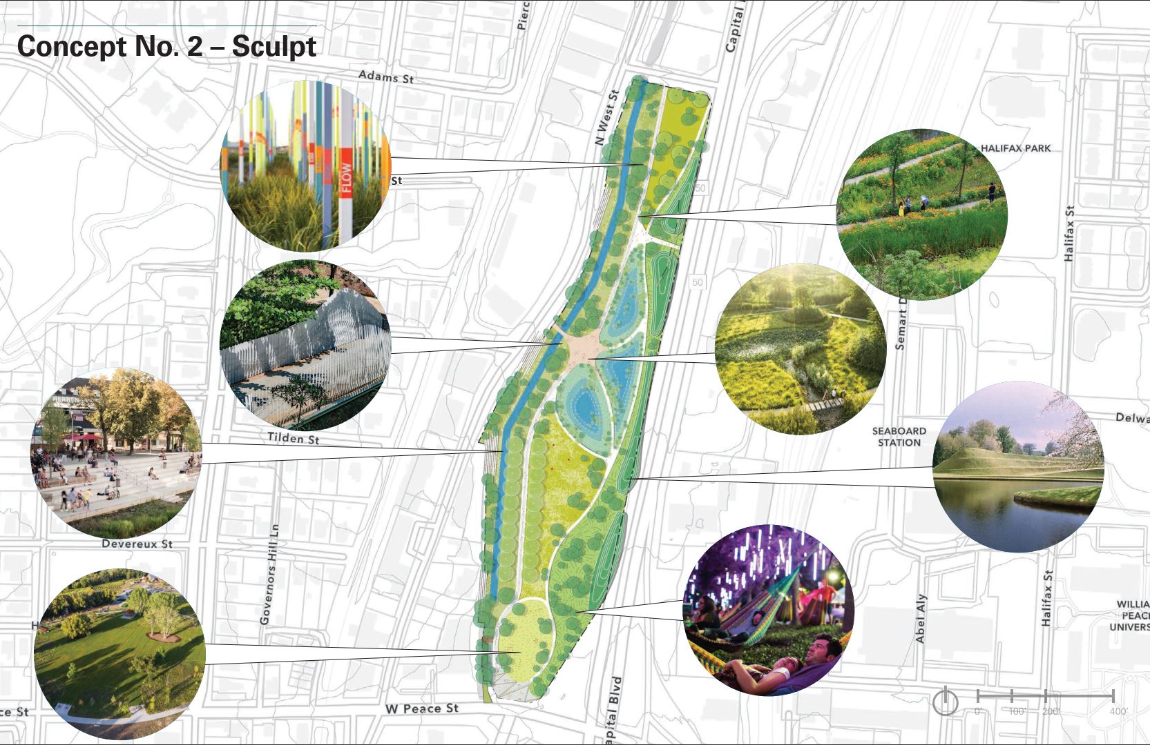
The Sculpt concept is the “middle” option, for lack of a better word, as this one has some work being done to the stream and the cost is in-between the other two. This plan opens up the creek a bit as that concrete cap on the southern end is removed. The creek “is restored in place, with increased stream bench and instream structures for greater habitat and flood capacity and bedform diversity.”

The high-level states:

“Removal of the concrete cap over the aqueduct and limited manipulation of the stream alignment and profile. Increased extent of stream bench for greater habitat and flood capacity. Instream structures develop bedform diversity. Moderate cost, moderate ecological uplift.”

Meander

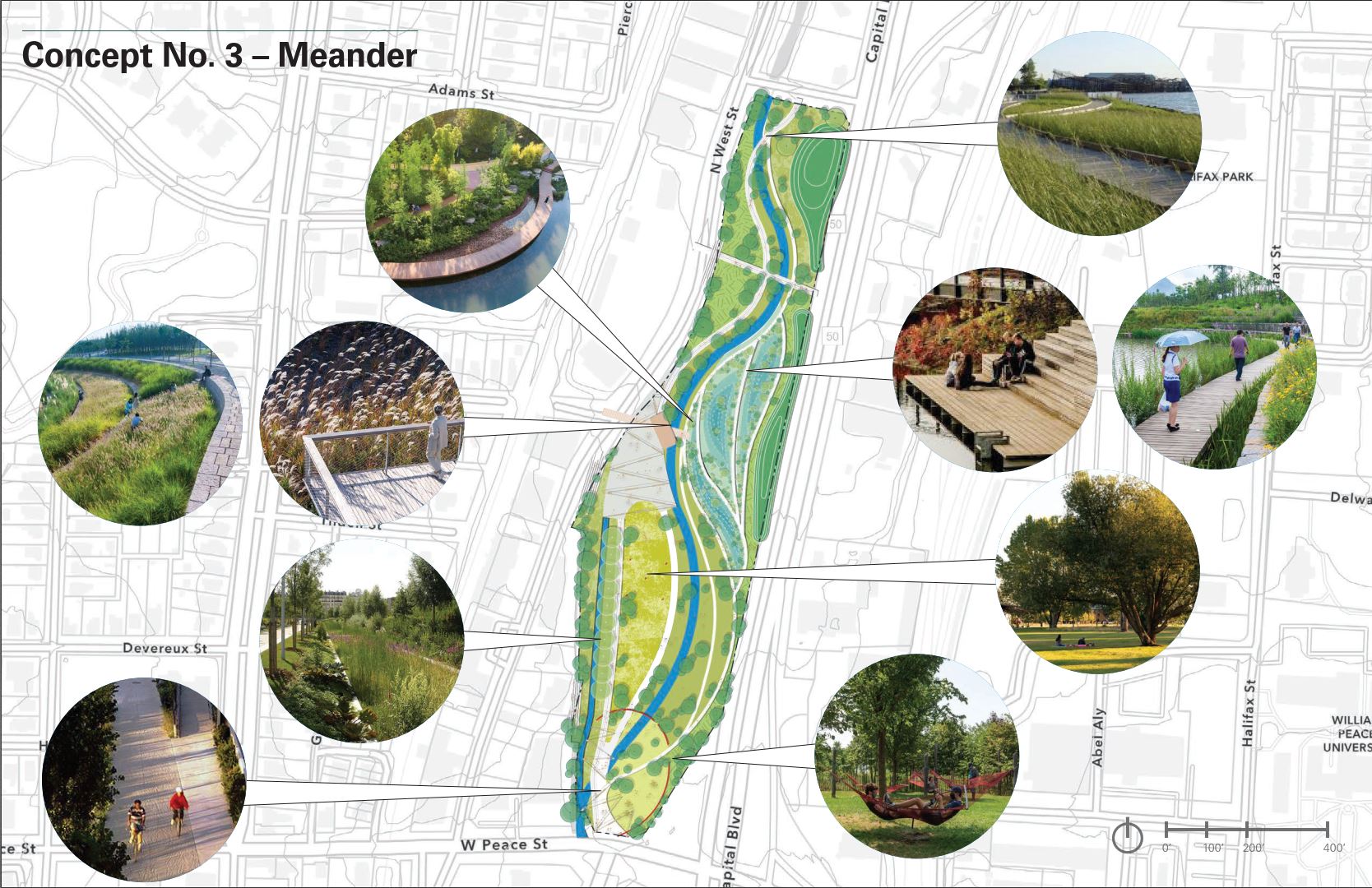
Meander would offer the most significant transformation. As you can see, the stream is practically reconfigured on the site and would offer flowing walking paths alongside. In this plan, “Pigeon House Branch is realigned, with stream and floodplain designed to maximize floodplain connection, habitat health and visitor interaction.”

There’s also the most opportunities for programming and public uses of the space. As the report states:

“Total relocation of the stream alignment and profile. Stream and floodplain design are based on bankfull hydrology and maximize floodplain connection and function. Greatest potential for visitor interaction, diverse habitat communities, and incorporation of stormwater treatment. Highest cost, highest ecological uplift.”

Which one do you like? Make sure and take the survey and give the city your thoughts.

For me, I go back and forth between Sculpt and Meander but I think Sculpt gets my vote. There’s a line of oak trees, referred to as the Oak Allée, on the western side where new oaks would be planted as part of Sculpt. The other two plans don’t have that. In addition to opening up the stream on both plans, this just seems like a nice element to have in the future, once the new oaks mature.

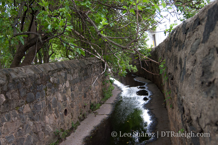
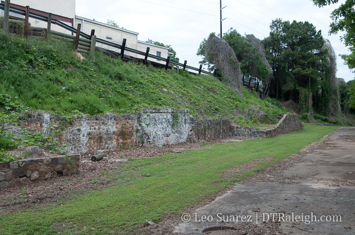
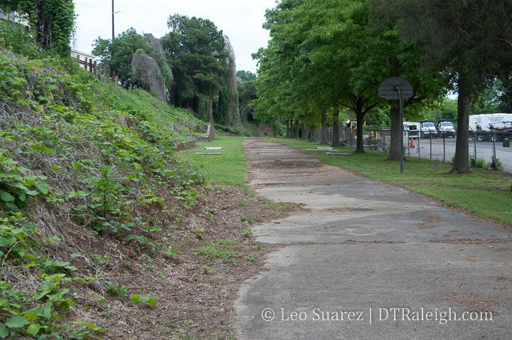
Finally, I have to share some old photos I took when I lurked around the area in 2012. You can see the concrete cap over the creek and some of the oak trees. These are around the southwestern side of the site.

What positives or negatives do you see? Come over to the Community and discuss it with us.

A Walk Down New Bern Avenue

The blog and Community tend to focus on new developments in the downtown core, such as 301 Hillsborough or The Willard hotel, that we may be overlooking some other activity just on the outskirts of downtown Raleigh. I thought it time for another Walk Series post to show off the east side of downtown, mainly the New Bern corridor.

The New Bern corridor interests me mainly due to some key observations and upcoming projects:

  • Planned location of the city’s first Bus-Rapid Transit route
  • Increased residential units from new townhome developments
  • Upcoming zoning conversations for the area

Loosely defined, for this Walk post, I’m focused on New Bern and Edenton Streets between Tarboro and East.

BRT Transit is Coming

With the implementation of the 1/2 cent sales tax for transit in 2017, higher-capacity transit, among other improvements, are being planned all over the county. Along New Bern and Edenton Streets, bus-rapid transit (BRT) will be rolling through in a few years if everything stays on schedule.

Being one of four planned BRT routes, high frequency transit will be flowing in and out of downtown Raleigh to the eastern parts of the county. Read more about the plan for BRT here.

The corridor may see dedicated bus lanes, expanded bike lanes, and new sidewalks on both sides of the street. It’s a big upgrade for the same corridor that currently runs the GoRaleigh bus route with the second highest ridership in that transit system.

Tarboro and New Bern/Edenton is loosely planned to get a BRT station on this upgraded route. The next stop inbound would be downtown itself.

Last reported, before the pandemic hit, plans were to be rolling buses in 2023-2024.

From Single-Family to Townhome

Historically, the corridor consists of many larger lots with single-family homes. You can still get a sense of the character going back to the early 1900s with the bungalows and larger houses facing the street.

However, it’s not hard to spot some newer homes, mostly of modern architecture style, sprinkled throughout the area. These homes were popping up between about 2008 until today. These homes add a stark contrast to the area as you can see in the photos.

And if you really look more, the modern townhome seems to be making its way into the corridor as of recently. First, the ten-unit project named 10 Arros completed along New Bern within the last few years. Construction is currently taking place at 625 New Bern where 18 units are planned. Similar modern style as the former.

Finally, across the street from 625 New Bern is Oak City Overlook. This development plans 20 modern townhomes and land has already been cleared at the site.

Could more be coming? I’ve seen plans submitted for more and you have for sale signs like this one at 914 New Bern which advertise, “Townhome/Condo Site for Sale.”

And there’s no shortage of space along this corridor. As I mentioned earlier, the single-family houses are on large lots that could easily be subdivided.

You also have the North Carolina State government vacating a large site at New Bern and Tarboro. The long-time site of the NC DMV is being vacated soon and that’ll put 5.4 acres of land a stone’s throw away from a rapid transit stop. Any development here, plus the adjacent surface parking that supported the NC DMV, could greatly change over if the state decides to sell it.

We also have 8 acres of undeveloped land at New Bern and Swain. Currently, the lot is only partially used by the Exploris school in temporary buildings but 8 acres offers a ton of flexibility, capable of a pretty transformative project. Just look at the map above, it’s that empty lot in the middle. That’s huge!

Zoning it Properly

From my perspective, you have two forces that are about to collide. The development is coming. Should transit only serve the single-family and new, high-end townhomes being built here?

To get more people access to the future transit network, an awkward conversation is soon to come, Raleigh. It’s time to talk about re-zoning the area.

This is a good time to revisit a collaborative post I did about a zoning tool called the Neighborhood Conservation Overlay District (NCOD) and it just so happens that this area has one right in the middle. Below is the New Bern – Edenton NCOD and you can see, almost everything mentioned so far sits right inside it.

In short, the NCOD applies additional restrictions on height, setbacks, and is a tool to encourage new development be consistent with the current character. This NCOD was put in place in 1992.

To make transit more effective, these townhome developments help but we’ll need some larger projects in here to ensure additional office and residential density as they will be within walking distance of a high-frequency bus stop. It is a prime opportunity to get Raleigh residents on a car-less lifestyle at a variety of income levels.

I feel that the NCOD implemented in 1992 needs a revisit and with the current talks of more affordable housing around transit, it would be better to deliver hundreds (thousands?) of new units here rather than status quo townhomes near transit.

The land is still available but the development is starting to pick up. I’m hoping the city can start purchasing land for affordable housing as well as pushing for new zoning updates to match our 2030 and beyond goals as a city.

More conversations on this topic are sure to come.

The Unintended Consequences to Conserving Raleigh’s Neighborhoods

[This post was written in collaboration with James Demby. James is fascinated by how and why different housing types are or are not built. He has been doing an informal study into what has happened in Raleigh housing (ITB specifically) over the last 10 years. See more of that on Twitter.]

Buckhead Drive, Raleigh.

Tom Whaley has noticed a lot of changes going on in his neighborhood in the past year. He lives in the North Ridge West neighborhood of Raleigh and worked with some of his neighbors through the city’s Neighborhood Conservation Overlay District process, or NCOD for short.

“Houses being bought, torn down, lots being split up, houses being rebuilt that were much larger and much denser,” Whaley said. “Those types of homes were not fitting into the characteristics of our current area.”

North Ridge West predominantly consists of one- and two-story houses built in the late 1960s through the 1970s. The typical size of a property there is around 20,000 square feet or almost half an acre. If you are doing the math, that comes out to about two houses per acre.

The city’s development code allows for six houses per acre in this area which, in response to Raleigh’s growth in the housing market, allows for the lots to be subdivided for more housing. The neighbors there see this activity as a problem.

“We’re seeking an NCOD due to a point of inconsistency with the zoning and the current build-out,” says Peggy McIntyre, one of the original petitioners and resident in North Ridge West who helped get this process started.

There is nothing wrong with Raleigh citizens getting together and choosing to rezone themselves, but as more and more NCODs are being put into place, it is a good time to ask, “What are the possible impacts of allowing whole neighborhoods to do this?” Since the first one in 1990, NCODs are starting to become a frequent occurrence and their restrictive zoning conditions may have unintended consequences for the city’s big-picture goals.

Source: Open Data Raleigh – link. See larger map here.

Above is a map of all NCODs in place in Raleigh. Feel free to browse the map and click on each shape to see a pop-up of information on each one, including the name and date it was put into place.

NCOD Highlights

  • Number of NCODs: 20
  • Year of first NCOD: 1990
  • Smallest NCOD: 24 Acres (North Ridge West)
  • Largest NCOD: 557 Acres (Brookhaven)

What is an NCOD?

An NCOD is a zoning tool intended to create a specific result. The City of Raleigh officially defines a Neighborhood Conservation Overlay District (NCOD) as:

A zoning overlay that preserves and enhances the general quality and appearance of neighborhoods by regulating built environment characteristics such as lot size, lot width, setbacks, building height, and vehicular surface area. NCODs generally apply more restrictive standards than base zoning districts.

Character Preservation Overlay Districts – City of Raleigh – link

The city has a number of zoning types that are standard throughout the city. If you are in an R-10, for example, near Crabtree Valley mall or in R-10 zoning near South Park, you have the exact same restrictions as far as the city is concerned. NCODs create specialty overlays to add more restrictions to an area. The NCOD would create additions to the base zoning, so instead of R-10, you would have “R-10 with NCOD conditions.” Each NCOD gets their own additional, custom restrictions and they are listed in our city’s development ordinance, one-by-one.

NCODs are not Historic Overlays Districts. Historic Overlays consider the historical significance of a group of buildings from Raleigh’s past to protect them. NCODs do not necessarily take into account historical aspects of the buildings or structures of an area.

Why would someone want an NCOD?

The most often mentioned reason for wanting an NCOD has been as a response to teardowns. In these cases, a teardown might mean that a smaller, older home is replaced with a new home, larger than the ones nearby.

Lot splits are also a common reason for applying for an NCOD. This happens when an existing lot is divided and the former home removed for two new ones.

Residents near these changes can see an NCOD as a way to stop these types of changes. A desire to keep a neighborhood the way it was, sometimes described as its “character,” is a frequent motivation for requesting an NCOD. Every instance of NCOD so far in Raleigh has been to add a restriction to what can be built in that area. 

Affordability has also been used as a reason to put an NCOD into place. With Raleigh’s growth, older homes have been torn down and being replaced with newer ones, resulting in the higher prices that come with new construction. If teardowns can be prevented, the thinking is that the area stays affordable.

As you can imagine, a lot of aspects come up when thinking about the character of a place. Distance between houses, trees, density, and traffic are just some factors in most residents’ idea of neighborhood character.

These can be good, even great things, to protect. Yet the NCOD zoning could be creating conflict in the Raleigh of today.

Controversy and Potential Conflict?

Recently, the most cited reason for adding an NCOD has been to stop lots from being split and old homes from being torn down and replaced by bigger, more expensive ones. That doesn’t sound like the worst idea on the surface, but where this has been controversial is in the execution. 

Because of the steps required to obtain an NCOD, these overlays are generally going to wealthier and more organized neighborhoods. So, we are making special protection districts for the areas that already have the most resources, adding privilege. 

The other controversy is that NCODs have all been pointed toward restricting housing types. While blocking lot splits, they also block any type of added density. This means that growth will always be pushed somewhere else. If we add restrictions on certain areas, then that means other areas must absorb growth. This rewards the organized communities while adding pressure to other areas.

NCODs never expire, making them a tricky restriction when planning for the future. The situation around an NCOD may change dramatically, but it now takes 50% of the people in that NCOD to make any new change to even a few properties.

The King Charles NCOD is a good example of this. It was planned with restrictions including a 0.7 acre lot minimum at a time when the neighborhood expected most of Raleigh’s growth to go in another direction. Then years later, the nearby New Bern Corridor was selected for Bus Rapid Transit (BRT) and now roughly a third of the area around this big investment in transit will be locked down with an NCOD requiring 0.7 acres per lot. This is now in conflict with the need for density near transit.

The King Charles NCOD, shown in the brown “house” overlay, has a minimum lot size of 0.77 acres, 2-story height limit and minimum 144 feet lot width. Today, planning for a bus-rapid transit line on New Bern Avenue is ongoing. Click for larger.

An interesting side of the controversy around NCODs is whether they protect affordability. In the immediate short term they may, so when neighbors see teardowns and McMansions the NCOD is seen as a way to keep the older more affordable homes intact. 

On the other hand, NCODs are not being used to encourage additional smaller units that could be more affordable; they are usually just restricting the number of homes in the area to stay exactly the same. In a growing city and desirable neighborhood, this could mean that even though the older homes are less expensive than new ones, they now see their value grow even more because they are the only option for the area. In the last few NCODs that have been brought up by council, the older homes in the area have already been worth over $350,000 or higher.

Wrapping Up

Thankfully, there has been some talk at the council level and in planning commission that the NCOD zoning tool may not be generating the results it was designed to create. This conversation needs to be pushed further and with a higher priority as NCOD applications are rolling in, with one every year since 2016. Two have been adopted this year (2019), and a third is on pace for approval in 2020.

With NCOD’s, we are allowing Raleighites to self-restrict in a way that may be giving them an advantage over other areas of the city. This process is not equitable, because the most organized and most diligent get the rewards.

The process also pits neighbors against each other due to the fact that only 51% of an area needs to agree to an NCOD. This process therefore rewards homogeneous areas versus those that are diverse. It also sets in place restrictions for future generations that may want different things.

There may come a tipping point where we’ve custom-zoned too much of the city. Currently, 3.35% of the city is inside an NCOD. Raleigh is planning for growth along transit corridors, corridors that currently have NCOD restrictions in place. This only makes it more difficult to plan for proper housing close to transit.

Fighting for neighborhood protections doesn’t necessarily need to stop altogether in Raleigh. It’s just time to start thinking about the potential impacts these “frozen in time” restrictions have toward Raleigh’s future.

Browsing Through The Latest Civic Campus Master Plan

The city has posted the latest version of the master plan for the downtown civic campus. This would involve a significant update to the municipal buildings to the north of Nash Square. Over time, it’s possible that the existing buildings will all be demolished and up to 20-story towers for city workers will be built on this block.

Jump into the plan (pdf doc) here on the city’s website.

The Avery C. Upchurch block, or municipal block as I’m calling it, consists of the former Raleigh Police Headquarters building, the Raleigh municipal building (RMB) currently in use, and a 3-story parking deck. The police HQ is currently vacant and we’ve outgrown the RMB to the point where extensive maintenance is needed in the next few years.

From the executive summary in the master plan:

The future Raleigh Civic Campus will be a mixed-use, walkable destination consisting of a New City Hall with public-facing government functions, expanded municipal departmental space, and pedestrian-connected public spaces. Other land uses may be arranged around the campus, including urban retail, commercial office, housing, and a combination of below-grade and structured parking. The total potential of the Civic Campus is approximately 2.2 million gross square feet, excluding underground parking and services. The full build-out of the campus is dependent upon the execution of several capital projects over three phases and employing a suite of delivery methods, including City-owned and managed development, private capital-led development, and potentially a collaborative public-private partnership.

The full implementation of the campus will take place over 3 phases, generally broken down into these projects:

  • Phase 1 – The East Building: Demolish the Police HQ and build a 20-story office tower for approximately 1,400 staff, public-facing functions, and Council Chambers, as well as potential ground floor retail.
  • Phase 2 – The West Building: Demolish the RMB and tentatively plan for an up to 20-story office tower, the twin to the East Building. A public plaza between the two towers will tie the two sites together.
  • Phase 3 – Mixed-Use Development: Demolish the municipal parking deck and allow for up to 20-story private development.

The additional space on this campus will be for current workers who are spread across downtown as well as new hires in the future. The civic campus aims to consolidate offices and bring together departments as a way to make the campus more secure and more customer-friendly in a cost-conscious manner.

The master plan lays out the costs of doing nothing and just maintaining buildings and the difference is in the tens of millions of dollars. See page 18 for more details.

As each department continues to grow, accommodation of the City’s expanding workforce in an organized and fiscally responsible manner will become increasingly difficult. City staff has conservatively estimated the need to invest more than $245 Million (in today’s dollars) over the next 30 years just to maintain the status quo.

The master plan really focuses on delivering the needs of the city for the next 30-40 years between these two towers, the East Building, and West Building. (Phases 1 and 2) Mixed-use development through collaboration with a private developer for phase 3 isn’t quite set in stone, which makes sense. It’s a good opportunity to provide something that’s needed on the northern end of the block such as housing or hospitality but those needs haven’t been identified just yet.

There’s plenty of opportunities to build as the entire block is zoned DX-20-SH, or downtown mixed-use with a 20-story height limit, shopfront design. This is significantly mroe dense than what we have today.

With a much larger presence here on the municipal block, the civic campus becomes a destination and should help connect downtown districts. This is touched on more in the master plan where the design team has thought about connecting it along the east-west streets of Morgan and Hargett from the Warehouse District to Fayetteville Street. Nash Square should not feel isolated from the campus but rather become an extension.

This makes pedestrians number one along Hargett Street and the public plaza must emphasize that. Taking cues from the 2015 Downtown Plan, this vision supports Hargett Street having an attractive and livelier streetscape.

The master plan continues with details about a central gathering space and plaza within the site and possible uses for the mixed-use portion on the northern half. The examples from other cities are helpful in visualizing what is possible so I encourage readers to check it out.

I’m very happy with what’s in this master plan and feel it’s got all the right elements put together for this area. In my opinion, some points really need to be hammered home once the city gets into the details. I would want to really emphasize the need to make the municipal buildings along Hargett welcoming and engaged with the sidewalk rather than being stale, public buildings.

The SECU tower is a good example of how a modern tower can engage the sidewalk, provide outdoor spaces for gathering and mix it with retail. (if they had any so I have to pretend) The county’s justice center seems to have missed the mark with their monolithic presence along Martin Street and their foreboding main entrance along Salisbury. (I love the art deco look from afar though)

I’d love to see Hargett Street get the “City Plaza” treatment. Between the East and West buildings and Nash Square, let’s create an even street separated with bollards (trees?) where pedestrians and vehicles are on an equal plane. Transparency through the ground-floor of these sites all the way to Nash Square might just give you that park-like feeling even if you’re a block away.

Retail spaces along Hargett should be plentiful since there is only space on one side. I’d like to see the city take a less traditional approach to it also. For example, businesses may not be clamoring for space here right away so as spaces are empty, pop-up concepts should be welcomed. That approach can help new businesses kickstart themselves and down the road, move on to a more established home nearby or elsewhere in Raleigh.

With phase 3 being so far out, it’s probably best to comment on that piece down the road. This project will be fun to watch and I’m hoping for something that Raleigh can be proud of.

Options on the Table For New City Hall Tower

Raleigh Municipal Building. June 2018.

Raleigh Municipal Building. June 2018.

During a March 27, 2018 meeting of the Economic Development and Innovation (EDI) Committee, there were some good details discussed over the future Civic Campus Master Plan. I wanted to bring out some details from the meeting minutes here today.

You can watch the video of the meeting on YouTube here or embedded below.

To quickly recap, the city is currently working on a master plan to possibly redevelop city hall as well as offload various city-owned property in and around downtown Raleigh. The point would be to consolidate the downtown workforce as well as expand for projected growth. The epicenter of the project would be on the block consisting of the Raleigh Municipal Building (RMB) and former police headquarters. (Basically the Avery C. Upchurch Municipal block)

You can dive straight into the minutes here. Some additional relevant reading:

First, let’s take a look at the municipal block today. There are three main structures:

  1. Fomer Raleigh Police Headquarters, currently empty
  2. Raleigh Municpal Building with offices and City Council Chambers
  3. A parking deck

With the city owning the entire block, it’s basically agreed that the new campus will consist of new development there.

The civic campus is assumed to include the following departments:

  • Services in the newly-formed Departments of Transportation and Engineering Services
  • Development-related functions, including the Departments of City Planning, Development Services, and the Office of Economic Development
  • Housing and Neighborhoods and some staff from Public Utilities Department
  • Parks, Recreation, and Cultural Resources administration
  • Public Affairs
  • Internal service functions, including Information Technology, Human Resources, Finance, and Budget and Management Services
  • Management departments including the City Manager’s Office, City Attorney, and City Clerk

With internal conversations and surveys, the consultants found that a conservative 1.5% city staff growth rate would be appropriate to ensure that any new buildings would be useful for 30 to 50 years after being built.

But before we get into what can be built, the “do nothing” scenario was considered. The cost to maintain current buildings and continue to lease space as growth is needed over the next 30 years will cost around $200 million dollars. $80 million would go towards maintenance of current facilities with an estimated $120-160 million going towards leasing space.

The Build Scenarios

Buiding a new tower presents a few options that allow the city to be more flexible in the future.

With the RMB offering some flexibility, it would be possible to extend the life of that building while still putting downtown workers into a new one. There are three scenarios on the table. (emphasis is mine)

Option #1: 20 stories (above capacity)

  • 420,000 s.f.
  • Capacity*(at 300 gsf/person): 1,400 ppl
  • Full capacity by 2037 (14 years) at 1.5% growth rate
  • Full capacity by 2032 at (9 years) at 2.0% growth rate
  • Estimated cost: ~$190 million
  • Effective rent over 30 years: $15.08/sf
  • RMB can be vacated

Option #2: 17 stories +/- (at capacity)

  • 360,000 s.f.
  • Capacity* (at 300 gsf/person): 1,200 ppl
  • Full capacity by 2027 (4 years) at 1.5% growth rate
  • Full capacity by 2024 (1 year) at 2.0% growth rate
  • Estimated cost: ~$165 million
  • Effective rent over 30 years: $15.27/sf
  • RMB can be vacated

Option #3: 14 stories +/- (below capacity)

  • 300,000 s.f.
  • Capacity* (at 300 gsf/person): 1,000 ppl
  • 40,000 s.f. deficit at move-in with 1.5% growth rate
  • 50,000 s.f. deficit at move-in with 2.0% growth rate
  • Estimated Cost: ~$140 million
  • Effective rent over 30 years: $15.55/sf
  • *Capacity does not include Phase II (RMB or new facility).

Options 1 and 2 allow the RMB to be vacated and therefore, avoid maintenance and upfit costs. If option 3 is pursued, then outside space will still be needed whether it is within the RMB or elsewhere. RMB then presents a $40M renovation cost.

That’s as far into the details as I’d like to get into it, please take a look at the minutes and watch the video if you want more. I’m sure this will be an ongoing discussion within the EDI committee.

It’ll be interesting to see where they go with these options but either way, the options to build a new consolidated tower sound like a cost-effective option compared to leasing space across downtown Raleigh.

Join the discussion about the Civic Campus Master Plan on our DTRaleigh Community.

A Walk Down South West Street

Looking South down South West Street.

Looking South down South West Street. January 2018.

As a compliment to a 2016 post on North West Street, today I wanted to take a look down South West Street. West Street through downtown is becoming an important corridor and from one end to the other, there are projects taking place that may make it a pretty desirable street in the future.

In case you weren’t aware, the directional prefixes for streets running north and south start at Hillsborough Street (west of the Capitol) and New Bern Avenue. (East of the Capitol) Hence, we start our walk at Hillsborough Street.

New developments and businesses are great but we always have to give a nod to the old favorites that have been threw a lot. I want to give a quick shout out to The Roast Grill, having been at this spot on 7 South West Street since 1940.

Photo of The Roast Grill.

The Roast Grill, open since 1940.

Will they make it to a hundred years? Time will tell but I certainly am pulling for them. The TBJ has an article (subscription required) that suggests they aren’t selling out. However, the pressure may rise as nearby developments take shape.

Heading towards the 100 block of South West brings us to the Morgan Street Food Hall. Food halls are a trend that’s happening around the country and Morgan Street will be our first (first, right?) food hall in recent memory. Plan for them to open this Spring.

Construction continues on Morgan Street Food Hall

Construction continues on Morgan Street Food Hall. January 2018.

Citrix employees should be food connoisseurs after that place opens.

The food hall will also get a nice infusion of nearby residents from the residential portion of The Dillon. Residents should be moving in this year and the developer has already landed a few restaurants and retail for the ground-floor spaces. Announced so far, we have:

And there’s plenty of space for more.

The residential units of The Dillon on South down South West Street.

The residential units of The Dillon on South down South West Street. January 2018.

As you walk by the residential units of The Dillon along the 200 block, there’s a sharp contrast between the life that will soon pop here and the still empty warehouse building on the west side. Plans have seemed to come and go for this huge warehouse.

Another Citrix-like rehab could be a decent proposal for this site as it has a large-footprint but hopefully a more mixed-use repurpose can be done. At this time, no plans have been announced.

The office portion of The Dillon.

Looking up at the office spaces at The Dillon. January 2018.

The end of the block approaches the office tower portion of The Dillon and Raleigh Union Station.

West and Martin Street will be a cool intersection I think. The Dillon’s 18 floors will draw activity here during the work days and the retail spaces, CAM, and Union Station will fill in the off hours a bit. I think it’ll feel lively and offer great views towards the downtown core.

Some warehouses nearby are also getting some renovation love. Father and Son’s newest location, the former Flanders Gallery, and the next-door neighbor have visible signs of upkeep.

Union Station is set to open early this year and I think you’ll see a small uptick in visitors as people from all over will come down to check it out. I remember when Fayetteville Street first opened in 2007 and on the first Sunday night after opening (when everything was closed) the street was jammed with cars filled with curiosity.

I think the same thing will happen this year.

Looking at Raleigh Union Station from West Street

Looking at Raleigh Union Station from West Street. January 2018.

Renovated warehouse along West Street.

Renovated warehouses along West Street. January 2018.

New train platform that will serve Raleigh Union Station

New train platform that will serve Raleigh Union Station. January 2018.

At this point, West Street ends but my walk does not.

The city is studying plans to make West Street tunnel beneath the train tracks and connect to itself at Cabarrus Street. The street currently goes below the tracks and turns into the Union Station parking lot so some of the work is already done.

Looking at Raleigh Union Station and The Dillon over West Street

Looking at Raleigh Union Station and The Dillon over West Street. January 2018. Click for larger.

Next to Raleigh Station, you can see how the grid is still aligned and the West Street tunnel would make the grid connect.

West Street across the train tracks

West Street across the train tracks

At Cabarrus, there is the old Raleigh Station, waiting to be demolished sometime this year. The future of this property is still up in the air as Amtrak services and offices will relocate into Union Station.

The 500 block of South West transitions us from the warehouse district into a more residential area.

Condos are planned at the corner of West and Lenoir. The Fairweather plans 45-units in a five-story, modern building. Construction hasn’t started just yet but the announcement of the project claims an early 2019 opening.

Worth mentioning again, one Raleighite has an idea to save two houses on this block of West. When pitched at a city council meeting in December, the idea didn’t fly with some councilors due to the fact that he sits on the city’s planning commission.

Old homes along West Street, planned for demolition.

Old homes along West Street, planned for demolition.

There is a risk of losing these homes that well represent Raleigh’s former Fourth Ward neighborhood, and in addition a plan to offer some affordable housing unless something happens in the near future. Jump back to the full story on this here.

At the corner of West and Lenoir, across from the future Fairweather project, is an old gas station that is planned to be renovated for a restaurant. No work seems to be taking place on the exterior at the moment so perhaps it’s all inside work right now.

Service station with plans for a restaurant.

Service station with plans for a restaurant at the corner of Lenoir and West Streets. January 2018.

Along the 600 block of West, the townhomes called West + Lenoir are wrapping up. These are some of the earliest townhomes to be completed in this area as nearby Fourth Ward and 611 West South have not really begun yet.

West + Lenoir Townhomes

West + Lenoir townhomes. January 2018.

West Street ends at South Street and so does our walk.

Along South, more demolition and construction is taking place as the area turns over. The South Street Market was just recently demolished and the storage facility has recently topped out.

Click here to view the map on Google.

Now that we’re familiar with West Street, I’d like to zoom out a bit. Above is a map of South West Street with highlighted locations from this post. In my opinion, the momentum behind Dix Park and downtown Raleigh put the affordable housing units of Heritage Park in the crosshairs.

I just can’t imagine the investment of over $10 million for a West Street tunnel, “bridging” just two blocks into downtown, is worth it if there was not some other driving force behind it.

When you look at it on a map, there’s no denying the temptation to push West further south, maybe even trying to connect it to Lake Wheeler. That would be a great downtown connection to Dix Park. With current politics, pushing aside Heritage Park wouldn’t be popular. However, from a strictly planning point-of-view, it’s worth a look.

I’m not advocating it. I do think there might be plans for a major road shakeup in this area in the next 3-5 years.

The end of South West Street at South Street.

The end of South West Street at South Street. January 2018.

Either way, West Street will continue to grow and play an important role for downtown in the coming years.

Revisiting The Downtown Plan’s Glenwood Green Project Area

View from the upper floors of the West at North Tower. Photo credit Robert Winchester

View looking north from the upper floors of the West at North Tower. Photo credit Robert Winchester.

There has been a lot to follow around the Smokey Hollow area of Glenwood South. The reader-submitted photo above shows another view of all the demolition that has taken place. The “Glenwood Green” area has basically been wiped clean and will be rebuilt over the coming years.

The term Glenwood Green comes from the 2015 downtown Raleigh plan and I thought this a good time to see if the planned developments are in line with what was envisioned for the area.

Here’s what we know so far:

  • Peace (formerly Smokey Hollow) – 400 unit residential tower with ground-floor retail at the corner of Peace and West Street. A Publix grocery store has been announced so far.
  • Directly to the south, the same developers have bought land for a phase 2 mixed-use project.
  • Smokey Hollow. Courtesy of Cline Design.

    Latest rendering of the development for Peace and West

    By the way, the name of the development may have changed from Smokey Hollow to Peace but this blog will always recognize this area and basically any new developments going forward as part of Smokey Hollow.

    Let’s map it all. I like this one from Raleigh DLA.

    Map of planned developments in Smokey Hollow

    Glenwood Green Vision

    The Glenwood Green vision as part of the 2015 downtown plan so far is coming along. Granted, not much “green” has been planned in this area but once the Capital Boulevard bridge project (the square loop) is finished in 2019, the city can deliver that green with a planned Devereux Meadows Park north of Peace Street.

    Here’s the two-page overview of the Glenwood Green vision.
    Glenwood Green project area - 2015 Downtown Plan

    Click for larger

    The vision overview behind Glenwood Green wants Harrington Street to be a new “main street” for the area. This should be where the majority of retail is located and the planning folks have shown us this in their latest update of retails streets in the 2030 Comprehensive Plan.

    Harrington Street has the opportunity to be the gateway from the Devereux Meadows Park through Smokey Hollow and into the Warehouse District.

    Notice that Kane Realty has projects at both ends of this street. (All the Smokey Hollow work + The Dillon) Not a coincidence I’m thinking here.

    Public Space and Greenway Connections

    What still isn’t being talked about is the idea of a central plaza in Smokey Hollow to really give this area a sense of place. In addition, a greenway or urban cycle track connecting parts north and south would run through this area with this public space being the central hub.

    The vision in the downtown plan proposes a civic building and plaza but something else could work to make it into a destination. A park could also serve as a meeting place and destination.

    When you add up the plans for a greenway through Devereux Meadows, the city experimenting with a cycle-track along West Street, and connectivity from the Warehouse District to Dix Park, you can really see how important Smokey Hollow is to north/south connectivity through downtown Raleigh.

    If you look at the latest map of the Raleigh Greenway system, there’s a core loop around downtown and the surrounding neighborhoods. We still don’t have that middle section that cuts through it. The Glenwood Green vision supports this major connection.

    Raleigh Greenway system, January 2018

    Raleigh Greenway system, January 2018. Click for larger

    A proposed route from Smokey Hollow to the north towards the current greenway exists. A lot of it would run through Devereux Meadows alongside Capital Boulevard. This was talked about as part of the Capital Boulevard Corridor Study, an effort that took place around 2011. Here’s a map of the proposed greenway route connecting areas north of downtown.

    Right now, there hasn’t been talk of incorporating that civic space or greenway into Smokey Hollow. Those interested in creating a vibrant area here should keep an eye out because as all this development starts, the opportunities for the connections decrease.

    If all the land is dedicated to buildings then the idea of a public plaza becomes significantly harder to plan for. The greenway connection may also turn into a glorified sidewalk path rather than something unique.

    As plans form, I look to the city to work with developers to get this built and see the vision behind Glenwood Green come to full form.

Weekend Inspiration with Gil Penalosa and Dix Park

Click here to see the video if you cannot see it above.

I enjoyed this talk given by Gil Penalosa during his visit to our area. He shows us the transformative power of parks in a city and while the topic is geared for Dix Park, the concepts really can apply all over the city.

My sentiment right now is Raleigh has plenty of vision but is lacking on action. Hopefully, you’ll find a little inspiration in the video just as I did.